262:
area's natural environment. Global warming has occurred rapidly over the course of the past half-century. In
California, less precipitation will occur as snow, meaning that less water is able to be stored in the snow-pack, and that dry summers could see even less water availability. Summertime peak temperatures will increase in many places. Fire "seasons" may become even longer. The declaration of fire season in California is actually a change in preparedness levels for the California Department of Forestry and Fire Protection. When weather patterns in an area of the state become warm and dry, and vegetation (fuels) are at a low moisture content point, Emergency response dispatch levels are typically increased, facilities are staffed 24 hours a day and additional firefighters are hired. When cooling weather, rain and snow are sufficient to reduce the fire threat, CAL FIRE then reduces its preparedness levels by releasing additional firefighters, closing some of the stations, and repositioning aircraft.
253:
hard-leaved plants shaped by summer drought, mild, wet winters, and fires that naturally occur every 30 to 150 years plus – more frequent fires can lead to habitat loss and conversion to non-native grasslands. Montane forests are generally pine and fir dominated communities that occur at higher elevations in southern
California’s mountain areas from 3000 up to 8500 ft. At the lower parts of the range, dominant trees include big-cone Douglas fir and Coulter pine as well as canyon live oak and California bay. On higher slopes, lodgepole, limber, ponderosa, Jeffrey, and sugar pines occur along with white fir, incense cedar, western juniper, and black and canyon oaks. The low elevation species are sensitive to fire, and thus only found on rocky areas where the geology itself is fire-resistant.
28:
103:
252:
dependent on natural fires to regenerate and thrive. Chaparral is
California’s most extensive native plant community. It is also one of the State’s most characteristic wilderness types, dominating foothills and mountain slopes. Properly defined, chaparral is a kind of shrub-dominated community of
261:
The fire danger in the foothills is very high. Almost all of the cities that the hills go through are cities for which CAL FIRE has made recommendations on Very High Fire Hazard
Severity Zones. There have been a number of wild fires in the foothills of the San Gabriel Valley, that is part of the
403:
291:
119:
388:
216:
135:
353:"Cities for Which CAL FIRE Has Made Recommendations on Very High Fire Hazard Severity Zones (VHFHSZ)." CAL FIRE. N.p., n.d. Web. 06 Dec. 2012.
328:
Cities for Which CAL FIRE Has Made
Recommendations on Very High Fire Hazard Severity Zones (VHFHSZ)." CAL FIRE. N.p., n.d. Web. 06 Dec. 2012.
36:
209:
249:
372:"IE Communities at Risk Www.fireinformation.com." IE Communities at Risk Www.fireinformation.com. N.p., n.d. Web. 04 Dec. 2012.
398:
63:
356:"Climate, Fire, and Habitat in Southern California." – Sustainable and Fire Safe Landscapes. N.p., n.d. Web. 05 Dec. 2012.
393:
408:
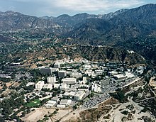
115:
281:
32:
180:
79:
238:
155:
71:
131:
123:
87:
286:
201:
59:
40:
185:
111:
83:
276:
175:
27:
241:
91:
102:
170:
75:
382:
205:
127:
114:
to the north over the San
Gabriel Mountains' ridgeline. They are generally along the
17:
271:
165:
220:
197:
67:
234:
230:
212:
51:
245:
223:
366:
375:"San Gabriel Valley." ROAD TRIP USA. N.p., n.d. Web. 04 Dec. 2012.
101:
26:
134:
in the east. The
Foothill Freeway superseded a highway known as
147:
The
Foothills and Hills in the San Gabriel Valley region include
55:
106:
View overlooking the valley from the foothills of
Claremont
360:
338:
126:
in the west, through the foothills and San
Gabriel and
312:"Climate, Fire, and Habitat in Southern California."
118:
freeway, giving it the name "Foothill Freeway". The
313:
404:Mountain ranges of Los Angeles County, California
292:Interstate 210 and State Route 210 (California)
8:
324:
322:
208:. The undeveloped hill areas are part of
308:
306:
302:
82:region. The landforms are part of the
7:
210:California's chaparral and woodlands
110:The ranges are roughly parallel the
70:. They include the foothills of the
389:Geography of the San Gabriel Valley
48:foothills of the San Gabriel Valley
367:http://geology.campus.ad.csulb.edu
120:Interstate 210 and State Route 210
39:, in the foothills of the western
25:
122:freeway covers 86 miles, between
369:. N.p., n.d. Web. 04 Dec. 2012.
217:montane chaparral and woodlands
363:. N.p., n.d. Web. 6 Dec. 2012.
359:"Frequently Asked Questions."
341:. N.p., n.d. Web. 6 Dec. 2012.
316:. N.p., n.d. Web. 6 Dec. 2012.
1:
337:Frequently Asked Questions."
248:, with some species of their
425:
272:Eaton Canyon Nature Center
142:Foothills and hill ranges
33:Jet Propulsion Laboratory
361:http://www.fire.ca.gov
339:http://www.fire.ca.gov
196:The foothills provide
107:
78:of hills, in the east
74:, and independent low
43:
399:San Gabriel Mountains
156:San Gabriel Mountains
105:
72:San Gabriel Mountains
30:
18:San Gabriel Foothills
202:Open Space Preserves
192:Natural environments
394:Greater Los Angeles
160:along southern face
88:Southern California
80:Greater Los Angeles
409:San Gabriel Valley
287:Puente Hills Fault
136:Foothill Boulevard
108:
64:Los Angeles County
60:San Gabriel Valley
44:
41:San Gabriel Valley
242:plant communities
186:Verdugo Mountains
154:Foothills of the
112:San Andreas Fault
84:Transverse Ranges
16:(Redirected from
416:
342:
335:
329:
326:
317:
314:http://ucanr.edu
310:
277:Foothill Transit
176:San Rafael Hills
21:
424:
423:
419:
418:
417:
415:
414:
413:
379:
378:
350:
345:
336:
332:
327:
320:
311:
304:
300:
268:
259:
194:
144:
100:
92:Baja California
76:mountain ranges
23:
22:
15:
12:
11:
5:
422:
420:
412:
411:
406:
401:
396:
391:
381:
380:
377:
376:
373:
370:
364:
357:
354:
349:
346:
344:
343:
330:
318:
301:
299:
296:
295:
294:
289:
284:
279:
274:
267:
264:
258:
255:
206:Regional parks
193:
190:
189:
188:
183:
178:
173:
171:San Jose Hills
168:
163:
151:
150:
148:
143:
140:
128:Pomona Valleys
116:Interstate 210
99:
96:
24:
14:
13:
10:
9:
6:
4:
3:
2:
421:
410:
407:
405:
402:
400:
397:
395:
392:
390:
387:
386:
384:
374:
371:
368:
365:
362:
358:
355:
352:
351:
347:
340:
334:
331:
325:
323:
319:
315:
309:
307:
303:
297:
293:
290:
288:
285:
283:
280:
278:
275:
273:
270:
269:
265:
263:
256:
254:
251:
250:native plants
247:
244:evolved with
243:
240:
236:
232:
227:
225:
222:
218:
214:
211:
207:
203:
199:
191:
187:
184:
182:
179:
177:
174:
172:
169:
167:
164:
161:
157:
153:
152:
149:
146:
145:
141:
139:
137:
133:
129:
125:
121:
117:
113:
104:
97:
95:
93:
89:
85:
81:
77:
73:
69:
65:
61:
57:
53:
49:
42:
38:
34:
29:
19:
333:
282:Metro A Line
260:
239:oak woodland
228:
221:Oak savannas
200:and contain
195:
166:Puente Hills
159:
109:
47:
45:
257:Fire danger
181:South Hills
62:of eastern
35:complex in
383:Categories
348:References
198:greenbelts
86:System of
68:California
246:wildfires
235:grassland
231:chaparral
213:ecoregion
98:Geography
52:foothills
50:are the
37:La Cañada
266:See also
224:habitats
132:Redlands
215:– with
58:in the
237:, and
229:Their
124:Sylmar
298:Notes
130:, to
56:hills
219:and
204:and
90:and
54:and
46:The
31:The
385::
321:^
305:^
233:,
226:.
158:–
138:.
94:.
66:,
162:.
20:)
Text is available under the Creative Commons Attribution-ShareAlike License. Additional terms may apply.