343:
177:
292:
According to the Los
Angeles Tri Weekly News: On Sept. 14 1865 the sheriff with a posse of three soldiers and two or three citizens ran across Henry sound asleep near San Jacinto Canyon, 25 miles from town and killed him after he made some resistance wounding one man. Secrest,
408:
384:
221:
377:
281:
46:
250:
in 1870 and ran the vineyard and winery with Joseph S. Garcia. In 1874 the
Sainsevain brothers purchased land in Hawker Canyon four miles east of
370:
282:
M. David DeSoucy, Sheriff Gary Penrod, San
Bernardino County Sheriff's Department, Arcadia Publishing, 2006. pg. 16. account of Henry shootout.
251:
324:
350:
86:
201:
120:
403:
316:
153:
232:
165:
39:
342:
224:
161:
311:
A companion to
California wine: an encyclopedia of wine and winemaking from the mission period to the present
213:
141:
137:
108:
247:
149:
209:
197:
320:
354:
243:
239:
193:
181:
228:
115:
309:
208:
and law enforcement officials in
Central California. They moved into pro secessionist
133:
101:
270:
397:
94:
176:
189:
157:
220:, committing robbery and murder as they did. Henry was killed by a posse led by
205:
145:
90:
61:
48:
188:
Before the flat acquired its current name it was the hideout of the outlaw
271:
San
Sevaine Flats, California; from www.topoquest.com, accessed 2/23/2013
217:
29:
231:, just over what was then the San Diego County line, in what is now
204:
the gang with a price on their heads, came under pressure from the
175:
212:
and split up. Henry with part of the gang moved into the eastern
358:
168:. It has an elevation of 1,690 meters, or 5,545 feet.
254:
and built a large stone house and a reservoir there.
246:in 1865 and set out a large vineyard. He moved to
114:
100:
82:
77:
38:
28:
23:
18:
308:
409:San Bernardino County, California geography stubs
378:
8:
238:The flat was named (but misspelled) for Don
216:at San Sevaine Flats from which they began
385:
371:
192:better known as James or Jim Henry of the
180:The San Sevaine Flats are named after Don
15:
263:
200:ended in April with Lee's surrender at
242:, who with his brother bought part of
7:
339:
337:
132:is a small area of flatland east of
357:. You can help Knowledge (XXG) by
14:
351:San Bernardino County, California
341:
307:Sullivan, Charles Lewis (1998).
317:University of California Press
154:San Bernardino National Forest
1:
222:San Bernardino County Sheriff
233:Riverside County, California
166:Rancho Cucamonga, California
34:5,545 ft (1,690 m)
425:
336:
227:on September 14, 1865, at
225:Benjamin Franklin Mathews
353:–related article is a
185:
162:South Fork Lytle Creek
156:, 1.24 miles south of
148:. The area is in the
404:San Gabriel Mountains
214:San Gabriel Mountains
179:
142:San Bernardino County
138:San Gabriel Mountains
109:San Gabriel Mountains
87:San Bernardino County
150:Cucamonga Wilderness
210:Southern California
58: /
295:California Bad Men
229:San Jacinto Canyon
198:American Civil War
186:
62:34.212°N 117.510°W
24:Highest point
366:
365:
326:978-0-520-21351-7
315:(1998 ed.).
130:San Sevaine Flats
127:
126:
19:San Sevaine Flats
416:
387:
380:
373:
345:
338:
331:
330:
314:
304:
298:
290:
284:
279:
273:
268:
244:Rancho Cucamonga
240:Pedro Sainsevain
194:Mason Henry Gang
182:Pedro Sainsevain
104:
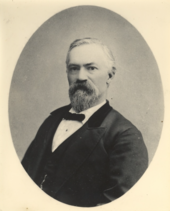
73:
72:
70:
69:
68:
67:34.212; -117.510
63:
59:
56:
55:
54:
51:
16:
424:
423:
419:
418:
417:
415:
414:
413:
394:
393:
392:
391:
335:
334:
327:
306:
305:
301:
291:
287:
280:
276:
269:
265:
260:
174:
102:
66:
64:
60:
57:
52:
49:
47:
45:
44:
12:
11:
5:
422:
420:
412:
411:
406:
396:
395:
390:
389:
382:
375:
367:
364:
363:
346:
333:
332:
325:
299:
285:
274:
262:
261:
259:
256:
173:
170:
134:Cucamonga Peak
125:
124:
123:Cucamonga Peak
118:
112:
111:
106:
98:
97:
84:
80:
79:
75:
74:
42:
36:
35:
32:
26:
25:
21:
20:
13:
10:
9:
6:
4:
3:
2:
421:
410:
407:
405:
402:
401:
399:
388:
383:
381:
376:
374:
369:
368:
362:
360:
356:
352:
347:
344:
340:
328:
322:
318:
313:
312:
303:
300:
296:
289:
286:
283:
278:
275:
272:
267:
264:
257:
255:
253:
249:
245:
241:
236:
234:
230:
226:
223:
219:
215:
211:
207:
203:
199:
195:
191:
183:
178:
171:
169:
167:
164:and north of
163:
159:
155:
151:
147:
143:
139:
135:
131:
122:
119:
117:
113:
110:
107:
105:
99:
96:
92:
88:
85:
81:
76:
71:
43:
41:
37:
33:
31:
27:
22:
17:
359:expanding it
348:
310:
302:
294:
288:
277:
266:
237:
196:. When the
190:Tom McCauley
187:
158:Bonita Falls
129:
128:
103:Parent range
65: /
53:117°30′36″W
40:Coordinates
398:Categories
258:References
206:Union Army
202:Appomattox
146:California
91:California
50:34°12′43″N
297:p.144-146
248:Cucamonga
78:Geography
30:Elevation
252:Etiwanda
218:rustling
116:Topo map
83:Location
172:History
152:in the
136:in the
323:
349:This
355:stub
321:ISBN
121:USGS
95:U.S.
235:.
160:on
140:in
400::
319:.
144:,
93:,
89:,
386:e
379:t
372:v
361:.
329:.
184:.
Text is available under the Creative Commons Attribution-ShareAlike License. Additional terms may apply.