1296:
1740:
65:
378:
1203:
1344:
45:
369:. The latter is made up of local Navajos from the area and relocated Navajo refugees from the Navajo/Hopi land dispute. That dispute relocated hundreds of Navajos to the Sanders area from the western Navajo Nation, mainly around the Hopi partitioned land. The area was mostly ranchland until the U.S. government bought it and added it to the Navajo Nation in 1981.
72:
1210:
As of the census of 2010, there were 630 people, 200 households, and 151 families residing in the CDP. The population density was 262.5 inhabitants per square mile (101.4/km). There were 242 housing units at an average density of 100.8 per square mile (38.9/km). The racial makeup of the CDP was 71.4%
1242:
There were 200 households, of which 48.5% had children under the age of 18, 44.5% were headed by married couples living together, 25.0% had a female householder with no husband present, and 24.5% were non-families. Individuals made up 21.0% of all households, and 4.5% were 65 years of age or older,
1246:
In the CDP, the age distribution of the population was 37.1% under the age of 18, 9.7% from 18 to 24, 24.0% from 25 to 44, 21.3 from 45 to 64, and 7.8% who were 65 years of age or older. The median age was 26.8 years. For every 100 females, there were 84.8 males. For every 100 females age 18 and
1518:
1291:
Sanders is served by the Nahata Dziil Health Clinic which opened in 2015. It is part of the Tséhootsooí Medical Center, located in Fort
Defiance, Arizona. Sanders Clinic, which is part of the St. Michael's Clinic, also serves the area.
2197:
1678:
1126:
2207:
2202:
1357:
1275:
1250:
For the period 2007–11, the estimated median annual income for a household in the CDP was $ 23,816, and the median income for a family was $ 24,375. The
1593:
1567:
1415:
93:
1646:
265:
1671:
2095:
275:
1811:
1484:
1278:
provides high school education. The elementary and middle school are on federal land, while the high school is on reservation land.
361:
runs near the town and some sections of the highway still exist. Sanders is surrounded by the Nahata Dziil and (north of the town)
1892:
1376:
474:
64:
1664:
1267:
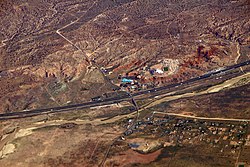
2113:
1656:
1594:"Selected Economic Characteristics: 22007-2011 American Community Survey 5-Year Estimates (DP03): Sanders CDP, Arizona"
1568:"Profile of General Population and Housing Characteristics: 2010 Demographic Profile Data (DP-1): Sanders CDP, Arizona"
1295:
1236:
1232:
1228:
1224:
1220:
1216:
1212:
413:
245:
224:
145:
1597:
1571:
1419:
1181:
1166:
327:
319:
2087:
386:
358:
323:
1400:
338:
Sanders' English name either comes from C.W. Sanders, a railroad office engineer, or Art
Saunders, who had a
44:
2125:
2072:
2042:
1778:
307:
35:
2212:
2167:
2032:
2017:
1826:
1768:
1688:
311:
150:
2047:
1937:
1912:
1763:
1325:
1651:
2174:
2077:
1962:
1882:
1329:
443:
234:
377:
1972:
1957:
1907:
1902:
1897:
1861:
1851:
1821:
1816:
1806:
458:
439:
2105:
2052:
2022:
1987:
1932:
1729:
1710:
406:
398:
1540:
1619:
2027:
1997:
1992:
1887:
1877:
1846:
1791:
1480:
1251:
470:
394:
390:
2082:
2067:
2007:
1982:
1922:
1872:
1254:
for the CDP was $ 6,741. About 36.6% of families and 33.1% of the population were below the
420:
488:
Climate data for
Sanders, Arizona (1991–2020 normals, extremes 1949–1956 and 1965–present)
2144:
2062:
2057:
2037:
1952:
1947:
1927:
1866:
1856:
1831:
1801:
1796:
1786:
291:
1243:
living alone. The average household size was 3.15, and the average family size was 3.71.
1202:
1942:
1841:
1836:
1758:
1750:
1721:
1349:
1313:
402:
362:
2191:
2119:
2012:
2002:
1309:
888:
366:
350:
1416:"Geographic Identifiers: 2010 Demographic Profile Data (G001): Sanders CDP, Arizona"
1271:
1255:
424:
354:
339:
1465:
1442:
416:, the Sanders CDP has a total area of 2.4 square miles (6.2 km), all land.
2136:
1703:
435:
1496:
1339:
133:
108:
95:
1401:
U.S. Geological Survey
Geographic Names Information System: Sanders, Arizona
1328:
which runs a local weekday bus route from the Nahata Dziil
Chapter House to
454:
450:
215:
346:
to avoid confusion with another station named
Sanders already on the line.
2158:‡This populated place also has portions in an adjacent county or counties
253:
431:
315:
138:
1274:
to grade 5 with
Sanders Middle School operating from grades 6 to 8.
1227:, 0.5% Asian, 0.2% Native Hawaiian or other Pacific Islander, 0.8%
1294:
1201:
376:
241:
220:
1231:, and 4.3% from two or more races. 3.8% of the population were
50:
1660:
1738:
1596:. U.S. Census Bureau, American Factfinder. Archived from
1570:. U.S. Census Bureau, American Factfinder. Archived from
1418:. U.S. Census Bureau, American Factfinder. Archived from
318:, United States. Sanders is located at the junction of
1270:. Sanders Elementary School provides education from
2153:
2135:
2104:
1971:
1777:
1749:
1720:
1299:
The Nahata Dziil Health Center in
Sanders, Arizona.
274:
264:
252:
231:
214:
206:
198:
193:
185:
177:
169:
161:
156:
144:
132:
124:
26:
2198:Census-designated places in Apache County, Arizona
430:The vegetation of the surrounding region includes
1562:
1560:
1558:
1521:. National Oceanic and Atmospheric Administration
1499:. National Oceanic and Atmospheric Administration
21:Census-designated place in Arizona, United States
1620:"Navajo Transit System > Route and Schedules"
419:Sanders is located on the southern edge of the
389:. Via I-40 it is 6 miles (10 km) west to
1672:
1410:
1408:
8:
1316:which runs from south to north of the town.
298:
1358:List of census-designated places in Arizona
1266:Education in the community is organized by
1679:
1665:
1657:
1139:
484:
23:
1447:. University of Arizona Press. p. 22
1324:Public transportation is provided by the
427:with Puerco Ridge visible to the south.
1368:
438:and a variety of native plants such as
342:nearby. The railroad station was named
263:
251:
213:
192:
184:
155:
123:
88:
57:
41:
1519:"Summary of Monthly Normals 1991-2020"
1396:
1394:
1159:
481:) with cold winters and hot summers.
405:leads south 54 miles (87 km) to
273:
230:
205:
197:
176:
168:
160:
143:
131:
7:
2208:Populated places established in 1868
1497:"NOWData - NOAA Online Weather Data"
457:, elk, mountain lions, black bears,
397:, and 44 miles (71 km) east to
2203:Census-designated places in Arizona
1308:Sanders is located directly off of
181:0.00 sq mi (0.00 km)
173:2.59 sq mi (6.70 km)
165:2.59 sq mi (6.71 km)
1687:Municipalities and communities of
1541:"Census of Population and Housing"
1149:
449:Wildlife seen in the area include
385:Sanders is located at Exit 339 on
14:
1624:www.navajotransit.navajo-nsn.gov
1479:, DeLorme, 4th ed., 2001, p. 45
1342:
393:, 53 miles (85 km) west to
70:
63:
43:
1647:Sanders Unified School District
1466:Navajo - Hopi Long Land Dispute
1268:Sanders Unified School District
71:
330:, it had a population of 575.
1:
1764:Nahata Dziil (Navajo Chapter)
1477:Arizona Atlas & Gazetteer
1379:. United States Census Bureau
1312:which runs east to west, and
1247:over, there were 80.0 males.
961:Average snowfall inches (cm)
16:CDP in Apache County, Arizona
210:222.18/sq mi (85.78/km)
189:5,866 ft (1,788 m)
1377:"2020 U.S. Gazetteer Files"
1031:Average precipitation days
747:Mean daily minimum °F (°C)
607:Mean daily maximum °F (°C)
414:United States Census Bureau
2229:
1652:Sanders profile, Zip 86512
1206:Welcome sign in Sanders AZ
1124:
487:
2163:
1736:
1701:
1195:
1180:
1165:
1158:
1153:
1148:
1145:
1077:
1030:
960:
886:
816:
746:
676:
606:
536:
531:
528:
525:
522:
519:
516:
513:
510:
507:
504:
501:
498:
495:
492:
89:
58:
42:
33:
1441:Byrd H. Granger (1960).
349:Sanders is located near
461:, coyotes and turkeys.
308:census-designated place
36:Census-designated place
1743:
1690:Apache County, Arizona
1300:
1207:
382:
299:
295:
109:35.20889°N 109.32278°W
1742:
1326:Navajo Transit System
1320:Public transportation
1298:
1205:
1196:U.S. Decennial Census
1141:Historical population
380:
233: • Summer (
2176:United States portal
1600:on February 12, 2020
1574:on February 12, 2020
1422:on February 12, 2020
537:Record high °F (°C)
207: • Density
114:35.20889; -109.32278
2106:Indian reservations
1444:Arizona Place Names
1142:
1078:Average snowy days
817:Record low °F (°C)
677:Daily mean °F (°C)
469:Sanders has a cold
459:Mexican gray wolves
440:prickly pear cactus
381:Puerco Valley Ridge
105: /
1744:
1301:
1276:Valley High School
1208:
1140:
423:, adjacent to the
399:Gallup, New Mexico
383:
199: • Total
178: • Water
162: • Total
2185:
2184:
1252:per capita income
1200:
1199:
1132:
1131:
471:semi-arid climate
412:According to the
285:
284:
170: • Land
2220:
2177:
2170:
1741:
1713:
1706:
1696:
1691:
1681:
1674:
1667:
1658:
1635:
1634:
1632:
1630:
1616:
1610:
1609:
1607:
1605:
1590:
1584:
1583:
1581:
1579:
1564:
1553:
1552:
1550:
1548:
1537:
1531:
1530:
1528:
1526:
1515:
1509:
1508:
1506:
1504:
1493:
1487:
1474:
1468:
1463:
1457:
1456:
1454:
1452:
1438:
1432:
1431:
1429:
1427:
1412:
1403:
1398:
1389:
1388:
1386:
1384:
1373:
1352:
1347:
1346:
1345:
1225:African American
1161:
1156:
1151:
1143:
1081:
1034:
485:
421:Defiance Plateau
365:chapters of the
303:
302:
300:Łichííʼ Deezʼáhí
238:
120:
119:
117:
116:
115:
110:
106:
103:
102:
101:
98:
74:
73:
67:
47:
28:Sanders, Arizona
24:
2228:
2227:
2223:
2222:
2221:
2219:
2218:
2217:
2188:
2187:
2186:
2181:
2175:
2168:
2159:
2149:
2131:
2100:
2088:Tsintaa Yiti Ii
1974:
1967:
1773:
1745:
1739:
1734:
1716:
1711:
1704:
1697:
1694:
1689:
1685:
1643:
1638:
1628:
1626:
1618:
1617:
1613:
1603:
1601:
1592:
1591:
1587:
1577:
1575:
1566:
1565:
1556:
1546:
1544:
1539:
1538:
1534:
1524:
1522:
1517:
1516:
1512:
1502:
1500:
1495:
1494:
1490:
1475:
1471:
1464:
1460:
1450:
1448:
1440:
1439:
1435:
1425:
1423:
1414:
1413:
1406:
1399:
1392:
1382:
1380:
1375:
1374:
1370:
1366:
1348:
1343:
1341:
1338:
1322:
1306:
1289:
1284:
1264:
1229:some other race
1213:Native American
1154:
1138:
1133:
1079:
1032:
1025:
1020:
1015:
1010:
1005:
1000:
995:
990:
985:
980:
975:
970:
965:
955:
950:
945:
940:
935:
930:
925:
920:
915:
910:
905:
900:
895:
881:
876:
871:
866:
861:
856:
851:
846:
841:
836:
831:
826:
821:
811:
806:
801:
796:
791:
786:
781:
776:
771:
766:
761:
756:
751:
741:
736:
731:
726:
721:
716:
711:
706:
701:
696:
691:
686:
681:
671:
666:
661:
656:
651:
646:
641:
636:
631:
626:
621:
616:
611:
601:
596:
591:
586:
581:
576:
571:
566:
561:
556:
551:
546:
541:
467:
375:
336:
297:
260:
232:
113:
111:
107:
104:
99:
96:
94:
92:
91:
85:
84:
83:
82:
81:
80:
79:
75:
54:
38:
29:
22:
17:
12:
11:
5:
2226:
2224:
2216:
2215:
2210:
2205:
2200:
2190:
2189:
2183:
2182:
2180:
2179:
2172:
2169:Arizona portal
2164:
2161:
2160:
2157:
2155:
2151:
2150:
2148:
2147:
2141:
2139:
2133:
2132:
2130:
2129:
2123:
2117:
2110:
2108:
2102:
2101:
2099:
2098:
2093:
2090:
2085:
2080:
2075:
2073:Tanner Springs
2070:
2065:
2060:
2055:
2050:
2045:
2043:Navajo Springs
2040:
2035:
2030:
2025:
2020:
2015:
2010:
2005:
2000:
1995:
1990:
1985:
1979:
1977:
1969:
1968:
1966:
1965:
1960:
1955:
1950:
1945:
1940:
1935:
1930:
1925:
1920:
1915:
1910:
1905:
1900:
1895:
1890:
1885:
1880:
1875:
1870:
1864:
1859:
1854:
1849:
1844:
1839:
1834:
1829:
1824:
1819:
1814:
1809:
1804:
1799:
1794:
1789:
1783:
1781:
1775:
1774:
1772:
1771:
1766:
1761:
1755:
1753:
1747:
1746:
1737:
1735:
1733:
1732:
1726:
1724:
1718:
1717:
1702:
1699:
1698:
1686:
1684:
1683:
1676:
1669:
1661:
1655:
1654:
1649:
1642:
1641:External links
1639:
1637:
1636:
1611:
1585:
1554:
1532:
1510:
1488:
1469:
1458:
1433:
1404:
1390:
1367:
1365:
1362:
1361:
1360:
1354:
1353:
1350:Arizona portal
1337:
1334:
1321:
1318:
1314:U.S. Route 191
1305:
1304:Transportation
1302:
1288:
1285:
1283:
1282:Infrastructure
1280:
1263:
1260:
1198:
1197:
1193:
1192:
1189:
1187:
1184:
1178:
1177:
1174:
1172:
1169:
1163:
1162:
1157:
1152:
1147:
1137:
1134:
1130:
1129:
1122:
1121:
1118:
1115:
1112:
1109:
1106:
1103:
1100:
1097:
1094:
1091:
1088:
1085:
1082:
1075:
1074:
1071:
1068:
1065:
1062:
1059:
1056:
1053:
1050:
1047:
1044:
1041:
1038:
1035:
1028:
1027:
1022:
1017:
1012:
1007:
1002:
997:
992:
987:
982:
977:
972:
967:
962:
958:
957:
952:
947:
942:
937:
932:
927:
922:
917:
912:
907:
902:
897:
892:
884:
883:
878:
873:
868:
863:
858:
853:
848:
843:
838:
833:
828:
823:
818:
814:
813:
808:
803:
798:
793:
788:
783:
778:
773:
768:
763:
758:
753:
748:
744:
743:
738:
733:
728:
723:
718:
713:
708:
703:
698:
693:
688:
683:
678:
674:
673:
668:
663:
658:
653:
648:
643:
638:
633:
628:
623:
618:
613:
608:
604:
603:
598:
593:
588:
583:
578:
573:
568:
563:
558:
553:
548:
543:
538:
534:
533:
530:
527:
524:
521:
518:
515:
512:
509:
506:
503:
500:
497:
494:
490:
489:
483:
466:
463:
403:U.S. Route 191
374:
371:
335:
332:
320:U.S. Route 191
283:
282:
279:
272:
271:
268:
262:
261:
258:
256:
250:
249:
239:
229:
228:
218:
212:
211:
208:
204:
203:
200:
196:
195:
191:
190:
187:
183:
182:
179:
175:
174:
171:
167:
166:
163:
159:
158:
154:
153:
148:
142:
141:
136:
130:
129:
126:
122:
121:
87:
86:
77:
76:
69:
68:
62:
61:
60:
59:
56:
55:
48:
40:
39:
34:
31:
30:
27:
20:
15:
13:
10:
9:
6:
4:
3:
2:
2225:
2214:
2213:Navajo Nation
2211:
2209:
2206:
2204:
2201:
2199:
2196:
2195:
2193:
2178:
2173:
2171:
2166:
2165:
2162:
2156:
2152:
2146:
2143:
2142:
2140:
2138:
2134:
2127:
2124:
2121:
2118:
2115:
2112:
2111:
2109:
2107:
2103:
2097:
2094:
2091:
2089:
2086:
2084:
2081:
2079:
2076:
2074:
2071:
2069:
2066:
2064:
2061:
2059:
2056:
2054:
2051:
2049:
2046:
2044:
2041:
2039:
2036:
2034:
2033:Mexican Water
2031:
2029:
2026:
2024:
2021:
2019:
2018:Hunters Point
2016:
2014:
2011:
2009:
2006:
2004:
2001:
1999:
1996:
1994:
1991:
1989:
1986:
1984:
1981:
1980:
1978:
1976:
1970:
1964:
1961:
1959:
1956:
1954:
1951:
1949:
1946:
1944:
1941:
1939:
1936:
1934:
1931:
1929:
1926:
1924:
1921:
1919:
1916:
1914:
1911:
1909:
1906:
1904:
1901:
1899:
1896:
1894:
1891:
1889:
1886:
1884:
1881:
1879:
1876:
1874:
1871:
1868:
1865:
1863:
1860:
1858:
1855:
1853:
1850:
1848:
1845:
1843:
1840:
1838:
1835:
1833:
1830:
1828:
1827:Fort Defiance
1825:
1823:
1820:
1818:
1815:
1813:
1810:
1808:
1805:
1803:
1800:
1798:
1795:
1793:
1790:
1788:
1785:
1784:
1782:
1780:
1776:
1770:
1769:Springerville
1767:
1765:
1762:
1760:
1757:
1756:
1754:
1752:
1748:
1731:
1728:
1727:
1725:
1723:
1719:
1715:
1714:
1707:
1700:
1695:United States
1692:
1682:
1677:
1675:
1670:
1668:
1663:
1662:
1659:
1653:
1650:
1648:
1645:
1644:
1640:
1625:
1621:
1615:
1612:
1599:
1595:
1589:
1586:
1573:
1569:
1563:
1561:
1559:
1555:
1542:
1536:
1533:
1520:
1514:
1511:
1498:
1492:
1489:
1486:
1485:0-89933-325-7
1482:
1478:
1473:
1470:
1467:
1462:
1459:
1446:
1445:
1437:
1434:
1421:
1417:
1411:
1409:
1405:
1402:
1397:
1395:
1391:
1378:
1372:
1369:
1363:
1359:
1356:
1355:
1351:
1340:
1335:
1333:
1331:
1327:
1319:
1317:
1315:
1311:
1310:Interstate 40
1303:
1297:
1293:
1286:
1281:
1279:
1277:
1273:
1269:
1261:
1259:
1257:
1253:
1248:
1244:
1240:
1239:of any race.
1238:
1234:
1230:
1226:
1222:
1218:
1214:
1204:
1194:
1190:
1188:
1185:
1183:
1179:
1175:
1173:
1170:
1168:
1164:
1144:
1135:
1128:
1123:
1119:
1116:
1113:
1110:
1107:
1104:
1101:
1098:
1095:
1092:
1089:
1086:
1083:
1076:
1072:
1069:
1066:
1063:
1060:
1057:
1054:
1051:
1048:
1045:
1042:
1039:
1036:
1033:(≥ 0.01 inch)
1029:
1023:
1018:
1013:
1008:
1003:
998:
993:
988:
983:
978:
973:
968:
963:
959:
953:
948:
943:
938:
933:
928:
923:
918:
913:
908:
903:
898:
893:
890:
889:precipitation
885:
879:
874:
869:
864:
859:
854:
849:
844:
839:
834:
829:
824:
819:
815:
809:
804:
799:
794:
789:
784:
779:
774:
769:
764:
759:
754:
749:
745:
739:
734:
729:
724:
719:
714:
709:
704:
699:
694:
689:
684:
679:
675:
669:
664:
659:
654:
649:
644:
639:
634:
629:
624:
619:
614:
609:
605:
599:
594:
589:
584:
579:
574:
569:
564:
559:
554:
549:
544:
539:
535:
491:
486:
482:
480:
476:
472:
464:
462:
460:
456:
452:
447:
445:
441:
437:
433:
428:
426:
422:
417:
415:
410:
408:
404:
400:
396:
392:
388:
387:Interstate 40
379:
372:
370:
368:
367:Navajo Nation
364:
360:
356:
352:
351:Interstate 40
347:
345:
341:
333:
331:
329:
326:. As of the
325:
324:Interstate 40
321:
317:
313:
312:Apache County
309:
305:
304:
301:
293:
289:
280:
277:
269:
267:
257:
255:
247:
243:
240:
236:
226:
222:
219:
217:
209:
201:
188:
180:
172:
164:
152:
149:
147:
140:
137:
135:
128:United States
127:
118:
90:Coordinates:
66:
52:
46:
37:
32:
25:
19:
2048:Pine Springs
1938:Teec Nos Pos
1917:
1913:St. Michaels
1709:
1627:. Retrieved
1623:
1614:
1602:. Retrieved
1598:the original
1588:
1576:. Retrieved
1572:the original
1545:. Retrieved
1543:. Census.gov
1535:
1525:December 13,
1523:. Retrieved
1513:
1503:December 12,
1501:. Retrieved
1491:
1476:
1472:
1461:
1449:. Retrieved
1443:
1436:
1424:. Retrieved
1420:the original
1381:. Retrieved
1371:
1323:
1307:
1290:
1272:kindergarten
1265:
1256:poverty line
1249:
1245:
1241:
1209:
1136:Demographics
1080:(≥ 0.1 inch)
891:inches (mm)
478:
468:
448:
429:
425:Puerco River
418:
411:
384:
355:BNSF Railway
348:
343:
340:trading post
337:
296:
287:
286:
53:from the air
49:Sanders and
18:
2137:Ghost towns
2114:Fort Apache
2096:Wheatfields
2078:Tes Nez Iah
1963:Window Rock
1883:Oak Springs
1705:County seat
1629:November 8,
1451:December 9,
1383:October 29,
1330:Window Rock
328:2020 census
112: /
100:109°19′22″W
2192:Categories
2092:Twin Falls
1958:Wide Ruins
1908:Round Rock
1903:Rough Rock
1898:Rock Point
1862:Many Farms
1852:Lukachukai
1822:Dennehotso
1817:Del Muerto
1812:Cottonwood
1807:Cornfields
1364:References
436:pinón pine
278:feature ID
194:Population
97:35°12′32″N
2154:Footnotes
2053:Richville
2023:Kinlichee
1988:Allentown
1973:Populated
1933:Steamboat
1730:St. Johns
1712:St. Johns
1604:April 30,
1578:April 30,
1426:April 30,
1262:Education
455:mule deer
451:pronghorn
444:sagebrush
407:St. Johns
373:Geography
310:(CDP) in
266:FIPS code
216:Time zone
186:Elevation
2028:Maverick
1998:Chambers
1993:Blue Gap
1893:Red Rock
1888:Red Mesa
1878:Nutrioso
1847:Klagetoh
1792:Burnside
1336:See also
1233:Hispanic
1215:, 22.7%
1125:Source:
887:Average
395:Holbrook
391:Chambers
359:Route 66
353:and the
270:04-63050
254:ZIP code
2083:Totacon
2068:Tahchee
2008:El Tule
1983:Adamana
1923:Sawmill
1918:Sanders
1873:Nazlini
1547:June 4,
1219:, 0.2%
1016:(0.76)
807:(−7.2)
802:(−3.6)
787:(13.2)
782:(13.4)
767:(−0.6)
762:(−3.4)
757:(−5.4)
752:(−7.3)
742:(11.2)
727:(11.9)
722:(18.3)
717:(22.2)
712:(22.9)
707:(19.4)
702:(14.2)
672:(20.6)
662:(14.6)
657:(21.3)
652:(27.7)
647:(31.1)
642:(32.4)
637:(30.9)
632:(25.1)
627:(19.8)
622:(15.7)
617:(11.3)
465:Climate
432:juniper
334:History
316:Arizona
306:) is a
288:Sanders
281:2582858
139:Arizona
125:Country
78:Sanders
2145:Bannon
2120:Navajo
2063:Salina
2058:Salado
2038:Navajo
1975:places
1953:Vernon
1948:Tsaile
1928:Sehili
1867:McNary
1857:Lupton
1832:Ganado
1802:Concho
1797:Chinle
1787:Alpine
1483:
1287:Health
1237:Latino
1146:Census
1026:(9.1)
1021:(2.8)
1011:(0.0)
1006:(0.0)
1001:(0.0)
996:(0.0)
991:(0.0)
986:(0.0)
981:(0.0)
976:(1.8)
971:(1.8)
966:(2.0)
956:(207)
921:(2.8)
916:(8.1)
901:(9.7)
882:(−31)
877:(−29)
872:(−28)
867:(−14)
842:(−10)
837:(−15)
832:(−26)
827:(−30)
822:(−31)
812:(1.8)
797:(2.5)
792:(9.0)
777:(7.9)
772:(3.3)
737:(0.9)
732:(5.6)
697:(9.6)
692:(6.2)
687:(3.0)
682:(0.7)
667:(8.9)
612:(8.8)
493:Month
475:Köppen
357:. Old
292:Navajo
151:Apache
146:County
1943:Toyei
1842:Houck
1837:Greer
1759:Eagar
1751:Towns
1221:Black
1217:White
1191:−8.7%
1073:29.8
951:(18)
946:(18)
941:(22)
936:(13)
931:(35)
926:(30)
911:(10)
906:(18)
896:(23)
862:(−7)
847:(−4)
602:(42)
597:(25)
592:(26)
587:(32)
582:(38)
577:(38)
572:(42)
567:(39)
562:(36)
557:(30)
552:(30)
547:(23)
542:(22)
532:Year
363:Houck
344:Cheto
259:86512
242:UTC-7
221:UTC-7
134:State
2126:Zuni
2013:Hunt
2003:Cove
1779:CDPs
1722:City
1631:2020
1606:2013
1580:2013
1549:2016
1527:2022
1505:2022
1481:ISBN
1453:2011
1428:2013
1385:2021
1182:2020
1167:2010
1155:Note
1150:Pop.
1127:NOAA
1120:1.7
1117:0.4
1114:0.2
1111:0.0
1108:0.0
1105:0.0
1102:0.0
1099:0.0
1096:0.0
1093:0.0
1090:0.2
1087:0.3
1084:0.6
1070:1.8
1067:1.7
1064:2.2
1061:3.7
1058:5.2
1055:5.1
1052:0.7
1049:1.6
1046:1.2
1043:2.6
1040:1.5
1037:2.5
954:8.16
949:0.71
944:0.70
939:0.86
934:0.53
929:1.38
924:1.17
919:0.11
914:0.32
909:0.41
904:0.70
899:0.38
894:0.89
857:(0)
852:(2)
810:35.3
805:19.1
800:25.6
795:36.5
790:48.2
785:55.7
780:56.2
775:46.2
770:38.0
765:30.9
760:25.9
755:22.3
750:18.9
740:52.2
735:33.6
730:42.0
725:53.4
720:65.0
715:71.9
710:73.3
705:66.9
700:57.5
695:49.3
690:43.1
685:37.4
680:33.3
670:69.1
665:48.1
660:58.3
655:70.3
650:81.9
645:88.0
640:90.4
635:87.6
630:77.1
625:67.7
620:60.2
615:52.4
610:47.8
529:Dec
526:Nov
523:Oct
520:Sep
517:Aug
514:Jul
511:Jun
508:May
505:Apr
502:Mar
499:Feb
496:Jan
442:and
322:and
276:GNIS
157:Area
51:I-40
1235:or
1223:or
1186:575
1171:630
1024:3.6
1019:1.1
1014:0.3
1009:0.0
1004:0.0
999:0.0
994:0.0
989:0.0
984:0.0
979:0.0
974:0.7
969:0.7
964:0.8
880:−23
875:−20
870:−18
830:−15
825:−22
820:−23
600:107
580:100
575:101
570:107
565:102
479:BSk
246:MST
235:DST
225:MST
202:575
2194::
1708::
1693:,
1622:.
1557:^
1407:^
1393:^
1332:.
1258:.
1160:%±
860:20
855:32
850:35
845:25
840:14
595:77
590:79
585:90
560:96
555:86
550:86
545:74
540:72
477::
453:,
446:.
434:,
409:.
401:.
314:,
294::
2128:‡
2122:‡
2116:‡
1869:‡
1680:e
1673:t
1666:v
1633:.
1608:.
1582:.
1551:.
1529:.
1507:.
1455:.
1430:.
1387:.
1176:—
865:7
835:5
473:(
290:(
248:)
244:(
237:)
227:)
223:(
Text is available under the Creative Commons Attribution-ShareAlike License. Additional terms may apply.