655:
516:
468:
647:
626:, a 150-ton steamer, up the river to Springfield in March 1832. Some sources state that Lincoln himself piloted the first steamship up the Sangamon to Springfield, accomplishing this feat with many men, almost as large as Lincoln, with axes to chop through whatever trees impeded the journey. More likely Lincoln acted as a guide and axeman. In later years, he told of taking a steamship three miles (5 km) into the prairie after losing his way on the Sangamon during a flood. During his first campaign for the
507:
leaving a terminal moraine parallel to the modern
Sangamon River. The ice stagnated and melted behind this moraine, without the meltwater overtopping the terminal moraine. Along this stretch, the eastern part of the watershed of the Sangamon therefore consists of short creeks, two to three miles (3–5 km) in length, that drain the face of the moraine. This forms an asymmetric watershed typical of rivers formed along the face of a terminal moraine.
29:
506:
The upper
Sangamon, between Mahomet and Monticello, runs along the face of a terminal moraine within the Lake Michigan Glacial Lobe, which ranges in age from 28,000 to 12,000 BP. During the glacial Woodfordian Substage (middle Wisconsin Stage), ice of the Lake Michigan Glacial Lobe advanced rapidly,
630:
in 1832, he made navigational improvements on the river a centerpiece of his platform. From 1848 to 1860, Lincoln practiced law in the
Illinois Eighth Judicial Circuit, which meant he regularly crossed the river as he traveled around the circuit.
781:
353:
and played an important role in early
European settlement of Illinois, when the area around was known as the "Sangamon River Country". The section of the Sangamon River that flows through
593:. The 21-year-old Lincoln helped build a 16 foot by 16 foot (4.8 m by 4.8 m) cabin along the river. The following year in 1831, he canoed down the river to homestead on his own near
709:'s song "Decatur, Or, Round Of Applause For Your Stepmother!". Singer songwriter Ben Bedford references the Sangamon in several of his songs, one of which is titled after it.
973:
938:
499:
levels from agricultural runoff. Many times the city was forced to warn people not to allow babies to consume water in
Decatur because of "blue baby syndrome",
978:
691:
983:
963:
958:
993:
988:
968:
767:
654:
578:
settled the river valley beginning in 1825, giving the region a distinctive culture identified and described at the turn of the 20th century by
699:
586:
520:
528:
410:
310:
288:
758:
594:
585:
Abraham
Lincoln arrived with his family in the area in 1830 to settle a section of government land bisected by the river. The site, now
295:
824:
386:
164:
852:
444:, approximately 25 miles (40 km) north-northwest of Springfield; then the river turns west, forming the southern boundary of
763:
515:
683:
575:
95:
416:
467:
382:
726:
547:
settled along the river. In the middle 18th century, the region near the river was the scene of a conflict between the
953:
888:
472:
390:
646:
635:
627:
362:
616:
Lincoln was impressed by the navigational difficulties on the river, especially during the arrival of the first
998:
871:
810:
Wedron and Mason Groups: Lithostratigraphic
Reclassification of the Wisconsin Episode, Lake Michigan Lobe Area.
674:
for the people of
Central Illinois. Key parklands along the river, moving from upstream to downstream, include
659:
556:
753:
301:
449:
374:
81:
695:
663:
621:
610:
597:
in Menard County northwest of
Springfield. Later that year he floated down the river with companions on a
492:
445:
453:
406:
346:
913:
883:
658:
View looking N/NE of the
Sangamon (flowing from the right along the curve) and one of its tributaries,
679:
461:
398:
358:
354:
150:
536:
487:
the main stem of the river, with no control over upstream land uses, has had major problems with
848:
785:
606:
579:
500:
402:
394:
342:
268:
254:
221:
34:
563:
traders were active in the region throughout the middle 18th century when it was part of the
842:
564:
821:
893:
828:
544:
350:
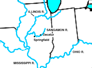
389:. The river's course forms a large arc through central Illinois, first flowing east into
706:
687:
602:
483:, constructed in 1920–1922 to provide a water supply for Decatur. This lake, formed by
457:
326:
262:
250:
146:
933:
928:
923:
918:
947:
334:
51:
739:
U.S. Geological Survey. National Hydrography Dataset high-resolution flowline data.
309:
898:
480:
574:
built a log-framed store, the first commercial building in Springfield. Groups of
650:
A concrete bridge over the Sangamon River in Robert Allerton Park, November 2007.
571:
552:
338:
131:
903:
675:
671:
431:
418:
179:
166:
110:
97:
617:
548:
488:
322:
727:"USGS Current Conditions for USGS 05583000 SANGAMON RIVER NEAR OAKFORD, IL"
543:
meaning "where there is plenty to eat." In the 18th century, groups of the
740:
598:
330:
812:
Bulletin no. 104, Illinois State Geological Survey, Champaign, Illinois.
590:
496:
484:
378:
28:
670:
Despite its environmental problems, the Sangamon River is a focus of
570:
The first U.S. settlers arrived in the region in the 1810s. In 1821,
560:
532:
503:. Decatur has now installed nitrate treatment to avoid this problem.
653:
645:
589:, was selected by Lincoln's father after the family migrated from
514:
466:
908:
847:. Carbondale: Southern Illinois University Press. pp. 1–3.
844:
Lincoln's Ladder to the Presidency: The Eighth Judicial Circuit
782:"Inside the massive effort to rid Lake Decatur of farm runoff"
831:, Illinois State Historical Society. Retrieved July 19, 2007.
894:
Illinois Genealogy Trails: Following Lincoln on the Sangamon
373:
The river rises from several short headstreams in southern
405:, then turning northwest to flow along the north side of
329:, approximately 246 miles (396 km) long, in central
686:, Lincoln Trail Homestead State Park, Springfield's
349:. The river is associated with the early career of
294:
282:
274:
260:
246:
241:
227:
215:
207:
195:
156:
140:
130:
87:
74:
66:
57:
47:
42:
21:
804:
802:
527:The river was home to many different groups of
385:. Part of the moraine is publicly owned as the
889:Northern Illinois University: Sangamon History
479:The Sangamon is impounded in Decatur to form
8:
939:Getting Involved with the Sangamon Watershed
692:Sangamon River State Fish and Wildlife Area
929:Surf the South Fork of the Sangamon River
768:United States Department of the Interior
308:
718:
531:in the centuries before the arrival of
899:John Knoepfle: Poems from the Sangamon
884:Abraham Lincoln and the Sangamon River
808:Hansel, A.K., and W.H. Johnson, 1996,
700:Sanganois State Fish and Wildlife Area
587:Lincoln Trail Homestead State Memorial
521:Lincoln Trail Homestead State Memorial
18:
535:. The name of the river comes from a
7:
974:Rivers of Champaign County, Illinois
682:, the parks bordering Lake Decatur,
979:Rivers of Sangamon County, Illinois
759:Geographic Names Information System
919:Surf the Upper Sangamon with USEPA
822:"Abraham Lincoln and the Talisman"
387:Moraine View State Recreation Area
14:
984:Rivers of Menard County, Illinois
964:Rivers of McLean County, Illinois
959:Tributaries of the Illinois River
473:Lake of the Woods Forest Preserve
994:Rivers of Mason County, Illinois
989:Rivers of Macon County, Illinois
27:
969:Rivers of Cass County, Illinois
764:United States Geological Survey
495:. The lake often has excessive
684:Rock Springs Conservation Area
158: • coordinates
89: • coordinates
1:
638:passed through here in 1838.
58:Physical characteristics
460:from the east just north of
383:Bloomington-Normal, Illinois
705:The river was mentioned in
337:. It drains a mostly rural
217: • location
142: • location
76: • location
1015:
391:Champaign County, Illinois
377:that arise from a glacial
229: • average
16:River in the United States
636:Potawatomi Trail of Death
628:Illinois General Assembly
605:, and then following the
432:40.1259000°N 89.8251000°W
363:National Natural Landmark
237:
203:
199:246 mi (396 km)
180:40.0225472°N 90.4329028°W
126:
111:40.4453111°N 88.7325667°W
62:
26:
914:Sangamon Watershed (PDF)
872:Rivers of America Series
690:and Riverside Park, the
576:Cumberland Presbyterians
557:French and Iroquois Wars
284: • right
33:The Sangamon River near
934:Surf the Salt Watershed
924:Surf the Lower Sangamon
841:Fraker, Guy C. (2011).
743:, accessed May 13, 2011
456:counties. It joins the
437:40.1259000; -89.8251000
185:40.0225472; -90.4329028
116:40.4453111; -88.7325667
82:McLean County, Illinois
909:Prairie Rivers Network
667:
651:
555:as part of the larger
524:
493:agricultural pollution
476:
471:The Sangamon River in
341:area and runs through
314:
657:
649:
518:
470:
312:
233:3,639 cu/ft. per sec.
698:, Saybrook, and the
680:Robert Allerton Park
397:, then west through
355:Robert Allerton Park
151:Beardstown, Illinois
904:Fox (Meskwaki) wars
696:Lincoln's New Salem
428: /
242:Basin features
176: /
107: /
954:Rivers of Illinois
827:2007-09-25 at the
668:
652:
525:
519:Sangamon river at
477:
315:
786:Herald and Review
607:Mississippi River
580:Edgar Lee Masters
501:Methemoglobinemia
307:
306:
269:Mississippi River
255:Mississippi River
222:Oakford, Illinois
1006:
859:
858:
838:
832:
819:
813:
806:
797:
796:
794:
793:
784:. (Decatur, IL)
778:
772:
771:
754:"Sangamon River"
750:
744:
741:The National Map
737:
731:
730:
723:
664:Macon County, IL
565:Illinois Country
529:Native Americans
443:
442:
440:
439:
438:
433:
429:
426:
425:
424:
421:
393:, south through
285:
265:
230:
218:
191:
190:
188:
187:
186:
181:
177:
174:
173:
172:
169:
122:
121:
119:
118:
117:
112:
108:
105:
104:
103:
100:
90:
77:
31:
19:
1014:
1013:
1009:
1008:
1007:
1005:
1004:
1003:
999:Abraham Lincoln
944:
943:
880:
868:
863:
862:
855:
840:
839:
835:
829:Wayback Machine
820:
816:
807:
800:
791:
789:
780:
779:
775:
752:
751:
747:
738:
734:
725:
724:
720:
715:
644:
642:The river today
513:
436:
434:
430:
427:
422:
419:
417:
415:
414:
371:
351:Abraham Lincoln
321:is a principal
283:
261:
228:
216:
184:
182:
178:
175:
170:
167:
165:
163:
162:
159:
143:
115:
113:
109:
106:
101:
98:
96:
94:
93:
88:
75:
38:
17:
12:
11:
5:
1012:
1010:
1002:
1001:
996:
991:
986:
981:
976:
971:
966:
961:
956:
946:
945:
942:
941:
936:
931:
926:
921:
916:
911:
906:
901:
896:
891:
886:
879:
878:External links
876:
875:
874:
867:
864:
861:
860:
853:
833:
814:
798:
773:
745:
732:
717:
716:
714:
711:
707:Sufjan Stevens
688:Carpenter Park
643:
640:
603:Illinois River
512:
509:
458:Illinois River
409:. It receives
370:
367:
327:Illinois River
319:Sangamon River
313:Sangamon River
305:
304:
299:
292:
291:
286:
280:
279:
276:
272:
271:
266:
258:
257:
251:Illinois River
248:
244:
243:
239:
238:
235:
234:
231:
225:
224:
219:
213:
212:
209:
205:
204:
201:
200:
197:
193:
192:
160:
157:
154:
153:
147:Illinois River
144:
141:
138:
137:
134:
128:
127:
124:
123:
91:
85:
84:
78:
72:
71:
68:
64:
63:
60:
59:
55:
54:
49:
45:
44:
40:
39:
32:
24:
23:
22:Sangamon River
15:
13:
10:
9:
6:
4:
3:
2:
1011:
1000:
997:
995:
992:
990:
987:
985:
982:
980:
977:
975:
972:
970:
967:
965:
962:
960:
957:
955:
952:
951:
949:
940:
937:
935:
932:
930:
927:
925:
922:
920:
917:
915:
912:
910:
907:
905:
902:
900:
897:
895:
892:
890:
887:
885:
882:
881:
877:
873:
870:
869:
865:
856:
854:9780809332021
850:
846:
845:
837:
834:
830:
826:
823:
818:
815:
811:
805:
803:
799:
787:
783:
777:
774:
769:
765:
761:
760:
755:
749:
746:
742:
736:
733:
728:
722:
719:
712:
710:
708:
703:
701:
697:
693:
689:
685:
681:
677:
673:
665:
661:
660:Stevens Creek
656:
648:
641:
639:
637:
632:
629:
625:
624:
619:
614:
612:
608:
604:
600:
596:
592:
588:
583:
581:
577:
573:
568:
566:
562:
558:
554:
550:
546:
542:
541:Sain-guee-mon
538:
534:
530:
522:
517:
510:
508:
504:
502:
498:
494:
490:
486:
482:
474:
469:
465:
463:
459:
455:
451:
447:
441:
423:89°49′30.36″W
412:
408:
404:
400:
396:
392:
388:
384:
381:southeast of
380:
376:
375:McLean County
368:
366:
364:
360:
356:
352:
348:
344:
340:
336:
335:United States
332:
328:
324:
320:
311:
303:
300:
297:
293:
290:
287:
281:
277:
273:
270:
267:
264:
259:
256:
252:
249:
245:
240:
236:
232:
226:
223:
220:
214:
210:
206:
202:
198:
194:
189:
171:90°25′58.45″W
161:
155:
152:
148:
145:
139:
135:
133:
129:
125:
120:
102:88°43′57.24″W
99:40°26′43.12″N
92:
86:
83:
79:
73:
69:
65:
61:
56:
53:
52:United States
50:
46:
41:
36:
30:
25:
20:
843:
836:
817:
809:
790:. Retrieved
788:. 2021-05-28
776:
757:
748:
735:
721:
704:
669:
633:
622:
615:
584:
569:
540:
537:Pottawatomie
526:
505:
481:Lake Decatur
478:
446:Mason County
420:40°7′33.24″N
372:
361:was named a
339:agricultural
318:
316:
263:River system
168:40°1′21.17″N
662:(left), in
611:New Orleans
572:Elijah Iles
435: /
407:Springfield
369:Description
347:Springfield
275:Tributaries
247:Progression
183: /
114: /
948:Categories
792:2022-04-30
713:References
676:Shady Rest
672:recreation
462:Beardstown
411:Salt Creek
399:Monticello
359:Monticello
289:Salt Creek
618:steamship
595:New Salem
533:Europeans
489:siltation
365:in 1971.
323:tributary
208:Discharge
80:Southern
866:See also
825:Archived
623:Talisman
599:flatboat
545:Kickapoo
331:Illinois
43:Location
601:to the
591:Indiana
511:History
497:nitrate
485:damming
403:Decatur
395:Mahomet
379:moraine
343:Decatur
333:in the
325:of the
48:Country
35:Decatur
851:
620:, the
561:French
549:Illini
450:Menard
302:421688
278:
211:
196:Length
136:
70:
67:Source
539:word
448:with
357:near
132:Mouth
849:ISBN
634:The
551:and
491:and
454:Cass
452:and
401:and
345:and
317:The
296:GNIS
609:to
553:Fox
413:at
149:at
950::
801:^
766:,
762:.
756:.
702:.
694:,
678:,
613:.
582:.
567:.
559:.
464:.
298:ID
253:—
857:.
795:.
770:.
729:.
666:.
523:.
475:.
37:.
Text is available under the Creative Commons Attribution-ShareAlike License. Additional terms may apply.