81:
48:
88:
55:
34:
80:
414:
336:
284:
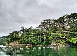
The islet, which has a land area of 0.02 square kilometres (4.9 acres), a circumference of 0.9 km and a height of 25 meters, is located within the municipality of
47:
324:
399:
404:
303:
The island was owned by
Shibuya Kasuke, a local businessman who made his fortune importing gunpowder and munitions during the
133:
360:
409:
320:
316:
296:, such that in autumn the red leaves and red tree trunks give the island the appearance of being made of
203:
273:
269:
242:
220:
308:
293:
289:
208:
215:
297:
393:
356:
265:
121:
304:
384:
285:
148:
135:
300:. It was designated as a national scenic spot for its beautiful scenery.
312:
33:
264:
in an uninhabited islet located in the center of Ōfunato Bay, on the
311:
for use as a public park. The island suffered from damage caused by
231:
226:
214:
202:
188:
180:
172:
164:
127:
117:
112:
21:
337:List of Places of Scenic Beauty of Japan (Iwate)
307:. It was donated to Ōfunato village during the
292:. It is covered in a dense forest of maple and
257:
268:of Japan. It has been designated a National
8:
16:
32:
15:
415:Tourist attractions in Iwate Prefecture
348:
385:Cultural Treasures of Iwate Prefecture
168:0.02 km (0.0077 sq mi)
7:
325:2011 Tōhoku earthquake and tsunami
14:
87:
54:
243:National Palace of Scenic Beauty
86:
79:
53:
46:
1:
70:Show map of Iwate Prefecture
400:Islands of Iwate Prefecture
361:Agency for Cultural Affairs
431:
176:0.9 km (0.56 mi)
258:
239:
193:
40:
31:
321:1960 Valdivia earthquake
405:Places of Scenic Beauty
317:1933 Sanriku earthquake
270:Place of Scenic Beauty
184:25 m (82 ft)
181:Highest elevation
149:39.03694°N 141.72722°E
154:39.03694; 141.72722
145: /
18:
294:Japanese red pine
250:
249:
103:Show map of Japan
100:Sangojima (Japan)
422:
372:
371:
369:
367:
353:
290:Iwate Prefecture
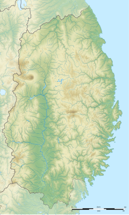
274:Natural Monument
263:
261:
260:
160:
159:
157:
156:
155:
150:
146:
143:
142:
141:
138:
104:
90:
89:
83:
71:
57:
56:
50:
36:
19:
430:
429:
425:
424:
423:
421:
420:
419:
390:
389:
381:
376:
375:
365:
363:
355:
354:
350:
345:
333:
282:
255:
246:
245:
198:
153:
151:
147:
144:
139:
136:
134:
132:
131:
108:
107:
106:
105:
102:
101:
98:
97:
96:
95:
91:
74:
73:
72:
69:
68:
65:
64:
63:
62:
58:
27:
26:
12:
11:
5:
428:
426:
418:
417:
412:
410:Ōfunato, Iwate
407:
402:
392:
391:
388:
387:
380:
379:External links
377:
374:
373:
347:
346:
344:
341:
340:
339:
332:
329:
281:
278:
248:
247:
241:
240:
237:
236:
233:
229:
228:
224:
223:
218:
212:
211:
206:
200:
199:
194:
191:
190:
189:Administration
186:
185:
182:
178:
177:
174:
170:
169:
166:
162:
161:
129:
125:
124:
119:
115:
114:
110:
109:
99:
93:
92:
85:
84:
78:
77:
76:
75:
66:
60:
59:
52:
51:
45:
44:
43:
42:
41:
38:
37:
29:
28:
24:
22:
13:
10:
9:
6:
4:
3:
2:
427:
416:
413:
411:
408:
406:
403:
401:
398:
397:
395:
386:
383:
382:
378:
362:
358:
352:
349:
342:
338:
335:
334:
330:
328:
326:
323:, and in the
322:
318:
314:
310:
309:Taishō period
306:
301:
299:
295:
291:
287:
279:
277:
275:
271:
267:
266:Sanriku Coast
254:
244:
238:
234:
230:
225:
222:
219:
217:
213:
210:
207:
205:
201:
197:
192:
187:
183:
179:
175:
171:
167:
163:
158:
130:
126:
123:
122:Pacific Ocean
120:
116:
111:
82:
49:
39:
35:
30:
23:Native name:
20:
364:. Retrieved
351:
305:Meiji period
302:
283:
276:since 1946.
252:
251:
227:Demographics
195:
152: /
140:141°43′38″E
128:Coordinates
394:Categories
343:References
232:Population
204:Prefecture
137:39°02′13″N
298:red coral
253:Sangojima
173:Coastline
113:Geography
94:Sangojima
67:Sangojima
61:Sangojima
17:Sangojima
366:10 April
331:See also
319:and the
315:in the
280:Overview
118:Location
313:tsunami
286:Ōfunato
221:Ōfunato
357:"珊琥島"
209:Iwate
196:Japan
368:2020
272:and
216:City
165:Area
259:珊琥島
25:珊琥島
396::
359:.
327:.
288:,
370:.
262:)
256:(
235:0
Text is available under the Creative Commons Attribution-ShareAlike License. Additional terms may apply.