458:
59:
160:
90:
42:
295:
Garland, and 30 miles (48 km) east of
Alamosa. The ranches are located in Costilla County. Forbes, Inc. developed this area and began selling lots in 1971 and finished the sales operation around 2000. There are slightly under 8000 lots ranging in size from 5 to 30 acres (120,000 m). The subdivision encompasses approximately 56,160 acres (227.3 km) of land, of which 4,624 acres (18.71 km) are devoted to Common Land.
180:
97:
66:
294:
Sangre de Cristo
Ranches is a private, rural subdivision located in the heart of the Sangre de Cristo Mountain range in Southern Colorado. It can be accessed from Route 160 at the eastern edge of the San Luis Valley, about 50 miles (80 km) west of Walsenburg, 1-mile (1.6 km) east of Fort
598:
391:
603:
89:
120:
58:
384:
304:
377:
41:
369:
279:
192:
401:
271:
197:
152:
568:
469:
477:
267:
249:
234:
213:
575:
482:
223:
532:
517:
492:
263:
32:
555:
447:
423:
527:
522:
512:
507:
442:
502:
592:
165:
416:
547:
331:
172:
135:
122:
204:
361:
326:
283:
275:
242:
185:
74:
457:
230:
209:
434:
335:
373:
456:
96:
65:
286:
81133) serves Sangre de Cristo
Ranches postal addresses.
599:
Unincorporated communities in
Costilla County, Colorado
104:
Sangre de Cristo
Ranches, Colorado (the United States)
546:
491:
468:
433:
241:
220:
203:
191:
171:
151:
23:
18:
Unincorporated community in
Colorado, United States
362:Sangre De Cristo Ranches Homeowners Association
340:. United States Postal Service. January 3, 2007
385:
8:
461:Map of Colorado highlighting Costilla County
392:
378:
370:
20:
321:
319:
315:
240:
202:
150:
115:
50:
38:
604:Unincorporated communities in Colorado
219:
190:
170:
7:
305:List of cities and towns in Colorado
400:Municipalities and communities of
25:Sangre de Cristo Ranches, Colorado
14:
178:
158:
95:
88:
64:
57:
40:
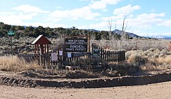
46:Signs at one of the entrances.
1:
107:Show map of the United States
620:
564:
454:
414:
403:Costilla County, Colorado
116:
73:Location in the state of
51:
39:
30:
538:Sangre de Cristo Ranches
264:unincorporated community
260:Sangre de Cristo Ranches
33:Unincorporated community
462:
278:, United States. The
136:37.38917°N 105.33611°W
460:
222: • Summer (
577:United States portal
141:37.38917; -105.33611
79:Show map of Colorado
132: /
463:
586:
585:
327:"ZIP Code Lookup"
282:at Fort Garland (
257:
256:
611:
578:
571:
459:
426:
419:
409:
404:
394:
387:
380:
371:
350:
349:
347:
345:
339:
323:
280:U.S. Post Office
227:
184:
182:
181:
164:
162:
161:
147:
146:
144:
143:
142:
137:
133:
130:
129:
128:
125:
108:
99:
98:
92:
80:
68:
67:
61:
44:
21:
619:
618:
614:
613:
612:
610:
609:
608:
589:
588:
587:
582:
576:
570:Colorado portal
569:
560:
542:
494:
487:
464:
452:
429:
424:
417:
410:
407:
402:
398:
367:
358:
353:
343:
341:
329:
325:
324:
317:
313:
301:
292:
272:Costilla County
253:
221:
198:Costilla County
179:
177:
159:
157:
140:
138:
134:
131:
126:
123:
121:
119:
118:
112:
111:
110:
109:
106:
105:
102:
101:
100:
83:
82:
81:
78:
77:
71:
70:
69:
47:
35:
26:
19:
12:
11:
5:
617:
615:
607:
606:
601:
591:
590:
584:
583:
581:
580:
573:
565:
562:
561:
559:
558:
552:
550:
544:
543:
541:
540:
535:
530:
525:
520:
515:
510:
505:
499:
497:
493:Unincorporated
489:
488:
486:
485:
480:
474:
472:
466:
465:
455:
453:
451:
450:
445:
439:
437:
431:
430:
415:
412:
411:
399:
397:
396:
389:
382:
374:
365:
364:
357:
356:External links
354:
352:
351:
314:
312:
309:
308:
307:
300:
297:
291:
288:
255:
254:
247:
245:
239:
238:
228:
218:
217:
207:
201:
200:
195:
189:
188:
175:
169:
168:
155:
149:
148:
114:
113:
103:
94:
93:
87:
86:
85:
84:
72:
63:
62:
56:
55:
54:
53:
52:
49:
48:
45:
37:
36:
31:
28:
27:
24:
17:
13:
10:
9:
6:
4:
3:
2:
616:
605:
602:
600:
597:
596:
594:
579:
574:
572:
567:
566:
563:
557:
554:
553:
551:
549:
545:
539:
536:
534:
531:
529:
526:
524:
521:
519:
516:
514:
511:
509:
506:
504:
501:
500:
498:
496:
490:
484:
481:
479:
476:
475:
473:
471:
467:
449:
446:
444:
441:
440:
438:
436:
432:
428:
427:
420:
413:
408:United States
405:
395:
390:
388:
383:
381:
376:
375:
372:
368:
363:
360:
359:
355:
337:
333:
328:
322:
320:
316:
310:
306:
303:
302:
298:
296:
289:
287:
285:
281:
277:
273:
269:
266:located near
265:
261:
251:
246:
244:
236:
232:
229:
225:
215:
211:
208:
206:
199:
196:
194:
187:
176:
174:
167:
166:United States
156:
154:
145:
117:Coordinates:
91:
76:
60:
43:
34:
29:
22:
16:
537:
478:Fort Garland
422:
366:
342:. Retrieved
293:
268:Fort Garland
259:
258:
250:Fort Garland
15:
495:communities
418:County seat
139: /
127:105°20′10″W
593:Categories
548:Ghost town
483:San Acacio
344:January 3,
332:JavaScript
311:References
124:37°23′21″N
533:San Pablo
518:La Valley
290:Geography
205:Time zone
556:Eastdale
448:San Luis
425:San Luis
299:See also
284:ZIP Code
276:Colorado
243:ZIP code
186:Colorado
75:Colorado
528:Russell
248:81133 (
153:Country
523:Mesita
513:Jaroso
508:Garcia
443:Blanca
262:is an
193:County
183:
163:
503:Chama
435:Towns
231:UTC-6
210:UTC-7
173:State
470:CDPs
346:2007
336:HTML
270:in
235:MDT
224:DST
214:MST
595::
421::
406:,
318:^
274:,
393:e
386:t
379:v
348:.
338:)
334:/
330:(
252:)
237:)
233:(
226:)
216:)
212:(
Text is available under the Creative Commons Attribution-ShareAlike License. Additional terms may apply.