394:
45:
969:
61:
349:
252:
267:
68:
328:
next to
Sargent Ranch, the station quickly became a stop on the Southern Pacific Railroad, facilitating the transport of goods and passengers and spurring economic growth in the surrounding area. Additionally, Sargent Hills and Sargent Creek are also located nearby to the west. Sargent was frequently
360:
In the late 1800s, Sargent became known as a popular resort and gathering for summer picnics along the Pajaro River. Its overhanging willows provided a cool, secluded area ideal for hunting, boating and fishing. Sargent was situated at the only bridge crossing of the Pajaro River for many miles. By
356:
Sargent developed into a community with cottages, a hotel, post office, saloon, an open-air dance floor, and a clubhouse near the station. The town's proximity to the railroad made it an ideal location for farmers to ship their produce. As a strategic stop on the line, Sargent
Station became a hub
381:
line. Around 1899, the
Watsonville Oil Company initiated oil extraction from the Sargent Ranch oil field. Tar, sourced from the tap springs along Monterey Road, was transported from Sargent Station to San José for use in street paving. By 1864, an oil and kerosene distillery was in operation at
357:
for both freight and passenger services. Farmers in the region relied on the station to transport their crops, such as wheat, barley, and fruits, to processing plants and larger markets. In 1895, shipments from
Sargent station consisted of hay, grain, fruit, cheese, butter, and eggs.
336:
By 1872, southern destinations could be reached daily by taking the passenger train to Gilroy, continuing to
Sargent's Station, and then proceeding by stagecoach. Mark Regan established a stage line that transported passengers from Sargent Station to
382:
Sargent. When the company ceased its activities in 1948, it had shipped 780,000 barrels of oil from the
Sargent station. This was the highest amount of oil produced by any oil field in the San Francisco Bay Area.
243:. The town is located at an elevation of 144 feet (44 m) above sea level. Founded in 1864 as a farming town, Sargent emerged during the booming railroad era, which enabled towns to develop along the tracks.
1212:
837:
320:(1823–1890), a rancher and assemblyman, bought Rancho Juristac with his brothers, where he established his residence, later known as Sargent Ranch. The establishment of the
1217:
385:
Although most of the
Sargent oil fields were situated about three miles west of Sargent, several wells were located just a quarter-mile west of the Sargent station.
1063:
529:
830:
401:
When the bridge across the Pajaro River was rebuilt and realigned in 1941, Sargent's
Station became inaccessible, and many of its buildings were abandoned.
60:
305:
area in 1776, and in 1797 Mission San Juan
Bautista was established near the Pajaro River. In 1835, Antonio and Faustino German were granted, by Governor
1222:
96:
44:
993:
823:
236:
880:
393:
1101:
711:
282:
1116:
491:
202:
1227:
465:
410:
815:
637:
810:
735:"County Of Santa Clara Historic Context Statement, County of Santa Clara Department of Planning and Development Planning Office"
584:
1078:
847:
374:
149:
144:
1139:
767:. Sacramento, California: California Department of Conservation, Division of Oil, Gas, and Geothermal Resources. p. 17.
378:
338:
224:
1121:
610:
289:. Today, most of the over 500 members of the Amah Mutsun band are descendants of the native people who were baptized at
1106:
1073:
1013:
908:
688:
1053:
734:
1182:
998:
933:
290:
373:
to San Jose. About 5.25 miles from
Sargent lies an active oil field known as the Sargent Oil Field, situated on
348:
1048:
1003:
923:
665:
444:
361:
1895, it was a favored spot for hunters and social groups from nearby cities like San Francisco and San Jose.
208:
1111:
1068:
980:
948:
928:
561:
Reports of Land Cases Determined in the United States District Court for the Northern District of California
1093:
1023:
1154:
1149:
1008:
988:
958:
938:
913:
903:
893:
342:
310:
294:
194:
763:
David L. Wagner; Bill Fedasko; J.R. Carnahan; Ross Brunetti; Leslie B. Magoon; Paul G. Lillis (2002).
1189:
1028:
953:
943:
918:
888:
869:
317:
183:
1169:
1159:
1083:
1038:
420:
81:
1058:
1018:
898:
302:
232:
228:
707:
461:
173:
1144:
689:
Visit to Sargent Station, Alameda Daily Argus, Alameda, California, Wednesday, June 1, 1887
330:
321:
313:
275:
255:
306:
240:
492:"Federal Recognition Of Native American Tribes: The Case Of California's Amah Mustsun"
1206:
370:
325:
458:
California's Geographic Names: A Gazetteer of Historic and Modern Names of the State
286:
259:
251:
701:
559:
862:
779:
642:. Valley Publishers/San Juan Bautista Historical Society. pp. 138–139, 174
445:
U.S. Geological Survey Geographic Names Information System: Sargent, California
266:
1131:
298:
220:
35:
764:
190:
169:
111:
98:
742:
County of Santa Clara Department of Planning and Development Planning Office
415:
164:
703:
East of the Gabilans The Ranches, the Towns, the People—yesterday and Today
670:. Berkeley, California: San Jose Mercury Pub. & Print. Company. 1895
765:"Tar Creek study, Sargent oil, field, Santa Clara County, California"
279:
397:
The beet-loading tower sitting beside the abandoned spur at Sargent
324:
in 1869 marked the beginning of the town's prominence. Located off
392:
347:
265:
250:
227:. Most of the town lies on the north side of the county line in
819:
369:
Sargent played an important role in oil transportation along
967:
617:. San Francisco, California. March 9, 1872. p. 2
1213:
Former settlements in Santa Clara County, California
1130:
1092:
1037:
979:
879:
591:. San Francisco: Alley, Bowen & Co. p. 628
460:. Clovis, Calif.: Word Dancer Press. p. 1045.
201:
180:
163:
155:
143:
135:
127:
26:
274:Before the Spanish colonizers arrived to settle
223:in central California, located on the border of
968:
831:
231:, approximately 5 miles (8 km) south of
8:
811:Santa Clara County And its Resources (1896)
706:. Western Tanager Press. pp. 150–152.
639:Early Days at the Mission San Juan Bautista
524:
522:
520:
518:
516:
838:
824:
816:
23:
1218:Ghost towns in the San Francisco Bay Area
659:
657:
589:History of Santa Clara County, California
329:mentioned as the western boundary of the
84:##Location within the state of California
432:
352:Group at Post Office at Sargent Station
162:
154:
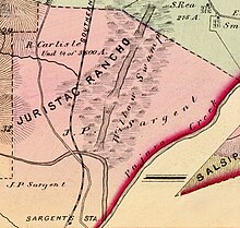
126:
91:
53:
41:
21:Ghost town in California, United States
485:
483:
481:
479:
477:
440:
438:
436:
270:Sargent Station in Sargent, California
200:
179:
142:
134:
7:
667:Santa Clara County and Its Resources
636:Mylar, Isaac L. (January 1, 1976).
846:Municipalities and communities of
14:
611:"Paso Robles Hot Sulphur Springs"
411:List of ghost towns in California
258:Map showing J. P. Sargent ranch,
16:City in California, United States
1223:Ghost towns in the United States
309:, the 4,540-acre (18.4 km)
66:
59:
43:
537:San Francisco Estuary Institute
67:
849:Santa Clara County, California
530:"Local Landscape Descriptions"
1:
285:inhabited villages along the
278:in 1769, approximately 2,700
225:San Benito County, California
583:Munro-Fraser, J. P. (1881).
564:. San Francisco: Numa Hubert
293:. Spanish explorers led by
1244:
615:The San Francisco Examiner
1228:Ghost towns in California
1178:
965:
860:
700:Pierce, Marjorie (1981).
490:Hart, Richard E. (2019).
456:Durham, David L. (1998).
301:first passed through the
291:Mission San Juan Bautista
283:Native Americans speakers
237:Southern Pacific Railroad
92:
54:
42:
33:
1117:South Santa Clara Valley
585:"Hon. James P. Sargent"
558:Hoffman, Ogden (1862).
499:www.protectjuristac.org
159:144 ft (44 m)
973:
972:Santa Clara County map
398:
353:
271:
263:
112:36.91944°N 121.54806°W
971:
396:
351:
295:Juan Bautista de Anza
269:
262:, and Sargent station
254:
182: • Summer (
1191:United States portal
664:"Sargents Station".
318:James Pattee Sargent
239:track, just west of
117:36.91944; -121.54806
780:"Sargent's Station"
421:Old field (ecology)
108: /
82:Northern California
49:Sargent, California
1079:San Antonio Valley
974:
778:Patrick McGreevy.
539:. pp. 199–200
399:
389:Decline and legacy
377:just north of the
354:
311:Mexican land grant
303:Santa Clara Valley
272:
264:
229:Santa Clara County
1200:
1199:
1184:California portal
713:978-0-934136-11-2
379:Santa Cruz County
365:Sargent oil field
214:
213:
1235:
1192:
1185:
1122:West Santa Clara
970:
881:Cities and towns
872:
865:
855:
850:
840:
833:
826:
817:
798:
797:
795:
793:
784:
775:
769:
768:
760:
754:
753:
751:
749:
739:
731:
725:
724:
722:
720:
697:
691:
686:
680:
679:
677:
675:
661:
652:
651:
649:
647:
633:
627:
626:
624:
622:
607:
601:
600:
598:
596:
580:
574:
573:
571:
569:
555:
549:
548:
546:
544:
534:
526:
511:
510:
508:
506:
501:. pp. 66–67
496:
487:
472:
471:
453:
447:
442:
187:
123:
122:
120:
119:
118:
113:
109:
106:
105:
104:
101:
80:Location within
70:
69:
63:
47:
24:
1243:
1242:
1238:
1237:
1236:
1234:
1233:
1232:
1203:
1202:
1201:
1196:
1190:
1183:
1174:
1140:Agnew's Village
1126:
1107:Lexington Hills
1088:
1074:Redwood Estates
1040:
1033:
1014:Lexington Hills
975:
963:
909:Los Altos Hills
875:
870:
863:
856:
853:
848:
844:
807:
802:
801:
791:
789:
782:
777:
776:
772:
762:
761:
757:
747:
745:
744:. December 2004
737:
733:
732:
728:
718:
716:
714:
699:
698:
694:
687:
683:
673:
671:
663:
662:
655:
645:
643:
635:
634:
630:
620:
618:
609:
608:
604:
594:
592:
582:
581:
577:
567:
565:
557:
556:
552:
542:
540:
532:
528:
527:
514:
504:
502:
494:
489:
488:
475:
468:
455:
454:
450:
443:
434:
429:
407:
391:
367:
322:Sargent Station
314:Rancho Juristac
276:Alta California
256:Rancho Juristac
249:
181:
116:
114:
110:
107:
102:
99:
97:
95:
94:
88:
87:
86:
85:
78:
77:
76:
75:
71:
50:
38:
29:
28:City of Sargent
22:
17:
12:
11:
5:
1241:
1239:
1231:
1230:
1225:
1220:
1215:
1205:
1204:
1198:
1197:
1195:
1194:
1187:
1179:
1176:
1175:
1173:
1172:
1167:
1162:
1157:
1152:
1147:
1142:
1136:
1134:
1128:
1127:
1125:
1124:
1119:
1114:
1109:
1104:
1098:
1096:
1090:
1089:
1087:
1086:
1081:
1076:
1071:
1066:
1061:
1056:
1054:Chemeketa Park
1051:
1045:
1043:
1039:Unincorporated
1035:
1034:
1032:
1031:
1026:
1021:
1016:
1011:
1006:
1004:East Foothills
1001:
996:
991:
985:
983:
977:
976:
966:
964:
962:
961:
956:
951:
946:
941:
936:
931:
926:
921:
916:
911:
906:
901:
896:
891:
885:
883:
877:
876:
861:
858:
857:
845:
843:
842:
835:
828:
820:
814:
813:
806:
805:External links
803:
800:
799:
770:
755:
726:
712:
692:
681:
653:
628:
602:
575:
550:
512:
473:
466:
448:
431:
430:
428:
425:
424:
423:
418:
413:
406:
403:
390:
387:
366:
363:
248:
245:
212:
211:
206:
199:
198:
188:
178:
177:
167:
161:
160:
157:
153:
152:
147:
141:
140:
137:
133:
132:
129:
125:
124:
90:
89:
79:
73:
72:
65:
64:
58:
57:
56:
55:
52:
51:
48:
40:
39:
34:
31:
30:
27:
20:
15:
13:
10:
9:
6:
4:
3:
2:
1240:
1229:
1226:
1224:
1221:
1219:
1216:
1214:
1211:
1210:
1208:
1193:
1188:
1186:
1181:
1180:
1177:
1171:
1168:
1166:
1163:
1161:
1158:
1156:
1153:
1151:
1148:
1146:
1143:
1141:
1138:
1137:
1135:
1133:
1129:
1123:
1120:
1118:
1115:
1113:
1110:
1108:
1105:
1103:
1100:
1099:
1097:
1095:
1091:
1085:
1082:
1080:
1077:
1075:
1072:
1070:
1067:
1065:
1064:Mountain Home
1062:
1060:
1057:
1055:
1052:
1050:
1047:
1046:
1044:
1042:
1036:
1030:
1027:
1025:
1022:
1020:
1017:
1015:
1012:
1010:
1007:
1005:
1002:
1000:
999:Cambrian Park
997:
995:
992:
990:
987:
986:
984:
982:
978:
960:
957:
955:
952:
950:
947:
945:
942:
940:
937:
935:
934:Mountain View
932:
930:
927:
925:
922:
920:
917:
915:
912:
910:
907:
905:
902:
900:
897:
895:
892:
890:
887:
886:
884:
882:
878:
874:
873:
866:
859:
854:United States
851:
841:
836:
834:
829:
827:
822:
821:
818:
812:
809:
808:
804:
788:
781:
774:
771:
766:
759:
756:
743:
736:
730:
727:
715:
709:
705:
704:
696:
693:
690:
685:
682:
669:
668:
660:
658:
654:
641:
640:
632:
629:
616:
612:
606:
603:
590:
586:
579:
576:
563:
562:
554:
551:
538:
531:
525:
523:
521:
519:
517:
513:
500:
493:
486:
484:
482:
480:
478:
474:
469:
467:1-884995-14-4
463:
459:
452:
449:
446:
441:
439:
437:
433:
426:
422:
419:
417:
414:
412:
409:
408:
404:
402:
395:
388:
386:
383:
380:
376:
372:
371:Monterey Road
364:
362:
358:
350:
346:
344:
340:
334:
332:
327:
326:Monterey Road
323:
319:
315:
312:
308:
304:
300:
296:
292:
288:
284:
281:
277:
268:
261:
257:
253:
246:
244:
242:
238:
234:
230:
226:
222:
218:
210:
207:
204:
196:
192:
189:
185:
175:
174:Pacific (PST)
171:
168:
166:
158:
151:
148:
146:
138:
131:United States
130:
121:
93:Coordinates:
83:
62:
46:
37:
32:
25:
19:
1164:
1102:Diablo Range
1049:Bell Station
924:Monte Sereno
868:
790:. Retrieved
786:
773:
758:
746:. Retrieved
741:
729:
717:. Retrieved
702:
695:
684:
672:. Retrieved
666:
644:. Retrieved
638:
631:
619:. Retrieved
614:
605:
593:. Retrieved
588:
578:
566:. Retrieved
560:
553:
541:. Retrieved
536:
503:. Retrieved
498:
457:
451:
400:
384:
368:
359:
355:
335:
333:floodplain.
287:Pajaro River
273:
260:Pajaro Creek
235:, along the
216:
215:
18:
1132:Ghost towns
1112:Llagas-Uvas
1069:New Almaden
1041:communities
949:Santa Clara
929:Morgan Hill
864:County seat
787:core.ac.uk/
416:Lost cities
307:José Castro
191:UTC−7
170:UTC−8
150:Santa Clara
115: /
103:121°32′53″W
1207:Categories
1024:San Martin
427:References
316:. In 1856
299:Pedro Font
221:ghost town
205:feature ID
139:California
100:36°55′10″N
36:Ghost town
1155:Lexington
1150:Holy City
1009:Fruitdale
989:Alum Rock
959:Sunnyvale
939:Palo Alto
914:Los Gatos
904:Los Altos
894:Cupertino
375:Tar Creek
343:Hollister
331:Soap Lake
165:Time zone
156:Elevation
1029:Stanford
954:Saratoga
944:San Jose
919:Milpitas
889:Campbell
871:San Jose
405:See also
339:San Juan
241:U.S. 101
1170:Wrights
1165:Sargent
1160:Patchen
1084:Sveadal
994:Burbank
792:May 31,
748:May 30,
719:May 16,
674:May 24,
646:May 21,
621:May 22,
595:May 16,
568:May 31,
543:May 16,
505:May 21,
247:History
217:Sargent
209:1656278
128:Country
74:Sargent
1059:Coyote
1019:Loyola
899:Gilroy
710:
464:
280:Mutsun
233:Gilroy
145:County
783:(PDF)
738:(PDF)
533:(PDF)
495:(PDF)
219:is a
136:State
1145:Alma
1094:CCDs
981:CDPs
794:2024
750:2024
721:2024
708:ISBN
676:2024
648:2024
623:2024
597:2024
570:2024
545:2024
507:2024
462:ISBN
341:and
297:and
203:GNIS
195:PDT
184:DST
1209::
867::
852:,
785:.
740:.
656:^
613:.
587:.
535:.
515:^
497:.
476:^
435:^
345:.
839:e
832:t
825:v
796:.
752:.
723:.
678:.
650:.
625:.
599:.
572:.
547:.
509:.
470:.
197:)
193:(
186:)
176:)
172:(
Text is available under the Creative Commons Attribution-ShareAlike License. Additional terms may apply.