839:
31:
48:
84:
1448:
91:
55:
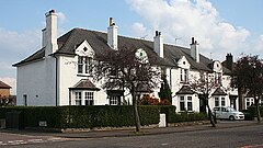
425:' mix, comprising four-in-a-block apartments with the upper flats accessed via a common stairway in the middle of the building, two-level homes in terrace rows, and detached bungalows. Modern properties have sporadically filled most spaces which once existed. There is an eponymous community association with its own premises and orchard, and a
197:
405:
and
Ellersley Road known as Western Corner (at this point Corstorphine Road has the secondary name of Western Terrace) towards the mansion, and most secondary streets also took this name. A convenience store is situated at the other end of Saughtonhall Drive where it forms a V-junction with the
463:
As of the early 2020s, the neighbourhood was split in terms of catchment zones for both public schooling paths, though along different divisions: the majority of streets are allocated to non-denominational
Balgreen Primary (feeding to
400:
when the city expanded amid housing reform. An explanation is that the main thoroughfare in the area was named
Saughtonhall Drive when it was laid out due to it running south-west from its origin at the crossroads of
429:
which has been in situ since the neighbourhood's establishment in 1929. In the north of the area in close proximity to one another on
Saughton Crescent are two nursery schools, a medical centre and a
255:
433:; there is also a larger clinic on Corstophine Road. In addition to the rugby stadia, golf course and public parks, there is are clubs for tennis (Murrayfield, dating from 1904) and
237:
263:
687:
472:), while for Catholic education the northern streets are allocated to Fox Covert Primary but the southern streets are allocated to St Cuthbert's Primary (both feeding to
221:
550:
47:
1489:
673:
245:
838:
473:
452:; to the north, several bus routes run along Corstorphine Road. In the mid 20th century, there were train stations to the north-west and south at
183:
392:
Although named after
Saughton Hall, a local historic country house, the neighbourhood is not located where the mansion stood – that was at
348:), Carrick Knowe golf course to the west (bounded by the route of the Corstorphine Branch railway which is now a section of the pedestrian
538:
209:
296:
1513:
625:
507:
523:
637:
83:
1482:
666:
281:
214:
127:
377:
171:
137:
68:
457:
511:
30:
1508:
1475:
659:
824:
286:
226:
396:
about 0.5 miles (0.80 km) to the south, while the area that became
Saughtonhall was farmland until after the
609:
381:
453:
151:
119:
651:
376:
to the east, connected by several footbridges which now also incorporate flooding defences. It is within the
970:
361:
1346:
945:
786:
469:
465:
373:
1251:
1049:
995:
811:
796:
781:
751:
716:
1218:
1174:
1164:
1119:
1104:
1000:
985:
960:
920:
915:
885:
865:
776:
746:
721:
426:
357:
1321:
1266:
1154:
1144:
1139:
1039:
1005:
990:
965:
955:
930:
353:
1428:
1351:
1301:
1213:
1159:
1054:
791:
771:
711:
527:
496:
402:
345:
492:
1326:
1079:
756:
176:
1447:
445:
415:
397:
202:
1459:
1094:
369:
586:
1502:
1184:
1109:
1074:
890:
613:
449:
422:
393:
349:
1336:
1271:
1246:
1084:
731:
410:
further south. A prominent landmark at that junction is the 1920s depository for
1398:
1380:
1316:
1286:
1241:
1179:
1059:
925:
900:
880:
875:
870:
860:
766:
741:
736:
341:
1341:
1306:
1296:
1291:
1261:
1236:
1226:
1129:
1124:
1114:
980:
950:
905:
434:
444:
The closest public transport connection in the south of the neighbourhood is
311:
298:
1455:
1411:
1385:
1356:
1331:
1311:
1169:
935:
910:
816:
801:
726:
706:
683:
574:
468:) but those in the north-east are allocated to Roseburn Primary (feeding to
333:
161:
1390:
1276:
1208:
1149:
1089:
1064:
1029:
975:
895:
562:
407:
365:
337:
143:
104:
1256:
1134:
1034:
940:
438:
411:
524:
Edinburgh, Corstorphine Road, Statue Of Alan Breck & David
Balfour
1281:
1099:
1069:
1044:
806:
430:
1231:
761:
448:'s Balgreen stop, beyond which Gorgie Road is a busy corridor for
551:
spw040202 SCOTLAND (1932). Saughtonhall
Housing Estate, Edinburgh
598:
655:
837:
418:. There is also a range of local shops at Western Corner.
406:
slightly older
Balgreen Road, which in turn continues to
1463:
640:, City of Edinburgh Council. Retrieved 11 January 2024
628:, City of Edinburgh Council. Retrieved 11 January 2024
421:
Housing in the area is primarily an inter-war period '
1369:
1197:
1018:
849:
695:
254:
236:
220:
208:
196:
182:
170:
160:
150:
136:
118:
23:
626:Non-denominational primary school catchment areas
539:Jenners Repository, 140 Balgreen Road, Edinburgh
332:is a residential neighbourhood in the west of
73:Show map of the City of Edinburgh council area
1483:
667:
638:Roman Catholic primary school catchment areas
8:
599:Welcome to Balgreen Croquet and Bowling Club
368:cricket ground) on the opposite bank of the
1490:
1476:
1373:
1201:
1022:
853:
699:
674:
660:
652:
441:(Balgreen) at either end of Saughtonhall.
20:
587:History of Murrayfield Lawn Tennis Club
485:
235:
191:
159:
135:
27:
344:to the north (on the opposite side of
340:directly to the south and south-west,
610:Network Map including Edinburgh Trams
253:
219:
207:
195:
181:
169:
149:
117:
35:Terraced houses on Saughtonhall Drive
7:
1444:
1442:
565:, Saughtonhall Community Association
352:), and sports facilities (including
90:
54:
14:
1446:
89:
82:
53:
46:
29:
510:, Explore Georeferenced Maps (
493:Edinburgh, (Old) Saughton Hall
69:City of Edinburgh council area
1:
842:Edinburgh's Old and New Towns
378:Corstorphine/Murrayfield ward
1462:. You can help Knowledge by
589:Murrayfield Lawn Tennis Club
512:National Library of Scotland
508:OS 25 Inch, 1914 (Edinburgh)
18:Human settlement in Scotland
616:. Retrieved 11 January 2024
1530:
1441:
541:, British Listed Buildings
474:St Augustine's High School
1514:Edinburgh geography stubs
1424:
1376:
1204:
1025:
856:
835:
702:
682:Residential areas in the
414:department store, itself
382:City of Edinburgh Council
272:
232:
192:
40:
28:
926:Hillside and Calton Hill
256:Scottish Parliament
362:Edinburgh Rugby Stadium
1458:location article is a
843:
470:Craigmount High School
466:Tynecastle High School
346:Corstorphine Road (A8)
336:, Scotland, bordering
172:Postcode district
841:
752:Great Junction Street
553:, Britain from Above
427:United Reform Church
358:Murrayfield Ice Rink
312:55.94151°N 3.24911°W
152:Sovereign state
109:Show map of Scotland
67:Location within the
354:Murrayfield Stadium
308: /
1509:Areas of Edinburgh
1429:Areas of Edinburgh
844:
577:, Saughtonhall URC
317:55.94151; -3.24911
264:Edinburgh Central
238:UK Parliament
184:Dialling code
1471:
1470:
1436:
1435:
1420:
1419:
1365:
1364:
1193:
1192:
1014:
1013:
833:
832:
416:Category B listed
408:Gorgie Road (A71)
403:Corstorphine Road
327:
326:
128:City of Edinburgh
120:Council area
1521:
1492:
1485:
1478:
1450:
1443:
1374:
1267:Davidson's Mains
1202:
1023:
854:
700:
676:
669:
662:
653:
641:
635:
629:
623:
617:
607:
601:
596:
590:
584:
578:
572:
566:
560:
554:
548:
542:
536:
530:
521:
515:
505:
499:
490:
323:
322:
320:
319:
318:
313:
309:
306:
305:
304:
301:
278:
146:
110:
103:Location within
93:
92:
86:
74:
57:
56:
50:
33:
21:
1529:
1528:
1524:
1523:
1522:
1520:
1519:
1518:
1499:
1498:
1497:
1496:
1439:
1437:
1432:
1416:
1361:
1189:
1010:
845:
829:
825:Western Harbour
691:
680:
650:
645:
644:
636:
632:
624:
620:
608:
604:
597:
593:
585:
581:
573:
569:
561:
557:
549:
545:
537:
533:
522:
518:
506:
502:
491:
487:
482:
446:Edinburgh Trams
398:First World War
390:
316:
314:
310:
307:
302:
299:
297:
295:
294:
293:
276:
268:
250:
142:
132:
114:
113:
112:
111:
108:
107:
101:
100:
99:
98:
94:
77:
76:
75:
72:
71:
65:
64:
63:
62:
58:
36:
19:
12:
11:
5:
1527:
1525:
1517:
1516:
1511:
1501:
1500:
1495:
1494:
1487:
1480:
1472:
1469:
1468:
1451:
1434:
1433:
1425:
1422:
1421:
1418:
1417:
1415:
1414:
1409:
1408:
1407:
1404:
1401:
1396:
1393:
1388:
1377:
1371:
1367:
1366:
1363:
1362:
1360:
1359:
1354:
1349:
1344:
1339:
1334:
1329:
1324:
1319:
1314:
1309:
1304:
1299:
1294:
1289:
1284:
1279:
1274:
1269:
1264:
1259:
1254:
1249:
1244:
1239:
1234:
1229:
1224:
1221:
1216:
1211:
1205:
1199:
1195:
1194:
1191:
1190:
1188:
1187:
1182:
1177:
1172:
1167:
1162:
1157:
1152:
1147:
1142:
1137:
1132:
1127:
1122:
1117:
1112:
1107:
1102:
1097:
1095:Fountainbridge
1092:
1087:
1082:
1077:
1072:
1067:
1062:
1057:
1052:
1047:
1042:
1037:
1032:
1026:
1020:
1016:
1015:
1012:
1011:
1009:
1008:
1003:
998:
993:
988:
983:
978:
973:
968:
963:
958:
953:
948:
943:
938:
933:
928:
923:
918:
913:
908:
903:
898:
893:
888:
883:
878:
873:
868:
863:
857:
851:
847:
846:
836:
834:
831:
830:
828:
827:
822:
819:
814:
809:
804:
799:
794:
789:
784:
779:
774:
769:
764:
759:
754:
749:
744:
739:
734:
729:
724:
719:
714:
709:
703:
697:
693:
692:
681:
679:
678:
671:
664:
656:
649:
648:External links
646:
643:
642:
630:
618:
602:
591:
579:
567:
555:
543:
531:
516:
500:
484:
483:
481:
478:
460:respectively.
389:
386:
370:Water of Leith
325:
324:
292:
291:
289:
284:
279:
277:List of places
273:
270:
269:
267:
266:
260:
258:
252:
251:
249:
248:
246:Edinburgh West
242:
240:
234:
233:
230:
229:
224:
218:
217:
212:
206:
205:
200:
194:
193:
190:
189:
186:
180:
179:
174:
168:
167:
164:
158:
157:
156:United Kingdom
154:
148:
147:
140:
134:
133:
131:
130:
124:
122:
116:
115:
102:
96:
95:
88:
87:
81:
80:
79:
78:
66:
60:
59:
52:
51:
45:
44:
43:
42:
41:
38:
37:
34:
26:
25:
17:
13:
10:
9:
6:
4:
3:
2:
1526:
1515:
1512:
1510:
1507:
1506:
1504:
1493:
1488:
1486:
1481:
1479:
1474:
1473:
1467:
1465:
1461:
1457:
1452:
1449:
1445:
1440:
1431:
1430:
1423:
1413:
1410:
1405:
1402:
1400:
1397:
1394:
1392:
1389:
1387:
1384:
1383:
1382:
1379:
1378:
1375:
1372:
1368:
1358:
1355:
1353:
1350:
1348:
1345:
1343:
1340:
1338:
1335:
1333:
1330:
1328:
1325:
1323:
1320:
1318:
1315:
1313:
1310:
1308:
1305:
1303:
1300:
1298:
1295:
1293:
1290:
1288:
1285:
1283:
1280:
1278:
1275:
1273:
1270:
1268:
1265:
1263:
1260:
1258:
1255:
1253:
1250:
1248:
1245:
1243:
1240:
1238:
1235:
1233:
1230:
1228:
1225:
1222:
1220:
1217:
1215:
1212:
1210:
1207:
1206:
1203:
1200:
1196:
1186:
1185:Wester Hailes
1183:
1181:
1178:
1176:
1173:
1171:
1168:
1166:
1163:
1161:
1158:
1156:
1153:
1151:
1148:
1146:
1143:
1141:
1138:
1136:
1133:
1131:
1128:
1126:
1123:
1121:
1118:
1116:
1113:
1111:
1110:Juniper Green
1108:
1106:
1103:
1101:
1098:
1096:
1093:
1091:
1088:
1086:
1083:
1081:
1078:
1076:
1075:Craiglockhart
1073:
1071:
1068:
1066:
1063:
1061:
1058:
1056:
1053:
1051:
1048:
1046:
1043:
1041:
1038:
1036:
1033:
1031:
1028:
1027:
1024:
1021:
1017:
1007:
1004:
1002:
999:
997:
994:
992:
989:
987:
984:
982:
979:
977:
974:
972:
969:
967:
964:
962:
959:
957:
954:
952:
949:
947:
944:
942:
939:
937:
934:
932:
929:
927:
924:
922:
919:
917:
914:
912:
909:
907:
904:
902:
899:
897:
894:
892:
891:Carrick Knowe
889:
887:
884:
882:
879:
877:
874:
872:
869:
867:
864:
862:
859:
858:
855:
852:
848:
840:
826:
823:
820:
818:
815:
813:
810:
808:
805:
803:
800:
798:
795:
793:
790:
788:
785:
783:
780:
778:
775:
773:
770:
768:
765:
763:
760:
758:
755:
753:
750:
748:
745:
743:
740:
738:
735:
733:
730:
728:
725:
723:
720:
718:
715:
713:
710:
708:
705:
704:
701:
698:
694:
689:
685:
677:
672:
670:
665:
663:
658:
657:
654:
647:
639:
634:
631:
627:
622:
619:
615:
614:Lothian Buses
611:
606:
603:
600:
595:
592:
588:
583:
580:
576:
571:
568:
564:
559:
556:
552:
547:
544:
540:
535:
532:
529:
525:
520:
517:
513:
509:
504:
501:
498:
494:
489:
486:
479:
477:
475:
471:
467:
461:
459:
458:Balgreen Halt
455:
451:
450:Lothian Buses
447:
442:
440:
436:
432:
428:
424:
423:garden suburb
419:
417:
413:
409:
404:
399:
395:
394:Saughton Park
387:
385:
383:
379:
375:
371:
367:
366:Roseburn Park
363:
359:
355:
351:
350:John Muir Way
347:
343:
339:
335:
331:
321:
290:
288:
285:
283:
280:
275:
274:
271:
265:
262:
261:
259:
257:
247:
244:
243:
241:
239:
231:
228:
225:
223:
216:
213:
211:
204:
201:
199:
187:
185:
178:
175:
173:
165:
163:
155:
153:
145:
141:
139:
129:
126:
125:
123:
121:
106:
85:
70:
49:
39:
32:
22:
16:
1464:expanding it
1453:
1438:
1426:
1370:East Lothian
1337:Silverknowes
1272:Dean Village
1247:Corstorphine
1085:Fairmilehead
971:Prestonfield
732:Craigentinny
690:) urban area
633:
621:
605:
594:
582:
570:
558:
546:
534:
519:
503:
488:
462:
443:
420:
391:
330:Saughtonhall
329:
328:
97:Saughtonhall
61:Saughtonhall
24:Saughtonhall
15:
1399:Monktonhall
1381:Musselburgh
1347:Stockbridge
1317:Murrayfield
1287:East Craigs
1242:Comely Bank
1180:The Calders
1060:Clovenstone
946:Morningside
901:Dumbiedykes
881:Burdiehouse
876:Bruntsfield
871:Braid Hills
861:Alnwickhill
787:Mountcastle
767:Leith Docks
747:Easter Road
742:Duddingston
737:Craigmillar
388:Description
374:its walkway
342:Murrayfield
315: /
1503:Categories
1427:See also:
1406:Stoneybank
1342:South Gyle
1307:Inverleith
1297:Gracemount
1292:Goldenacre
1262:Crewe Toll
1252:Craigleith
1237:Clermiston
1227:Canonmills
1198:North West
1130:Murrayburn
1125:Merchiston
1115:Kingsknowe
1050:Broomhouse
1019:South West
996:The Grange
981:Southhouse
951:Mortonhall
906:Fernieside
850:South East
821:Willowbrae
812:Portobello
797:Northfield
782:Meadowbank
717:Bonnington
696:North East
688:settlement
480:References
435:lawn bowls
431:scout hall
380:under the
300:55°56′29″N
1456:Edinburgh
1412:Wallyford
1395:Levenhall
1386:Fisherrow
1357:Warriston
1332:Ravelston
1312:Muirhouse
1219:Blackhall
1175:Stenhouse
1170:Slateford
1165:Sighthill
1120:Longstone
1105:Greenhill
1001:Tollcross
986:Southside
961:Newington
936:Marchmont
921:Haymarket
916:Greenbank
911:Gilmerton
886:Canongate
866:Blackford
817:Restalrig
802:Piershill
777:Magdalene
727:Brunstane
722:Broughton
707:Abbeyhill
684:Edinburgh
334:Edinburgh
303:3°14′57″W
222:Ambulance
166:EDINBURGH
162:Post town
1391:Inveresk
1322:Newhaven
1277:Drumbrae
1209:Balgreen
1155:Saughton
1150:Roseburn
1145:Polwarth
1140:Parkhead
1090:Firrhill
1065:Colinton
1040:Bankhead
1030:Baberton
1006:West End
991:The Inch
976:Sciennes
966:Old Town
956:New Town
931:Liberton
896:Comiston
575:About Us
454:Pinkhill
338:Balgreen
287:Scotland
227:Scottish
215:Scottish
203:Scotland
144:Scotland
105:Scotland
1352:Trinity
1302:Granton
1257:Cramond
1223:Boswall
1214:Barnton
1160:Shandon
1135:Oxgangs
1055:Chesser
1035:Balerno
941:Moredun
792:Niddrie
772:Lochend
712:Bingham
528:Canmore
497:Canmore
439:croquet
412:Jenners
138:Country
1403:Pinkie
1327:Pilton
1282:Drylaw
1100:Gorgie
1070:Currie
1045:Bonaly
807:Pilrig
198:Police
1454:This
1232:Cammo
1080:Dalry
762:Leith
757:Joppa
1460:stub
563:Home
456:and
372:and
364:and
210:Fire
188:0131
177:EH12
476:).
1505::
612:,
526:,
495:,
437:/
384:.
360:,
356:,
282:UK
1491:e
1484:t
1477:v
1466:.
686:(
675:e
668:t
661:v
514:)
Text is available under the Creative Commons Attribution-ShareAlike License. Additional terms may apply.