138:
145:
26:
416:
137:
411:
94:
368:
406:
386:
87:
248:
31:
369:
Map service of the
Landscape Information System of the Rhineland-Palatinate Nature Conservation Office (
318:
The area surrounding of
Schwarzer Mann is a well-developed hiking area and the largest skiing area in
319:
291:
166:
283:
stream, on the eastern mountainside, the
Litzenmehlenbach and on its southern slopes, the Mönbach.
295:
69:
60:
252:
280:
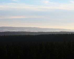
271:; the boundary between Buchet and Sellerich runs over the top. In the vicinity is the town of
264:
256:
335:
162:
25:
182:
400:
391:
240:
215:
211:
260:
346:
The name of the mountain is derived from the nearby abandoned lead ore mine in
275:
to the southeast as well as the villages of
Bleialf to the west-southwest and
35:
109:
96:
307:
268:
189:
75:
347:
272:
244:
170:
331:
276:
158:
53:
279:
to the northeast. On the northern slopes of the mountain rises the
294:(1752–1815), who undertook a survey of the Rhinelands by order of
219:
207:
193:
290:. This small boundary stone was named after French geographer,
214:. With a height of 697.8 meters it is the highest peak in the
251:. Its mountain summit lies around 3 kilometres west of
334:
and is host to a number of rare wild species including the
350:
from which the miners would return with blackened faces.
330:
The heavily wooded mountain ridge is covered mainly with
42:
and the tower of the Schnee Eifel transmitter (mid-2006)
206:("Black Man") is a mountain in the western part of the
181:
125:
86:
68:
52:
47:
18:
255:(part of Buchet), 3.8 km west-northwest of
8:
417:Mountains and hills of Rhineland-Palatinate
364:
362:
15:
358:
239:rises in the west of the Eifel in the
144:
371:Naturschutzverwaltung Rheinland-Pfalz
7:
310:which is also 15-kilometers-long.
14:
412:Mountains and hills of the Eifel
143:
136:
24:
306:The Schwarzer Mann is made of
1:
59:697.8 m above
38:forest looking south to the
407:Mountains under 1000 metres
249:High Fens-Eifel Nature Park
433:
387:Skiing area Schwarzer Mann
82:– Schnee Eifel transmitter
392:Website of the city Pruem
218:and third highest in the
130:
23:
263:) and 3.3 km (each
286:Near the summit is the
243:, near the border with
110:50.256917°N 6.359917°E
320:Rhineland-Palatinate
292:Jean Joseph Tranchot
167:Rhineland-Palatinate
80:– winter sports area
115:50.256917; 6.359917
106: /
296:Napoleon Bonaparte
210:which is known as
48:Highest point
265:as the crow flies
200:
199:
424:
375:
366:
336:European wildcat
185:
147:
146:
140:
121:
120:
118:
117:
116:
111:
107:
104:
103:
102:
99:
64:(2,289 ft)
63:
28:
16:
432:
431:
427:
426:
425:
423:
422:
421:
397:
396:
383:
378:
367:
360:
356:
344:
328:
326:Flora and fauna
316:
304:
247:and within the
233:
228:
183:
177:
176:
175:
174:
173:
155:
154:
153:
152:
148:
114:
112:
108:
105:
100:
97:
95:
93:
92:
81:
79:
61:sea level (NHN)
58:
43:
12:
11:
5:
430:
428:
420:
419:
414:
409:
399:
398:
395:
394:
389:
382:
381:External links
379:
377:
376:
357:
355:
352:
343:
340:
327:
324:
315:
312:
303:
300:
237:Schwarzer Mann
232:
229:
227:
224:
204:Schwarzer Mann
198:
197:
187:
179:
178:
156:
151:Schwarzer Mann
150:
149:
142:
141:
135:
134:
133:
132:
131:
128:
127:
123:
122:
90:
84:
83:
72:
66:
65:
56:
50:
49:
45:
44:
40:Schwarzer Mann
30:View from the
29:
21:
20:
19:Schwarzer Mann
13:
10:
9:
6:
4:
3:
2:
429:
418:
415:
413:
410:
408:
405:
404:
402:
393:
390:
388:
385:
384:
380:
374:
372:
365:
363:
359:
353:
351:
349:
341:
339:
337:
333:
325:
323:
321:
313:
311:
309:
301:
299:
297:
293:
289:
288:Tranchotstein
284:
282:
278:
274:
270:
266:
262:
258:
254:
250:
246:
242:
238:
230:
225:
223:
221:
217:
213:
209:
205:
195:
191:
188:
186:
180:
172:
168:
164:
160:
139:
129:
124:
119:
91:
89:
85:
77:
73:
71:
67:
62:
57:
55:
51:
46:
41:
37:
33:
27:
22:
17:
370:
345:
329:
317:
305:
287:
285:
267:) north of
241:Schnee Eifel
236:
234:
216:Schnee Eifel
212:Schnee Eifel
203:
201:
184:Parent range
163:Bitburg-Prüm
161:-Halenfeld;
98:50°15′24.9″N
39:
32:Weißer Stein
261:Gondenbrett
113: /
101:6°21′35.7″E
88:Coordinates
401:Categories
354:References
74:– Highest
36:Zitterwald
308:quartzite
269:Sellerich
259:(part of
253:Halenfeld
226:Geography
190:Schneifel
126:Geography
76:Schneifel
54:Elevation
257:Wascheid
231:Location
348:Bleialf
302:Geology
281:Alfbach
245:Belgium
171:Germany
70:Listing
34:in the
332:spruce
277:Ormont
159:Buchet
78:summit
314:Usage
220:Eifel
208:Eifel
194:Eifel
157:Near
342:Name
273:Prüm
235:The
202:The
403::
361:^
338:.
322:.
298:.
222:.
169:,
165:,
373:)
196:)
192:(
Text is available under the Creative Commons Attribution-ShareAlike License. Additional terms may apply.