30:
38:
22:
827:
124:
includes a walk on Scout Scar in its "Miles without stiles" project for accessible routes, and describes it as "A short, steep walk to one of the best views across the entire southern lakes". This route, accessible for "robust pushchairs", leads from the car park to a viewpoint below the top of the
892:
897:
87:
78:, but the summit he describes is a lower summit at 764 feet (233 m), 270m south of the highest point. Wainwright's anticlockwise recommended route also includes
290:
868:
473:
422:
121:
887:
134:
902:
29:
861:
486:
172:
74:
100:
At the lower, southern, summit there is a shelter, locally known as "The
Mushroom". It was built in 1912 as a memorial to
297:
466:
138:
348:
37:
854:
568:
373:
728:
459:
142:
94:
21:
797:
83:
451:
763:
503:
407:
808:
768:
588:
603:
826:
792:
593:
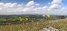
482:
167:
69:
838:
787:
718:
648:
578:
240:
215:
598:
380:
323:
120:
There is a car park in an old limestone quarry not far from the summit of Scout Scar. The
608:
658:
618:
558:
508:
881:
743:
708:
703:
673:
638:
533:
518:
296:. Lake District National Park Authority, Education Service. p. 3. Archived from
187:
109:
79:
53:
773:
713:
688:
653:
628:
563:
548:
265:
782:
698:
683:
678:
668:
663:
633:
583:
543:
513:
65:
733:
723:
643:
623:
553:
528:
68:. It reaches 771 feet (235 m). Scout Scar is the subject of a chapter of
437:
424:
409:
A Geological Walk from Kendal: Sites to visit on
Cunswick Scar and Scout Scar
778:
613:
573:
538:
105:
738:
523:
101:
834:
61:
137:
for their flora and fauna. In 2005 they were included in a multi-site
145:, which includes other limestone outcrops in Cumbria and Lancashire.
57:
104:, and restored in 1969 and again in 2003. The structure includes a
97:
and dip gently towards the east with a steep western scarp slope.
36:
28:
20:
82:
at 679 feet (207 m). The higher summit of Scout Scar has a
455:
893:
Mountains and hills of the United
Kingdom with toposcopes
842:
752:
494:
133:Scout and Cunswick Scars have been designated a
93:Scout Scar and Cunswick Scar are both formed of
898:Sites of Special Scientific Interest in Cumbria
33:"The Mushroom": memorial shelter on Scout Scar
862:
467:
90:, a hill with a prominence of at least 100m.
8:
176:. Kendal: Westmorland Gazette. pp. 2–7.
162:
160:
158:
869:
855:
474:
460:
452:
154:
122:Lake District National Park Authority
7:
823:
821:
349:"Miles Without Stiles 4: Scout Scar"
210:
208:
86:of 109m and is thus classified as a
135:Site of Special Scientific Interest
841:. You can help Knowledge (XXG) by
322:Griffin, Harry (20 October 2003).
41:Limestone vegetation on Scout Scar
14:
825:
809:Full list of Wainwrights by area
241:"Scout Scar (Wainwright summit)"
406:Dewey, Gillian; Michael Dewey.
324:"Country diary: One small step"
487:The Outlying Fells of Lakeland
173:The Outlying Fells of Lakeland
75:The Outlying Fells of Lakeland
1:
139:Special Area of Conservation
415:. Cumbria RIGS. p. 12.
353:Lake District National Park
52:, is a hill in the English
919:
888:Fells of the Lake District
820:
374:"Scout and Cunswick Scars"
806:
64:and above the village of
774:Devoke Water, Circuit of
16:Hill in Cumbria, England
903:Cumbria geography stubs
143:Morecambe Bay Pavements
95:Carboniferous Limestone
837:location article is a
798:Wet Sleddale Horseshoe
170:(1974). "Scout Scar".
84:topographic prominence
42:
34:
26:
112:and other landmarks.
40:
32:
24:
764:Bannisdale Horseshoe
755:for circuits, groups
438:54.32556°N 2.79028°W
769:Crookdale Horseshoe
589:Finsthwaite Heights
434: /
291:"Geology Factsheet"
604:Green Quarter Fell
497:for single summits
443:54.32556; -2.79028
303:on 21 October 2019
43:
35:
27:
850:
849:
815:
814:
793:Wasdale Horseshoe
910:
871:
864:
857:
829:
822:
788:Naddle Horseshoe
649:Knipescar Common
579:Dunnerdale Fells
476:
469:
462:
453:
449:
448:
446:
445:
444:
439:
435:
432:
431:
430:
427:
416:
414:
393:
392:
390:
388:
378:
370:
364:
363:
361:
359:
345:
339:
338:
336:
334:
319:
313:
312:
310:
308:
302:
295:
287:
281:
280:
278:
276:
262:
256:
255:
253:
251:
237:
231:
230:
228:
226:
212:
203:
202:
200:
198:
184:
178:
177:
164:
116:Accessible route
50:Underbarrow Scar
918:
917:
913:
912:
911:
909:
908:
907:
878:
877:
876:
875:
818:
816:
811:
802:
756:
754:
748:
599:Great Worm Crag
496:
490:
480:
442:
440:
436:
433:
428:
425:
423:
421:
420:
412:
405:
402:
397:
396:
386:
384:
381:Natural England
376:
372:
371:
367:
357:
355:
347:
346:
342:
332:
330:
321:
320:
316:
306:
304:
300:
293:
289:
288:
284:
274:
272:
266:"Cunswick Scar"
264:
263:
259:
249:
247:
239:
238:
234:
224:
222:
214:
213:
206:
196:
194:
186:
185:
181:
166:
165:
156:
151:
131:
118:
108:indicating the
17:
12:
11:
5:
916:
914:
906:
905:
900:
895:
890:
880:
879:
874:
873:
866:
859:
851:
848:
847:
830:
813:
812:
807:
804:
803:
801:
800:
795:
790:
785:
776:
771:
766:
760:
758:
757:and horseshoes
753:Chapters named
750:
749:
747:
746:
741:
736:
731:
726:
721:
716:
711:
706:
701:
696:
691:
686:
681:
676:
671:
666:
661:
659:Muncaster Fell
656:
651:
646:
641:
636:
631:
626:
621:
619:Heughscar Hill
616:
611:
606:
601:
596:
591:
586:
581:
576:
571:
566:
561:
559:Claife Heights
556:
551:
546:
541:
536:
531:
526:
521:
516:
511:
509:Bigland Barrow
506:
500:
498:
495:Chapters named
492:
491:
481:
479:
478:
471:
464:
456:
418:
417:
401:
400:External links
398:
395:
394:
365:
340:
314:
282:
257:
232:
204:
179:
168:Wainwright, A.
153:
152:
150:
147:
130:
127:
117:
114:
48:, also called
15:
13:
10:
9:
6:
4:
3:
2:
915:
904:
901:
899:
896:
894:
891:
889:
886:
885:
883:
872:
867:
865:
860:
858:
853:
852:
846:
844:
840:
836:
831:
828:
824:
819:
810:
805:
799:
796:
794:
791:
789:
786:
784:
780:
777:
775:
772:
770:
767:
765:
762:
761:
759:
751:
745:
744:Woodland Fell
742:
740:
737:
735:
732:
730:
727:
725:
722:
720:
719:Top o'Selside
717:
715:
712:
710:
709:Staveley Fell
707:
705:
704:Stainton Pike
702:
700:
697:
695:
692:
690:
687:
685:
682:
680:
677:
675:
674:Ponsonby Fell
672:
670:
667:
665:
662:
660:
657:
655:
652:
650:
647:
645:
642:
640:
639:Humphrey Head
637:
635:
632:
630:
627:
625:
622:
620:
617:
615:
612:
610:
607:
605:
602:
600:
597:
595:
592:
590:
587:
585:
582:
580:
577:
575:
572:
570:
567:
565:
562:
560:
557:
555:
552:
550:
547:
545:
542:
540:
539:Caermote Hill
537:
535:
532:
530:
527:
525:
522:
520:
519:Blawith Knott
517:
515:
512:
510:
507:
505:
502:
501:
499:
493:
489:
488:
484:
477:
472:
470:
465:
463:
458:
457:
454:
450:
447:
411:
410:
404:
403:
399:
382:
375:
369:
366:
354:
350:
344:
341:
329:
325:
318:
315:
299:
292:
286:
283:
271:
267:
261:
258:
246:
242:
236:
233:
221:
217:
211:
209:
205:
193:
189:
183:
180:
175:
174:
169:
163:
161:
159:
155:
148:
146:
144:
140:
136:
128:
126:
123:
115:
113:
111:
110:Central Fells
107:
103:
102:King George V
98:
96:
91:
89:
85:
81:
80:Cunswick Scar
77:
76:
71:
67:
63:
59:
55:
54:Lake District
51:
47:
39:
31:
23:
19:
843:expanding it
832:
817:
714:Stickle Pike
693:
689:School Knott
654:Latterbarrow
609:Gummer's How
564:Clints Crags
549:Cartmel Fell
485:
483:Wainwright's
419:
408:
385:. Retrieved
368:
356:. Retrieved
352:
343:
331:. Retrieved
328:The Guardian
327:
317:
305:. Retrieved
298:the original
285:
273:. Retrieved
269:
260:
248:. Retrieved
245:Hill Bagging
244:
235:
223:. Retrieved
220:Hill Bagging
219:
216:"Scout Scar"
195:. Retrieved
191:
188:"Scout Scar"
182:
171:
132:
119:
99:
92:
73:
70:Wainwright's
49:
45:
44:
18:
699:Seat Robert
684:Reston Scar
679:Potter Fell
669:Orrest Head
664:Newton Fell
634:Hugill Fell
584:Faulds Brow
544:Carron Crag
514:Black Combe
504:Beacon Fell
441: /
307:1 September
66:Underbarrow
882:Categories
734:Whitbarrow
729:Watch Hill
724:Walna Scar
694:Scout Scar
644:Irton Pike
624:High Knott
529:Brant Fell
426:54°19′32″N
358:26 October
149:References
129:Protection
56:, west of
46:Scout Scar
25:Scout Scar
779:Flat Fell
739:Whit Fell
614:Hesk Fell
594:Hampsfell
574:Dunmallet
569:Cold Fell
429:2°47′25″W
250:11 August
225:11 August
106:toposcope
524:Boat How
387:8 August
333:27 April
275:9 August
197:9 August
835:Cumbria
270:Peakery
192:Peakery
62:Cumbria
534:Burney
383:. 1989
125:scar.
58:Kendal
833:This
629:Howes
413:(PDF)
377:(PDF)
301:(pdf)
294:(PDF)
72:book
839:stub
783:Dent
781:and
389:2021
360:2013
335:2012
309:2012
277:2015
252:2015
227:2015
199:2015
88:HuMP
554:Caw
884::
379:.
351:.
326:.
268:.
243:.
218:.
207:^
190:.
157:^
141:,
60:,
870:e
863:t
856:v
845:.
475:e
468:t
461:v
391:.
362:.
337:.
311:.
279:.
254:.
229:.
201:.
Text is available under the Creative Commons Attribution-ShareAlike License. Additional terms may apply.