268:
33:
191:. There were 585 households, comprising 894 males and 795 females, giving a sex ratio of 1.12 males per female. The median age was 44.6 years (compared with 37.4 years nationally), with 315 people (18.7%) aged under 15 years, 246 (14.6%) aged 15 to 29, 870 (51.5%) aged 30 to 64, and 261 (15.5%) aged 65 or older.
239:
Of those at least 15 years old, 186 (13.5%) people had a bachelor's or higher degree, and 291 (21.2%) people had no formal qualifications. The median income was $ 35,600, compared with $ 31,800 nationally. 213 people (15.5%) earned over $ 70,000 compared to 17.2% nationally. The employment status of
248:
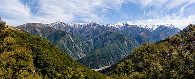
These mountains are characterised by tussock land, fellfields, and large areas of open scree, while lowland forests have largely been cleared. The
Spencer range to the south meanwhile has a more intact beech forest covering.
80:
at the southern extreme of the more eastern range, the
Seaward Kaikōuras. This range rises straight from (and dominates) the coast to the north of the town, and reaches its highest point with the 2,608-metre (8,556 ft)
274:
1257:
258:
267:
92:
separate the
Seaward Kaikōuras from the longer and loftier Inland Kaikōuras. This latter range contains the highest peak in the ranges, the 2,885-metre (9,465 ft)
1362:
1073:
415:
116:
and covers 2,037.57 km (786.71 sq mi). It had an estimated population of 1,860 as of June 2023, with a population density of 0.9 people per km.
1323:
1252:
1372:
349:
948:
857:
1066:
408:
984:
731:
296:
240:
those at least 15 was that 834 (60.7%) people were employed full-time, 246 (17.9%) were part-time, and 15 (1.1%) were unemployed.
216:
Although some people chose not to answer the census's question about religious affiliation, 51.3% had no religion, 36.6% were
827:
1247:
1000:
1367:
1059:
1005:
761:
746:
401:
1273:
979:
736:
802:
777:
721:
217:
1309:
1217:
1197:
958:
787:
89:
383:
BirdLife
International. (2012). Important Bird Areas factsheet: Kowhai Valley, Shearwater Stream. Downloaded from
898:
872:
842:
741:
644:
1237:
782:
61:
354:
104:, which runs parallel to that of the Waiau Toa / Clarence. The climate is characterised by a dry cold winter.
674:
233:
225:
203:
188:
184:
180:
48:
of New
Zealand. The two ranges are visible from a great distance, including from the southern coast of the
321:
1283:
609:
325:
32:
1113:
1095:
557:
544:
489:
479:
441:
437:
113:
1156:
1278:
1082:
913:
837:
629:
572:
529:
424:
229:
207:
100:
of which is the poetic "Footprint of the rainbow." Beyond the Inland Kaikōuras is the valley of the
706:
639:
514:
469:
1181:
953:
807:
562:
456:
82:
1151:
1025:
756:
664:
614:
221:
97:
1242:
963:
726:
711:
552:
1304:
918:
701:
654:
93:
1202:
199:
1166:
1010:
867:
822:
716:
519:
509:
499:
17:
1356:
1161:
1030:
1015:
893:
659:
596:
101:
65:
393:
1207:
862:
847:
797:
792:
592:
534:
49:
45:
1040:
1035:
1020:
504:
195:
1051:
213:
The percentage of people born overseas was 12.4, compared with 27.1% nationally.
1176:
1118:
1099:
1086:
903:
751:
577:
567:
428:
210:, and 2.3% other ethnicities. People may identify with more than one ethnicity.
77:
1299:
1212:
928:
923:
877:
832:
812:
634:
624:
524:
474:
73:
1338:
1325:
366:
1123:
852:
817:
649:
582:
484:
669:
604:
619:
464:
133:
494:
44:
are two parallel ranges of mountains located in the northeast of the
367:"Northern part of New Zealand's South Island – Ecoregions – WWF"
1128:
1055:
397:
352:. Statistics New Zealand. March 2020. Kaikōura Ranges (308800).
128:
384:
64:, they can be seen as the northernmost extension of the
1258:
Kowhai Valley and
Shearwater Stream Important Bird Area
259:
Kowhai Valley and
Shearwater Stream Important Bird Area
1292:
1266:
1230:
1190:
1144:
1137:
1106:
993:
972:
941:
886:
770:
694:
687:
591:
543:
455:
448:
187:, and an increase of 270 people (19.0%) since the
179:Kaikōura Ranges had a population of 1,689 at the
112:The statistical area of Kaikōura Ranges includes
1067:
409:
344:
342:
183:, an increase of 144 people (9.3%) since the
8:
350:"Statistical area 1 dataset for 2018 Census"
119:
27:Mountain range in South Island, New Zealand
1141:
1074:
1060:
1052:
691:
452:
416:
402:
394:
355:2018 Census place summary: Kaikōura Ranges
118:
1253:Ka Whata Tu O Rakihouia Conservation Park
732:Rangitoto ki te Tonga / D'Urville Island
76:, they take their name from the town of
31:
288:
322:"Population estimate tables - NZ.Stat"
88:The long straight river valley of the
1363:Landforms of the Marlborough District
277:View of Kaikōura Ranges from Mt Fyffe
7:
949:Long Island-Kokomohua Marine Reserve
25:
858:Queen Charlotte Sound / Tōtaranui
266:
194:Ethnicities were 89.5% European/
68:in the South Island. Named the
1373:Mountain ranges of New Zealand
828:Lake Grassmere / Kapara Te Hau
236:and 1.6% had other religions.
1:
747:Matapara / Pickersgill Island
1248:Kaikōura Dark Sky Sanctuary
803:Te Koko-o-Kupe / Cloudy Bay
722:Blumine Island / Ōruawairua
96:, the translation from the
60:Formed along New Zealand's
1389:
1231:Facilities and attractions
1218:Waiau Toa / Clarence River
1006:Te Atiawa o Te Waka-a-Māui
959:Mount Richmond Forest Park
942:Facilities and attractions
90:Waiau Toa / Clarence River
1300:1886 SS Taiaroa grounding
1093:
873:Tory Channel / Kura Te Au
853:Te Anamāhanga / Port Gore
843:Pelorus Sound / Te Hoiere
435:
172:
146:—
1310:2016 Kaikōura earthquake
1238:Hikurangi Marine Reserve
1031:Ngāti Tama ki Te Tau Ihu
297:"ArcGIS Web Application"
62:Marlborough Fault System
385:http://www.birdlife.org
301:statsnz.maps.arcgis.com
257:The ranges contain the
222:Māori religious beliefs
181:2018 New Zealand census
326:Statistics New Zealand
37:
18:Seaward Kaikōura Range
1001:Ngāti Apa ki te Rā Tō
120:Historical population
35:
1305:1978 Kaikoura lights
838:Meretoto / Ship Cove
425:Marlborough District
70:Looker-on mountains,
1335: /
1138:Geographic features
1041:Ngāti Toa Rangatira
707:Amerikiwhati Island
688:Geographic features
371:World Wildlife Fund
121:
1339:42.000°S 173.667°E
1157:Kaikōura Peninsula
1021:Rangitāne o Wairau
954:Molesworth Station
808:Croisilles Harbour
457:Marlborough Sounds
38:
1368:Kaikōura District
1318:
1317:
1226:
1225:
1083:Kaikōura District
1049:
1048:
937:
936:
757:Rangitoto Islands
683:
682:
615:Marlborough Ridge
177:
176:
16:(Redirected from
1380:
1350:
1349:
1347:
1346:
1345:
1344:-42.000; 173.667
1340:
1336:
1333:
1332:
1331:
1328:
1284:Regional Council
1274:District Council
1243:Kaikoura Airport
1142:
1107:Populated places
1076:
1069:
1062:
1053:
964:Rainbow Ski Area
727:Chetwode Islands
712:Anatakupu Island
692:
553:Blenheim Central
453:
449:Populated places
418:
411:
404:
395:
388:
381:
375:
374:
363:
357:
353:
346:
337:
336:
334:
332:
318:
312:
311:
309:
307:
293:
270:
135:
130:
122:
21:
1388:
1387:
1383:
1382:
1381:
1379:
1378:
1377:
1353:
1352:
1343:
1341:
1337:
1334:
1329:
1326:
1324:
1322:
1321:
1319:
1314:
1288:
1262:
1222:
1186:
1172:Kaikōura Ranges
1152:Kaikōura Canyon
1133:
1102:
1089:
1080:
1050:
1045:
989:
968:
933:
919:Tapuae-o-Uenuku
914:Richmond Ranges
909:Kaikōura Ranges
882:
771:Bodies of water
766:
762:Stephens Island
702:Allports Island
679:
655:Waihopai Valley
587:
539:
444:
431:
422:
392:
391:
382:
378:
365:
364:
360:
348:
347:
340:
330:
328:
320:
319:
315:
305:
303:
295:
294:
290:
285:
280:
279:
278:
276:
271:
255:
246:
110:
94:Tapuae-o-Uenuku
58:
42:Kaikōura Ranges
36:Kaikōura Ranges
28:
23:
22:
15:
12:
11:
5:
1386:
1384:
1376:
1375:
1370:
1365:
1355:
1354:
1316:
1315:
1313:
1312:
1307:
1302:
1296:
1294:
1290:
1289:
1287:
1286:
1281:
1276:
1270:
1268:
1264:
1263:
1261:
1260:
1255:
1250:
1245:
1240:
1234:
1232:
1228:
1227:
1224:
1223:
1221:
1220:
1215:
1210:
1205:
1200:
1194:
1192:
1188:
1187:
1185:
1184:
1179:
1174:
1169:
1167:Hundalee Hills
1164:
1159:
1154:
1148:
1146:
1139:
1135:
1134:
1132:
1131:
1126:
1121:
1116:
1110:
1108:
1104:
1103:
1094:
1091:
1090:
1081:
1079:
1078:
1071:
1064:
1056:
1047:
1046:
1044:
1043:
1038:
1033:
1028:
1023:
1018:
1013:
1008:
1003:
997:
995:
991:
990:
988:
987:
982:
976:
974:
970:
969:
967:
966:
961:
956:
951:
945:
943:
939:
938:
935:
934:
932:
931:
926:
921:
916:
911:
906:
901:
896:
890:
888:
884:
883:
881:
880:
875:
870:
868:Tennyson Inlet
865:
860:
855:
850:
845:
840:
835:
830:
825:
823:Kenepuru Sound
820:
815:
810:
805:
800:
795:
790:
785:
780:
774:
772:
768:
767:
765:
764:
759:
754:
749:
744:
739:
737:Forsyth Island
734:
729:
724:
719:
717:Arapaoa Island
714:
709:
704:
698:
696:
689:
685:
684:
681:
680:
678:
677:
672:
667:
662:
657:
652:
647:
642:
637:
632:
627:
622:
617:
612:
607:
601:
599:
589:
588:
586:
585:
580:
575:
570:
565:
560:
555:
549:
547:
541:
540:
538:
537:
532:
527:
522:
520:Port Underwood
517:
512:
510:Pelorus Bridge
507:
502:
497:
492:
487:
482:
477:
472:
467:
461:
459:
450:
446:
445:
436:
433:
432:
423:
421:
420:
413:
406:
398:
390:
389:
387:on 2012-02-18.
376:
358:
338:
313:
287:
286:
284:
281:
273:
272:
265:
264:
263:
254:
251:
245:
242:
175:
174:
170:
169:
166:
163:
159:
158:
155:
152:
148:
147:
144:
141:
137:
136:
131:
126:
109:
106:
57:
54:
26:
24:
14:
13:
10:
9:
6:
4:
3:
2:
1385:
1374:
1371:
1369:
1366:
1364:
1361:
1360:
1358:
1351:
1348:
1311:
1308:
1306:
1303:
1301:
1298:
1297:
1295:
1291:
1285:
1282:
1280:
1277:
1275:
1272:
1271:
1269:
1265:
1259:
1256:
1254:
1251:
1249:
1246:
1244:
1241:
1239:
1236:
1235:
1233:
1229:
1219:
1216:
1214:
1211:
1209:
1206:
1204:
1201:
1199:
1196:
1195:
1193:
1189:
1183:
1182:Mount Manakau
1180:
1178:
1175:
1173:
1170:
1168:
1165:
1163:
1162:Haumuri Bluff
1160:
1158:
1155:
1153:
1150:
1149:
1147:
1143:
1140:
1136:
1130:
1127:
1125:
1122:
1120:
1117:
1115:
1112:
1111:
1109:
1105:
1101:
1097:
1092:
1088:
1084:
1077:
1072:
1070:
1065:
1063:
1058:
1057:
1054:
1042:
1039:
1037:
1034:
1032:
1029:
1027:
1024:
1022:
1019:
1017:
1014:
1012:
1009:
1007:
1004:
1002:
999:
998:
996:
992:
986:
983:
981:
978:
977:
975:
971:
965:
962:
960:
957:
955:
952:
950:
947:
946:
944:
940:
930:
927:
925:
922:
920:
917:
915:
912:
910:
907:
905:
902:
900:
897:
895:
894:Cape Campbell
892:
891:
889:
885:
879:
876:
874:
871:
869:
866:
864:
861:
859:
856:
854:
851:
849:
846:
844:
841:
839:
836:
834:
831:
829:
826:
824:
821:
819:
816:
814:
811:
809:
806:
804:
801:
799:
796:
794:
791:
789:
786:
784:
781:
779:
778:Admiralty Bay
776:
775:
773:
769:
763:
760:
758:
755:
753:
750:
748:
745:
743:
740:
738:
735:
733:
730:
728:
725:
723:
720:
718:
715:
713:
710:
708:
705:
703:
700:
699:
697:
693:
690:
686:
676:
673:
671:
668:
666:
663:
661:
660:Wairau Valley
658:
656:
653:
651:
648:
646:
643:
641:
638:
636:
633:
631:
628:
626:
623:
621:
618:
616:
613:
611:
608:
606:
603:
602:
600:
598:
594:
590:
584:
581:
579:
576:
574:
571:
569:
566:
564:
561:
559:
556:
554:
551:
550:
548:
546:
542:
536:
533:
531:
528:
526:
523:
521:
518:
516:
513:
511:
508:
506:
503:
501:
498:
496:
493:
491:
488:
486:
483:
481:
478:
476:
473:
471:
468:
466:
463:
462:
460:
458:
454:
451:
447:
443:
439:
434:
430:
426:
419:
414:
412:
407:
405:
400:
399:
396:
386:
380:
377:
372:
368:
362:
359:
356:
351:
345:
343:
339:
327:
323:
317:
314:
302:
298:
292:
289:
282:
275:
269:
262:
260:
252:
250:
243:
241:
237:
235:
231:
227:
223:
219:
214:
211:
209:
205:
201:
197:
192:
190:
186:
182:
171:
167:
164:
161:
160:
156:
153:
150:
149:
145:
142:
139:
138:
132:
127:
124:
123:
117:
115:
107:
105:
103:
102:Awatere River
99:
95:
91:
86:
84:
83:Mount Manakau
79:
75:
71:
67:
66:Southern Alps
63:
55:
53:
51:
47:
43:
34:
30:
19:
1320:
1208:Kowhai River
1203:Hāpuku River
1198:Conway River
1171:
908:
899:Cape Jackson
863:Tawero Point
848:Penzance Bay
798:Clifford Bay
793:Bryant Range
788:The Brothers
645:Spring Creek
535:Waitaria Bay
379:
370:
361:
329:. Retrieved
316:
304:. Retrieved
300:
291:
256:
247:
238:
232:, 0.5% were
228:, 0.9% were
224:, 0.4% were
215:
212:
193:
178:
111:
108:Demographics
87:
69:
59:
50:North Island
46:South Island
41:
39:
29:
1342: /
1177:Mount Fyffe
1087:New Zealand
1026:Ngāti Rārua
1011:Ngāti Kōata
904:Dillon Cone
752:Maud Island
742:Long Island
578:Springlands
568:Redwoodtown
500:Ngākuta Bay
429:New Zealand
220:, 0.9% had
189:2006 census
185:2013 census
72:by Captain
56:Description
1357:Categories
1267:Government
1213:Oaro River
1016:Ngāti Kuia
973:Government
929:Wards Pass
924:Ward Beach
878:Wairau Bar
833:Maungatapu
813:Elaine Bay
783:Big Lagoon
675:Woodbourne
635:Riverlands
573:Riversdale
525:Rai Valley
475:Canvastown
331:25 October
306:2 November
283:References
74:James Cook
1145:Landforms
1124:Kekerengu
1036:Ngāi Tahu
887:Landforms
818:Fairy Bay
650:Tuamarina
610:Grovetown
583:Witherlea
505:Ōkiwi Bay
485:Linkwater
218:Christian
1330:173°40′E
1119:Kaikōura
1114:Clarence
1100:Kaikōura
670:Wharanui
605:Fairhall
563:Mayfield
558:Burleigh
545:Blenheim
490:Koromiko
480:Havelock
442:Blenheim
234:Buddhist
204:Pasifika
198:, 17.1%
173:Source:
114:Clarence
78:Kaikōura
1327:42°00′S
1293:History
980:Council
695:Islands
630:Renwick
625:Rārangi
620:Rapaura
597:Awatere
530:Waikawa
465:Anakiwa
206:, 3.0%
202:, 0.7%
134:±% p.a.
1191:Rivers
640:Seddon
593:Wairau
515:Picton
495:Moenui
470:Bulwer
230:Muslim
196:Pākehā
168:+1.80%
157:+1.22%
1279:Mayor
985:Mayor
253:Fauna
244:Flora
226:Hindu
208:Asian
200:Māori
165:1,689
154:1,545
143:1,419
98:Māori
1129:Oaro
1096:Seat
665:Ward
438:Seat
333:2023
308:2023
162:2018
151:2013
140:2006
129:Pop.
125:Year
40:The
994:Iwi
1359::
1098::
1085:,
440::
427:,
369:.
341:^
324:.
299:.
261:.
85:.
52:.
1075:e
1068:t
1061:v
595:-
417:e
410:t
403:v
373:.
335:.
310:.
20:)
Text is available under the Creative Commons Attribution-ShareAlike License. Additional terms may apply.