243:
56:
266:
254:
40:
324:
63:
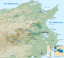
235:, such as the Wadi Chrita, the Wadi Mansoura and the Wadi Oum El Mellah, it retains water all year round only occasionally. The catchment area is 360 square kilometres (140 sq mi) and the system empties into the
55:
102:
365:
265:
231:
and consists of three depressions: the Sidi El Hani sebkha stricto sensu, the Sebkha
Souassi and the Sekha Dkhila. Fueled by several
399:
389:
253:
358:
242:
394:
384:
351:
208:
84:
295:
236:
156:
39:
335:
378:
134:
323:
17:
117:
104:
216:
204:
139:
224:
331:
228:
212:
88:
220:
290:
241:
232:
223:
and 25 kilometres (16 mi) southeast of the city of
339:
179:
171:
163:
154:
149:
133:
94:
80:
32:
95:
62:
359:
8:
198:
366:
352:
29:
199:
27:Salt lake in Sousse Governorate, Tunisia
282:
249:
146:
178:
170:
162:
153:
7:
320:
318:
338:. You can help Knowledge (XXG) by
25:
322:
264:
252:
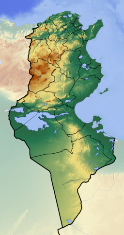
61:
54:
38:
246:Map of Sebkhet de Sidi El Hani
227:. It covers an area of 36,000
1:
271:Sebkhet Sidi Alhani Structure
215:, 25 kilometres (16 mi)
79:
259:Sebkhet Sidi Alhani Salt pan
44:Sebkhet Sidi Alhani Colours.
416:
317:
298:Sites Information Service
187:
49:
37:
400:Tunisia geography stubs
390:Ramsar sites in Tunisia
69:Sebkhet de Sidi El Hani
33:Sebkhet de Sidi El Hani
334:location article is a
247:
291:"Sebkhet Sidi Elhani"
245:
195:Sebkha Sidi El Hani
167:Sebkhet Sidi Elhani
114: /
18:Sebkhet Sidi Elhani
395:Sousse Governorate
248:
209:Sousse Governorate
180:Reference no.
85:Sousse Governorate
347:
346:
237:Mediterranean Sea
191:
190:
145:
144:
16:(Redirected from
407:
385:Lakes of Tunisia
368:
361:
354:
326:
319:
309:
308:
306:
304:
287:
268:
256:
202:
201:
200:سبخة سيدي الهاني
147:
129:
128:
126:
125:
124:
119:
115:
112:
111:
110:
107:
97:
65:
64:
58:
42:
30:
21:
415:
414:
410:
409:
408:
406:
405:
404:
375:
374:
373:
372:
315:
313:
312:
302:
300:
289:
288:
284:
279:
272:
269:
260:
257:
219:of the city of
175:2 February 2012
159:
122:
120:
118:35.55°N 10.41°E
116:
113:
108:
105:
103:
101:
100:
76:
75:
74:
73:
72:
71:
70:
66:
45:
28:
23:
22:
15:
12:
11:
5:
413:
411:
403:
402:
397:
392:
387:
377:
376:
371:
370:
363:
356:
348:
345:
344:
327:
311:
310:
281:
280:
278:
275:
274:
273:
270:
263:
261:
258:
251:
189:
188:
185:
184:
181:
177:
176:
173:
169:
168:
165:
161:
160:
157:Ramsar Wetland
155:
152:
151:
143:
142:
137:
131:
130:
98:
92:
91:
82:
78:
77:
68:
67:
60:
59:
53:
52:
51:
50:
47:
46:
43:
35:
34:
26:
24:
14:
13:
10:
9:
6:
4:
3:
2:
412:
401:
398:
396:
393:
391:
388:
386:
383:
382:
380:
369:
364:
362:
357:
355:
350:
349:
343:
341:
337:
333:
328:
325:
321:
316:
299:
297:
292:
286:
283:
276:
267:
262:
255:
250:
244:
240:
238:
234:
230:
226:
222:
218:
214:
210:
206:
196:
186:
182:
174:
166:
164:Official name
158:
148:
141:
138:
136:
132:
127:
99:
93:
90:
86:
83:
57:
48:
41:
36:
31:
19:
340:expanding it
329:
314:
301:. Retrieved
294:
285:
194:
192:
150:Designations
123:35.55; 10.41
121: /
96:Coordinates
379:Categories
277:References
172:Designated
217:southwest
205:salt lake
140:salt lake
303:25 April
229:hectares
225:Kairouan
81:Location
332:Tunisia
213:Tunisia
207:in the
203:) is a
109:10°25′E
106:35°33′N
89:Tunisia
296:Ramsar
221:Sousse
330:This
233:wadis
336:stub
305:2018
193:The
183:2019
135:Type
211:of
381::
293:.
239:.
87:,
367:e
360:t
353:v
342:.
307:.
197:(
20:)
Text is available under the Creative Commons Attribution-ShareAlike License. Additional terms may apply.