50:
66:
137:
73:
260:- Oltinga Secondary School is built on the escarpment and overviews Selela village. This (boarding) school has grown quite rapidly in the last few years and now hosts around 800 students from the region around Selela. The name comes from the Maasai word for 'water basin', which is located near to the school. Head teacher is Mr. Kitali.
270:
books, storage cupboards et cetera), but also construction materials for classrooms, teachers houses, dormitories and water storage units. Also laptops and tablets have been provided for the schools. Furthermore the medical dispensaries received, for example, medical supplies, wheelchairs, walkers and a solar installation.
269:
Selela has a dispensary and since 2016 a dispensary at Mbaash has opened as well. Selela and Mbaash are supported by
Tanzania Support Foundation. This NGO, founded in The Netherlands, especially helped the Selela schools with several supplies (for example school desks, computers, books, exercise
256:- In the subvillage of Mbaash (which means 'between the mountains' in Maasai language), about 16 km from Selela, there's also primary school which counts more than 700 children. This is an official boarding school. The head teacher is Mr. Paakwai Meitamei.
387:
258:- A third primary school is about 7 km from Selela village and is called Ndinyika Primary School, with more than children. Ndinyika means 'far from the boma' in Maasai language. .
339:
372:
430:
383:
350:
310:
241:
97:
314:
49:
244:
report there were 14,275 people in the ward (55% female - 45% male; average household size: 4.3), from 9,712 in 2016 and 8,703 in 2012.
690:
423:
65:
340:
Administrative Units
Population Distribution Report - Tanzania Mainland - Population Distribution by Administrative Areas
630:
278:
Every
Wednesday there's a market day at Selela village. In the village there are some guesthouses and small shops.
685:
463:
416:
379:
346:
306:
503:
161:
149:
298:
498:
468:
173:
40:
488:
439:
301:[Population Estimates in Administrative Areas for the Year 2016, Mainland Tanzania]
218:
205:
166:
299:
2016 Makadirio ya Idadi ya Watu katika
Majimbo ya Uchaguzi kwa Mwaka 2016, Tanzania Bara
679:
554:
549:
513:
449:
222:
154:
373:
2012 Population and
Housing Census - Population Distribution by Administrative Areas
597:
559:
508:
523:
112:
99:
483:
196:
254:- Selela Primary School is the largest and counts almost 1,200 children. .
664:
575:
518:
493:
473:
226:
142:
478:
129:
533:
201:
408:
412:
217:
is the name of a village and an administrative ward in the
651:
623:
606:
584:
568:
542:
456:
195:
187:
182:
172:
160:
148:
128:
26:
424:
293:
291:
8:
431:
417:
409:
23:
252:In Selela there are a number of schools:
287:
194:
181:
127:
92:
58:
46:
16:Ward in Monduli District, Arusha Region
242:Tanzania National Bureau of Statistics
320:from the original on 27 December 2021
186:
171:
159:
147:
7:
624:National Parks and Forest Reserves
393:from the original on 26 March 2022
14:
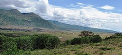
54:View at Selela in the Rift Valley
644:Monduli Mountains Forest Reserve
135:
71:
64:
48:
21:Ward in Arusha Region, Tanzania
72:
1:
384:National Bureau of Statistics
351:National Bureau of Statistics
311:National Bureau of Statistics
707:
631:Lake Manyara National Park
446:
93:
59:
47:
38:
658:Lolkisale Forest Reserve
638:Lolkisale Forest Reserve
237:in the Maasai language.
30:
635:Tarangire National Park
569:National Historic Sites
380:Dar es Salaam, Tanzania
347:Dar es Salaam, Tanzania
307:Dar es Salaam, Tanzania
305:(Report) (in Swahili).
691:Wards of Arusha Region
607:Major Cities and Towns
641:Burko Forest Reserve
109: /
188: • Total
85:Location of Selela
673:
672:
652:Monduli Landmarks
499:Meserani, Monduli
469:Engutoto, Monduli
353:. 1 December 2022
212:
211:
33:
698:
686:Monduli District
594:Mto wa Mbu River
585:Rivers and Lakes
489:Majengo, Monduli
440:Monduli District
433:
426:
419:
410:
403:
402:
400:
398:
392:
386:. 1 March 2013.
377:
369:
363:
362:
360:
358:
344:
336:
330:
329:
327:
325:
319:
313:. 1 April 2016.
304:
295:
219:Monduli District
167:Monduli District
141:
139:
138:
124:
123:
121:
120:
119:
114:
113:3.205°S 35.944°E
110:
107:
106:
105:
102:
75:
74:
68:
52:
31:
24:
706:
705:
701:
700:
699:
697:
696:
695:
676:
675:
674:
669:
647:
619:
602:
580:
564:
538:
452:
442:
437:
407:
406:
396:
394:
390:
375:
371:
370:
366:
356:
354:
342:
338:
337:
333:
323:
321:
317:
302:
297:
296:
289:
284:
276:
267:
261:
259:
257:
255:
253:
250:
136:
134:
117:
115:
111:
108:
103:
100:
98:
96:
95:
89:
88:
87:
86:
83:
82:
81:
80:
76:
55:
43:
34:
29:
22:
17:
12:
11:
5:
704:
702:
694:
693:
688:
678:
677:
671:
670:
668:
667:
662:
659:
655:
653:
649:
648:
646:
645:
642:
639:
636:
633:
627:
625:
621:
620:
618:
617:
614:
610:
608:
604:
603:
601:
600:
595:
592:
588:
586:
582:
581:
579:
578:
572:
570:
566:
565:
563:
562:
557:
552:
546:
544:
543:Native Peoples
540:
539:
537:
536:
531:
526:
521:
516:
511:
506:
501:
496:
491:
486:
481:
476:
471:
466:
460:
458:
454:
453:
447:
444:
443:
438:
436:
435:
428:
421:
413:
405:
404:
364:
331:
286:
285:
283:
280:
275:
272:
266:
263:
249:
246:
210:
209:
199:
193:
192:
189:
185:
184:
180:
179:
176:
170:
169:
164:
158:
157:
152:
146:
145:
132:
126:
125:
118:-3.205; 35.944
91:
90:
84:
78:
77:
70:
69:
63:
62:
61:
60:
57:
56:
53:
45:
44:
39:
36:
35:
32:Kata ya Selela
27:
20:
15:
13:
10:
9:
6:
4:
3:
2:
703:
692:
689:
687:
684:
683:
681:
666:
663:
660:
657:
656:
654:
650:
643:
640:
637:
634:
632:
629:
628:
626:
622:
615:
612:
611:
609:
605:
599:
596:
593:
590:
589:
587:
583:
577:
574:
573:
571:
567:
561:
558:
556:
553:
551:
548:
547:
545:
541:
535:
532:
530:
527:
525:
522:
520:
517:
515:
514:Monduli Mjini
512:
510:
507:
505:
502:
500:
497:
495:
492:
490:
487:
485:
482:
480:
477:
475:
472:
470:
467:
465:
462:
461:
459:
455:
451:
445:
441:
434:
429:
427:
422:
420:
415:
414:
411:
389:
385:
381:
374:
368:
365:
352:
348:
341:
335:
332:
316:
312:
308:
300:
294:
292:
288:
281:
279:
273:
271:
264:
262:
247:
245:
243:
238:
236:
232:
228:
224:
223:Arusha Region
220:
216:
207:
203:
200:
198:
190:
177:
175:
168:
165:
163:
156:
155:Arusha Region
153:
151:
144:
133:
131:
122:
94:Coordinates:
67:
51:
42:
37:
25:
19:
598:Lake Manyara
528:
450:Monduli Town
395:. Retrieved
367:
355:. Retrieved
334:
322:. Retrieved
277:
268:
251:
240:In 2022 the
239:
234:
230:
214:
213:
18:
591:Simba River
509:Monduli Juu
357:29 February
235:Clean water
229:. The name
116: /
680:Categories
661:Losimingor
616:Mto wa Mbu
524:Mto wa Mbu
378:(Report).
345:(Report).
282:References
183:Population
104:35°56′38″E
484:Lolkisale
448:Capital:
248:Education
197:Time zone
101:3°12′18″S
665:Kerimasi
576:Engaruka
519:Mswakini
494:Makuyuni
474:Esilalei
464:Engaruka
388:Archived
315:Archived
227:Tanzania
162:District
143:Tanzania
613:Monduli
479:Lepurko
274:Economy
221:of the
130:Country
555:Maasai
550:Arusha
534:Sepeko
529:Selela
397:3 July
324:3 July
265:Health
233:means
231:Selela
215:Selela
191:14,275
178:Selela
150:Region
140:
79:Selela
28:Selela
560:Iraqw
504:Moita
457:Wards
391:(PDF)
376:(PDF)
343:(PDF)
318:(PDF)
303:(PDF)
202:UTC+3
399:2022
359:2024
326:2022
174:Ward
41:Ward
225:of
206:EAT
682::
382::
349::
309::
290:^
432:e
425:t
418:v
401:.
361:.
328:.
208:)
204:(
Text is available under the Creative Commons Attribution-ShareAlike License. Additional terms may apply.