40:
59:
800:
553:
91:
604:
Hoekstra, J. M.; Molnar, J. L.; Jennings, M.; Revenga, C.; Spalding, M. D.; Boucher, T. M.; Robertson, J. C.; Heibel, T. J.; Ellison, K. (2010). Molnar, J. L. (ed.).
281:
725:
700:
159:
560:
770:
139:
557:
114:
730:
119:
621:
795:
505:
745:
572:
490:
613:
307:
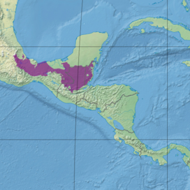
The Petén–Veracruz moist forests cover an area of 149,100 square kilometers (57,600 sq mi), extending from central
129:
740:
735:
513:
245:
525:
395:, where the lowland Petén–Veracruz forests yield to montane moist forests and pine–oak forests. In central Veracruz, the
785:
577:
780:
343:
of
Guatemala. The Petén–Veracruz moist forests mostly occupy a coastal lowland with meandering rivers, including the
790:
765:
549:
533:
134:
708:
760:
755:
775:
750:
501:
439:
521:
509:
419:
384:
344:
144:
124:
517:
486:
400:
380:
169:
545:
431:
408:
174:
154:
109:
537:
423:
396:
392:
368:
164:
497:
352:
74:
379:
The ecoregion is bounded on the south by a series of mountain ranges and highlands, including the
412:
149:
617:
458:(250-900 CE) was centered in the eastern and southern portions of the ecoregion, known as the
455:
79:
608:
The Atlas of Global
Conservation: Changes, Challenges, and Opportunities to Make a Difference
364:
348:
39:
388:
336:
658:
470:
356:
606:
541:
435:
404:
360:
340:
719:
427:
466:
687:
637:
58:
328:
292:
277:
230:
49:
403:
further north. The western portion of the ecoregion mostly extends to the
27:
Tropical moist broadleaf forest ecoregion in Belize, Guatemala, and Mexico
17:
529:
462:, from Tabasco and northern Chiapas across northern Guatemala to Belize.
324:
308:
474:
320:
316:
332:
312:
296:
288:
224:
219:
418:
The eastern portion of the ecoregion is bounded on the north by the
451:
284:
86:
45:
485:
22% of the ecoregion is in protected areas. These include the
801:
Neotropical tropical and subtropical moist broadleaf forests
450:
The northern Petén–Veracruz moist forests were home to the
454:
culture, which built cities between 1200 and 400 BCE. The
426:. The Petén–Veracruz moist forests extend east to the
469:
inhabit the eastern portion of the ecoregion, while
399:separate the Petén–Veracruz moist forests from the
262:
254:
244:
239:
212:
204:
199:
191:
183:
97:
85:
73:
68:
32:
605:
92:tropical and subtropical moist broadleaf forests
311:state across portions of the Mexican states of
282:tropical and subtropical moist broadleaf forest
707:. National Geographic Society. Archived from
8:
411:and the flooded forests and wetlands of the
422:, which extend east and west across the
208:149,100 km (57,600 sq mi)
599:
597:
595:
593:
589:
160:Sierra Madre de Oaxaca pine–oak forests
115:Central American Atlantic moist forests
107:
653:
651:
407:, although the montane forests of the
29:
477:peoples inhabit the western portion.
140:Mesoamerican Gulf–Caribbean mangroves
7:
430:in Belize, surrounding enclaves of
25:
699:World Wildlife Fund, ed. (2001).
120:Central American pine–oak forests
561:flora and fauna protection areas
415:constitute distinct ecoregions.
57:
38:
573:List of ecoregions in Guatemala
491:Montes Azules Biosphere Reserve
442:run along the Caribbean coast.
63:Ecoregion territory (in purple)
771:Flora of the Yucatán Peninsula
701:"Petén-Veracruz moist forests"
688:"Petén-Veracruz moist forests"
659:"Petén-Veracruz moist forests"
638:"Petén-Veracruz moist forests"
614:University of California Press
496:Other protected areas include
130:Chiapas Depression dry forests
1:
731:Ecoregions of Central America
726:Petén–Veracruz moist forests
578:List of ecoregions in Mexico
274:Petén–Veracruz moist forests
44:Forest surrounding ruins of
33:Petén–Veracruz moist forests
705:WildWorld Ecoregion Profile
817:
135:Chimalapas montane forests
456:Classic Maya civilisation
56:
37:
796:Geography of Mesoamerica
440:Belizean Coast mangroves
438:and near the coast. The
746:Ecoregions of Guatemala
385:Sierra Madre de Chiapas
145:Oaxacan montane forests
125:Chiapas montane forests
694:. World Wildlife Fund.
692:Terrestrial Ecoregions
644:. World Wildlife Fund.
642:Terrestrial Ecoregions
489:in Guatemala, and the
487:Maya Biosphere Reserve
401:Veracruz moist forests
381:Sierra Madre de Oaxaca
327:, as well as northern
170:Veracruz moist forests
546:Bladen Nature Reserve
432:Belizian pine forests
420:Yucatán moist forests
409:Sierra de los Tuxtlas
175:Yucatan moist forests
155:Sierra de los Tuxtlas
110:Belizian pine forests
741:Ecoregions of Belize
736:Ecoregions of Mexico
554:Cascada de Agua Azul
550:Cañón del Usumacinta
544:biosphere reserves,
526:Cañón del Río Blanco
397:Veracruz dry forests
393:Guatemalan Highlands
165:Veracruz dry forests
518:Sierra del Lacandón
375:Adjacent ecoregions
339:of Chiapas and the
250:critical/endangered
246:Conservation status
781:Flora of Guatemala
522:Cañón del Sumidero
413:Pantanos de Centla
335:. It includes the
150:Pantanos de Centla
791:Forests of Mexico
766:Flora of Campeche
623:978-0-520-26256-0
424:Yucatán Peninsula
270:
269:
16:(Redirected from
808:
786:Petén Department
761:Flora of Chiapas
756:Flora of Tabasco
712:
695:
674:
673:
671:
669:
655:
646:
645:
634:
628:
627:
611:
601:
532:national parks,
61:
42:
30:
21:
816:
815:
811:
810:
809:
807:
806:
805:
776:Flora of Belize
751:Flora of Oaxaca
716:
715:
698:
686:
683:
678:
677:
667:
665:
657:
656:
649:
636:
635:
631:
624:
603:
602:
591:
586:
569:
514:Sarstoon-Temash
483:
448:
389:Chiapas Plateau
337:Lacandon Forest
305:
235:
179:
106:
105:
64:
52:
28:
23:
22:
15:
12:
11:
5:
814:
812:
804:
803:
798:
793:
788:
783:
778:
773:
768:
763:
758:
753:
748:
743:
738:
733:
728:
718:
717:
714:
713:
711:on 2010-03-08.
696:
682:
681:External links
679:
676:
675:
647:
629:
622:
588:
587:
585:
582:
581:
580:
575:
568:
565:
542:Selva El Ocote
482:
479:
465:Today, modern
447:
444:
436:Maya Mountains
405:Gulf of Mexico
377:
376:
304:
301:
268:
267:
264:
260:
259:
256:
252:
251:
248:
242:
241:
237:
236:
234:
233:
228:
222:
216:
214:
210:
209:
206:
202:
201:
197:
196:
193:
192:Mammal species
189:
188:
185:
181:
180:
178:
177:
172:
167:
162:
157:
152:
147:
142:
137:
132:
127:
122:
117:
112:
103:
102:
101:
99:
95:
94:
89:
83:
82:
77:
71:
70:
66:
65:
62:
54:
53:
43:
35:
34:
26:
24:
14:
13:
10:
9:
6:
4:
3:
2:
813:
802:
799:
797:
794:
792:
789:
787:
784:
782:
779:
777:
774:
772:
769:
767:
764:
762:
759:
757:
754:
752:
749:
747:
744:
742:
739:
737:
734:
732:
729:
727:
724:
723:
721:
710:
706:
702:
697:
693:
689:
685:
684:
680:
664:
663:DOPA Explorer
660:
654:
652:
648:
643:
639:
633:
630:
625:
619:
615:
610:
609:
600:
598:
596:
594:
590:
583:
579:
576:
574:
571:
570:
566:
564:
562:
559:
555:
551:
547:
543:
539:
538:Nahá–Metzabok
535:
531:
527:
523:
519:
515:
511:
507:
503:
499:
494:
492:
488:
480:
478:
476:
472:
468:
463:
461:
457:
453:
445:
443:
441:
437:
433:
429:
428:Caribbean Sea
425:
421:
416:
414:
410:
406:
402:
398:
394:
390:
386:
382:
374:
373:
372:
370:
366:
362:
358:
354:
353:Coatzacoalcos
350:
346:
342:
338:
334:
330:
326:
322:
318:
314:
310:
302:
300:
298:
294:
290:
286:
283:
279:
275:
265:
261:
257:
253:
249:
247:
243:
238:
232:
229:
226:
223:
221:
218:
217:
215:
211:
207:
203:
198:
194:
190:
186:
182:
176:
173:
171:
168:
166:
163:
161:
158:
156:
153:
151:
148:
146:
143:
141:
138:
136:
133:
131:
128:
126:
123:
121:
118:
116:
113:
111:
108:
100:
96:
93:
90:
88:
84:
81:
78:
76:
72:
67:
60:
55:
51:
47:
41:
36:
31:
19:
709:the original
704:
691:
668:27 September
666:. Retrieved
662:
641:
632:
607:
495:
484:
481:Conservation
467:Mayan people
464:
459:
449:
417:
378:
331:and most of
306:
273:
271:
255:Habitat loss
240:Conservation
184:Bird species
493:in Mexico.
341:Petén Basin
80:Neotropical
720:Categories
584:References
510:Monkey Bay
506:Guanacaste
502:El Rosario
471:Mixe–Zoque
460:Selva Maya
365:Usumacinta
349:Papaloapan
18:Selva Maya
329:Guatemala
293:Guatemala
287:found in
278:ecoregion
263:Protected
231:Guatemala
213:Countries
200:Geography
50:Guatemala
567:See also
558:Chan-Kin
534:Calakmul
530:Palenque
361:Grijalva
325:Campeche
309:Veracruz
475:Nahuatl
434:in the
321:Chiapas
317:Tabasco
303:Setting
280:of the
258:23.595%
98:Borders
69:Ecology
620:
556:, and
548:, and
540:, and
528:, and
446:People
391:, and
367:, and
357:Tonalá
345:Blanco
333:Belize
323:, and
313:Oaxaca
297:Mexico
295:, and
289:Belize
276:is an
266:24.25%
225:Belize
220:Mexico
498:Tikal
452:Olmec
369:Hondo
285:biome
87:Biome
75:Realm
46:Tikal
670:2021
618:ISBN
473:and
272:The
205:Area
104:List
195:191
187:468
722::
703:.
690:.
661:.
650:^
640:.
616:.
612:.
592:^
563:.
552:,
536:,
524:,
520:,
516:,
512:,
508:,
504:,
500:,
387:,
383:,
371:.
363:,
359:,
355:,
351:,
347:,
319:,
315:,
299:.
291:,
48:,
672:.
626:.
227:,
20:)
Text is available under the Creative Commons Attribution-ShareAlike License. Additional terms may apply.