59:
1236:
1115:
1064:
1809:
1433:
1973:
682:
1720:
1276:
1354:" is shown on the shores of the river, and the range of the Emperor of Mali's sway is suggested by all the black banners (an inscription notes "This lord of the blacks is called Musa Melli, Lord of Guinea, the greatest noble lord of these parts for the abundance of the gold which is collected in his lands". Curiously, there is a defiant gold-bannered town south of the river, labelled "
74:
1098:, Trans-Saharan traders gave the Senegal its famous nickname as the "River of Gold". The Trans-Saharan stories about the "River of Gold" reached the ears of Sub-Alpine European merchants that frequented the ports of Morocco and the lure proved irresistible. Arab historians report at least three separate Arab maritime expeditions - the last one organized by a group of eight
1623:
1271:"This river is called Wad al-Nil and also is called the River of Gold, for one can here obtain the gold of Palolus. And know that the greater part of those that live here occupy themselves collecting gold on the shores of the river which, at its mouth, is a league wide, and deep enough for the largest ship of the world."
3054:
Geografia di M. Livio Sanvto distinta in XII libri. Ne' quali, oltra l'esplicatione di molti luoghi di
Tolomeo e della Bussola, e dell' Aguglia; si dichiarano le Provincie, Popoli, Regni, Città; Porti, Monti, Fiumi, Laghi, e Costumi dell' Africa. Con XII tavole di essa Africa in dissegno di rame.
2405:
Cadamosto suggest this was begun in 1450: "Five years before I went on this voyage, this river was discovered by three caravels belonging to Don Henry, which entered it, and their commanders settled peace and trade with the Moors; since which time ships have been sent to this place every year to
2365:
The inscription above Kano reads merely: "Africa es apelada la terca part del mon, per rao dun rey afer fill d'abrae, qui la senyorega, laquai partida comensa en les pars degipte al flum del cales, e finey en gutzolanes les pars hoccidentals e combren tota la barberia environant tôt lo mis jorn"
1715:
to explore upriver for settlements, thus becoming the first
European to actually enter the Senegal river. He didn't get very far. Venturing ashore at one point along the river bank, Afonso tried to kidnap two Wolof children from a woodsman's hut. But he ran into their father, who proceeded to
2347:"Aquest flum es apelat ued anil axi matex es apelat riu de lor per tal com si requyl lor de palola. Et scire debeatis quod major pars gentium in partibus istis habitantium sunt electi ad colligendum aurum ipso flumine, qui habet latitudinem unius legue et fondum pro majori nave mundi"
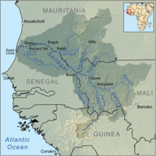
752:, which also has its source in Guinea, subsequently runs along a small part of the Guinea-Mali frontier to then trace most of the Senegal-Mali border up to Bakel. The Senegal further flows through semi-arid land in the north of Senegal, forming the border with Mauritania and into the
1043:
were connected to each other, and formed a single river flowing from east to west, which they called the "Western Nile". (In fact, some of the headwaters of the
Senegal River are near the Niger River in Mali and Guinea.) It was believed to be either a western branch of the Egyptian
1996:"). Bailot speculates the name probably arose as a misunderstanding, that when a Portuguese captain came across some Wolof fishermen and asked them what the name of the river was, they believed he was asking who their fishing boat belonged to, and replied simply "it is our canoe" (
1607:), where he heard that most people along its shores were engaged in the collection of gold and that the river was wide and deep enough for the largest ships. Nothing more is heard of him either. In 1402, after establishing the first European colony on the
606:
joined in 2005. As of 2012, only very limited use was made of the river for the transportation of goods and passengers. The OMVS have looked at the feasibility of creating a navigable channel 55 m (180 ft) in width between the small town of
2877:
Primo volume delle navigationi et viaggi nel qua si contine la descrittione dell'Africa, et del paese del Prete Ianni, on varii viaggi, dal mar Rosso a
Calicut,& infin all'isole Molucche, dove nascono le Spetierie et la navigatione attorno il
2803:
Primo volume delle navigationi et viaggi nel qua si contine la descrittione dell'Africa, et del paese del Prete Ianni, on varii viaggi, dal mar Rosso a
Calicut,& infin all'isole Molucche, dove nascono le Spetierie et la navigatione attorno il
1929:', and Cadamosto gives the personal name of the Senegal river chieftain as "Zucholin"). The confusion may have arisen because Cadamosto says the Portuguese interacted frequently with a certain Wolof chieftain south of the river, somewhere on the
1920:
asserts the
Portuguese renamed it "Senegal" because that was the personal name of a local Wolof chieftain who frequently conducted business with the Portuguese traders. But this etymology is doubtful (e.g. the ruler of Senegalese river state of
1815:
region, detail from the map of
Guillaume Delisle (1707), which still assumes the Senegal connected to the Niger; this would be corrected in subsequent edititions of Delisle's map (1722, 1727), where it was shown ending at a lake, south of the
907:
At the present time, only very limited use is made of the river for the transport of goods and passengers. The OMVS have looked at the feasibility of creating a navigable channel 55 m (180 ft) in width between the small town of
1201:. The legend of Cape Bojador as a terrifying obstacle, the 'cape of no return' to European sailors, emerged around the same time (possibly encouraged by Trans-Saharan traders who did not want to see their land route sidestepped by sea).
1554:
parallel rivers running east to west, both of them sourced from the same great internal lake (which, Fra Mauro asserts, is also the same source as the
Egyptian Nile). Mauro names the two parallel rivers differently,calling one
2478:
By confounding the
Ptolemy's Greek 'Nigir' with the Latin word for "black", Leo Africanus assumed the "Nile of the Blacks" (i.e. Senegal-Niger of the Arab traders) must be the Nigir of the ancients. See Leo Africanus, (Ital:
2907:
Primera Parte de la
Descripción General de Áffrica, con todos los successos de guerras que a auido entre los infieles, ye el pueblo Christiano, y entre ellos mesmos, desde que Mahoma inueto su secta, hasta el año del señor
2797:(1460s) "Il Libro di Messer Alvise Ca da Mosto Gentilhuomo Venetiano" & "Navigatione del Capitano Pietro di Sintra Portoghese scritta per il medesimo M. Alvise da Ca da Mosto", as printed in Venice (1550), by
2124:
SENEGAL-HYCOS: Renforcement des capacités nationales et régionales d'observation, transmission et traitement de données pour contribuer au développement durable du bassin du Fleuve Sénégal (Document de projet
2810:(English translation: "Original Journals of the Voyages of Cada Mosto and Piedro de Cintra to the Coast of Africa, the former in the years 1455 and 1456, and the latter soon afterwards", in R. Kerr, 1811,
1688:(sometimes given as Dinis Fernandes) was the first known European since antiquity to finally reach the mouth of the Senegal River. However, Dias did not sail upriver, but instead kept sailing down the
1290:
is depicted off the coast on the left, with a quick note about his 1346 voyage. The golden round island at the mouth of the Senegal River is the indication (customary on portolan charts) of river
2983:
Monteil, Vincent (1968). "al-Bakri (Cordoue, 1068) - Routier de l'Afrique blanche et noire du Nord-Ouest: Traduction nouvelle de seize chapitres, sur le MS arabe 17 Bd PSS/902 du British Museum".
1680:. Bad weather or lack of supplies prevented Tristão from actually reaching the mouth of the Senegal River, but he rushed back to Portugal to report he had finally found the "Land of the Blacks" (
3187:
2334:
Delafosse (1912: v.1,p.55), Crone (1937: p.xv), Mauny (1961: p.302), Levtzion (1973: p.155). However, McIntosh (1981) suggests an alternative identification of this riverine "island" to be the
897:
599:
1957:
already used by the Genoese back in the 14th century as an alternative name of the Senegal River. It is almost certain that the Genoese "Vedamel" are corruptions from the Arabic, either
2018:
A strong challenge to this theory is that "Senegal" is much older, and might derive from "Sanghana" (also given as Isenghan, Asengan, Singhanah), a city described by the Arab historian
1654:
and emerged into an inlet, which they excitedly believed to be the mouth of the Senegal River. The name they mistakenly bestowed upon the inlet - "Rio do Ouro" - is a name it would
928:
635:
2356:"Aquest senyor dels negres es appelat musa melli, senyor de guineua, e aquest es el puys noble senyor de tota esta partida per labondansia del or lo qualse recull en la sua terra"
2366:(trans: "Africa is called the third part of the world, after King Afer, son of Abraham, who lorded over it, its beginning starts in the part of Egypt by the river of Cairo (
1365:
East of Mali, the river forms a lake or "Island of Gold" shown here studded with river-washed gold nuggets (this is what the Pizzigani brothers called the island of "
1251:
gives perhaps the most detailed depiction of the early state of European knowledge about the Senegal River prior to the 1440s. Viladestes labels it "River of Gold" ("
1716:
chase the Portuguese back to their launch and gave them such a beating that the explorers gave up on going any further, and turned back to the waiting caravels.
476:
2895:
The Discoveries of Prince Henry the Navigator: and their results; being the narrative of the discovery by sea, within one century, of more than half the world
1575:" ("Land of Palms"). It is notable that Fra Mauro knew of the error of Henry the Navigator's captains about the Daklha inlet, which Mauro carefully labels "
2751:
2230:. There is a report from an Arab commander from the 750s who claims to have reached as far south as "the Nile" (i.e. the Senegal). See Hrbek (1992: p.308).
2201:). In French, see Monteil (1968). For an attempt to reconstruct the Senegal river's course from the accounts of al-Bakri and al-Idrisi, see Cooley (1841:
2410:) The identification of Lourenço Dias as the opener of Portuguese trade on the Senegal River is suggested in a 1489 document. See Russell (2000:p.97n14).
1039:
of Sicily (1154), provided some of the earliest descriptions of the Senegal River. Early Arab geographers believed the upper Senegal River and the upper
1369:", and most commentators take to indicate the Bambuk-Buré goldfields). It is connected by many streams to the southerly "mountains of gold" (labelled "
1761:
on most subsequent Portuguese maps of the age. Cadamosto relates the legend that both the Senegal and the Egyptian Nile were branches of the Biblical
58:
563: sq mi), a mean flow of 680 m/s (24,000 cu ft/s), and an annual discharge of 21.5 km (5.2 cu mi). Important
3254:
3259:
2675:
Monod & Mauny, in the French translation of Zurara, although it is already noted by editor Kerr in the 1811 English translation of Cadamosto.
1642:, finally surpassed Cape Bojador and returned to tell about it. Henry immediately dispatched a follow-up mission in 1435, under Gil Eanes and
3143:
1550:, drawn a half-century later, after the Portuguese had already visited the Senegal (albeit still trying to respect Classical sources), shows
2122:
1204:
The river is frequently depicted with a great river island midway, the "Island of Gold", first mentioned by al-Masudi, and famously called "
1235:
1743:(a little below that), drumming up a profitable business exchanging Mediterranean goods (notably, horses) for gold and slaves. Chronicler
1587:
Christian Europeans soon began attempting to find the sea route to the mouth of the Senegal. The first known effort may have been by the
3269:
2914:
Mauny, R. (1961). "Tableau géographique de l'ouest africain au moyen-âge d' après les sources écrites, la tradition et l'archéologie".
1267:" (possibly Cape Timris). There are extensive notes about the plentifulness of ivory and gold in the area, including a note that reads
587:, runs parallel to the main river to the north. After 200 km (120 mi) the two branches rejoin a few kilometers downstream of
2973:
2630:
The "River of Treasure" interpretation of Vedamel can be found in J.G.H. "'Histoire du commerce entre le Levant et l'Europe' in 1831,
2533:
885:
runs parallel to the main river to the north. After 200 km (120 mi) the two branches rejoin a few kilometres downstream of
3162:
3040:
2214:
The term "Nile" seems to have been applied quite early to the Senegal. During the Arab conquest of North Africa in the 8th century,
1015:
In the Early Middle Ages (c. 800 CE), the Senegal River restored contact with the Mediterranean world with the establishment of the
2484:
2257:
2030:(Laurentian Gaddiano portolan). This town ("Isingan") is fantastically depicted in the 1413 portolan map of Majorcan cartographer
2767:
1178:
1126:
Drawing from Classical legend and Arab sources, the "River of Gold" found its way into European maps in the 14th century. In the
2093:
2042:) or 'sagui nughal' ('border'). Some sources claim 'Isinghan' remained the usual Berber term to refer to the Wolof kingdom of
2022:
in 1068 as located by the mouth of the Senegal River (straddling both banks) and the capital of a local kingdom. The location
1500:
1049:
2374:("gutzolanes"; Cape Non was called "Caput finis Gozolae" after the Gazzula Berbers of the western Sahara) and covers all of
1527:
in the garb of a Christian bishop (coincidentally, this is the first visual depiction of Prester John on a portolan chart).
534:
376:
2692:, p.55) believes that al-Idrisi, contrarily to al-Bakri, might have confused Sanghana with Ganah/Awkat, the capital of the
1471:, etc.) towards the Mediterranean coast. There is an unlabeled depiction of a black African man on a camel traveling from "
3249:
1495:- long defunct, but, on the other hand, contemporaneous with the depicted Abu Bakr). Nearby sits its Arab-looking king ("
1197:, etc. the "River of Gold" is depicted (if only speculatively), draining into the Atlantic Ocean somewhere just south of
947:
The existence of the Senegal River was known to the early Mediterranean civilizations. It or some other river was called
2828:
The Negroland of the Arabs examined and explained; or, An inquiry into the early history and geography of Central Africa
815:
662:
1216:-Buré goldfield district, which is practically surrounded on all sides by rivers - the Senegal river to the north, the
3200:
2764:
Décadas da Ásia: Dos feitos, que os Portuguezes fizeram no descubrimento, e conquista, dos mares, e terras do Oriente.
1592:
1306:" (arguably the etymological source of the term "Senegal"). East of that, the Senegal forms a riverine island called "
1154:
shows both the Egyptian Nile and the western Nile stemming from the same internal mountain range, with the note that "
1643:
741:
1661:
Realizing the mistake, Henry kept pressing his captains further down the coast, and in 1445, the Portuguese captain
3244:
823:
666:
2617:'s 1346 trip to the River Gold, "Istud flumen vocatur Vedamel similiter vocatur riu Auri". See G. Gråberg (1802)
1106:(before 1147) - that tried to sail down the Atlantic coast, possibly in an effort find the mouth of the Senegal.
298:
220:
2872:
2822:
2798:
2787:
Esquisses sénégalaises: physionomie du pays, peuplades, commerce, religions, passé et avenir, récits et légendes'
2424:
1684:), and that the "Nile" was surely nearby. Shortly after (possibly still within that same year) another captain,
3010:
2545:
2495:
1841:
1786:
1134:
to the coast of Africa, albeit without communication with Atlantic (it ends in a lake). It depicts some giant
916:, a distance of 905 km (562 mi). It would give landlocked Mali a direct route to the Atlantic Ocean.
811:
143:
2306:
3264:
2902:
2053:
from the south have advanced the claim that the river's name is originally derived from the compound of the
1704:
1417:?) are denoted along the same single river. South of them (barely visible) are what seem like the towns of
1151:
1150:, there is an unnamed river stemming from the African interior and opening in the Atlantic ocean. The 1351
1147:
1000:
788:
is located, to then turn south. It is separated from the Atlantic Ocean by a thin strip of sand called the
709:
3239:
2499:
1647:
1612:
1212:" in the 1367 Pizzigani brothers chart. It is conjectured that this riverine "island" is in fact just the
1114:
507:
3101:
3030:
1805:, published in 1588, sketches the Senegal, the Niger and the Gambia as three separate, parallel rivers.
1744:
1163:
1063:
2807:
2427:, publisher of the 1550 Italian edition of Cadamosto's memoir, refers to the gold from the Senegal as
1888:
and further along (again, Marmol assuming Senegal was connected to the Niger), the people of Bagamo' (
1808:
1595:, who set out down the coast in 1291 in a pair of ships (nothing more is heard of them). In 1346, the
1926:
1833:
1299:
1127:
1076:
913:
785:
686:
616:
361:
3106:
Crónica dos feitos notáveis que se passaram na Conquista da Guiné por mandado do Infante D. Henrique
2869:(1526) "Descrittione dell' Africa, & delle cose notabili che lui sono, per Giovan Lioni Africano
1708:
1728:
1635:
1631:
1616:
1448:
1432:
1240:
1194:
1016:
984:
976:
956:
3049:
2781:
2648:
2588:
2553:
2453:
2432:
1981:
1802:
1773:. He also notes that the Senegal was called "the Niger" by the ancients - probably a reference to
3090:
3014:
2952:
2773:
Beazley, C.R. (1899) "Introduction" to vol. 2 of C.R. Beazley and E. Prestage, editors, Zurara's
2635:
2132:
1832:(which according to one source, comes from "vi-dekh", Wolof for "this river"). His contemporary,
1798:
1669:, where he noticed the desert end and the treeline begin, and the population change from 'tawny'
1666:
1619:
set about immediately probing the African coast, looking for directions to the mouth of Senegal.
1414:
1295:
1119:
789:
1217:
863:
749:
733:
568:
2927:
McIntosh, Susan Keech (April 1981). "A Reconsideration of the Wangara/Palolus Island of Gold".
2745:
2131:(in French), Système Mondial d’Observation du Cycle Hydrologique (WHYCOS), 2007, archived from
2031:
1567:" ("In the sands of both these rivers gold of 'palola' may be found"), and nearer to the sea, "
1248:
619:, a distance of 905 km (562 mi). It would give landlocked Mali a direct route to the
3158:
3139:
3082:
3036:
2969:
2944:
2815:
2785:
2759:
2710:
2655:
2592:
2516:
2466:
2449:
2420:
2407:
2293:
2272:
2240:
2181:
1972:
1917:
1869:
1845:
1821:
1588:
1499:") holding a scimitar. The River of Gold is sourced at a circular island, what seem like the
1440:
1378:
1327:
858: cu ft/s), and an annual discharge of 21.5 km (5.2 cu mi). Important
807:
downstream on the Mauritania-Senegal border, near the outlet to the sea, preventing access of
3022:
2689:
2685:
2557:
2314:
2202:
2198:
1530:
Uniquely, the Viladestes map shows another river, south of the Senegal, which it labels the "
721:
3121:
3117:
3074:
2936:
2893:
2885:
2849:
2826:
2794:
2549:
2480:
1881:
1748:
1524:
972:
932:
3136:
The Mapping of Africa: a cartobibliography of printed maps of the African continent to 1700
681:
3002:
2439:! In all likelihood, "Tiber Gold" was just a generic Italian reference to river-dug gold.
2035:
1143:
952:
518:
498:
469:
45:
37:
2149:
1662:
1048:
or drawn from the same source (variously conjectured to some great internal lakes of the
697:
1980:
Other etymological theories for "Senegal" abound. A popular one, first proposed by Fr.
1579:" ("Rio do Ouro", Western Sahara), distinctly from the "Canal del Oro" (Senegal River).
2227:
2062:
2054:
1985:
1946:
1930:
1889:
1877:
1825:
1766:
1689:
1651:
1608:
1382:
1229:
1221:
1174:
1159:
992:
988:
867:
834:
804:
753:
745:
737:
658:
620:
572:
546:
490:
349:
29:
1719:
480:
Average monthly flow (m/s) at the Dagana hydrometric station over the period 1903-1974
3233:
2956:
2866:
2740:
2253:
2223:
2012:
1853:
1778:
1712:
1670:
1655:
1543:
1335:
1182:
1080:
996:
882:
800:
777:
717:
650:
584:
2193:
A translation of al-Bakri's 1068 account is found in Levtzion & Hopkins, (2000,
2163:
919:
The aquatic fauna in the Senegal River basin is closely associated with that of the
626:
The aquatic fauna in the Senegal River basin is closely associated with that of the
2693:
2614:
2050:
2039:
2027:
1861:
1840:(from "sunu dekh", Wolof for "our river"). Writing in 1573, the Spanish geographer
1790:
1732:
1677:
1600:
1539:
1516:
1492:
1484:
1374:
1287:
1256:
1198:
1091:
1084:
1024:
964:
920:
871:
827:
769:
761:
725:
701:
670:
627:
576:
196:
2882:
The History and Description of Africa, and of the notable things therein contained
2038:
origin, speculatively related to 'Ismegh' ('black slave', analogous to the Arabic
2004:
for its charm and appeal to national solidarity ("we're all in one canoe", etc.).
1777:'s legendary 'Nigir' (Νιγειρ) (below the Gir), which would be later identified by
1385:
of Sierra Leone). It is evident the Senegal river morphs east, unbroken, into the
713:
283:
2436:
1794:
1782:
1603:
set out on a galley with the explicit objective of finding the "River of Gold" (
1426:
1386:
1339:
1275:
1225:
1095:
1040:
1004:
909:
608:
530:
344:
119:
3191:
3078:
2940:
2435:), thus leading some to imagine it was also customary to call the Senegal the
2007:
More recent historians suggest the name "Senegal" is probably a derivation of
1812:
1685:
1504:
1358:" (probably the Ta'adjast of al-Idrisi), and might be an ichoate reference to
1347:
1045:
784:
and, approaching its mouth, around the Senegalese island on which the city of
542:
96:
73:
64:
3215:
3202:
3086:
2948:
1239:
Course of the "River of Gold" (Senegal-Niger) in the 1413 portolan chart of
391:
378:
313:
300:
235:
222:
158:
145:
2074:
1639:
1547:
1323:
1291:
1036:
1028:
924:
859:
693:
631:
564:
2335:
1425:(called "Zogde" in the Catalan Atlas) and much further southeast, probably
1359:
2371:
2215:
2019:
1901:
1770:
1596:
1456:
1421:(on the eastern shore of the Island of Gold), and east of that, probably
1394:
1190:
1186:
1068:
1032:
980:
960:
936:
878:
808:
765:
716:
in Mali. From there, the Senegal river flows west and then north through
639:
580:
2755:. Vol. 24 (11th ed.). Cambridge University Press. p. 639.
1622:
3094:
3062:
2812:
A General History of Voyages and Travels to the end of the 18th century
2375:
2001:
1993:
1774:
1673:
1638:, who invested heavily to reach it. In 1434, one of Henry's captains,
1488:
1468:
1053:
1020:
822:. The power station was replaced in 2014. In 2013, construction of the
685:
Fishermen on the bank of the Senegal River estuary at the outskirts of
538:
92:
2744:
1751:, writing in the 1460s, was already calling it the "Senega" [
1334:") on a camel. Further east, along the river, is the seated emperor (
1893:
1515:", his range depicted by crescent-on-gold banners) and the Christian
1503:(albeit unlabeled here). From this same source also flows north the
1476:
1447:
North of the Senegal-Niger are the various oases and stations of the
1422:
1418:
1410:
1319:
1311:
1213:
1103:
901:
890:
886:
705:
603:
1630:
The project of finding the Senegal was taken up in the 1420s by the
1507:
towards Egypt, which forms the frontier between the Muslim "king of
1142:" ("Here great ants guard gold sands"). In the mappa mundi made by
2898:(1877 ed.). London: S. Low, Marston, Searle, & Rivington.
2043:
1971:
1942:
1938:
1922:
1807:
1789:
in 1573, with the additional note that both the Senegal River and
1762:
1740:
1736:
1718:
1700:
1693:
1621:
1508:
1436:
1280:
1274:
1234:
1113:
1090:
As the Senegal River reached into the heart of the gold-producing
1062:
1057:
781:
773:
757:
729:
680:
588:
526:
935:
is moderately high, only three species of frogs and one fish are
2219:
2058:
2000:). The "our canoe" theory has been popularly embraced in modern
889:. The long strip of land between the two branches is called the
881:
the river divides into two branches. The left branch called the
819:
654:
612:
595:
100:
665:, built in 1927, but replaced in 2014. The construction of the
661:
downstream on the Mauritania-Senegal border. In between is the
1753:
1402:
1135:
796:
646:
474:
63:
Boats on the Senegal River, on the border between Senegal and
2871:"Descrittione dell’Africa", as printed in Venice (1550), by
1937:. "Budomel" is almost certainly a reference to the ruler of
1731:
opened regular trade contact on the Senegal River, with the
1302:). The first town, by the mouth of the Senegal, is called "
1707:
arrived at the mouth of the Senegal. One of its captains,
1443:
region of the Senegal River Valley, Abbé David Boilat, 1853
1130:(c. 1300), there is a river labelled "Nilus Fluvius" drawn
3176:. 2 volumes. Cairo: Société Royale de Géographie d'Égypte.
1571:" ("Here gold is collected"), and finally, on the coast, "
2218:
commanders launched several expeditionary raids from the
1747:, writing in 1453, still called it the "Nile River", but
3055:
Aggiuntivi de piu tre Indici da M. Giovan Carlo Saraceni
2638:. R.H. Major (p.113) proposes the "Nile" interpretation.
2861:
Corpus of early Arabic sources for West African history
2406:
trade with the natives." Cadamosto (Engl. 1811 trans.,
1727:
Sometime between 1448 and 1455, the Portuguese captain
1294:
or islands - in this case, probably a reference to the
923:
basin, and the two are usually combined under a single
630:
basin, and the two are usually combined under a single
3155:
West Africa Before the Colonial Era: a history to 1850
2997:
Relation universelle de l'Afrique, ancienne et moderne
2723:
2721:
2719:
2150:
UNH/GRDC Composite Runoff Fields V 1.0 data for Dagana
3114:
The Chronicle of the Discovery and Conquest of Guinea
2775:
The Chronicle of the Discovery and Conquest of Guinea
2569:
Barros, p. 109. This is reiterated in Marmol, Ch.8.3.
1565:
Inne larena de questi do fiume se trova oro de paiola
898:
Organisation pour la mise en valeur du fleuve Sénégal
600:
Organisation pour la mise en valeur du fleuve Sénégal
579:. The river divides into two branches once it passes
1961:("River of Treasure", i.e. Gold) or, alternatively,
1168:
iste fluuis exit de nilo ubi multum aurum repperitur
1138:
digging up gold dust from its sands, with the note "
1075:
Arab geographers Abd al-Hassan Ali ibn Omar (1230),
512:
3112:. [Trans. 1896-99 by C.R. Beazley and E. Prestage,
2370:= adjective of Cairo) and the western part ends at
1965:("River of Mali") or even, by transcription error,
1255:") and locates it a considerable distance south of
445:
437:
425:
417:
407:
368:
355:
343:
329:
290:
277:
269:
251:
212:
202:
192:
174:
135:
125:
115:
106:
88:
83:
23:
2530:Descripção e roteiro da costa occidental de Africa
1824:(writing in 1552) says the river's original local
818:which was originally completed in 1927 and uses a
2916:Mémoire de l'Institut Fondamental d'Afrique Noire
2859:Levtzion, N. and J.F.P. Hopkins, editors, (2000)
896:In 1972 Mali, Mauritania and Senegal founded the
1953:("lord"). Curiously, Budomel is reminiscent of
1646:. Going down the coast, they turned around the
1563:" ("Channel of Gold"), and makes the note that "
1279:Slave trade along the Senegal River, kingdom of
1118:Western Nile (Senegal-Niger River) according to
1067:Western Nile (Senegal-Niger River) according to
851: sq mi), a mean flow of 680 m/s (
2844:Africa from the Seventh to the Eleventh century
2095:Hydrographic data for Dagana, Senegal 1903-1974
1269:
638:. Only three species of frogs and one fish are
3110:Chronica do descobrimento e conquista da Guiné
2688:). Monteil (1964: p. 91; 1968). Cooley (1841:
2632:Antologia; giornale di scienze, lettere e arti
2552:. See also Phérotée de La Croix (1688: Ch. 2
3063:"The Fra Mauro Portolan chart in the Vatican"
2311:Roteiro de Lisboa a Goa por D. João de Castro
2098:, Unesco International Hydrological Programme
2026:is depicted in 1351 Genoese map known as the
2011:, the Portuguese term for the Saharan Berber
1797:. However, the contemporary African atlas of
814:. In between Manantali and Maka-Diama is the
8:
1992:, meaning "our canoe" (more precisely, "our
1699:The very next year, in 1446, the Portuguese
740:, it prolongs the former's course along the
2222:valley against the desert-dwelling nomadic
2161:Freshwater Ecoregions of the World (2008).
3035:. New Haven, Conn: Yale University Press.
1984:(1853), was that "Senegal" comes from the
1739:(near the mouth of the Senegal River) and
1491:or possibly even a misplaced depiction of
1166:(1310s-20s) has the river with the label,
1140:Hic grandes formice auream serican arenas
1083:(1331), label the Senegal as the "Nile of
72:
2709:, 1913-1936, Leiden: E.J. Brill. vol. 7 (
2065:) and "O Gal" (meaning "body of water").
1350:), holding a gold nugget. His capital, "
525:) is a 1086-kilometre-long (675 mi)
429:337,000 km (130,000 sq mi)
2117:
2115:
2113:
1723:Young boys swimming in the Senegal River
1431:
78:Map of the Senegal River drainage basin.
3174:La découverte de l'Afrique au moyen âge
2085:
1538:), which some have taken to depict the
792:before it pours into the ocean itself.
533:; much of its length marks part of the
451:680 m/s (24,000 cu ft/s)
1941:, a combination of his formal title ("
979:around 450 BCE at his navigation from
20:
2578:Cadamosto (Ital: p. 110; Eng: p.220).
2034:. The name itself might be of Berber
1785:. Much the same story is repeated by
598:, Mauritania and Senegal founded the
7:
3032:Prince Henry 'the Navigator': a life
2968:(in French). Paris: Edit. du Seuil.
2396:Zurara (p.178-83), Barros (p.110-12)
799:along its course, the multi-purpose
2619:Annali di geografia e di statistica
2338:area, around the bend of the Niger.
1976:Route of the Senegal, map from 1889
1314:). By its shores lies the city of "
1263:) - indeed, south of a mysterious "
995:. There was trade from here to the
502:
41:
2519:). See also Bailot (1853: p.199).
2387:João de Andrade Corvo (1882: p.70)
1322:). Above it is a depiction of the
1177:, starting with the 1367 chart of
900:(OMVS) to manage the river basin.
736:. After flowing together with the
602:(OMVS) to manage the river basin.
14:
3061:Winter, Heinrich (January 1962).
2846:. University of California Press.
2814:, vol. 2, Edinburgh: Blackwood.
2528:See also A.M. de Castilho (1866)
2283:See Beazley (1899: p. xliv, lxxv)
764:from Mauritania. Flowing through
748:where it flows together with the
744:for some tens of kilometers till
3172:De la Roncière, Charles (1925).
2790:(in French). Paris: P. Bertrand.
1611:, the French Norman adventurers
1179:Domenico and Francesco Pizzigano
708:; they form a small part of the
57:
2863:, Princeton, NJ: Markus Wiener.
2419:Cadamosto (Engl. 1811 trans., (
704:rivers which both originate in
3255:International rivers of Africa
2995:A Phérotée de La Croix (1688)
2705:Delafosse "Senegal River", in
2467:Book IV, Chapter 6, Section 14
2241:Book IV, Chapter 6, Section 13
1559:("Mas River"), the other the "
1056:'s Gir (Γειρ) or the Biblical
728:, then flows more gently past
370: • coordinates
292: • coordinates
214: • coordinates
137: • coordinates
1:
2892:Major, Richard Henry (1868).
2839:. 3 vols, Paris: Emil Larose.
2613:e.g. in a Genoese note about
1900:(Jimbala?) and the people of
1173:In the more accurately-drawn
776:coming from inland Senegal's
107:Physical characteristics
3019:The Natural History of Pliny
2707:First encyclopaedia of Islam
1945:"), prefixed by the generic
1916:The 16th-century chronicler
1757:], and it is denoted as
1479:) to the town of "Organa" ("
1087:" (Nil Gana or Nili Ganah).
583:The left branch, called the
409: • elevation
331: • elevation
253: • elevation
176: • elevation
2880:. English trans. 1896, as
1593:Vandino and Ugolino Vivaldi
1483:", variously identified as
1247:The 1413 portolan chart of
1181:and carried on in the 1375
1110:Cartographic representation
513:
421:1,086 km (675 mi)
357: • location
279: • location
204: • location
127: • location
3288:
3270:Lowest points of countries
2929:Journal of African History
2292:Bevan and Phillott (1873:
1765:River that stems from the
1658:down to the 20th century.
1027:. Arab geographers, like
824:Gouina Hydroelectric Plant
772:where it is joined by the
712:before coming together at
667:Gouina Hydroelectric Plant
447: • average
257:750 m (2,460 ft)
180:760 m (2,490 ft)
3260:Mauritania–Senegal border
3079:10.1080/03085696208592198
3057:, Venice: Damiano Zenaro.
2964:Monteil, Vincent (1964).
2941:10.1017/S002185370001937X
2873:Giovanni Battista Ramusio
2799:Giovanni Battista Ramusio
2425:Giovanni Battista Ramusio
1146:for the c. 1320 atlas of
929:Senegal-Gambia Catchments
816:Félou Hydroelectric Plant
663:Félou Hydroelectric Plant
636:Senegal-Gambia Catchments
459:
455:
433:
339:
265:
261:
188:
184:
111:
71:
56:
3188:The Hydrology of Senegal
3153:Davidson, Basil (1998).
2621:, Genoa, vol. II, p. 290
2496:Luis del Marmol Carvajal
2015:that lived north of it.
1933:, which he refers to as
1852:, the 'Zeneges' (Berber
1842:Luis del Marmol Carvajal
1793:were tributaries of the
1711:, volunteered to take a
1644:Afonso Gonçalves Baldaia
1523:"), i.e. the emperor of
1185:, the 1413 chart of the
833:The Senegal River has a
795:The river has two large
732:, where it receives the
645:The river has two large
3029:Russell, P. E. (2000).
2903:Luis de Marmol Carvajal
2768:Vol. 1 (Dec I, Lib.1-5)
2752:Encyclopædia Britannica
2746:"Senegal (river)"
1152:Medici-Laurentian Atlas
1001:destruction of Carthage
335:83 m (272 ft)
3138:. Hes & de Graaf.
2854:Ancient Ghana and Mali
2653:Esquisses sénégalaises
2268:See R.H. Major (1868)
1977:
1820:Portuguese chronicler
1817:
1724:
1627:
1444:
1283:
1273:
1244:
1156:Ilic coligitur aureaum
1123:
1072:
1007:trade net in 146 BCE.
977:Hanno the Carthaginian
742:Mali–Mauritania border
689:
649:along its course, the
522:
494:
49:
33:
3216:15.78806°N 16.52889°W
3102:Gomes Eanes de Zurara
3021:. London: H.G. Bohn.
2835:Delafosse, M. (1912)
2831:. London: Arrowsmith.
2604:Russell (2000: p.298)
2378:(land of the Bebers).
2307:João de Andrade Corvo
1975:
1836:(1567) records it as
1811:
1745:Gomes Eanes de Zurara
1722:
1626:Boat on Senegal River
1625:
1501:Mountains of the Moon
1435:
1278:
1238:
1164:Giovanni da Carignano
1117:
1066:
1050:Mountains of the Moon
826:upstream of Felou at
684:
669:upstream of Felou at
3250:Rivers of Mauritania
3134:Betz, R. L. (2007).
2727:Monteil, 1964: p. 91
2556:) and Cooley (1841:
2325:Winter (1962: p. 18)
2270:Life of Prince Henry
2167:Accessed 2 May 2011.
1705:Lançarote de Freitas
1665:finally reached the
1224:to the east and the
1208:" by al-Idrisi and "
1128:Hereford Mappa Mundi
1077:Ibn Said al-Maghribi
1035:of Spain (1068) and
975:. It was visited by
780:. It passes through
687:Saint-Louis, Senegal
413:0 m (0 ft)
16:River in West Africa
3221:15.78806; -16.52889
3212: /
3157:. London: Longman.
3116:, London: Haklyut,
3007:Naturalis Historiae
2884:. London: Haklyut.
2548:(1573), Lib. VIII,
2138:on 28 December 2013
2061:, Supreme Deity in
2032:Mecia de Viladestes
1969:("River of Nile").
1876:, the 'Çaragoles' (
1868:, the 'Tucorones' (
1636:Henry the Navigator
1617:Gadifer de la Salle
1613:Jean de Béthencourt
1449:trans-Saharan route
1249:Mecia de Viladestes
1241:Mecia de Viladestes
1195:Mecia de Viladestes
1017:Trans-Saharan trade
985:pillars of Herakles
939:to this ecoregion.
642:to this ecoregion.
388: /
310: /
232: /
155: /
131:Menien-Koma, Guinea
3015:Henry Thomas Riley
3009:. [1855 edition,
2985:Bulletin de l'Ifan
2837:Haut-Sénégal-Niger
2057:term "Sene" (from
1978:
1818:
1769:and flows through
1725:
1703:-raiding fleet of
1667:Langue de Barbarie
1628:
1445:
1296:Langue de Barbarie
1284:
1245:
1124:
1120:Muhammad al-Idrisi
1073:
1031:of Baghdad (957),
790:Langue de Barbarie
710:Guinea–Mali border
690:
3245:Rivers of Senegal
3145:978-90-6194-489-8
2842:Hrbek, I. (1992)
2782:Boilat, Fr. David
2777:. London: Haklyut
2587:Cadamosto (Ital:
1925:bears the title '
1860:, the 'Gelofes' (
1844:asserts that the
1656:remain stuck with
1650:peninsula in the
1569:Qui se racoce oro
1413:? or a misplaced
1389:- the cities of "
1379:Bambouk Mountains
1371:montanies del lor
1352:civitat musa meli
1328:Abu Bakr ibn Umar
1298:or the island of
1220:to the west, the
1102:("wanderers") of
999:World, until the
987:to Theon Ochema (
511:
468:Senegal River at
463:
462:
392:15.938°N 16.508°W
314:13.813°N 10.828°W
270:Source confluence
236:10.395°N 12.135°W
208:Foranruel, Guinea
3277:
3227:
3226:
3224:
3223:
3222:
3217:
3213:
3210:
3209:
3208:
3205:
3177:
3168:
3149:
3098:
3046:
2992:
2979:
2960:
2923:
2899:
2832:
2795:Alvise Cadamosto
2791:
2756:
2748:
2728:
2725:
2714:
2703:
2697:
2682:
2676:
2673:
2667:
2664:
2658:
2645:
2639:
2634:, Vol. 3 (Aug.)
2628:
2622:
2611:
2605:
2602:
2596:
2585:
2579:
2576:
2570:
2567:
2561:
2543:
2537:
2526:
2520:
2509:
2503:
2493:
2487:
2476:
2470:
2463:
2457:
2446:
2440:
2417:
2411:
2403:
2397:
2394:
2388:
2385:
2379:
2363:
2357:
2354:
2348:
2345:
2339:
2332:
2326:
2323:
2317:
2303:
2297:
2290:
2284:
2281:
2275:
2266:
2260:
2250:
2244:
2237:
2231:
2212:
2206:
2191:
2185:
2180:, Lib. 5, Ch.1 (
2174:
2168:
2159:
2153:
2147:
2141:
2139:
2137:
2130:
2119:
2108:
2106:
2105:
2103:
2090:
1878:Soninke Sarakole
1856:) called it the
1781:with the modern
1749:Alvise Cadamosto
1682:Terra dos Negros
1583:European contact
1573:Terra de Palmear
1308:insula de bronch
973:Claudius Ptolemy
933:species richness
904:joined in 2005.
857:
856:
850:
849:
843:
842:
803:in Mali and the
562:
561:
555:
554:
516:
506:
504:
448:
403:
402:
400:
399:
398:
393:
389:
386:
385:
384:
381:
332:
325:
324:
322:
321:
320:
315:
311:
308:
307:
306:
303:
293:
280:
254:
247:
246:
244:
243:
242:
237:
233:
230:
229:
228:
225:
215:
205:
177:
170:
169:
167:
166:
165:
160:
159:11.833°N 9.750°W
156:
153:
152:
151:
148:
138:
128:
76:
61:
43:
21:
3287:
3286:
3280:
3279:
3278:
3276:
3275:
3274:
3230:
3229:
3220:
3218:
3214:
3211:
3206:
3203:
3201:
3199:
3198:
3184:
3171:
3165:
3152:
3146:
3133:
3130:
3128:Further reading
3060:
3043:
3028:
3003:Pliny the Elder
2982:
2976:
2963:
2926:
2913:
2910:Granada: Rabut.
2891:
2856:London: Methuen
2821:
2780:
2739:
2736:
2731:
2726:
2717:
2704:
2700:
2683:
2679:
2674:
2670:
2665:
2661:
2646:
2642:
2629:
2625:
2612:
2608:
2603:
2599:
2586:
2582:
2577:
2573:
2568:
2564:
2544:
2540:
2527:
2523:
2513:Décadas da Ásia
2510:
2506:
2494:
2490:
2477:
2473:
2464:
2460:
2447:
2443:
2418:
2414:
2404:
2400:
2395:
2391:
2386:
2382:
2364:
2360:
2355:
2351:
2346:
2342:
2333:
2329:
2324:
2320:
2304:
2300:
2291:
2287:
2282:
2278:
2267:
2263:
2251:
2247:
2238:
2234:
2213:
2209:
2192:
2188:
2178:Natural History
2175:
2171:
2164:Senegal-Gambia.
2160:
2156:
2148:
2144:
2135:
2128:
2121:
2120:
2111:
2101:
2099:
2092:
2091:
2087:
2083:
2071:
1914:
1870:Fula Toucouleur
1585:
1542:. In the 1459
1175:portolan charts
1144:Pietro Vesconte
1112:
1013:
955:(possibly from
953:Pliny the Elder
945:
931:. Although the
854:
852:
847:
845:
840:
838:
760:it accepts the
679:
673:began in 2013.
559:
557:
552:
550:
514:Nahr as-Siniġāl
483:
482:
481:
478:
477:
475:
470:Dagana, Senegal
446:
410:
397:15.938; -16.508
396:
394:
390:
387:
382:
379:
377:
375:
374:
371:
358:
330:
319:13.813; -10.828
318:
316:
312:
309:
304:
301:
299:
297:
296:
291:
278:
252:
241:10.395; -12.135
240:
238:
234:
231:
226:
223:
221:
219:
218:
213:
203:
175:
163:
161:
157:
154:
149:
146:
144:
142:
141:
136:
126:
79:
67:
52:
44:
36:
27:
17:
12:
11:
5:
3285:
3284:
3281:
3273:
3272:
3267:
3265:Rivers of Mali
3262:
3257:
3252:
3247:
3242:
3232:
3231:
3196:
3195:
3183:
3182:External links
3180:
3179:
3178:
3169:
3163:
3150:
3144:
3129:
3126:
3125:
3124:
3099:
3058:
3047:
3041:
3026:
3000:
2999:Alyon: Amaulry
2993:
2980:
2975:978-2020024624
2974:
2961:
2935:(2): 145–158.
2924:
2911:
2900:
2889:
2864:
2857:
2847:
2840:
2833:
2819:
2792:
2778:
2771:
2760:João de Barros
2757:
2743:, ed. (1911).
2741:Chisholm, Hugh
2735:
2732:
2730:
2729:
2715:
2698:
2677:
2668:
2666:Bailot, p. 199
2659:
2640:
2623:
2606:
2597:
2580:
2571:
2562:
2538:
2521:
2504:
2488:
2471:
2458:
2441:
2412:
2398:
2389:
2380:
2358:
2349:
2340:
2327:
2318:
2298:
2285:
2276:
2261:
2245:
2232:
2228:Western Sahara
2207:
2186:
2169:
2154:
2142:
2109:
2084:
2082:
2079:
2078:
2077:
2070:
2067:
2063:Serer religion
1918:João de Barros
1913:
1910:
1904:called it the
1834:Damião de Góis
1822:João de Barros
1767:Garden of Eden
1709:Estêvão Afonso
1692:to the bay of
1652:Western Sahara
1609:Canary Islands
1584:
1581:
1463:" = In-Zize, "
1383:Loma Mountains
1286:The galley of
1232:to the south.
1160:portolan chart
1111:
1108:
1094:and later the
1019:route between
1012:
1009:
993:Gulf of Guinea
989:Mount Cameroon
944:
941:
877:Downstream of
868:Karakoro River
835:drainage basin
805:Maka-Diama Dam
692:The Senegal's
678:
675:
659:Maka-Diama Dam
621:Atlantic Ocean
573:Karakoro River
547:drainage basin
523:Fleuve Sénégal
495:Dexug Senegaal
479:
473:
466:
465:
464:
461:
460:
457:
456:
453:
452:
449:
443:
442:
439:
435:
434:
431:
430:
427:
423:
422:
419:
415:
414:
411:
408:
405:
404:
372:
369:
366:
365:
359:
356:
353:
352:
350:Atlantic Ocean
347:
341:
340:
337:
336:
333:
327:
326:
294:
288:
287:
281:
275:
274:
271:
267:
266:
263:
262:
259:
258:
255:
249:
248:
216:
210:
209:
206:
200:
199:
194:
190:
189:
186:
185:
182:
181:
178:
172:
171:
164:11.833; -9.750
139:
133:
132:
129:
123:
122:
117:
113:
112:
109:
108:
104:
103:
90:
86:
85:
81:
80:
77:
69:
68:
62:
54:
53:
50:Fleuve Sénégal
34:Dexug Senegaal
28:
15:
13:
10:
9:
6:
4:
3:
2:
3283:
3282:
3271:
3268:
3266:
3263:
3261:
3258:
3256:
3253:
3251:
3248:
3246:
3243:
3241:
3240:Senegal River
3238:
3237:
3235:
3228:
3225:
3194:presentation)
3193:
3189:
3186:
3185:
3181:
3175:
3170:
3166:
3164:0-582-31852-1
3160:
3156:
3151:
3147:
3141:
3137:
3132:
3131:
3127:
3123:
3119:
3115:
3111:
3107:
3103:
3100:
3096:
3092:
3088:
3084:
3080:
3076:
3072:
3068:
3064:
3059:
3056:
3051:
3048:
3044:
3042:9780300091304
3038:
3034:
3033:
3027:
3024:
3020:
3016:
3012:
3008:
3004:
3001:
2998:
2994:
2990:
2986:
2981:
2977:
2971:
2967:
2962:
2958:
2954:
2950:
2946:
2942:
2938:
2934:
2930:
2925:
2921:
2917:
2912:
2909:
2904:
2901:
2897:
2896:
2890:
2888:
2887:
2881:
2876:
2874:
2868:
2867:Leo Africanus
2865:
2862:
2858:
2855:
2851:
2848:
2845:
2841:
2838:
2834:
2830:
2829:
2824:
2823:Cooley, W. D.
2820:
2817:
2813:
2809:
2805:
2800:
2796:
2793:
2789:
2788:
2783:
2779:
2776:
2772:
2769:
2765:
2761:
2758:
2754:
2753:
2747:
2742:
2738:
2737:
2733:
2724:
2722:
2720:
2716:
2712:
2708:
2702:
2699:
2695:
2691:
2687:
2681:
2678:
2672:
2669:
2663:
2660:
2657:
2654:
2650:
2644:
2641:
2637:
2633:
2627:
2624:
2620:
2616:
2610:
2607:
2601:
2598:
2594:
2590:
2584:
2581:
2575:
2572:
2566:
2563:
2559:
2555:
2551:
2547:
2542:
2539:
2535:
2531:
2525:
2522:
2518:
2514:
2508:
2505:
2501:
2497:
2492:
2489:
2486:
2482:
2475:
2472:
2468:
2462:
2459:
2455:
2451:
2445:
2442:
2438:
2434:
2430:
2426:
2422:
2416:
2413:
2409:
2402:
2399:
2393:
2390:
2384:
2381:
2377:
2373:
2369:
2362:
2359:
2353:
2350:
2344:
2341:
2337:
2331:
2328:
2322:
2319:
2316:
2312:
2308:
2302:
2299:
2295:
2289:
2286:
2280:
2277:
2274:
2271:
2265:
2262:
2259:
2255:
2254:Leo Africanus
2249:
2246:
2242:
2236:
2233:
2229:
2225:
2221:
2217:
2211:
2208:
2204:
2200:
2196:
2190:
2187:
2183:
2179:
2173:
2170:
2166:
2165:
2158:
2155:
2151:
2146:
2143:
2134:
2127:
2126:
2125:préliminaire)
2118:
2116:
2114:
2110:
2097:
2096:
2089:
2086:
2080:
2076:
2073:
2072:
2068:
2066:
2064:
2060:
2056:
2052:
2047:
2045:
2041:
2037:
2033:
2029:
2025:
2021:
2016:
2014:
2013:Zenaga people
2010:
2005:
2003:
1999:
1995:
1991:
1987:
1983:
1974:
1970:
1968:
1964:
1960:
1956:
1952:
1948:
1944:
1940:
1936:
1932:
1928:
1924:
1919:
1911:
1909:
1907:
1903:
1899:
1896:?) called it
1895:
1891:
1887:
1883:
1879:
1875:
1871:
1867:
1863:
1859:
1855:
1851:
1847:
1843:
1839:
1835:
1831:
1827:
1823:
1814:
1810:
1806:
1804:
1801:cartographer
1800:
1796:
1792:
1788:
1784:
1780:
1779:Leo Africanus
1776:
1772:
1768:
1764:
1760:
1759:Rio do Çanagà
1756:
1755:
1750:
1746:
1742:
1738:
1735:statelets of
1734:
1730:
1729:Lourenço Dias
1721:
1717:
1714:
1710:
1706:
1702:
1697:
1695:
1691:
1687:
1683:
1679:
1675:
1672:
1668:
1664:
1659:
1657:
1653:
1649:
1645:
1641:
1637:
1633:
1624:
1620:
1618:
1614:
1610:
1606:
1602:
1598:
1594:
1590:
1582:
1580:
1578:
1574:
1570:
1566:
1562:
1561:canal dal oro
1558:
1553:
1549:
1545:
1541:
1537:
1533:
1532:flumen gelica
1528:
1526:
1522:
1518:
1514:
1510:
1506:
1502:
1498:
1494:
1490:
1486:
1482:
1481:ciutat organa
1478:
1474:
1470:
1466:
1462:
1458:
1454:
1450:
1442:
1438:
1434:
1430:
1428:
1424:
1420:
1416:
1412:
1408:
1404:
1400:
1396:
1392:
1388:
1384:
1380:
1376:
1372:
1368:
1363:
1361:
1357:
1353:
1349:
1345:
1344:Rex Musa Meli
1341:
1337:
1333:
1329:
1325:
1321:
1317:
1313:
1309:
1305:
1301:
1297:
1293:
1289:
1282:
1277:
1272:
1268:
1266:
1262:
1258:
1254:
1250:
1242:
1237:
1233:
1231:
1227:
1223:
1219:
1215:
1211:
1207:
1202:
1200:
1196:
1193:
1192:
1188:
1184:
1183:Catalan Atlas
1180:
1176:
1171:
1169:
1165:
1161:
1157:
1153:
1149:
1148:Marino Sanuto
1145:
1141:
1137:
1133:
1129:
1121:
1116:
1109:
1107:
1105:
1101:
1097:
1093:
1088:
1086:
1082:
1078:
1070:
1065:
1061:
1059:
1055:
1051:
1047:
1042:
1038:
1034:
1030:
1026:
1022:
1018:
1010:
1008:
1006:
1002:
998:
997:Mediterranean
994:
990:
986:
982:
978:
974:
970:
966:
962:
958:
954:
950:
942:
940:
938:
934:
930:
927:known as the
926:
922:
917:
915:
911:
905:
903:
899:
894:
892:
888:
884:
880:
875:
873:
869:
865:
861:
836:
831:
829:
825:
821:
817:
813:
810:
806:
802:
801:Manantali Dam
798:
793:
791:
787:
783:
779:
778:Lac de Guiers
775:
771:
767:
763:
759:
755:
751:
747:
743:
739:
735:
731:
727:
724:and over the
723:
719:
718:Talari Gorges
715:
711:
707:
703:
700:(Bakoye) and
699:
695:
688:
683:
676:
674:
672:
668:
664:
660:
656:
652:
651:Manantali Dam
648:
643:
641:
637:
634:known as the
633:
629:
624:
622:
618:
614:
610:
605:
601:
597:
592:
590:
586:
582:
578:
574:
570:
566:
548:
544:
540:
536:
532:
528:
524:
520:
515:
509:
500:
496:
492:
488:
487:Senegal River
472:
471:
458:
454:
450:
444:
440:
436:
432:
428:
424:
420:
416:
412:
406:
401:
373:
367:
363:
360:
354:
351:
348:
346:
342:
338:
334:
328:
323:
295:
289:
285:
282:
276:
272:
268:
264:
260:
256:
250:
245:
217:
211:
207:
201:
198:
195:
191:
187:
183:
179:
173:
168:
140:
134:
130:
124:
121:
118:
114:
110:
105:
102:
98:
94:
91:
87:
82:
75:
70:
66:
60:
55:
51:
47:
39:
35:
31:
26:
25:Senegal River
22:
19:
3197:
3173:
3154:
3135:
3113:
3109:
3105:
3073:(1): 17–28.
3070:
3066:
3053:
3050:Livio Sanuto
3031:
3018:
3011:John Bostock
3006:
2996:
2988:
2984:
2966:l'Islam Noir
2965:
2932:
2928:
2919:
2915:
2906:
2894:
2883:
2879:
2870:
2860:
2853:
2850:Levtzion, N.
2843:
2836:
2827:
2811:
2802:
2786:
2774:
2763:
2750:
2706:
2701:
2694:Ghana empire
2680:
2671:
2662:
2652:
2649:David Boilat
2643:
2631:
2626:
2618:
2615:Jaume Ferrer
2609:
2600:
2583:
2574:
2565:
2541:
2529:
2524:
2512:
2507:
2491:
2474:
2465:Geographia,
2461:
2444:
2428:
2415:
2401:
2392:
2383:
2367:
2361:
2352:
2343:
2330:
2321:
2310:
2301:
2288:
2279:
2269:
2264:
2248:
2239:Geographia,
2235:
2210:
2194:
2189:
2177:
2172:
2162:
2157:
2145:
2133:the original
2123:
2100:, retrieved
2094:
2088:
2051:Serer people
2048:
2028:Medici Atlas
2023:
2017:
2008:
2006:
1997:
1989:
1982:David Boilat
1979:
1966:
1963:Wad al-Melli
1962:
1958:
1954:
1950:
1934:
1915:
1905:
1897:
1885:
1884:) called it
1873:
1872:) called it
1865:
1857:
1849:
1837:
1829:
1819:
1803:Livio Sanuto
1791:Gambia River
1758:
1752:
1726:
1698:
1681:
1678:Wolof people
1663:Nuno Tristão
1660:
1629:
1604:
1601:Jaume Ferrer
1586:
1576:
1572:
1568:
1564:
1560:
1556:
1551:
1540:Gambia River
1535:
1531:
1529:
1520:
1517:Prester John
1512:
1496:
1480:
1472:
1464:
1460:
1452:
1446:
1406:
1398:
1390:
1375:Futa Djallon
1370:
1366:
1364:
1355:
1351:
1343:
1331:
1315:
1312:Île à Morfil
1307:
1303:
1288:Jaume Ferrer
1285:
1270:
1265:cap de abach
1264:
1260:
1257:Cape Bojador
1252:
1246:
1218:Falémé River
1209:
1205:
1203:
1199:Cape Bojador
1189:
1172:
1167:
1155:
1139:
1131:
1125:
1099:
1092:Ghana Empire
1089:
1074:
1025:Ghana Empire
1014:
1011:Arab sources
1005:west African
983:through the
968:
965:hippopotamus
948:
946:
921:Gambia River
918:
912:in Mali and
906:
895:
891:Île á Morfil
876:
872:Gorgol River
864:Falémé River
832:
828:Gouina Falls
794:
770:Richard Toll
750:Falémé River
726:Gouina Falls
691:
671:Gouina Falls
644:
628:Gambia River
625:
593:
577:Gorgol River
569:Falémé River
486:
484:
467:
197:Bafing River
24:
18:
3219: /
3067:Imago Mundi
3025:(Bks I - V)
3005:(c. 30 AD)
2448:Cadamosto (
2437:Tiber River
1967:Wad al-Nill
1931:Grande Côte
1795:Niger River
1783:Niger River
1690:Grande Côte
1676:to 'black'
1605:Riu de l'Or
1544:mappa mundi
1521:Preste Joha
1387:Niger River
1332:Rex Bubecar
1300:Saint-Louis
1096:Mali Empire
1079:(1274) and
1041:Niger River
914:Saint-Louis
860:tributaries
786:Saint-Louis
768:it reaches
617:Saint-Louis
565:tributaries
545:. It has a
531:West Africa
503:نهر السنغال
395: /
362:Saint-Louis
317: /
239: /
162: /
120:Bakoy River
42:نهر السنغال
3234:Categories
3207:16°31′44″W
3204:15°47′17″N
3192:PowerPoint
2762:(1552–59)
2711:pp. 223–24
2684:Al Bakri (
2532:, vol. 1,
2313:, Lisbon.
2081:References
1959:Wad al-mal
1864:) call it
1848:called it
1846:Portuguese
1813:Senegambia
1686:Dinis Dias
1632:Portuguese
1557:flumen Mas
1513:Rex Onubia
1505:White Nile
1497:Rex Organa
1348:Mansa Musa
1292:mouth bars
1253:riu del or
1046:Nile River
957:Phoenician
870:, and the
844: km (
809:salt water
694:headwaters
575:, and the
556: km (
543:Mauritania
426:Basin size
383:16°30′29″W
380:15°56′17″N
305:10°49′41″W
302:13°48′47″N
227:12°08′06″W
224:10°23′42″N
193:2nd source
97:Mauritania
65:Mauritania
3087:0308-5694
2991:: 39–116.
2957:162961695
2949:1469-5138
2429:oro tiber
2216:Ifriqiyan
2075:Futa Toro
1998:sunu gaal
1990:sunu gaal
1912:Etymology
1828:name was
1648:al-Dakhla
1640:Gil Eanes
1591:brothers
1548:Fra Mauro
1534:" (poss.
1475:" (prob.
1346:", prob.
1324:Almoravid
1100:mughrarin
1060:stream).
1037:al-Idrisi
1029:al-Masudi
991:) in the
925:ecoregion
734:Kolimbiné
714:Bafoulabé
677:Geography
632:ecoregion
508:romanized
438:Discharge
364:, Senegal
284:Bafoulabé
3017:transl.
2922:. Dakar.
2825:(1841).
2784:(1853).
2591:; Eng.,
2511:Barros,
2498:(1573) (
2452:; Ital:
2372:Cape Non
2069:See also
2059:Rog Sene
2024:Senegany
2020:al-Bakri
2009:Azenegue
1902:Timbuktu
1838:Sonedech
1799:Venetian
1771:Ethiopia
1599:sailor,
1597:Majorcan
1536:angelica
1525:Ethiopia
1395:Timbuktu
1356:tegezeut
1326:general
1230:Tinkisso
1191:converso
1132:parallel
1081:Abulfeda
1069:al-Bakri
1033:al-Bakri
1023:and the
1003:and its
981:Carthage
961:behemoth
949:Bambotus
910:Ambidédi
862:are the
812:upstream
754:Atlantic
738:Karakoro
696:are the
657:and the
609:Ambidédi
594:In 1972
567:are the
537:between
84:Location
3104:(1453)
3095:1150299
3052:(1588)
2905:(1573)
2875:, ed.,
2852:(1973)
2801:, ed.,
2734:Sources
2651:(1853)
2483:, Eng:
2376:Barbary
2309:(1882)
2224:Berbers
2176:Pliny,
2002:Senegal
1994:pirogue
1988:phrase
1955:Vedamel
1935:Budomel
1898:Zimbala
1890:Bambara
1866:Dengueh
1858:Zenedec
1830:Ovedech
1775:Ptolemy
1674:Berbers
1671:Sanhaja
1634:Prince
1589:Genoese
1489:Ouargla
1469:Taghaza
1457:Tijigja
1437:Moorish
1405:) and "
1391:tenbuch
1373:", the
1367:Palolus
1316:tocoror
1304:isingan
1261:buyeter
1210:Palolus
1206:Wangara
1187:Catalan
1158:". The
1054:Ptolemy
1021:Morocco
943:History
937:endemic
830:began.
722:Galougo
640:endemic
539:Senegal
510::
147:11°50′N
93:Senegal
89:Country
3161:
3142:
3093:
3085:
3039:
3023:vol 1.
2972:
2955:
2947:
2886:vol. 1
2878:mondo.
2816:online
2808:online
2804:mondo.
2656:p. 199
2593:p. 225
2589:p. 113
2554:p. 406
2546:Marmol
2517:p. 109
2500:ch. 17
2485:p. 124
2454:p. 111
2450:p. 220
2433:p. 107
2421:p. 213
2408:p. 220
2336:Djenné
2315:p.68n.
2294:p. 105
2273:p. 114
2258:p. 124
2195:Corpus
2182:p. 380
2102:24 May
2036:Zenaga
1894:Bamako
1882:Ngalam
1862:Wolofs
1854:Zenaga
1850:Zenega
1816:Niger.
1787:Marmol
1713:launch
1577:Reodor
1477:Hoggar
1473:Uuegar
1465:Tegaza
1461:Anzica
1453:Tutega
1441:Trarza
1423:Sokoto
1419:Kukiya
1411:Niamey
1399:geugeu
1360:Djenné
1320:Takrur
1222:Bakhoy
1214:Bambuk
1122:(1154)
1104:Lisbon
1071:(1068)
967:) and
963:" for
902:Guinea
887:Pondor
762:Gorgol
706:Guinea
702:Bafing
698:Semefé
604:Guinea
535:border
519:French
499:Arabic
441:
418:Length
286:, Mali
273:
150:9°45′W
116:Source
46:French
38:Arabic
3091:JSTOR
2953:S2CID
2908:1571.
2690:p. 50
2686:p. 77
2636:p. 27
2558:p. 38
2534:p. 92
2368:Cales
2252:e.g.
2203:p. 52
2199:p. 77
2136:(PDF)
2129:(PDF)
2055:Serer
2049:Some
2044:Cayor
1986:Wolof
1949:term
1947:Wolof
1943:Damel
1939:Cayor
1923:Waalo
1886:Colle
1826:Wolof
1763:Gihon
1741:Cayor
1737:Waalo
1733:Wolof
1701:slave
1694:Dakar
1509:Nubia
1493:Ghana
1485:Kanem
1439:man,
1415:Niani
1407:mayna
1338:) of
1336:mansa
1281:Cayor
1226:Niger
1085:Ghana
1058:Gihon
1052:, or
879:Kaédi
782:Rosso
774:Ferlo
766:Boghé
758:Kaedi
756:. In
746:Bakel
730:Kayes
720:near
589:Podor
581:Kaédi
527:river
491:Wolof
345:Mouth
30:Wolof
3159:ISBN
3140:ISBN
3083:ISSN
3037:ISBN
3013:and
2970:ISBN
2945:ISSN
2647:Fr.
2550:ch.3
2481:p. 7
2305:See
2220:Sous
2104:2012
2040:'abd
1927:Brak
1874:Mayo
1615:and
1511:" ("
1467:" =
1455:" =
1427:Kano
1397:), "
1381:and
1340:Mali
1228:and
1136:ants
969:Nias
883:Doué
820:weir
797:dams
655:Mali
647:dams
615:and
613:Mali
596:Mali
585:Doué
541:and
485:The
101:Mali
3122:v.2
3118:v.1
3108:or
3075:doi
2937:doi
2423:).
2226:of
2197:: (
1951:bor
1906:Yça
1892:of
1880:of
1754:sic
1552:two
1546:of
1487:or
1459:, "
1409:" (
1403:Gao
1401:" (
1393:" (
1318:" (
1310:" (
1162:of
971:by
951:by
855:000
848:000
846:100
841:000
839:270
837:of
653:in
611:in
560:000
558:100
553:000
551:270
549:of
529:in
3236::
3120:,
3089:.
3081:.
3071:16
3069:.
3065:.
2989:30
2987:.
2951:.
2943:.
2933:22
2931:.
2920:61
2918:.
2806:.
2766:.
2749:.
2718:^
2456:).
2256:,
2205:).
2112:^
2046:.
1908:.
1696:.
1519:("
1451:("
1429:.
1362:.
1342:("
1330:("
1170:.
893:.
874:.
866:,
853:24
623:.
591:.
571:,
521::
517:,
505:,
501::
497:,
493::
99:,
95:,
48::
40::
32::
3190:(
3167:.
3148:.
3097:.
3077::
3045:.
2978:.
2959:.
2939::
2818:)
2770:.
2713:)
2696:.
2595:)
2560:)
2536:.
2515:(
2502:)
2469:.
2431:(
2296:.
2243:.
2184:)
2152:.
2140:.
2107:.
1555:"
1377:/
1259:(
1243:.
959:"
489:(
Text is available under the Creative Commons Attribution-ShareAlike License. Additional terms may apply.