139:
179:
146:
29:
172:
431:
349:
384:
danger. During winter months weather is usually cloudy, but due to high pressure systems over the
Pacific Ocean that intensify during summer months, there is often little or no cloud cover during the summer. The months of July through September offer the most favorable weather for viewing or climbing
323:
is a lower 6,301-foot-high (1,921 m) companion summit situated 0.65 miles (1.05 km) to the southwest. The two peaks stand as sentinels above the
Dosewalips Valley and Hayden Pass, and were possibly named by an early expedition of the
94:
376:), causing them to drop their moisture in the form of rain or snow. As a result, the Olympics experience high precipitation, especially during the winter months in the form of snowfall. Because of
707:
138:
717:
171:
702:
541:
722:
372:
originating in the
Pacific Ocean travel northeast toward the Olympic Mountains. As fronts approach, they are forced upward by the peaks (
532:
661:
449:
357:
537:
454:
262:
304:
226:
87:
625:
Peel, M. C.; Finlayson, B. L.; McMahon, T. A. (2007). "Updated world map of the Köppen−Geiger climate classification".
712:
316:
527:
560:
325:
287:
216:
28:
64:
54:
312:
236:
77:
681:
308:
657:
634:
444:
361:
337:
300:
250:
436:
377:
373:
257:
329:
243:
69:
696:
369:
365:
397:
277:
416:
572:
479:
426:
333:
638:
109:
96:
419:
era by erosion and glaciers advancing and retreating multiple times.
408:
404:
394:
381:
348:
592:
Gods and
Goblins: A Field Guide to Place Names of Olympic National Park
500:
412:
401:
284:
44:
687:
299:
is a 6,592-foot-high (2,009 m) mountain summit located in the
614:. Seattle, Washington: University of Washington Press.
415:
oceanic crust. The mountains were sculpted during the
276:
271:
256:
242:
232:
222:
212:
204:
125:
86:
76:
63:
53:
43:
38:
21:
380:, snow tends to be wet and heavy, resulting in
319:, 1.42 miles (2.29 km) to the northwest.
495:
493:
16:Mountain in Washington (state), United States
8:
400:wedge material and oceanic crust, primarily
18:
708:Mountains of Jefferson County, Washington
605:
603:
601:
612:Olympic National Park: A Natural History
542:United States Department of the Interior
347:
561:Sentinel Peak climbersguideolympics.com
466:
158:Location of Sentinel Peak in Washington
522:
520:
393:The Olympic Mountains are composed of
178:
145:
7:
474:
472:
470:
533:Geographic Names Information System
718:Landforms of Olympic National Park
360:, Sentinel Peak is located in the
14:
652:Alt, D.D.; Hyndman, D.W. (1984).
315:, its nearest higher neighbor is
191:Sentinel Peak (the United States)
450:Geology of the Pacific Northwest
429:
177:
170:
144:
137:
27:
703:Mountains of Washington (state)
538:United States Geological Survey
455:Geography of Washington (state)
311:state. Rising in the center of
654:Roadside Geology of Washington
573:"Sentinels Sister, Washington"
161:Show map of Washington (state)
1:
723:North American 2000 m summits
358:Köppen climate classification
194:Show map of the United States
688:Sentinel Peak and Mt. Fromme
49:6,592 ft (2,009 m)
501:"Sentinel Peak - 6,592' WA"
480:"Sentinel Peak, Washington"
739:
110:47.7788213°N 123.3422310°W
130:
82:2.0 mi (3.2 km)
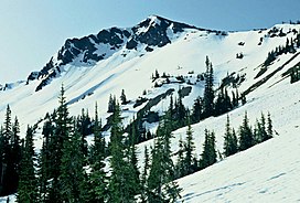
33:Sentinel Peak in May 1992
26:
590:Parratt, Smitty (1984).
364:climate zone of western
332:from the peak drains to
115:47.7788213; -123.3422310
59:652 ft (199 m)
680:Sentinel Peak weather:
627:Hydrol. Earth Syst. Sci
353:
610:McNulty, Tim (2009).
351:
313:Olympic National Park
237:Olympic National Park
656:. pp. 249–259.
326:Seattle Mountaineers
233:Protected area
106: /
378:maritime influence
354:
39:Highest point
713:Olympic Mountains
682:Mountain Forecast
445:Olympic Mountains
362:marine west coast
338:Dosewallips River
301:Olympic Mountains
294:
293:
251:Olympic Mountains
730:
668:
667:
649:
643:
642:
622:
616:
615:
607:
596:
595:
587:
581:
580:
569:
563:
558:
552:
551:
549:
548:
524:
515:
514:
512:
511:
497:
488:
487:
476:
439:
437:Mountains portal
434:
433:
432:
352:Southwest aspect
328:. Precipitation
321:Sentinels Sister
305:Jefferson County
280:
246:
195:
181:
180:
174:
162:
148:
147:
141:
121:
120:
118:
117:
116:
111:
107:
104:
103:
102:
99:
31:
19:
738:
737:
733:
732:
731:
729:
728:
727:
693:
692:
677:
672:
671:
664:
651:
650:
646:
624:
623:
619:
609:
608:
599:
594:(1st ed.).
589:
588:
584:
571:
570:
566:
559:
555:
546:
544:
528:"Sentinel Peak"
526:
525:
518:
509:
507:
505:listsofjohn.com
499:
498:
491:
478:
477:
468:
463:
435:
430:
428:
425:
391:
374:orographic lift
346:
290:via Hayden Pass
278:
244:
200:
199:
198:
197:
196:
193:
192:
189:
188:
187:
186:
182:
165:
164:
163:
160:
159:
156:
155:
154:
153:
149:
114:
112:
108:
105:
100:
97:
95:
93:
92:
34:
17:
12:
11:
5:
736:
734:
726:
725:
720:
715:
710:
705:
695:
694:
691:
690:
684:
676:
675:External links
673:
670:
669:
662:
644:
617:
597:
582:
577:Peakbagger.com
564:
553:
516:
489:
484:Peakbagger.com
465:
464:
462:
459:
458:
457:
452:
447:
441:
440:
424:
421:
390:
387:
370:Weather fronts
345:
342:
292:
291:
282:
274:
273:
269:
268:
266:Wellesley Peak
260:
254:
253:
248:
240:
239:
234:
230:
229:
224:
220:
219:
214:
210:
209:
206:
202:
201:
190:
184:
183:
176:
175:
169:
168:
167:
166:
157:
151:
150:
143:
142:
136:
135:
134:
133:
132:
131:
128:
127:
123:
122:
90:
84:
83:
80:
74:
73:
70:Mount Claywood
67:
61:
60:
57:
51:
50:
47:
41:
40:
36:
35:
32:
24:
23:
15:
13:
10:
9:
6:
4:
3:
2:
735:
724:
721:
719:
716:
714:
711:
709:
706:
704:
701:
700:
698:
689:
686:PBase photo:
685:
683:
679:
678:
674:
665:
663:0-87842-160-2
659:
655:
648:
645:
640:
636:
633:: 1633–1644.
632:
628:
621:
618:
613:
606:
604:
602:
598:
593:
586:
583:
578:
574:
568:
565:
562:
557:
554:
543:
539:
535:
534:
529:
523:
521:
517:
506:
502:
496:
494:
490:
485:
481:
475:
473:
471:
467:
460:
456:
453:
451:
448:
446:
443:
442:
438:
427:
422:
420:
418:
414:
410:
406:
403:
399:
396:
388:
386:
383:
379:
375:
371:
367:
366:North America
363:
359:
356:Based on the
350:
343:
341:
339:
335:
331:
327:
322:
318:
314:
310:
306:
302:
298:
297:Sentinel Peak
289:
286:
283:
281:
279:Easiest route
275:
270:
267:
264:
261:
259:
255:
252:
249:
247:
241:
238:
235:
231:
228:
225:
221:
218:
215:
211:
208:United States
207:
203:
185:Sentinel Peak
173:
152:Sentinel Peak
140:
129:
124:
119:
91:
89:
85:
81:
79:
75:
71:
68:
66:
62:
58:
56:
52:
48:
46:
42:
37:
30:
25:
22:Sentinel Peak
20:
653:
647:
630:
626:
620:
611:
591:
585:
576:
567:
556:
545:. Retrieved
531:
508:. Retrieved
504:
483:
392:
355:
320:
317:Mount Fromme
296:
295:
288:class 1
265:
245:Parent range
417:Pleistocene
385:this peak.
113: /
101:123°20′32″W
88:Coordinates
65:Parent peak
697:Categories
547:2019-10-08
510:2020-08-26
461:References
334:Hood Canal
309:Washington
217:Washington
98:47°46′44″N
72:(6,836 ft)
55:Prominence
639:1027-5606
409:turbidite
405:sandstone
382:avalanche
227:Jefferson
126:Geography
78:Isolation
45:Elevation
423:See also
413:basaltic
395:obducted
336:via the
272:Climbing
258:Topo map
398:clastic
389:Geology
344:Climate
205:Country
660:
637:
411:, and
402:Eocene
330:runoff
285:Hiking
223:County
303:, in
213:State
658:ISBN
635:ISSN
263:USGS
307:of
699::
631:11
629:.
600:^
575:.
540:,
536:.
530:.
519:^
503:.
492:^
482:.
469:^
407:,
368:.
340:.
666:.
641:.
579:.
550:.
513:.
486:.
Text is available under the Creative Commons Attribution-ShareAlike License. Additional terms may apply.