105:
112:
454:
299:
282:
29:
269:
Close to the peak stands a monument to those who died in the battles. Hill 705 was a key position to control the Serra de Pàndols range at the time of the Battle of the Ebro. The summit lies within the
61:
491:
104:
515:
510:
520:
420:
484:
413:
El diari de guerra de Lluís Randé i Inglés; Batalles del Segre i de l’Ebre i camps de concentració (abril 1938 - juliol 1939)
392:
432:
54:
477:
335:
212:
155:
303:
330:
263:
167:
325:
137:
320:
255:
378:
El parc eòlic de les Serres de Pàndols i
Cavalls. Energia, valors ambientals i memòria històrica
416:
380:(Ed.). 2003. Aquí, No! Els conflictes territorials a Catalunya. Barcelona: Editorial Empúries.
289:
259:
235:
196:
231:
396:
461:
271:
148:
453:
504:
227:
184:
442:
389:
298:
281:
28:
76:
63:
246:
The ridge's highest point is Punta Alta (705.5 m). This summit was known as
216:
208:
172:
433:
Serres de Pàndols-Cavalls, proposta d'ampliació del Parc
Natural del Port
437:
192:
285:
44:
220:
141:
355:
292:
258:, the bloodiest and most protracted series of combats in the
465:
262:(1936–39). The Battle was also the last action of the
238:
mountain range is located to the south of this range.
183:
178:
166:
161:
147:
133:
92:
53:
43:
38:
21:
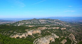
211:mountain chain located at the southern end of the
460:This article about a location in Catalonia is a
485:
8:
492:
478:
18:
302:Monument to those who died defending the
297:
280:
266:, who were withdrawn midway through it.
234:which has met with public protests. The
230:on the Serra de Pàndols and neighboring
111:
347:
7:
450:
448:
358:. Institut Cartogràfic de Catalunya
33:Serra de Pàndols seen from Hill 705
306:in the battles located on Hill 705
14:
390:The Battle of the Ebro in one day
452:
438:Pinell de Brai Town Hall Webpage
110:
103:
27:
356:"Mapa Topogràfic de Catalunya"
226:There is a project to install
1:
516:Military history of Catalonia
376:Edmon Castell i Oriol Nel·lo
511:Mountain ranges of Catalonia
464:. You can help Knowledge by
537:
447:
290:British volunteer soldiers
278:
49:705 m (2,313 ft)
521:Catalonia geography stubs
336:Catalan Pre-Coastal Range
213:Catalan Pre-Coastal Range
156:Catalan Pre-Coastal Range
97:
26:
77:41.0204667°N 0.4577444°E
16:Mountain chain in Spain
411:Jaume Aguadé i Sordé,
331:International Brigades
307:
293:
264:International Brigades
326:11th Division (Spain)
301:
284:
82:41.0204667; 0.4577444
443:La Batalla de l'Ebre
288:plaque honoring the
73: /
395:2011-07-19 at the
321:Battle of the Ebro
308:
294:
256:Battle of the Ebro
39:Highest point
473:
472:
312:
311:
260:Spanish Civil War
202:
201:
197:El Pinell de Brai
528:
494:
487:
480:
456:
449:
399:
387:
381:
374:
368:
367:
365:
363:
352:
304:Spanish Republic
277:
276:
274:municipal term.
232:Serra de Cavalls
205:Serra de Pàndols
187:
151:
124:Catalonia, Spain
118:Serra de Pàndols
114:
113:
107:
88:
87:
85:
84:
83:
78:
74:
71:
70:
69:
66:
31:
22:Serra de Pàndols
19:
536:
535:
531:
530:
529:
527:
526:
525:
501:
500:
499:
498:
429:
408:
403:
402:
397:Wayback Machine
388:
384:
375:
371:
361:
359:
354:
353:
349:
344:
317:
244:
185:
149:
129:
128:
127:
126:
125:
122:
121:
120:
119:
115:
81:
79:
75:
72:
67:
64:
62:
60:
59:
34:
17:
12:
11:
5:
534:
532:
524:
523:
518:
513:
503:
502:
497:
496:
489:
482:
474:
471:
470:
457:
446:
445:
440:
435:
428:
427:External links
425:
424:
423:
407:
404:
401:
400:
382:
369:
346:
345:
343:
340:
339:
338:
333:
328:
323:
316:
313:
310:
309:
295:
272:Pinell de Brai
243:
240:
236:Serra de Paüls
200:
199:
189:
181:
180:
176:
175:
170:
164:
163:
159:
158:
153:
145:
144:
135:
131:
130:
123:
117:
116:
109:
108:
102:
101:
100:
99:
98:
95:
94:
90:
89:
57:
51:
50:
47:
41:
40:
36:
35:
32:
24:
23:
15:
13:
10:
9:
6:
4:
3:
2:
533:
522:
519:
517:
514:
512:
509:
508:
506:
495:
490:
488:
483:
481:
476:
475:
469:
467:
463:
458:
455:
451:
444:
441:
439:
436:
434:
431:
430:
426:
422:
421:84-9791-082-6
418:
414:
410:
409:
405:
398:
394:
391:
386:
383:
379:
373:
370:
357:
351:
348:
341:
337:
334:
332:
329:
327:
324:
322:
319:
318:
314:
305:
300:
296:
291:
287:
283:
279:
275:
273:
267:
265:
261:
257:
254:) during the
253:
249:
241:
239:
237:
233:
229:
228:wind turbines
224:
222:
218:
214:
210:
206:
198:
194:
190:
188:
186:Easiest route
182:
177:
174:
171:
169:
168:Mountain type
165:
160:
157:
154:
152:
146:
143:
139:
136:
132:
106:
96:
91:
86:
68:00°27′27.88″E
65:41°01′13.68″N
58:
56:
52:
48:
46:
42:
37:
30:
25:
20:
466:expanding it
459:
415:, El Tinter
412:
406:Bibliography
385:
377:
372:
360:. Retrieved
350:
268:
251:
247:
245:
225:
204:
203:
150:Parent range
362:9 September
191:Drive from
80: /
55:Coordinates
505:Categories
342:References
138:Terra Alta
217:Catalonia
209:limestone
173:Limestone
93:Geography
45:Elevation
393:Archived
315:See also
252:Cota 705
248:Hill 705
242:Hill 705
179:Climbing
134:Location
193:Gandesa
162:Geology
419:
286:Bronze
221:Spain
215:, in
207:is a
142:Spain
462:stub
417:ISBN
364:2010
195:or
507::
223:.
219:,
140:,
493:e
486:t
479:v
468:.
366:.
250:(
Text is available under the Creative Commons Attribution-ShareAlike License. Additional terms may apply.