60:
52:
178:
219:
243:
21:
163:
212:
238:
205:
105:
143:
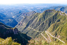
112:, and its highest point is situated at 1,460 metres (4,790 feet) above sea level. In the highest areas of this place, the
59:
95:
185:
148:
91:
63:
109:
78:
51:
133:
177:
138:
189:
113:
87:
232:
101:. It is crossed by the road SC-390, with remarkable landscapes and deep cliffs.
116:, located about 100 km (62 mi) away, can be spotted on clear days.
36:
23:
98:
117:
58:
121:
104:
This mountain range is situated between the municipalities of
193:
164:Guide of the municipality of Bom Jardim da Serra
213:
8:
220:
206:
90:located in the southeast of the state of
84:Mountain Range of the River of the Track
50:
16:Mountain range in Santa Catarina, Brazil
244:Santa Catarina (state) geography stubs
77:
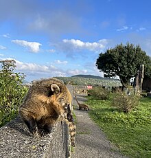
66:at the peak of Serra do Rio do Rastro
55:Road SC-390 in Serra do Rio do Rastro
7:
174:
172:
14:
176:
124:can occur in the highest areas.
188:, Brazil location article is a
79:[ˈsɛʁɐduˈʁiuduˈʁastɾu]
1:
144:Pedra Furada (Santa Catarina)
192:. You can help Knowledge by
260:
171:
239:Mountain ranges of Brazil
75:Portuguese pronunciation:
149:Rio do Rasto Formation
71:Serra do Rio do Rastro
67:
56:
62:
54:
37:28.40722°S 49.54611°W
42:-28.40722; -49.54611
110:Bom Jardim da Serra
33: /
134:Morro da Boa Vista
68:
57:
201:
200:
251:
222:
215:
208:
180:
173:
162:
81:
76:
48:
47:
45:
44:
43:
38:
34:
31:
30:
29:
26:
259:
258:
254:
253:
252:
250:
249:
248:
229:
228:
227:
226:
169:
161:(in Portuguese)
160:
157:
139:Morro da Igreja
130:
120:are common and
74:
41:
39:
35:
32:
27:
24:
22:
20:
19:
17:
12:
11:
5:
257:
255:
247:
246:
241:
231:
230:
225:
224:
217:
210:
202:
199:
198:
186:Santa Catarina
181:
167:
166:
156:
155:External links
153:
152:
151:
146:
141:
136:
129:
126:
114:Atlantic Ocean
92:Santa Catarina
88:mountain range
15:
13:
10:
9:
6:
4:
3:
2:
256:
245:
242:
240:
237:
236:
234:
223:
218:
216:
211:
209:
204:
203:
197:
195:
191:
187:
182:
179:
175:
170:
165:
159:
158:
154:
150:
147:
145:
142:
140:
137:
135:
132:
131:
127:
125:
123:
119:
115:
111:
107:
102:
100:
97:
93:
89:
85:
80:
72:
65:
61:
53:
49:
46:
194:expanding it
183:
168:
106:Lauro Müller
103:
83:
82:, literally
70:
69:
18:
40: /
233:Categories
28:49°32′46″W
25:28°24′26″S
122:snowfalls
128:See also
96:Southern
86:) is a
118:Frosts
99:Brazil
184:This
64:Coati
190:stub
108:and
235::
94:,
221:e
214:t
207:v
196:.
73:(
Text is available under the Creative Commons Attribution-ShareAlike License. Additional terms may apply.