259:
45:
61:
68:
302:
coastal highway, 40 kilometres (25 mi) south of
Florianópolis, and was opened on 6 June 1978. The visitor's centre includes a conference room and a gazebo from which the tops of the trees can be viewed. There is a 1 kilometre (0.62 mi) ecological trail where visitors are given guided tours.
294:
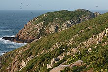
beach on the tip of Santa
Catarina Island has become a tourism and recreation site. It can be reached by boat or by hiking along a trail through the secondary-growth forest. The hike from the end of the bus line takes about two hours each way along a path through subtropical rainforest thick with
266:
When the state park was created the environmental authorities expelled some traditional fishing and farming families. Others were allowed to stay under strict conditions for land use. Comparison of aerial photographs of the portion of the park in
Florianopolis from 1957 and 1998 show after the
194:
The Serra do
Tabuleiro State Park is named after the Serra do Tabuleiro, a tabular mountain that is a prominent feature. The Serra do Tabuleiro is one of Santa Catarina's Eastern Mountain Ranges, others being the Mar de Morros and part of the Serra do Mar. It covers an area of 84,130 hectares
270:
The park contains five of the six main plant formations of the
Atlantic Forest biome. The coastal area contains salt marshes and mangroves. The mountains are mostly covered in dense rainforest rich in
539:
250:
rivers, which supply most of the drinking water for greater
Florianópolis and the south coast region. The basin of the Massiambu River is fully contained within the park.
298:
The headquarters and visitor centre are in Palhoça and there are two thematic centres in the municipal seats of Imarui and São Bonifácio. The headquarters is on the
258:
290:
The park is readily accessible to residents of the nearby urban areas, and supports eco-tourism and environmental education as well as scientific research. The
186:, which is an important source of drinking water. It also protects some coastal islands. The park is used for scientific research, education and eco-tourism.
544:
96:
60:
227:. It includes the islands of Fortaleza/Araçatuba, Andrade, Papagaio Pequeno, Três Irmãs, Moleques do Sul, Siriú, Coral, Cardos and the south tip of
234:
The park was established by decree 1.260 in 1975. The purpose was to protect the rich biodiversity of the region and the water sources for greater
243:
282:, a formation of semi-circular sand ridges formed by fluctuations in sea levels over the years and considered an important geological monument.
529:
465:
439:
303:
There is a program to restore the animals that once lived in the
Baixada do Massiambu but have since vanished. Animals such as
216:
534:
30:
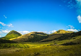
274:. The upper slopes, shrouded in fog from the moist Atlantic air, holds cloud forest. The highest parts hold rainforest with
84:
44:
278:
and alpine meadows. Each region has its own special fauna and flora, as do the coastal islands. The park contains the
524:
204:
239:
480:
179:
228:
368:
366:
364:
362:
175:
167:
139:
212:
461:
455:
435:
429:
235:
196:
183:
311:
that have been taken from hunters are held in semi-captivity in preparation for release.
208:
337:
335:
333:
331:
329:
327:
325:
323:
247:
518:
372:
34:
182:, Brazil. It protects a mountainous area near the city of Florianópolis, covered in
224:
267:
abandonment of farming there has been substantial regeneration of the forest.
200:
111:
98:
496:
275:
220:
341:
308:
271:
431:
Forest
Recovery and Just Sustainability in the Florianopolis City-region
299:
304:
257:
411:
238:, Santa Catarina. The lush forests protect the sources of the
383:
381:
373:
Parque
Estadual da Serra do Tabuleiro – Ponta do Papagaio
67:
153:
145:
135:
127:
90:
80:
18:
485:(in Portuguese), FATMA: Fundação do meio Ambiente
342:Parque Estadual da Serra do Tabuleiro – FATMA
8:
15:
540:Protected areas of Santa Catarina (state)
195:(207,900 acres) in the municipalities of
399:
387:
353:
497:"Parque Estadual da Serra do Tabuleiro"
319:
482:Parque Estadual da Serra do Tabuleiro
172:Parque Estadual da Serra do Tabuleiro
24:Parque Estadual da Serra do Tabuleiro
7:
454:Fodor's Travel Publications (2012),
545:Protected areas established in 1975
14:
428:Baptista, Sandra Regina (2008),
412:Fodor's Travel Publications 2012
157:FATMA: Fundação do meio Ambiente
66:
59:
43:
460:, Fodor's Travel Publications,
144:
131:84,130 hectares (207,900 acres)
79:
1:
530:1975 establishments in Brazil
164:Serra do Tabuleiro State Park
19:Serra do Tabuleiro State Park
561:
205:Santo Amaro da Imperatriz
54:
42:
28:
23:
262:Moleques do Sul islands.
85:São José, Santa Catarina
49:Serra do Tabuleiro hills
457:Fodor's See It: Brazil
263:
171:
535:State parks of Brazil
292:Praia dos Naufragados
261:
229:Santa Catarina Island
280:Baixada do Maciambu
108: /
402:, p. 220–221.
264:
501:Ponta do Papagaio
467:978-0-87637-147-3
441:978-1-109-06209-0
161:
160:
112:27.914°S 48.805°W
81:Nearest city
552:
525:IUCN Category II
510:
509:
508:
492:
491:
490:
476:
475:
474:
450:
449:
448:
415:
409:
403:
397:
391:
385:
376:
370:
357:
351:
345:
339:
178:in the state of
123:
122:
120:
119:
118:
117:-27.914; -48.805
113:
109:
106:
105:
104:
101:
70:
69:
63:
47:
16:
560:
559:
555:
554:
553:
551:
550:
549:
515:
514:
513:
506:
504:
503:(in Portuguese)
495:
488:
486:
479:
472:
470:
468:
453:
446:
444:
442:
427:
423:
418:
410:
406:
398:
394:
386:
379:
371:
360:
352:
348:
340:
321:
317:
288:
256:
240:Vargem do Braço
192:
184:Atlantic Forest
116:
114:
110:
107:
102:
99:
97:
95:
94:
76:
75:
74:
73:
72:
71:
50:
38:
12:
11:
5:
558:
556:
548:
547:
542:
537:
532:
527:
517:
516:
512:
511:
493:
477:
466:
451:
440:
424:
422:
419:
417:
416:
414:, p. 172.
404:
392:
390:, p. 221.
377:
358:
346:
318:
316:
313:
287:
284:
255:
252:
191:
188:
180:Santa Catarina
159:
158:
155:
151:
150:
147:
143:
142:
137:
133:
132:
129:
125:
124:
92:
88:
87:
82:
78:
77:
65:
64:
58:
57:
56:
55:
52:
51:
48:
40:
39:
29:
26:
25:
21:
20:
13:
10:
9:
6:
4:
3:
2:
557:
546:
543:
541:
538:
536:
533:
531:
528:
526:
523:
522:
520:
502:
498:
494:
484:
483:
478:
469:
463:
459:
458:
452:
443:
437:
433:
432:
426:
425:
420:
413:
408:
405:
401:
400:Baptista 2008
396:
393:
389:
388:Baptista 2008
384:
382:
378:
374:
369:
367:
365:
363:
359:
356:, p. 62.
355:
354:Baptista 2008
350:
347:
343:
338:
336:
334:
332:
330:
328:
326:
324:
320:
314:
312:
310:
306:
301:
296:
293:
285:
283:
281:
277:
273:
268:
260:
253:
251:
249:
245:
241:
237:
236:Florianópolis
232:
230:
226:
222:
218:
214:
213:São Bonifácio
210:
206:
202:
198:
197:Florianópolis
189:
187:
185:
181:
177:
173:
169:
165:
156:
154:Administrator
152:
148:
141:
138:
134:
130:
126:
121:
93:
89:
86:
83:
62:
53:
46:
41:
36:
35:national park
32:
31:IUCN category
27:
22:
17:
505:, retrieved
500:
487:, retrieved
481:
471:, retrieved
456:
445:, retrieved
434:, ProQuest,
430:
407:
395:
349:
297:
291:
289:
279:
269:
265:
233:
217:São Martinho
209:Águas Mornas
193:
163:
162:
254:Environment
225:Paulo Lopes
136:Designation
115: /
91:Coordinates
519:Categories
507:2016-06-11
489:2016-06-11
473:2016-06-11
447:2016-06-11
176:state park
168:Portuguese
140:State park
103:48°48′18″W
100:27°54′50″S
309:capybaras
276:Araucaria
272:epiphytes
286:Visitors
190:Location
421:Sources
295:vines.
244:Cubatão
201:Palhoça
174:) is a
146:Created
464:
438:
305:tapirs
300:BR-101
221:Imaruí
315:Notes
248:D'Una
462:ISBN
436:ISBN
307:and
246:and
223:and
149:1975
128:Area
33:II (
521::
499:,
380:^
361:^
322:^
242:,
231:.
219:,
215:,
211:,
207:,
203:,
199:,
170::
375:.
344:.
166:(
37:)
Text is available under the Creative Commons Attribution-ShareAlike License. Additional terms may apply.