836:
135:
38:
389:, the five smaller islands of Ounḏa Dâbali, H̱amra, Tolka, H̱orod le ‘Ale and Ounḏa Kômaytou, as well as small rock outcrops that are uninhabitable for humans but important for seabirds. The sky is always clear and bright throughout the year. The climate of Seven Brothers Islands is classified in the
901:
877:
349:
All the islets are surrounded by reefs. All are brownish, except Big Island which is yellowish. There is a masonry marker on the summit of Big Island.
906:
750:
694:
69:
916:
385:
The warmest month of the year is July with an average temperature of 39.0 °C. The archipelago consists of the main island of
390:
870:
797:
896:
863:
773:
386:
296:
722:
911:
362:
166:
161:
149:
374:
370:
358:
393:
as BWh, meaning a desert climate with a mean annual temperature over 29 °C or 84 °F.
746:
690:
847:
684:
740:
218:
222:
329:
The "seventh brother" is not an island, but the volcanic hill at the northern tip of the
17:
210:
37:
890:
736:
195:
191:
57:
835:
206:
154:
726:, page 162. National Geospatial Intelligence Agency pub. 172. Accessed 2012-07-6.
366:
187:
340:
330:
812:
799:
84:
71:
343:
333:
843:
214:
140:
739:; University of Durham. International Boundaries Research Unit (2001).
346:
and 6.0 kilometres (3.7 mi) northeast from the coast of
Djibouti.
240:
202:
246:
spanning about 10 kilometres (6.2 mi) in a rough east-west line:
243:
198:
339:
West Island lies about 4.5 kilometres (2.8 mi) east from the
742:
Parting the Red Sea: boundaries, offshore resources and transit
851:
723:
Sailing
Directions (Enroute) - Red Sea and Persian Gulf
160:
148:
124:
116:
108:
100:
63:
53:
48:
683:Alwan, Daoud Aboubaker; Mibrathu, Yohanis (2000).
221:publications, the group is often called by its
871:
8:
30:
878:
864:
396:
217:, and are a notable diving site. Even in
29:
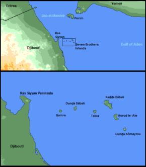
239:The archipelago proper is a chain of six
400:Climate data for Seven Brothers Islands
902:Important Bird Areas of Red Sea islands
675:
357:The archipelago has been designated an
717:
715:
713:
7:
832:
830:
112:1.02 km (0.39 sq mi)
850:. You can help Knowledge (XXG) by
25:
689:. Scarecrow Press. pp. 47–.
686:Historical dictionary of Djibouti
907:Important Bird Areas of Djibouti
834:
133:
36:
780:. BirdLife International. 2024
1:
589:Average rainfall mm (inches)
391:Köppen climate classification
519:Mean daily minimum °C (°F)
449:Mean daily maximum °C (°F)
933:
829:
658:
399:
588:
518:
448:
443:
440:
437:
434:
431:
428:
425:
422:
419:
416:
413:
410:
407:
404:
129:
44:
35:
917:Djibouti geography stubs
120:114 m (374 ft)
18:Seven Brothers (islands)
209:). They are within the
846:location article is a
365:because it supports a
363:BirdLife International
176:Seven Brothers Islands
117:Highest elevation
31:Seven Brothers Islands
745:. IBRU. pp. 8–.
375:greater crested terns
85:12.46278°N 43.40167°E
178:, also known as the
897:Islands of Djibouti
813:12.4606°N 43.4242°E
809: /
359:Important Bird Area
353:Important Bird Area
81: /
32:
778:BirdLife Data Zone
90:12.46278; 43.40167
27:Island of Djibouti
859:
858:
774:"Les Sept Frères"
752:978-1-897643-46-4
737:Dzurek, Daniel J.
696:978-0-8108-3873-4
666:
665:
172:
171:
16:(Redirected from
924:
880:
873:
866:
838:
831:
824:
823:
821:
820:
819:
818:12.4606; 43.4242
814:
810:
807:
806:
805:
802:
789:
788:
786:
785:
770:
764:
763:
761:
759:
733:
727:
719:
708:
707:
705:
703:
680:
397:
139:
137:
136:
96:
95:
93:
92:
91:
86:
82:
79:
78:
77:
74:
40:
33:
21:
932:
931:
927:
926:
925:
923:
922:
921:
887:
886:
885:
884:
827:
817:
815:
811:
808:
803:
800:
798:
796:
795:
793:
792:
783:
781:
772:
771:
767:
757:
755:
753:
735:
734:
730:
720:
711:
701:
699:
697:
682:
681:
677:
672:
667:
653:
648:
643:
638:
633:
628:
623:
618:
613:
608:
603:
598:
593:
583:
578:
573:
568:
563:
558:
553:
548:
543:
538:
533:
528:
523:
513:
508:
503:
498:
493:
488:
483:
478:
473:
468:
463:
458:
453:
383:
367:breeding colony
355:
322:‘Ounḏa Kômaytou
237:
194:section of the
144:
134:
132:
89:
87:
83:
80:
75:
72:
70:
68:
67:
28:
23:
22:
15:
12:
11:
5:
930:
928:
920:
919:
914:
909:
904:
899:
889:
888:
883:
882:
875:
868:
860:
857:
856:
839:
791:
790:
765:
751:
728:
709:
695:
674:
673:
671:
668:
664:
663:
656:
655:
650:
645:
640:
635:
630:
625:
620:
615:
610:
605:
600:
595:
590:
586:
585:
580:
575:
570:
565:
560:
555:
550:
545:
540:
535:
530:
525:
520:
516:
515:
510:
505:
500:
495:
490:
485:
480:
475:
470:
465:
460:
455:
450:
446:
445:
442:
439:
436:
433:
430:
427:
424:
421:
418:
415:
412:
409:
406:
402:
401:
395:
382:
379:
354:
351:
327:
326:
314:
310:H̱orod le ‘Ale
302:
288:
276:
264:
236:
233:
211:Obock District
180:Sawabi Islands
170:
169:
164:
158:
157:
152:
146:
145:
130:
127:
126:
125:Administration
122:
121:
118:
114:
113:
110:
106:
105:
102:
98:
97:
65:
61:
60:
55:
51:
50:
46:
45:
42:
41:
26:
24:
14:
13:
10:
9:
6:
4:
3:
2:
929:
918:
915:
913:
912:Bab-el-Mandeb
910:
908:
905:
903:
900:
898:
895:
894:
892:
881:
876:
874:
869:
867:
862:
861:
855:
853:
849:
845:
840:
837:
833:
828:
825:
822:
779:
775:
769:
766:
754:
748:
744:
743:
738:
732:
729:
725:
724:
718:
716:
714:
710:
698:
692:
688:
687:
679:
676:
669:
662:
661:World Weather
657:
651:
646:
641:
636:
631:
626:
621:
616:
611:
606:
601:
596:
591:
587:
581:
576:
571:
566:
561:
556:
551:
546:
541:
536:
531:
526:
521:
517:
511:
506:
501:
496:
491:
486:
481:
476:
471:
466:
461:
456:
451:
447:
403:
398:
394:
392:
388:
380:
378:
376:
372:
368:
364:
360:
352:
350:
347:
345:
342:
337:
335:
332:
324:
323:
318:
315:
312:
311:
306:
303:
301:), 114 m high
300:
299:
298:
292:
289:
286:
285:
280:
277:
274:
273:
268:
267:Double Island
265:
262:
261:
256:
252:
249:
248:
247:
245:
242:
234:
232:
230:
229:
224:
220:
216:
212:
208:
204:
201:(between the
200:
197:
196:Bab-el-Mandeb
193:
192:Dact-el-Mayun
189:
185:
181:
177:
168:
165:
163:
159:
156:
153:
151:
147:
143:
142:
128:
123:
119:
115:
111:
107:
103:
101:Total islands
99:
94:
66:
62:
59:
58:Bab-el-Mandeb
56:
52:
47:
43:
39:
34:
19:
852:expanding it
841:
826:
794:
782:. Retrieved
777:
768:
756:. Retrieved
741:
731:
721:
700:. Retrieved
685:
678:
660:
387:Kaḏḏa Dâbali
384:
356:
348:
338:
328:
325:), 47 m high
321:
320:
317:South Island
316:
313:), 83 m high
309:
308:
304:
297:Kaḏḏa Dâbali
295:
294:
290:
287:), 17 m high
283:
282:
278:
275:), 46 m high
272:Ounḏa Dâbali
271:
270:
266:
263:), 62 m high
259:
258:
254:
250:
238:
227:
226:
207:Gulf of Aden
184:Seba Islands
183:
179:
175:
173:
131:
816: /
305:East Island
251:West Island
228:Sept Frères
188:archipelago
88: /
64:Coordinates
891:Categories
804:43°25′27″E
801:12°27′38″N
784:2024-09-08
670:References
331:Ras Siyyan
291:Big Island
279:Low Island
255:Red Island
167:Khor Angar
76:43°24′06″E
73:12°27′46″N
361:(IBA) by
344:peninsula
334:peninsula
235:Geography
49:Geography
844:Djibouti
659:Source:
489:(100.9)
484:(102.2)
479:(100.8)
241:volcanic
215:Djibouti
205:and the
186:, is an
162:District
141:Djibouti
54:Location
584:(79.4)
579:(72.9)
574:(74.8)
569:(79.7)
564:(85.1)
559:(84.9)
554:(86.4)
549:(86.2)
544:(82.2)
539:(78.4)
534:(75.9)
529:(74.1)
524:(72.7)
514:(93.3)
509:(86.5)
504:(89.2)
499:(93.9)
494:(98.8)
474:(96.1)
469:(91.8)
464:(88.5)
459:(85.6)
454:(85.6)
381:Climate
244:islands
219:English
203:Red Sea
190:in the
758:28 May
749:
702:28 May
693:
654:(2.2)
649:(0.2)
644:(0.2)
639:(0.2)
634:(0.5)
629:(0.2)
624:(0.2)
614:(0.0)
609:(0.2)
604:(0.2)
599:(0.1)
594:(0.2)
405:Month
371:lesser
341:Siyyan
260:H̱amra
225:name,
223:French
199:strait
150:Region
138:
842:This
444:Year
284:Tolka
253:, or
155:Obock
848:stub
760:2011
747:ISBN
704:2011
691:ISBN
619:(0)
582:26.4
577:22.7
572:23.8
567:26.5
562:29.5
557:29.4
552:30.2
547:30.1
542:27.9
537:25.8
532:24.4
527:23.4
522:22.6
512:34.1
507:30.3
502:31.8
497:34.4
492:37.1
487:38.3
482:39.0
477:38.2
472:35.6
467:33.2
462:31.4
457:29.8
452:29.8
441:Dec
438:Nov
435:Oct
432:Sep
429:Aug
426:Jul
423:Jun
420:May
417:Apr
414:Mar
411:Feb
408:Jan
373:and
174:The
109:Area
377:.
369:of
213:of
182:or
893::
776:.
712:^
652:53
632:12
336:.
231:.
879:e
872:t
865:v
854:.
787:.
762:.
706:.
647:4
642:4
637:4
627:6
622:5
617:0
612:1
607:4
602:6
597:3
592:4
319:(
307:(
293:(
281:(
269:(
257:(
104:6
20:)
Text is available under the Creative Commons Attribution-ShareAlike License. Additional terms may apply.