45:
72:
29:
52:
557:
287:, i.e. one hundred million, which is possibly the largest Reynolds number regularly attained in natural water channels on Earth (the current speed is about 8 m/s, 26 ft/s, the nominal depth about 100 m, 330 ft). Turbulence develops usually around a Reynolds number of 2000, depending on the geometric structure of the channel.
598:
632:
444:
591:
44:
319:
was one of the rock's first recorded victims. On April 5, 1958, after twenty-seven months of tunneling and engineering work, Ripple Rock was blown up with 1,375 tons of
312:
mountain that lay just nine feet beneath the surface of
Seymour Narrows. It was a serious hazard to shipping, sinking 119 vessels and taking 114 lives. The gunboat
285:
584:
622:
617:
482:
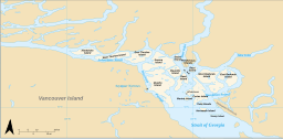
216:. For most of the length of the narrows, the channel is about 750 metres (820 yd) wide. Through this narrow channel, currents can reach 15
106:
627:
229:
208:. The section known as Seymour Narrows begins about 18 km (11 mi) from the south end of Discovery Passage where it enters the
404:
213:
205:
505:
197:
335:
564:
520:
479:
376:
256:
Seymour
Narrows is notable also because the flowing current can be sufficiently turbulent to realize a
350:
334:
The event was broadcast live on
Canadian television. The footage is also regularly screened at the
313:
71:
400:
328:
185:
153:
77:
28:
456:
393:
263:
237:
193:
189:
88:
486:
345:
257:
233:
568:
209:
611:
371:
201:
138:
515:
509:
531:
419:
303:
241:
217:
460:
291:
121:
108:
341:
324:
309:
327:
making it the largest commercial, non-nuclear blast in North
America. The
244:
was removed, it remains a challenging route. In March 1981, the freighter
320:
536:
556:
143:
92:
240:
as "one of the vilest stretches of water in the world." Even after
348:
wrote a song about the event and released it on their 2004 album
192:
known for strong tidal currents. Discovery
Passage lies between
290:
Seymour
Narrows delineates part of the northern extent of the
236:
from 1844 to 1848. Seymour
Narrows was described by Captain
521:
Ripple Rock blown up – Unforgettable
Moments – CBC Archives
526:
204:
except at its northern end where the eastern shoreline is
572:
16:
Section of
Discovery Passage, British Columbia, Canada
266:
331:
in 1917 was larger but it was not a deliberate act.
171:
163:
159:
149:
137:
98:
84:
21:
392:
279:
633:Central Coast of British Columbia geography stubs
480:Environmental History and Features of Puget Sound
99:
496:Canadian Tide and Current Tables, Vol. 6, 2003
184:is a 5-kilometre (3.1 mi) section of the
592:
8:
399:(3rd, 1997 ed.), Vancouver: UBC Press,
599:
585:
33:Approaching Seymour Narrows from the north
18:
445:"Turbulence spectra from a tidal channel"
443:Grant HL, Stewart RW, Moilliet A (1962).
391:Akrigg, G.P.V.; Akrigg, Helen B. (1986),
271:
265:
544:, in the New York Times, March 18, 1981
516:Ripple Rock Explosion, Vancouver Island
363:
230:Rear Admiral Sir George Francis Seymour
51:
527:Campbell River Museum official website
563:This article about a location on the
7:
553:
551:
420:"B.C.'s deadly Ripple Rock blown up"
76:Location of Seymour Narrows in the
623:Landforms of the Discovery Islands
14:
618:Central Coast of British Columbia
565:Central Coast of British Columbia
555:
70:
50:
43:
27:
170:
162:
1:
220:(28 km/h; 17 mph).
198:Menzies Bay, British Columbia
83:
571:. You can help Knowledge by
395:British Columbia Place Names
308:Ripple Rock was a submerged
248:ran aground in the narrows.
628:Straits of British Columbia
542:Freighter Aground in Canada
506:Overview of Seymour Narrows
228:The narrows were named for
649:
550:
537:Navigating Seymour Narrows
449:Journal of Fluid Mechanics
301:
461:10.1017/S002211206200018X
69:
38:
26:
175:100 m (330 ft)
167:750 metres (820 yd)
281:
280:{\displaystyle 10^{8}}
377:BC Geographical Names
336:Campbell River Museum
282:
264:
122:50.1367°N 125.3533°W
118: /
485:2009-05-13 at the
277:
232:who commanded the
127:50.1367; -125.3533
580:
579:
372:"Seymour Narrows"
329:Halifax Explosion
186:Discovery Passage
179:
178:
154:Discovery Passage
78:Discovery Islands
640:
601:
594:
587:
559:
552:
532:Ripple Rock page
490:
477:
471:
470:
468:
467:
440:
434:
433:
431:
430:
424:
416:
410:
409:
398:
388:
382:
381:
368:
286:
284:
283:
278:
276:
275:
238:George Vancouver
194:Vancouver Island
190:British Columbia
133:
132:
130:
129:
128:
123:
119:
116:
115:
114:
111:
101:
89:British Columbia
74:
54:
53:
47:
31:
19:
648:
647:
643:
642:
641:
639:
638:
637:
608:
607:
606:
605:
548:
502:
494:
493:
487:Wayback Machine
478:
474:
465:
463:
442:
441:
437:
428:
426:
423:(CBC Broadcast)
422:
418:
417:
413:
407:
390:
389:
385:
370:
369:
365:
360:
346:The Evaporators
306:
300:
267:
262:
261:
258:Reynolds number
254:
246:Star Philippine
234:Pacific Station
226:
182:Seymour Narrows
126:
124:
120:
117:
112:
109:
107:
105:
104:
80:
65:
64:
63:
62:
61:
60:
59:
58:Seymour Narrows
55:
34:
22:Seymour Narrows
17:
12:
11:
5:
646:
644:
636:
635:
630:
625:
620:
610:
609:
604:
603:
596:
589:
581:
578:
577:
567:, Canada is a
560:
546:
545:
539:
534:
529:
524:
518:
513:
508:Archived from
501:
500:External links
498:
492:
491:
472:
455:(2): 241–268.
435:
411:
405:
383:
362:
361:
359:
356:
302:Main article:
299:
296:
274:
270:
253:
250:
225:
222:
214:Campbell River
210:Georgia Strait
177:
176:
173:
169:
168:
165:
161:
160:
157:
156:
151:
147:
146:
141:
135:
134:
102:
96:
95:
86:
82:
81:
75:
67:
66:
57:
56:
49:
48:
42:
41:
40:
39:
36:
35:
32:
24:
23:
15:
13:
10:
9:
6:
4:
3:
2:
645:
634:
631:
629:
626:
624:
621:
619:
616:
615:
613:
602:
597:
595:
590:
588:
583:
582:
576:
574:
570:
566:
561:
558:
554:
549:
543:
540:
538:
535:
533:
530:
528:
525:
522:
519:
517:
514:
512:on 2012-02-05
511:
507:
504:
503:
499:
497:
488:
484:
481:
476:
473:
462:
458:
454:
450:
446:
439:
436:
421:
415:
412:
408:
406:0-7748-0636-2
402:
397:
396:
387:
384:
379:
378:
373:
367:
364:
357:
355:
353:
352:
347:
343:
339:
337:
332:
330:
326:
322:
318:
317:
311:
305:
297:
295:
293:
288:
272:
268:
259:
251:
249:
247:
243:
239:
235:
231:
223:
221:
219:
215:
211:
207:
206:Sonora Island
203:
202:Quadra Island
199:
195:
191:
187:
183:
174:
172:Average depth
166:
158:
155:
152:
148:
145:
142:
140:
136:
131:
103:
97:
94:
90:
87:
79:
73:
68:
46:
37:
30:
25:
20:
573:expanding it
562:
547:
541:
510:the original
495:
489:, NOAA-NWFSC
475:
464:. Retrieved
452:
448:
438:
427:. Retrieved
425:. 1958-04-05
414:
394:
386:
375:
366:
349:
340:
333:
315:
307:
289:
255:
245:
227:
181:
180:
150:Part of
351:Ripple Rock
304:Ripple Rock
298:Ripple Rock
242:Ripple Rock
125: /
100:Coordinates
612:Categories
466:2024-06-26
429:2024-06-26
358:References
292:Salish Sea
164:Max. width
113:125°21.2′W
342:Vancouver
325:explosive
310:twin-peak
260:of about
252:Hydrology
224:Etymology
110:50°08.2′N
483:Archived
321:Nitramex
85:Location
523:(Video)
316:Saranac
403:
144:Strait
93:Canada
344:band
218:knots
212:near
569:stub
401:ISBN
314:USS
200:and
139:Type
457:doi
323:2H
196:at
188:in
614::
453:12
451:.
447:.
374:.
354:.
338:.
294:.
269:10
91:,
600:e
593:t
586:v
575:.
469:.
459::
432:.
380:.
273:8
Text is available under the Creative Commons Attribution-ShareAlike License. Additional terms may apply.