254:
82:
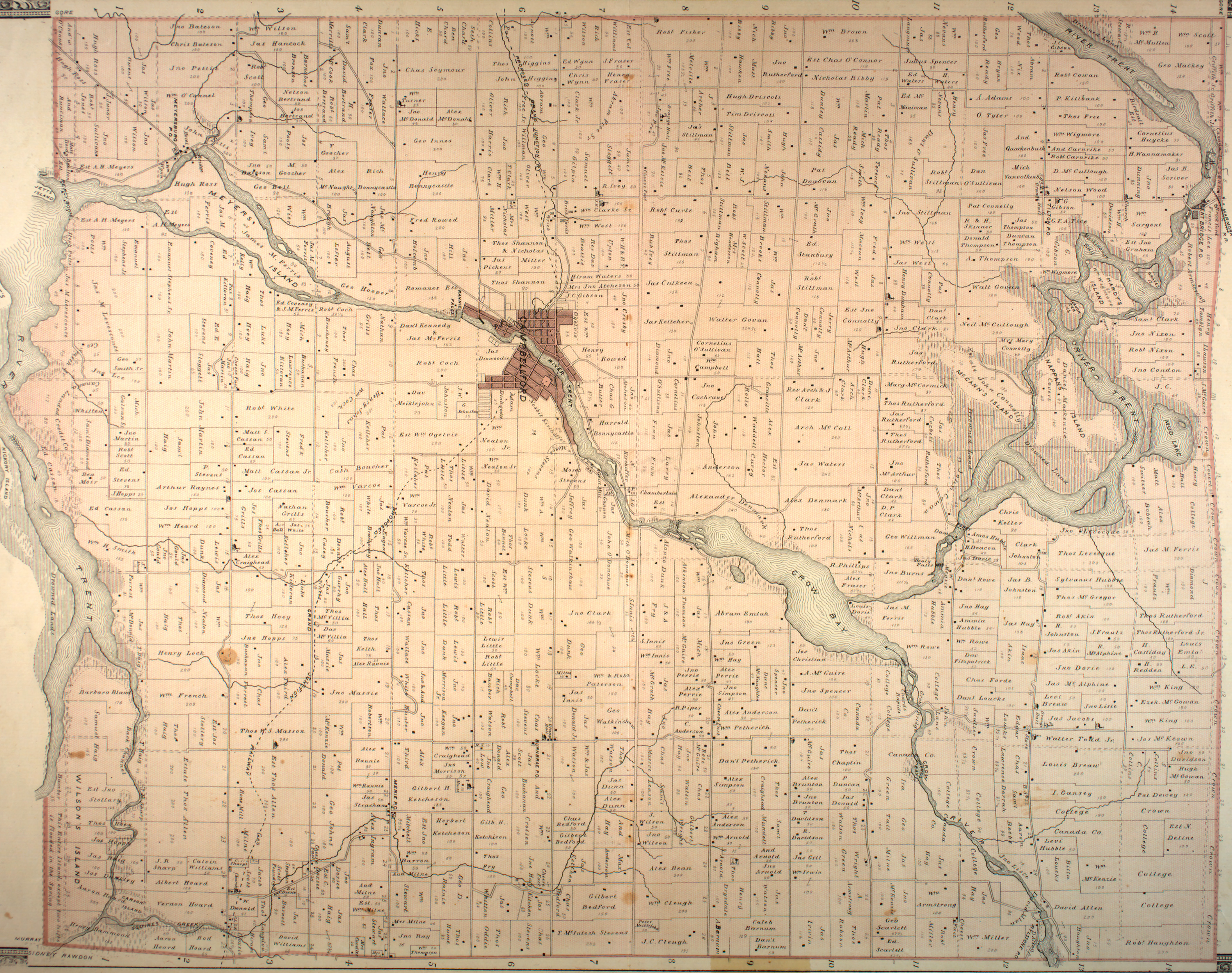
Prior to amalgamation, the
Township of Seymour consisted of the following villages, hamlets & communities such as Burnbrae, Campbellford, Clarke's, Hardy Island, Healey Falls, Kellers, Menie, Meyersburg, Mount Pleasant, Nappan Island, Percy Boom, Pethericks Corners and Rylstone.
53:
European settlement began in earnest in the 1830s and brothers
Lieutenant-Colonel Robert Campbell and Major Robert Campbell were granted 890 acres (360 ha) on the Trent River in 1831. A settlement grew, and in 1876, the Village of
73:
to form the Town of
Campbellford / Seymour, Percy & Hastings. It was renamed Trent Hills later that year. According to the 2001 Census, Seymour had a population of 4,528 at the time of amalgamation.
215:
62:
319:
183:
314:
324:
295:
65:, then Northumberland after the United Counties were restructured in 1974. In 2001, Seymour was amalgamated with Campbellford, the Village of
329:
288:
35:
142:
92:
281:
117:
122:
55:
47:
112:
153:
66:
31:
265:
17:
70:
177:
308:
253:
230:
217:
58:
was separated from
Seymour and incorporated as a separate municipality.
261:
39:
43:
207:
269:
184:Ontario Ministry of Municipal Affairs and Housing
172:
170:
46:. It is currently part of the Municipality of
289:
8:
179:Restructured municipalities - Ontario map #5
63:United Counties of Northumberland and Durham
30:is a former incorporated township and now a
320:Geography of Northumberland County, Ontario
296:
282:
315:Former township municipalities in Ontario
325:Populated places disestablished in 2001
104:
182:(Map). Restructuring Maps of Ontario.
7:
250:
248:
61:Seymour was originally part of the
268:. You can help Knowledge (XXG) by
25:
252:
1:
150:Canadian County Atlas Project
208:Trent Hills Official Website
118:Geographical Names Data Base
93:List of townships in Ontario
346:
247:
18:Seymour Township, Ontario
123:Natural Resources Canada
330:Ontario geography stubs
264:location article is a
231:44.33861°N 77.78167°W
143:"Township of Seymour"
36:Northumberland County
236:44.33861; -77.78167
227: /
32:geographic township
277:
276:
154:McGill University
71:Township of Percy
16:(Redirected from
337:
298:
291:
284:
256:
249:
242:
241:
239:
238:
237:
232:
228:
225:
224:
223:
220:
195:
194:
192:
191:
174:
165:
164:
162:
161:
147:
139:
133:
132:
130:
129:
109:
78:Populated places
21:
345:
344:
340:
339:
338:
336:
335:
334:
305:
304:
303:
302:
245:
235:
233:
229:
226:
221:
218:
216:
214:
213:
204:
199:
198:
189:
187:
176:
175:
168:
159:
157:
145:
141:
140:
136:
127:
125:
111:
110:
106:
101:
89:
80:
23:
22:
15:
12:
11:
5:
343:
341:
333:
332:
327:
322:
317:
307:
306:
301:
300:
293:
286:
278:
275:
274:
257:
211:
210:
203:
202:External links
200:
197:
196:
166:
134:
103:
102:
100:
97:
96:
95:
88:
85:
79:
76:
24:
14:
13:
10:
9:
6:
4:
3:
2:
342:
331:
328:
326:
323:
321:
318:
316:
313:
312:
310:
299:
294:
292:
287:
285:
280:
279:
273:
271:
267:
263:
258:
255:
251:
246:
243:
240:
209:
206:
205:
201:
185:
181:
180:
173:
171:
167:
155:
151:
144:
138:
135:
124:
120:
119:
114:
108:
105:
98:
94:
91:
90:
86:
84:
77:
75:
72:
68:
64:
59:
57:
51:
49:
45:
41:
37:
33:
29:
19:
270:expanding it
259:
244:
212:
188:. Retrieved
178:
158:. Retrieved
149:
137:
126:. Retrieved
116:
107:
81:
60:
56:Campbellford
52:
27:
26:
234: /
48:Trent Hills
34:located in
309:Categories
222:77°46′54″W
219:44°20′19″N
190:2014-05-10
160:2014-05-10
128:2014-05-10
99:References
113:"Seymour"
87:See also
69:and the
67:Hastings
262:Ontario
40:Ontario
28:Seymour
186:. 2006
156:. 2001
44:Canada
260:This
146:(JPG)
266:stub
311::
169:^
152:.
148:.
121:.
115:.
50:.
42:,
38:,
297:e
290:t
283:v
272:.
193:.
163:.
131:.
20:)
Text is available under the Creative Commons Attribution-ShareAlike License. Additional terms may apply.