42:
299:
307:
398:('peak of the yew'), a 1001 m peak that briefly gained Munro status in 1981 only to lose it again in 1997. When viewed from the ridge, Sgùrr an Iubhair appears to be a separate mountain, but both the above peaks are listed as "tops" of Sgùrr a' Mhàim in the Munro Tables. Sgùrr a' Mhàim's northern side contrasts to its southern flank (where the Devil's Ridge is). The northern slopes drop steeply to Glen Nevis, and there are two
655:
615:
411:
ridges which spring from the Allt Coire a' Mhàil above the An Steall Ban waterfall. Both these routes require some scrambling. A more circuitous ascent goes up to the head of Coire a' Mhusgain from
Achriabhach to cross the ridge to the summit. The summit cairn is substantial being made up of light coloured quartzite stones and gives a view of the southern side of
410:
From the northern flank, the mountain can be ascended directly using one of the three ridges that descend to the glen. The most popular of these is up the north west ridge from
Achriabhach where there is a carpark but it is also possible to ascend from upper Glen Nevis via the north east or east
383:. It is linked to the main spine of the Mamore group on its southern side by a feature called The Devil's Ridge, which is a one-kilometre undulating ridge with a few exposed sections which require care. The most difficult part is a rock gap known as 'The Bad Step' with Scottish hill walker
283:
206:
265:
903:
898:
583:
387:
commenting, "The ‘Bad Step’ on the ridge is perhaps exaggerated - it can be jumped across. If you missed of course, a couple of bounces would land you down in the corries".
41:
112:
310:
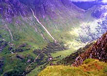
Upper Glen Nevis from the summit of Sgùrr a' Mhàim. The Allt Coire
Eoghainn can be seen cascading from Coire Eoghainn on Ben Nevis down to the glen.
576:
505:
492:
475:
462:
445:
432:
908:
869:
239:
569:
302:
Looking along the Devil’s Ridge from the lower slopes of Sgùrr a' Mhàim. The demoted Munro Sgor an
Iubhair is on the left hand side.
298:
893:
200:
105:
848:
736:
713:
376:
807:
332:
324:
160:
812:
371:
Sgùrr a' Mhàim is the first or last peak of the 'Ring of Steall', a ridge walk taking in the other Munros of
833:
792:
767:
858:
600:
77:
67:
746:
782:
708:
698:
751:
741:
644:
797:
787:
718:
561:
454:
344:
336:
89:
306:
913:
853:
501:
488:
471:
458:
441:
428:
888:
693:
484:
226:
219:
214:
688:
186:
98:
82:
525:
882:
802:
632:
363:
stones give it a light grey appearance which can be mistaken for a covering of snow.
654:
843:
828:
777:
728:
683:
678:
384:
372:
17:
627:
604:
614:
838:
352:
127:
114:
772:
673:
638:
412:
380:
360:
348:
596:
179:
175:
665:
546:"The Magic Of The Munros" Pages 61 (Gives details on name translation).
340:
193:
402:
which end abruptly in cliffs which fall steeply into the Nevis gorge.
399:
355:. With a height of 1099 metres (3605 feet), Sgùrr a' Mhàim is a
57:
592:
356:
305:
297:
94:
46:
Sgùrr a' Mhàim with its quartzite cap seen from the Devil’s Ridge
555:"Hamish‘s Mountain Walk" Page 164 (Gives quote on Devils Ridge).
565:
653:
390:
The Devil's Ridge has its own peak at the midpoint called
394:(990 metres high). At the southern end of the ridge is
359:
and the second-highest peak in the
Mamores. Its cap of
314:
821:
760:
727:
664:
620:
213:
199:
185:
171:
166:
156:
148:
143:
104:
88:
76:
66:
56:
51:
34:
415:, and also an aerial view down into Glen Nevis.
904:Mountains and hills of Highland (council area)
577:
8:
899:Mountains and hills of the Central Highlands
584:
570:
562:
237:
31:
870:List of Munros and Munro Tops in Scotland
451:The High Mountains of Britain and Ireland
481:The Munros, Scotland's Highest Mountains
517:
438:100 Best Routes on Scottish Mountains
323:
7:
25:
613:
40:
152:peak of the large rounded hill
1:
526:"walkhighlands Sgurr a'Mhaim"
339:') is a mountain of the
62:1,099 m (3,606 ft)
909:One-thousanders of Scotland
528:. walkhighlands.co.uk. 2013
335:for 'rocky peak of the
930:
347:. It is directly south of
271:1001 m (3284 ft)
72:316 m (1,037 ft)
867:
651:
611:
427:, Donald Bennett et al.,
325:[ˈs̪kuːrˠəˈvãːjm]
289:990 m (3248 ft)
39:
849:Stob a' Choire Mheadhoin
813:Mullach Coire an Iubhair
498:The Magic Of The Munros
351:, on the other side of
658:
500:, Irvine Butterfield,
468:Hamish’s Mountain Walk
425:The Munros (SMC Guide)
315:
311:
303:
242:of Sgùrr a' Mhàim
657:
309:
301:
894:Marilyns of Scotland
859:Stob Coire Sgriodain
752:Stob Coire an Laoigh
742:Stob Choire Claurigh
714:Stob Coire a' Chàirn
392:Stob Choire a' Mhàil
377:Stob Coire a' Chàirn
279:Stob Choire a’ Mhàil
27:Mountain in Scotland
747:Sgùrr Choinnich Mòr
719:Mullach nan Coirean
243:
149:English translation
124: /
18:Sgurr a' Mhaim
783:Beinn a' Chlachair
659:
455:Irvine Butterfield
345:Scottish Highlands
312:
304:
238:
128:56.7559°N 5.0038°W
52:Highest point
876:
875:
854:Stob Coire Easain
506:978-0-7153-2168-3
493:978-1-84204-082-9
476:978-1-898573-08-1
463:978-0-906371-30-5
446:978-0-7515-0300-5
433:978-0-907521-13-6
296:
295:
236:
235:
16:(Redirected from
921:
761:Alder/Ardverikie
617:
586:
579:
572:
563:
556:
553:
547:
544:
538:
537:
535:
533:
522:
470:, Hamish Brown,
440:, Ralph Storer,
396:Sgùrr an Iubhair
330:
327:
322:
321:Scottish Gaelic:
286:
268:
261:Sgùrr an Iubhair
244:
209:
189:
157:Language of name
139:
138:
136:
135:
134:
133:56.7559; -5.0038
129:
125:
122:
121:
120:
117:
44:
32:
21:
929:
928:
924:
923:
922:
920:
919:
918:
879:
878:
877:
872:
863:
817:
756:
723:
699:Sgùrr Eilde Mòr
694:Na Gruagaichean
660:
649:
618:
607:
590:
560:
559:
554:
550:
545:
541:
531:
529:
524:
523:
519:
485:Cameron McNeish
421:
408:
369:
333:Scottish Gaelic
320:
282:
264:
205:
187:
132:
130:
126:
123:
118:
115:
113:
111:
110:
47:
28:
23:
22:
15:
12:
11:
5:
927:
925:
917:
916:
911:
906:
901:
896:
891:
881:
880:
874:
873:
868:
865:
864:
862:
861:
856:
851:
846:
841:
836:
831:
825:
823:
819:
818:
816:
815:
810:
805:
800:
795:
790:
785:
780:
775:
770:
764:
762:
758:
757:
755:
754:
749:
744:
739:
733:
731:
725:
724:
722:
721:
716:
711:
706:
704:Sgùrr a' Mhàim
701:
696:
691:
686:
681:
676:
670:
668:
662:
661:
652:
650:
648:
647:
645:Càrn Mòr Dearg
642:
635:
630:
624:
622:
619:
612:
609:
608:
591:
589:
588:
581:
574:
566:
558:
557:
548:
539:
516:
515:
509:
508:
495:
478:
465:
448:
435:
420:
417:
407:
404:
368:
365:
317:Sgùrr a' Mhàim
294:
293:
290:
287:
280:
276:
275:
272:
269:
262:
258:
257:
254:
251:
248:
240:Listed summits
234:
233:
217:
211:
210:
203:
197:
196:
191:
183:
182:
173:
169:
168:
164:
163:
158:
154:
153:
150:
146:
145:
141:
140:
108:
102:
101:
92:
86:
85:
80:
74:
73:
70:
64:
63:
60:
54:
53:
49:
48:
45:
37:
36:
35:Sgùrr a' Mhàim
26:
24:
14:
13:
10:
9:
6:
4:
3:
2:
926:
915:
912:
910:
907:
905:
902:
900:
897:
895:
892:
890:
887:
886:
884:
871:
866:
860:
857:
855:
852:
850:
847:
845:
842:
840:
837:
835:
832:
830:
827:
826:
824:
820:
814:
811:
809:
806:
804:
801:
799:
798:Creag Pitridh
796:
794:
791:
789:
788:Beinn Eibhinn
786:
784:
781:
779:
776:
774:
771:
769:
766:
765:
763:
759:
753:
750:
748:
745:
743:
740:
738:
735:
734:
732:
730:
726:
720:
717:
715:
712:
710:
707:
705:
702:
700:
697:
695:
692:
690:
687:
685:
682:
680:
677:
675:
672:
671:
669:
667:
663:
656:
646:
643:
641:
640:
636:
634:
631:
629:
626:
625:
623:
616:
610:
606:
602:
598:
594:
587:
582:
580:
575:
573:
568:
567:
564:
552:
549:
543:
540:
527:
521:
518:
514:
513:
507:
503:
499:
496:
494:
490:
486:
482:
479:
477:
473:
469:
466:
464:
460:
456:
452:
449:
447:
443:
439:
436:
434:
430:
426:
423:
422:
418:
416:
414:
405:
403:
401:
397:
393:
388:
386:
382:
378:
374:
366:
364:
362:
358:
354:
350:
346:
343:range in the
342:
338:
334:
329:
326:
318:
308:
300:
291:
288:
285:
281:
278:
277:
273:
270:
267:
263:
260:
259:
255:
252:
249:
246:
245:
241:
231:
228:
224:
221:
218:
216:
212:
208:
204:
202:
198:
195:
192:
190:
184:
181:
177:
174:
170:
165:
162:
159:
155:
151:
147:
142:
137:
109:
107:
103:
100:
96:
93:
91:
87:
84:
81:
79:
75:
71:
69:
65:
61:
59:
55:
50:
43:
38:
33:
30:
19:
844:Sgor Gaibhre
829:Beinn na Lap
822:Ossian/Treig
778:Beinn Bheòil
729:Grey Corries
703:
684:Binnein Beag
679:An Gearanach
637:
601:Fort William
551:
542:
530:. Retrieved
520:
511:
510:
497:
480:
467:
450:
437:
424:
409:
395:
391:
389:
385:Hamish Brown
373:An Gearanach
370:
337:rounded hill
316:
313:
229:
222:
188:Parent range
29:
768:Aonach Beag
689:Binnein Mòr
628:Aonach Beag
621:Nevis range
605:Loch Ericht
532:25 November
131: /
106:Coordinates
83:Binnein Mòr
78:Parent peak
883:Categories
839:Chno Dearg
834:Càrn Dearg
808:Geal Charn
803:Geal-Chàrn
793:Càrn Dearg
633:Aonach Mòr
419:References
353:Glen Nevis
292:Munro Top
274:Munro Top
223:Landranger
116:56°45′21″N
68:Prominence
773:Ben Alder
674:Am Bodach
639:Ben Nevis
512:Footnotes
413:Ben Nevis
381:Am Bodach
367:Landscape
361:quartzite
349:Ben Nevis
167:Geography
119:5°00′14″W
58:Elevation
914:Lochaber
737:Stob Bàn
709:Stob Bàn
597:Scotland
406:Climbing
266:NN165655
250:Grid ref
230:Explorer
215:Topo map
207:NN164667
180:Scotland
176:Lochaber
172:Location
666:Mamores
400:corries
341:Mamores
284:N163659
256:Status
201:OS grid
194:Mamores
99:Marilyn
90:Listing
889:Munros
593:Munros
504:
491:
474:
461:
444:
431:
253:Height
161:Gaelic
144:Naming
357:Munro
95:Munro
534:2013
502:ISBN
489:ISBN
472:ISBN
459:ISBN
442:ISBN
429:ISBN
379:and
247:Name
225:41,
603:to
595:of
232:392
885::
599::
487:,
483:,
457:,
453:,
375:,
227:OS
220:OS
178:,
97:,
585:e
578:t
571:v
536:.
331:(
328:)
319:(
20:)
Text is available under the Creative Commons Attribution-ShareAlike License. Additional terms may apply.