19:
27:
64:
in late
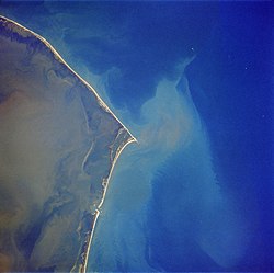
September 2017. At its greatest extent, the crescent-shaped island measured around one mile long and more than 500 ft (150 m) wide. It was nicknamed Shelly Island by locals because of the vast quantities of shells that were found on the shore. By early 2018, the island had
99:
As of
September 18, 2017, Shelly Island was connected to land at low tide, with water continuing to separate the island from the mainland at high tide. Over the next few weeks, the channel between the island and the mainland began to deepen again.
96:. In September 2017, businessman Ken Barlow filed a quitclaim deed against the island, seeking ownership of the land. At that time, experts cautioned that the island would likely not last a full year as a separate landform.
81:. Small landmasses frequently appear and vanish in this area, but Shelly Island was notable for its size and the speed with which it formed. One explanation for the island's formation was a lack of strong
223:
107:, North Carolina estimated that the island had been reduced by 70%, with the portion closest to the mainland reattaching, and a small oval of land remaining unattached offshore.
394:
404:
389:
399:
114:
taken on
February 16, 2018 revealed that the island had completely disappeared and that what remained of the island had merged with Cape Point, North Carolina.
350:
276:
134:
Register of Deeds office on August 7, 2017. Barlow reasserted his claim in early 2018 despite the apparent disappearance of the island.
85:
storms the previous winter, along with more than typical southwesterly winds, which led to the buildup of additional sand in the area.
409:
92:. If it had grown enough to merge into Hatteras Island, it would potentially have come under federal jurisdiction and become part of
240:
93:
131:
89:
301:
199:
78:
123:
414:
57:
77:, with water at depth of no more than 5 ft (1.5 m). The surrounding area is referred to as the
172:
419:
338:
326:
154:
30:
1989 photo of Cape
Hatteras, with Cape Point at center. Shelly Island formed just off the tip of
18:
258:
104:
74:
61:
53:
31:
127:
49:
383:
82:
26:
327:
With
Hurricane Irma looming, thinking businessman files claim on NC's new island
45:
155:"So who owns that new island off North Carolina? It's likely not who you think"
365:
352:
173:"How Are Islands Formed? New Mysterious Land Mass Appears off North Carolina"
111:
88:
As long as the island remained detached, it fell under the jurisdiction of
177:
41:
126:, alleged that he was the rightful owner of the island by way of a
17:
277:"No more Shelly Island? Outer Banks tract now connected to land"
224:"New Island Appears Off Coast of North Carolina in Outer Banks"
200:"Shelly Island: The new beach off North Carolina's Outer Banks"
40:
was a sandy island which began forming around April 2017, as a
259:"NC's mysterious new island does something mysterious again"
241:
While a new island grew, southern
Hatteras was shrinking
60:, the island was greatly reduced by the passage of
302:"Shelly Island is no longer an island, NASA says"
103:In late September 2017, after the passage of
8:
73:The island sat a few hundred feet away from
243:. The Outer Banks Voice. November 1, 2017.
122:Ken Barlow, a businessman and resident of
253:
251:
249:
395:Uninhabited islands of the United States
218:
216:
25:
149:
147:
143:
405:April 2017 events in the United States
390:Islands of Dare County, North Carolina
400:2017 establishments in North Carolina
7:
14:
171:Janice Williams (June 30, 2017).
22:NASA Photos of Shelly Island, NC
94:Cape Hatteras National Seashore
275:EndPlay (September 18, 2017).
1:
339:Can you own a sunken island?
366:35.21348833°N 75.52793472°W
90:Dare County, North Carolina
436:
410:Islands of North Carolina
371:35.21348833; -75.52793472
341:Retrieved March 15, 2018.
329:Retrieved March 15, 2018.
79:Graveyard of the Atlantic
52:. Located off the tip of
124:Mechanicsville, Virginia
58:Buxton, North Carolina
34:
23:
29:
21:
362: /
228:National Geographic
130:he executed in the
265:. October 1, 2017.
263:Charlotte Observer
239:Kozak, Catherine.
159:Charlotte Observer
35:
24:
110:Photographs from
427:
377:
376:
374:
373:
372:
367:
363:
360:
359:
358:
355:
342:
336:
330:
324:
318:
317:
315:
313:
298:
292:
291:
289:
287:
272:
266:
255:
244:
237:
231:
230:. June 27, 2017.
220:
211:
210:
208:
206:
196:
190:
189:
187:
185:
168:
162:
151:
435:
434:
430:
429:
428:
426:
425:
424:
380:
379:
370:
368:
364:
361:
356:
353:
351:
349:
348:
346:
345:
337:
333:
325:
321:
311:
309:
308:. March 9, 2018
300:
299:
295:
285:
283:
274:
273:
269:
256:
247:
238:
234:
221:
214:
204:
202:
198:
197:
193:
183:
181:
170:
169:
165:
161:. July 7, 2017.
152:
145:
140:
120:
118:Ownership claim
105:Hurricane Maria
75:Hatteras Island
71:
62:Hurricane Maria
12:
11:
5:
433:
431:
423:
422:
417:
412:
407:
402:
397:
392:
382:
381:
357:75°31′40.565″W
354:35°12′48.558″N
344:
343:
331:
319:
293:
267:
245:
232:
222:Welch, Craig.
212:
191:
163:
142:
141:
139:
136:
128:quitclaim deed
119:
116:
70:
67:
50:North Carolina
13:
10:
9:
6:
4:
3:
2:
432:
421:
418:
416:
415:Sandy islands
413:
411:
408:
406:
403:
401:
398:
396:
393:
391:
388:
387:
385:
378:
375:
340:
335:
332:
328:
323:
320:
307:
303:
297:
294:
286:September 18,
282:
278:
271:
268:
264:
260:
257:Price, Mark.
254:
252:
250:
246:
242:
236:
233:
229:
225:
219:
217:
213:
205:September 18,
201:
195:
192:
180:
179:
174:
167:
164:
160:
156:
153:Price, Mark.
150:
148:
144:
137:
135:
133:
129:
125:
117:
115:
113:
108:
106:
101:
97:
95:
91:
86:
84:
80:
76:
68:
66:
65:disappeared.
63:
59:
55:
51:
47:
43:
39:
38:Shelly Island
33:
28:
20:
16:
347:
334:
322:
310:. Retrieved
305:
296:
284:. Retrieved
280:
270:
262:
235:
227:
203:. Retrieved
194:
182:. Retrieved
176:
166:
158:
121:
109:
102:
98:
87:
72:
37:
36:
15:
420:Outer Banks
369: /
132:Dare County
46:Outer Banks
384:Categories
138:References
83:nor'easter
54:Cape Point
32:Cape Point
312:March 14,
112:Landsat 8
69:Geography
178:Newsweek
42:sandbank
184:July 2,
44:in the
314:2018
306:WWAY
288:2017
281:WSOC
207:2018
186:2017
56:in
48:of
386::
304:.
279:.
261:,
248:^
226:,
215:^
175:.
157:,
146:^
316:.
290:.
209:.
188:.
Text is available under the Creative Commons Attribution-ShareAlike License. Additional terms may apply.