88:
60:
41:
1136:
1083:
374:
778:
95:
67:
537:
365:
87:
59:
1173:
1057:
1017:
937:
847:
897:
574:
952:
1212:
997:
852:
144:
1202:
922:
652:
541:
692:
1120:
902:
987:
957:
927:
877:
817:
667:
1166:
907:
822:
1027:
932:
867:
837:
1207:
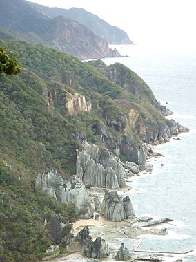
1047:
892:
712:
567:
917:
882:
1022:
872:
1242:
992:
977:
947:
942:
426:
1159:
972:
797:
1052:
1007:
1002:
842:
408:
962:
1197:
857:
747:
677:
560:
1237:
1222:
802:
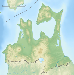
682:
657:
622:
583:
387:
223:
1042:
1037:
912:
30:
737:
727:
627:
353:
Like all Quasi-National Parks in Japan, Shimokita Hantō Quasi-National Park is managed by the local prefectural government.
1113:
862:
832:
812:
672:
642:
607:
982:
887:
792:
767:
602:
1032:
752:
1062:
1012:
827:
807:
722:
617:
687:
637:
612:
316:
1192:
1106:
732:
632:
40:
967:
762:
742:
702:
662:
331:
1217:
697:
339:
757:
647:
455:
295:
1227:
717:
1142:
This article about a national/quasi-national park or protected area in Japan, or related topic is a
1135:
227:
547:
505:
597:
1082:
707:
511:
404:
373:
231:
195:
434:
308:
235:
480:
1232:
777:
1143:
1090:
347:
1186:
335:
312:
132:
45:
291:
269:
259:
343:
285:
279:
263:
159:
146:
462:. United Nations Environment Programme, World Conservation Monitoring Center
239:
118:
552:
536:
433:. Ministry of the Environment of the Government of Japan. Archived from
250:. The park, consists of several discontinuous locations, which include:
300:
255:
364:
327:. The area was designated a quasi-national park on July 22, 1968.
320:
307:
The park also encompasses a portion of the natural habitat of the
273:
246:. It is rated a protected landscape (category V) according to the
243:
122:
247:
556:
324:
510:[Shimokita Hantō Quasi-National Park] (in Japanese).
487:. Ministry of the Environment Government of Japan. 1994-03-31
94:
66:
1147:
1094:
485:
Official Home Page of the
Ministry of the Environment
427:"National Park systems: Definition of National Parks"
785:
590:
191:
183:
175:
138:
128:
114:
18:
215:
209:
1167:
1114:
1089:This Aomori Prefecture location article is a
568:
8:
311:. The mountainous interior is forested with
294:, the northeasternmost point Honshū and the
74:Shimokita Hanto Quasi-National Park in Japan
548:Maps of Shimokita Hantō Quasi-National Park
102:Shimokita Hantō Quasi-National Park (Japan)
1174:
1160:
1121:
1107:
575:
561:
553:
15:
399:Southerland, Mary and Britton, Dorothy.
282:on the west coast of Shimokita Peninsula
415:
360:
303:, an island off the coast of Wakinosawa
179:18,728 hectares (72.31 sq mi)
1213:Parks and gardens in Aomori Prefecture
421:
419:
7:
1132:
1130:
1079:
1077:
113:
1203:Protected areas established in 1968
319:, and coastal areas have stands of
205:Shimokita Hantō Quasi-National Park
19:Shimokita Hantō Quasi-National Park
542:Shimokitahanto Quasi-National Park
288:, the northernmost point of Honshū
14:
460:World Database on Protected Areas
403:. Kodansha International (1995).
330:The borders of the park span the
1134:
1081:
776:
535:
372:
363:
93:
86:
65:
58:
39:
33:V (protected landscape/seascape)
388:List of national parks of Japan
278:the coastal rock formations of
182:
127:
481:"List of Quasi-national Parks"
1:
77:Show map of Aomori Prefecture
1208:1968 establishments in Japan
1146:. You can help Knowledge by
1093:. You can help Knowledge by
953:Niseko-Shakotan-Otaru Kaigan
653:Hidakasanmyaku-Erimo-Tokachi
217:Shimokita-hantō Kokutei Kōen
1018:Tango-Amanohashidate-Ōeyama
998:Shokanbetsu-Teuri-Yagishiri
848:Hyōnosen-Ushiroyama-Nagisan
401:The National Parks of Japan
216:
1259:
1243:Japan protected area stubs
1129:
1076:
198:, prefectural governments
1058:Yatsugatake-Chūshin Kōgen
774:
210:
52:
38:
28:
23:
938:Myōgi-Arafune-Saku Kōgen
506:
266:and surrounding forests.
1198:National parks of Japan
923:Minami Sanriku Kinkasan
713:Rishiri-Rebun-Sarobetsu
584:National parks of Japan
431:National Parks of Japan
264:Osorezan Mountain Range
1238:Aomori geography stubs
693:Myōkō-Togakushi Renzan
160:41.52583°N 140.92361°E
296:Sarugamori Sand Dunes
988:Sado-Yahiko-Yoneyama
958:Nishi-Chūgoku Sanchi
818:Echigo Sanzan-Tadami
786:Quasi-National Parks
544:at Wikimedia Commons
1223:Higashidōri, Aomori
908:Meiji no Mori Takao
853:Ibi-Sekigahara-Yōrō
823:Echizen-Kaga Kaigan
228:Shimokita Peninsula
224:quasi-national park
192:Governing body
165:41.52583; 140.92361
156: /
933:Muroto-Anan Kaigan
903:Meiji no Mori Minō
898:Kyūshū Chūō Sanchi
838:Hiba-Dōgo-Taishaku
748:Towada-Hachimantai
678:Kirishima-Kinkowan
1155:
1154:
1102:
1101:
1071:
1070:
1048:Yaba-Hita-Hikosan
928:Murō-Akame-Aoyama
893:Kyoto Tamba Kōgen
878:Kongō-Ikoma-Kisen
683:Kushiro Shitsugen
658:Iriomote-Ishigaki
623:Chichibu-Tama-Kai
540:Media related to
512:Aomori Prefecture
456:"Shimokita Hanto"
232:Aomori Prefecture
202:
201:
129:Nearest city
105:Show map of Japan
1250:
1176:
1169:
1162:
1138:
1131:
1123:
1116:
1109:
1085:
1078:
1028:Tenryū-Okumikawa
780:
668:Jōshinetsu Kōgen
577:
570:
563:
554:
539:
523:
522:
520:
518:
502:
496:
495:
493:
492:
477:
471:
470:
468:
467:
452:
446:
445:
443:
442:
423:
376:
367:
309:Japanese macaque
238:of far northern
221:
219:
213:
212:
171:
170:
168:
167:
166:
161:
157:
154:
153:
152:
149:
106:
97:
96:
90:
78:
69:
68:
62:
43:
16:
1258:
1257:
1253:
1252:
1251:
1249:
1248:
1247:
1193:IUCN Category V
1183:
1182:
1181:
1180:
1128:
1127:
1074:
1072:
1067:
993:Shimokita Hantō
978:Okinawa Senseki
943:Nichinan Kaigan
781:
772:
643:Fuji-Hakone-Izu
608:Ashizuri-Uwakai
586:
581:
532:
527:
526:
516:
514:
508:
504:
503:
499:
490:
488:
479:
478:
474:
465:
463:
454:
453:
449:
440:
438:
425:
424:
417:
396:
384:
377:
368:
359:
313:Siebold's beech
207:
164:
162:
158:
155:
150:
147:
145:
143:
142:
110:
109:
108:
107:
104:
103:
100:
99:
98:
81:
80:
79:
76:
75:
72:
71:
70:
48:
34:
12:
11:
5:
1256:
1254:
1246:
1245:
1240:
1235:
1230:
1225:
1220:
1215:
1210:
1205:
1200:
1195:
1185:
1184:
1179:
1178:
1171:
1164:
1156:
1153:
1152:
1139:
1126:
1125:
1118:
1111:
1103:
1100:
1099:
1086:
1069:
1068:
1066:
1065:
1060:
1055:
1050:
1045:
1040:
1035:
1030:
1025:
1020:
1015:
1010:
1005:
1000:
995:
990:
985:
980:
975:
973:Okinawa Kaigan
970:
965:
960:
955:
950:
945:
940:
935:
930:
925:
920:
915:
910:
905:
900:
895:
890:
885:
880:
875:
870:
865:
860:
855:
850:
845:
840:
835:
830:
825:
820:
815:
810:
805:
800:
795:
789:
787:
783:
782:
775:
773:
771:
770:
768:Yoshino-Kumano
765:
760:
755:
750:
745:
740:
735:
730:
725:
720:
715:
710:
705:
700:
695:
690:
685:
680:
675:
670:
665:
660:
655:
650:
645:
640:
635:
630:
625:
620:
615:
610:
605:
600:
594:
592:
591:National Parks
588:
587:
582:
580:
579:
572:
565:
557:
551:
550:
545:
531:
530:External links
528:
525:
524:
497:
472:
447:
414:
413:
412:
411:
395:
392:
391:
390:
383:
380:
379:
378:
371:
369:
362:
358:
355:
332:municipalities
317:Nootka cypress
305:
304:
298:
289:
283:
276:
267:
256:volcanic peaks
200:
199:
193:
189:
188:
185:
181:
180:
177:
173:
172:
140:
136:
135:
130:
126:
125:
116:
112:
111:
101:
92:
91:
85:
84:
83:
82:
73:
64:
63:
57:
56:
55:
54:
53:
50:
49:
44:
36:
35:
29:
26:
25:
21:
20:
13:
10:
9:
6:
4:
3:
2:
1255:
1244:
1241:
1239:
1236:
1234:
1231:
1229:
1226:
1224:
1221:
1219:
1218:Mutsu, Aomori
1216:
1214:
1211:
1209:
1206:
1204:
1201:
1199:
1196:
1194:
1191:
1190:
1188:
1177:
1172:
1170:
1165:
1163:
1158:
1157:
1151:
1149:
1145:
1140:
1137:
1133:
1124:
1119:
1117:
1112:
1110:
1105:
1104:
1098:
1096:
1092:
1087:
1084:
1080:
1075:
1064:
1061:
1059:
1056:
1054:
1053:Yamato-Aogaki
1051:
1049:
1046:
1044:
1041:
1039:
1036:
1034:
1031:
1029:
1026:
1024:
1023:Tanzawa-Ōyama
1021:
1019:
1016:
1014:
1011:
1009:
1008:Suigō-Tsukuba
1006:
1004:
1003:Sobo Katamuki
1001:
999:
996:
994:
991:
989:
986:
984:
981:
979:
976:
974:
971:
969:
966:
964:
961:
959:
956:
954:
951:
949:
946:
944:
941:
939:
936:
934:
931:
929:
926:
924:
921:
919:
916:
914:
911:
909:
906:
904:
901:
899:
896:
894:
891:
889:
886:
884:
881:
879:
876:
874:
871:
869:
866:
864:
861:
859:
856:
854:
851:
849:
846:
844:
843:Hida-Kisogawa
841:
839:
836:
834:
831:
829:
826:
824:
821:
819:
816:
814:
811:
809:
806:
804:
801:
799:
796:
794:
791:
790:
788:
784:
779:
769:
766:
764:
761:
759:
756:
754:
753:Unzen-Amakusa
751:
749:
746:
744:
741:
739:
738:Shikotsu-Tōya
736:
734:
731:
729:
728:Sanriku Fukkō
726:
724:
721:
719:
716:
714:
711:
709:
706:
704:
701:
699:
696:
694:
691:
689:
686:
684:
681:
679:
676:
674:
671:
669:
666:
664:
661:
659:
656:
654:
651:
649:
646:
644:
641:
639:
636:
634:
631:
629:
628:Chūbu-Sangaku
626:
624:
621:
619:
616:
614:
611:
609:
606:
604:
601:
599:
596:
595:
593:
589:
585:
578:
573:
571:
566:
564:
559:
558:
555:
549:
546:
543:
538:
534:
533:
529:
513:
509:
501:
498:
486:
482:
476:
473:
461:
457:
451:
448:
437:on 2011-03-23
436:
432:
428:
422:
420:
416:
410:
409:4-7700-1971-8
406:
402:
398:
397:
393:
389:
386:
385:
381:
375:
370:
366:
361:
356:
354:
351:
349:
345:
341:
337:
333:
328:
326:
322:
318:
314:
310:
302:
299:
297:
293:
290:
287:
284:
281:
277:
275:
271:
268:
265:
261:
260:caldera lakes
257:
253:
252:
251:
249:
245:
241:
237:
236:Tōhoku region
233:
229:
225:
218:
206:
197:
194:
190:
187:July 22, 1968
186:
178:
174:
169:
141:
137:
134:
131:
124:
120:
117:
89:
61:
51:
47:
46:Hotoke-ga-ura
42:
37:
32:
31:IUCN category
27:
22:
17:
1148:expanding it
1141:
1095:expanding it
1088:
1073:
948:Nippō Kaigan
858:Iki-Tsushima
723:Sanin Kaigan
673:Kerama Shotō
618:Bandai-Asahi
515:. Retrieved
500:
489:. Retrieved
484:
475:
464:. Retrieved
459:
450:
439:. Retrieved
435:the original
430:
400:
352:
329:
306:
292:Cape Shiriya
270:Yagen Valley
204:
203:
1228:Sai, Aomori
918:Minami Bōsō
883:Kōya-Ryūjin
868:Kita Nagato
803:Akiyoshidai
798:Aichi Kōgen
688:Minami Alps
638:Daisetsuzan
603:Amami Guntō
340:Higashidōri
280:Hotokegaura
274:hot springs
272:, with its
184:Established
163: /
151:140°55′25″E
139:Coordinates
1187:Categories
1043:Wakasa Wan
1038:Tsurugisan
963:Noto Hantō
913:Mikawa Wan
873:Kitakyūshū
733:Setonaikai
633:Daisen-Oki
491:2009-10-05
466:2009-10-05
441:2008-08-29
394:References
148:41°31′33″N
863:Ishizuchi
833:Hayachine
763:Yakushima
743:Shiretoko
703:Ogasawara
663:Ise-Shima
517:23 August
888:Kurikoma
793:Abashiri
613:Aso-Kujū
507:下北半島国定公園
382:See also
286:Cape Ōma
211:下北半島国定公園
115:Location
24:下北半島国定公園
1033:Tsugaru
758:Yambaru
648:Hakusan
357:Gallery
301:Taijima
262:of the
234:in the
226:in the
1013:Suzuka
828:Genkai
813:Chōkai
808:Biwako
718:Saikai
407:
346:, and
240:Honshū
196:Aomori
119:Honshū
983:Ōnuma
698:Nikkō
336:Mutsu
321:tilia
244:Japan
222:is a
133:Mutsu
123:Japan
1144:stub
1091:stub
598:Akan
519:2012
405:ISBN
323:and
315:and
258:and
254:the
248:IUCN
176:Area
1233:Ōma
1063:Zaō
968:Oga
708:Oze
348:Ōma
344:Sai
334:of
325:oak
242:in
230:of
1189::
483:.
458:.
429:.
418:^
350:.
342:,
338:,
214:,
121:,
1175:e
1168:t
1161:v
1150:.
1122:e
1115:t
1108:v
1097:.
576:e
569:t
562:v
521:.
494:.
469:.
444:.
220:)
208:(
Text is available under the Creative Commons Attribution-ShareAlike License. Additional terms may apply.