1867:
1791:
1756:
1721:
1686:
1651:
1616:
1581:
1546:
1511:
1483:
1448:
1413:
1378:
1343:
1308:
1273:
1238:
1210:
1175:
1140:
1105:
1070:
1035:
1007:
886:
143:
39:
1829:
1803:
2881:
1894:
837:
1887:
1880:
129:
117:
2866:
1903:
245:
901:
2871:
2827:
2481:
2471:
2294:
2759:
2203:
2284:
2216:
1790:
1755:
1720:
1685:
1650:
1615:
1545:
1510:
1482:
1447:
1412:
1377:
1342:
1307:
1272:
1139:
1104:
1069:
1034:
1006:
843:
2511:
1580:
1174:
885:
2772:
122:
1237:
1209:
1768:
1733:
1698:
1663:
1628:
1593:
1558:
1523:
1495:
1460:
1425:
1390:
1355:
1320:
1285:
1250:
1222:
1187:
1152:
1117:
1082:
1047:
1019:
984:
863:
2163:
2463:
2093:
1499:
1023:
260:. The Shire covers an area of 46,664 square kilometres (18,017 sq mi), and its seat of government is the town of
2536:
2271:
751:
707:
329:
167:
2304:
729:
465:
443:
261:
105:
98:
2734:
487:
377:
355:
2876:
553:
795:
509:
421:
685:
663:
641:
575:
2767:
2332:
2088:
1911:
773:
531:
399:
285:
2140:
619:
2699:
2397:
2183:
597:
306:
The Shire is divided into 4 wards, most of which have one councillor. The Shire
President is directly elected.
2644:
2317:
2130:
205:
1226:
2382:
2057:
1772:
1737:
1702:
1667:
1632:
1597:
1562:
1527:
1464:
1429:
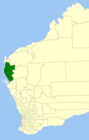
1394:
1359:
1324:
1289:
1254:
1191:
1156:
1121:
1086:
1051:
988:
867:
804:
782:
760:
738:
716:
694:
672:
650:
628:
606:
584:
562:
540:
518:
496:
474:
452:
430:
408:
386:
364:
328:
The towns, suburbs and localities of the Shire of
Carnarvon with population and size figures based on the
63:
2609:
2443:
2357:
2261:
2188:
2067:
2739:
2714:
2476:
2453:
2367:
2342:
2289:
2256:
2236:
2231:
963:
2679:
2649:
2629:
2604:
2594:
2584:
2579:
2559:
2554:
2405:
2148:
2062:
1996:
332:
2709:
2654:
2574:
2569:
2438:
2377:
2372:
2362:
2241:
2221:
2158:
2125:
2083:
2037:
1991:
224:
219:
188:
134:
2729:
2724:
2719:
2694:
2674:
2669:
2659:
2634:
2614:
2564:
2549:
2544:
2521:
2506:
2491:
2347:
2312:
2168:
2052:
2047:
2042:
1966:
1961:
1951:
1931:
1872:
281:
253:
44:
29:
842:
As of 2024, 111 places are heritage-listed in the Shire of
Carnarvon, of which 13 are on the
2744:
2689:
2664:
2589:
2448:
2420:
2410:
2251:
2226:
2178:
2173:
2120:
2021:
2001:
1981:
1976:
1956:
1946:
1926:
183:
2684:
2619:
2599:
2526:
2516:
2501:
2486:
2415:
2387:
2352:
2322:
2279:
2193:
2153:
2016:
2006:
1971:
1941:
1936:
1866:
280:
The Shire of
Carnarvon was established on 12 February 1965 with the amalgamation of the
142:
2704:
2639:
2624:
2496:
2337:
2211:
291:
2860:
2749:
2246:
1986:
824:
2327:
2011:
295:
213:
196:
177:
926:
38:
2842:
2829:
2814:
Western
Australian law applies to the Indian Ocean Territories under the
2107:
934:
256:, located about 900 kilometres (560 mi) north of the state capital,
249:
110:
2430:
269:
265:
264:. The major industries in the area are wool, agriculture (especially
838:
List of State
Register of Heritage Places in the Shire of Carnarvon
2882:
Local government areas of the
Gascoyne region of Western Australia
257:
1860:
154:
1876:
298:
and Koks Island were included in the shire on 3 December 1982.
955:
827:, Shire of Carnarvon councillor 1975–1988; later a state MP
1830:"Shire of Carnarvon State Register of Heritage Places"
907:. Western Australian Electoral Distribution Commission
2758:
2535:
2462:
2429:
2396:
2303:
2270:
2202:
2139:
2106:
2076:
2030:
1919:
1910:
149:
128:
116:
104:
94:
86:
78:
70:
55:
23:
162:
1888:
60:
8:
1904:Local government areas of Western Australia
902:"Municipality Boundary Amendments Register"
801:
779:
757:
735:
713:
691:
669:
647:
625:
603:
581:
559:
537:
515:
493:
471:
449:
427:
405:
383:
361:
82:46,663.5 km (18,016.9 sq mi)
1916:
1895:
1881:
1873:
1865:
1789:
1754:
1719:
1684:
1649:
1614:
1579:
1544:
1509:
1481:
1446:
1411:
1376:
1341:
1306:
1271:
1236:
1208:
1173:
1138:
1103:
1068:
1033:
1005:
884:
337:
141:
37:
20:
18:Local government area in Western Australia
1703:"South Plantations (suburb and locality)"
1633:"North Plantations (suburb and locality)"
810:3,603.5 km (1,391.3 sq mi)
678:9,031.3 km (3,487.0 sq mi)
634:5,946.8 km (2,296.1 sq mi)
612:9,214.8 km (3,557.9 sq mi)
568:4,119.9 km (1,590.7 sq mi)
546:7,548.7 km (2,914.6 sq mi)
1836:. Heritage Council of Western Australia
1810:. Heritage Council of Western Australia
1668:"South Carnarvon (suburb and locality)"
855:
1395:"Kingsford (WA) (suburb and locality)"
1255:"East Carnarvon (suburb and locality)"
1052:"Bernier Island (suburb and locality)"
1024:"Bernier Island (suburb and locality)"
989:"Babbage Island (suburb and locality)"
896:
894:
2802:This LGA holds town status under the
2790:This LGA holds city status under the
1360:"Kennedy Range (suburb and locality)"
788:777.4 km (300.2 sq mi)
210:
193:
174:
164:
7:
2867:Populated places established in 1965
1804:"Shire of Carnarvon Heritage Places"
1773:"Yandoo Creek (suburb and locality)"
1465:"Macleod (WA) (suburb and locality)"
1290:"Greys Plain (suburb and locality)"
1122:"Brown Range (suburb and locality)"
868:"Carnarvon (Local Government Area)"
722:28.7 km (11.1 sq mi)
392:43.8 km (16.9 sq mi)
1598:"Morgantown (suburb and locality)"
1528:"Massey Bay (suburb and locality)"
1500:"Massey Bay (suburb and locality)"
700:2.3 km (0.89 sq mi)
480:2.2 km (0.85 sq mi)
436:11.3 km (4.4 sq mi)
14:
1777:Australian Census 2021 QuickStats
1742:Australian Census 2021 QuickStats
1707:Australian Census 2021 QuickStats
1672:Australian Census 2021 QuickStats
1637:Australian Census 2021 QuickStats
1602:Australian Census 2021 QuickStats
1567:Australian Census 2021 QuickStats
1532:Australian Census 2016 QuickStats
1469:Australian Census 2021 QuickStats
1434:Australian Census 2021 QuickStats
1399:Australian Census 2021 QuickStats
1364:Australian Census 2021 QuickStats
1329:Australian Census 2021 QuickStats
1294:Australian Census 2021 QuickStats
1259:Australian Census 2021 QuickStats
1227:"Coral Bay (suburb and locality)"
1196:Australian Census 2021 QuickStats
1192:"Coral Bay (suburb and locality)"
1161:Australian Census 2021 QuickStats
1157:"Carnarvon (suburb and locality)"
1126:Australian Census 2021 QuickStats
1091:Australian Census 2021 QuickStats
1056:Australian Census 2016 QuickStats
993:Australian Census 2021 QuickStats
872:Australian Census 2021 QuickStats
844:State Register of Heritage Places
766:9.1 km (3.5 sq mi)
590:3.4 km (1.3 sq mi)
524:7.3 km (2.8 sq mi)
502:4.3 km (1.7 sq mi)
458:4.9 km (1.9 sq mi)
370:8.9 km (3.4 sq mi)
2872:1965 establishments in Australia
1738:"Wooramel (suburb and locality)"
1325:"Inggarda (suburb and locality)"
1087:"Brockman (suburb and locality)"
414:1 km (0.39 sq mi)
2816:Territories Law Reform Act 1992
1834:inherit.stateheritage.wa.gov.au
1808:inherit.stateheritage.wa.gov.au
1769:Australian Bureau of Statistics
1734:Australian Bureau of Statistics
1699:Australian Bureau of Statistics
1664:Australian Bureau of Statistics
1629:Australian Bureau of Statistics
1594:Australian Bureau of Statistics
1563:"Minilya (suburb and locality)"
1559:Australian Bureau of Statistics
1524:Australian Bureau of Statistics
1496:Australian Bureau of Statistics
1461:Australian Bureau of Statistics
1426:Australian Bureau of Statistics
1391:Australian Bureau of Statistics
1356:Australian Bureau of Statistics
1321:Australian Bureau of Statistics
1286:Australian Bureau of Statistics
1251:Australian Bureau of Statistics
1223:Australian Bureau of Statistics
1188:Australian Bureau of Statistics
1153:Australian Bureau of Statistics
1118:Australian Bureau of Statistics
1083:Australian Bureau of Statistics
1048:Australian Bureau of Statistics
1020:Australian Bureau of Statistics
985:Australian Bureau of Statistics
864:Australian Bureau of Statistics
744:3 km (1.2 sq mi)
656:6 km (2.3 sq mi)
272:) and, more recently, tourism.
1430:"Lyndon (suburb and locality)"
1:
2797:
2785:
324:Towns, suburbs and localities
2809:
2898:
835:
170:around Shire of Carnarvon:
2804:Local Government Act 1995
2792:Local Government Act 1995
2781:
310:Town Ward (6 councillors)
286:Shire of Gascoyne-Minilya
230:
165:
161:
140:
51:
36:
2760:Indian Ocean Territories
2773:Cocos (Keeling) Islands
2482:Bridgetown–Greenbushes
2472:Augusta–Margaret River
2295:Wyndham–East Kimberley
1504:Australian Census 2016
1231:Australian Census 2021
1028:Australian Census 2016
832:Heritage-listed places
319:Gascoyne/Minilya South
316:Gascoyne/Minilya North
2094:Serpentine-Jarrahdale
246:local government area
2285:Derby–West Kimberley
2217:Broomehill–Tambellup
2141:Goldfields–Esperance
964:Geoscience Australia
284:and the surrounding
2839: /
2512:Donnybrook–Balingup
931:maps.slip.wa.gov.au
819:Notable councillors
130:Federal division(s)
118:State electorate(s)
2877:Shire of Carnarvon
2843:24.884°S 113.661°E
2164:Kalgoorlie–Boulder
960:nationalmap.gov.au
242:Shire of Carnarvon
202:Shire of Carnarvon
155:Shire of Carnarvon
25:Shire of Carnarvon
2822:
2821:
2333:Greater Geraldton
2102:
2101:
816:
815:
752:South Plantations
708:North Plantations
333:Australian census
282:Town of Carnarvon
254:Western Australia
238:
237:
234:
233:
45:Western Australia
30:Western Australia
2889:
2854:
2853:
2851:
2850:
2849:
2848:-24.884; 113.661
2844:
2840:
2837:
2836:
2835:
2832:
2813:
2801:
2789:
2768:Christmas Island
2089:Peppermint Grove
1917:
1897:
1890:
1883:
1874:
1869:
1864:
1863:
1861:Official website
1846:
1845:
1843:
1841:
1826:
1820:
1819:
1817:
1815:
1800:
1794:
1793:
1787:
1785:
1783:
1771:(28 June 2022).
1765:
1759:
1758:
1752:
1750:
1748:
1736:(28 June 2022).
1730:
1724:
1723:
1717:
1715:
1713:
1701:(28 June 2022).
1695:
1689:
1688:
1682:
1680:
1678:
1666:(28 June 2022).
1660:
1654:
1653:
1647:
1645:
1643:
1631:(28 June 2022).
1625:
1619:
1618:
1612:
1610:
1608:
1596:(28 June 2022).
1590:
1584:
1583:
1577:
1575:
1573:
1561:(28 June 2022).
1555:
1549:
1548:
1542:
1540:
1538:
1526:(27 June 2017).
1520:
1514:
1513:
1507:
1498:(27 June 2017).
1492:
1486:
1485:
1479:
1477:
1475:
1463:(28 June 2022).
1457:
1451:
1450:
1444:
1442:
1440:
1428:(28 June 2022).
1422:
1416:
1415:
1409:
1407:
1405:
1393:(28 June 2022).
1387:
1381:
1380:
1374:
1372:
1370:
1358:(28 June 2022).
1352:
1346:
1345:
1339:
1337:
1335:
1323:(28 June 2022).
1317:
1311:
1310:
1304:
1302:
1300:
1288:(28 June 2022).
1282:
1276:
1275:
1269:
1267:
1265:
1253:(28 June 2022).
1247:
1241:
1240:
1234:
1225:(28 June 2022).
1219:
1213:
1212:
1206:
1204:
1202:
1190:(28 June 2022).
1184:
1178:
1177:
1171:
1169:
1167:
1155:(28 June 2022).
1149:
1143:
1142:
1136:
1134:
1132:
1120:(28 June 2022).
1114:
1108:
1107:
1101:
1099:
1097:
1085:(28 June 2022).
1079:
1073:
1072:
1066:
1064:
1062:
1050:(27 June 2017).
1044:
1038:
1037:
1031:
1022:(27 June 2017).
1016:
1010:
1009:
1003:
1001:
999:
987:(28 June 2022).
981:
975:
974:
972:
970:
952:
946:
945:
943:
941:
923:
917:
916:
914:
912:
906:
898:
889:
888:
882:
880:
878:
866:(28 June 2022).
860:
803:
781:
759:
737:
715:
693:
671:
649:
627:
605:
583:
561:
539:
517:
495:
473:
451:
429:
407:
385:
363:
338:
163:
157:
145:
62:
41:
32:
26:
21:
2897:
2896:
2892:
2891:
2890:
2888:
2887:
2886:
2857:
2856:
2847:
2845:
2841:
2838:
2833:
2830:
2828:
2826:
2825:
2823:
2818:
2807:
2795:
2783:
2777:
2754:
2700:Victoria Plains
2531:
2458:
2425:
2392:
2299:
2266:
2198:
2184:Ngaanyatjarraku
2135:
2098:
2072:
2026:
1906:
1901:
1859:
1858:
1855:
1850:
1849:
1839:
1837:
1828:
1827:
1823:
1813:
1811:
1802:
1801:
1797:
1781:
1779:
1767:
1766:
1762:
1746:
1744:
1732:
1731:
1727:
1711:
1709:
1697:
1696:
1692:
1676:
1674:
1662:
1661:
1657:
1641:
1639:
1627:
1626:
1622:
1606:
1604:
1592:
1591:
1587:
1571:
1569:
1557:
1556:
1552:
1536:
1534:
1522:
1521:
1517:
1494:
1493:
1489:
1473:
1471:
1459:
1458:
1454:
1438:
1436:
1424:
1423:
1419:
1403:
1401:
1389:
1388:
1384:
1368:
1366:
1354:
1353:
1349:
1333:
1331:
1319:
1318:
1314:
1298:
1296:
1284:
1283:
1279:
1263:
1261:
1249:
1248:
1244:
1221:
1220:
1216:
1200:
1198:
1186:
1185:
1181:
1165:
1163:
1151:
1150:
1146:
1130:
1128:
1116:
1115:
1111:
1095:
1093:
1081:
1080:
1076:
1060:
1058:
1046:
1045:
1041:
1018:
1017:
1013:
997:
995:
983:
982:
978:
968:
966:
954:
953:
949:
939:
937:
925:
924:
920:
910:
908:
904:
900:
899:
892:
876:
874:
862:
861:
857:
852:
840:
834:
821:
730:South Carnarvon
326:
313:Plantation Ward
304:
278:
153:
87:Shire President
47:
28:
27:
24:
19:
12:
11:
5:
2895:
2893:
2885:
2884:
2879:
2874:
2869:
2859:
2858:
2820:
2819:
2782:
2779:
2778:
2776:
2775:
2770:
2764:
2762:
2756:
2755:
2753:
2752:
2747:
2742:
2737:
2735:Wongan–Ballidu
2732:
2727:
2722:
2717:
2712:
2707:
2702:
2697:
2692:
2687:
2682:
2677:
2672:
2667:
2662:
2657:
2652:
2647:
2645:Mount Marshall
2642:
2637:
2632:
2627:
2622:
2617:
2612:
2607:
2602:
2597:
2592:
2587:
2582:
2577:
2572:
2567:
2562:
2557:
2552:
2547:
2541:
2539:
2533:
2532:
2530:
2529:
2524:
2519:
2514:
2509:
2504:
2499:
2494:
2489:
2484:
2479:
2474:
2468:
2466:
2460:
2459:
2457:
2456:
2451:
2446:
2441:
2435:
2433:
2427:
2426:
2424:
2423:
2418:
2413:
2408:
2402:
2400:
2394:
2393:
2391:
2390:
2385:
2380:
2375:
2370:
2365:
2360:
2355:
2350:
2345:
2340:
2335:
2330:
2325:
2320:
2318:Chapman Valley
2315:
2309:
2307:
2301:
2300:
2298:
2297:
2292:
2287:
2282:
2276:
2274:
2268:
2267:
2265:
2264:
2259:
2254:
2249:
2244:
2239:
2234:
2229:
2224:
2219:
2214:
2208:
2206:
2204:Great Southern
2200:
2199:
2197:
2196:
2191:
2186:
2181:
2176:
2171:
2166:
2161:
2156:
2151:
2145:
2143:
2137:
2136:
2134:
2133:
2131:Upper Gascoyne
2128:
2123:
2118:
2112:
2110:
2104:
2103:
2100:
2099:
2097:
2096:
2091:
2086:
2080:
2078:
2074:
2073:
2071:
2070:
2065:
2060:
2058:East Fremantle
2055:
2050:
2045:
2040:
2034:
2032:
2028:
2027:
2025:
2024:
2019:
2014:
2009:
2004:
1999:
1994:
1989:
1984:
1979:
1974:
1969:
1964:
1959:
1954:
1949:
1944:
1939:
1934:
1929:
1923:
1921:
1914:
1908:
1907:
1902:
1900:
1899:
1892:
1885:
1877:
1871:
1870:
1854:
1853:External links
1851:
1848:
1847:
1821:
1795:
1760:
1725:
1690:
1655:
1620:
1585:
1550:
1515:
1487:
1452:
1417:
1382:
1347:
1312:
1277:
1242:
1214:
1179:
1144:
1109:
1074:
1039:
1011:
976:
947:
918:
890:
854:
853:
851:
848:
836:Main article:
833:
830:
829:
828:
820:
817:
814:
813:
811:
808:
798:
792:
791:
789:
786:
776:
770:
769:
767:
764:
754:
748:
747:
745:
742:
732:
726:
725:
723:
720:
710:
704:
703:
701:
698:
688:
682:
681:
679:
676:
666:
660:
659:
657:
654:
644:
638:
637:
635:
632:
622:
616:
615:
613:
610:
600:
594:
593:
591:
588:
578:
572:
571:
569:
566:
556:
550:
549:
547:
544:
534:
528:
527:
525:
522:
512:
506:
505:
503:
500:
490:
488:East Carnarvon
484:
483:
481:
478:
468:
462:
461:
459:
456:
446:
440:
439:
437:
434:
424:
418:
417:
415:
412:
402:
396:
395:
393:
390:
380:
378:Bernier Island
374:
373:
371:
368:
358:
356:Babbage Island
352:
351:
348:
345:
342:
325:
322:
321:
320:
317:
314:
311:
303:
300:
292:Bernier Island
277:
274:
236:
235:
232:
231:
228:
227:
222:
217:
209:
208:
206:Upper Gascoyne
203:
200:
192:
191:
186:
181:
173:
172:
159:
158:
151:
147:
146:
138:
137:
132:
126:
125:
120:
114:
113:
108:
102:
101:
96:
92:
91:
88:
84:
83:
80:
76:
75:
72:
68:
67:
57:
53:
52:
49:
48:
42:
34:
33:
17:
13:
10:
9:
6:
4:
3:
2:
2894:
2883:
2880:
2878:
2875:
2873:
2870:
2868:
2865:
2864:
2862:
2855:
2852:
2817:
2812:
2811:
2805:
2800:
2799:
2793:
2788:
2787:
2780:
2774:
2771:
2769:
2766:
2765:
2763:
2761:
2757:
2751:
2748:
2746:
2743:
2741:
2738:
2736:
2733:
2731:
2728:
2726:
2723:
2721:
2718:
2716:
2713:
2711:
2708:
2706:
2703:
2701:
2698:
2696:
2693:
2691:
2688:
2686:
2683:
2681:
2678:
2676:
2673:
2671:
2668:
2666:
2663:
2661:
2658:
2656:
2653:
2651:
2648:
2646:
2643:
2641:
2638:
2636:
2633:
2631:
2628:
2626:
2623:
2621:
2618:
2616:
2613:
2611:
2608:
2606:
2603:
2601:
2598:
2596:
2593:
2591:
2588:
2586:
2583:
2581:
2578:
2576:
2573:
2571:
2568:
2566:
2563:
2561:
2558:
2556:
2553:
2551:
2548:
2546:
2543:
2542:
2540:
2538:
2534:
2528:
2525:
2523:
2520:
2518:
2515:
2513:
2510:
2508:
2505:
2503:
2500:
2498:
2495:
2493:
2490:
2488:
2485:
2483:
2480:
2478:
2475:
2473:
2470:
2469:
2467:
2465:
2461:
2455:
2452:
2450:
2447:
2445:
2442:
2440:
2437:
2436:
2434:
2432:
2428:
2422:
2419:
2417:
2414:
2412:
2409:
2407:
2404:
2403:
2401:
2399:
2395:
2389:
2386:
2384:
2383:Three Springs
2381:
2379:
2376:
2374:
2371:
2369:
2366:
2364:
2361:
2359:
2356:
2354:
2351:
2349:
2346:
2344:
2341:
2339:
2336:
2334:
2331:
2329:
2326:
2324:
2321:
2319:
2316:
2314:
2311:
2310:
2308:
2306:
2302:
2296:
2293:
2291:
2288:
2286:
2283:
2281:
2278:
2277:
2275:
2273:
2269:
2263:
2260:
2258:
2255:
2253:
2250:
2248:
2245:
2243:
2240:
2238:
2235:
2233:
2230:
2228:
2225:
2223:
2220:
2218:
2215:
2213:
2210:
2209:
2207:
2205:
2201:
2195:
2192:
2190:
2187:
2185:
2182:
2180:
2177:
2175:
2172:
2170:
2167:
2165:
2162:
2160:
2157:
2155:
2152:
2150:
2147:
2146:
2144:
2142:
2138:
2132:
2129:
2127:
2124:
2122:
2119:
2117:
2114:
2113:
2111:
2109:
2105:
2095:
2092:
2090:
2087:
2085:
2082:
2081:
2079:
2075:
2069:
2068:Victoria Park
2066:
2064:
2061:
2059:
2056:
2054:
2051:
2049:
2046:
2044:
2041:
2039:
2036:
2035:
2033:
2029:
2023:
2020:
2018:
2015:
2013:
2010:
2008:
2005:
2003:
2000:
1998:
1995:
1993:
1990:
1988:
1985:
1983:
1980:
1978:
1975:
1973:
1970:
1968:
1965:
1963:
1960:
1958:
1955:
1953:
1950:
1948:
1945:
1943:
1940:
1938:
1935:
1933:
1930:
1928:
1925:
1924:
1922:
1918:
1915:
1913:
1909:
1905:
1898:
1893:
1891:
1886:
1884:
1879:
1878:
1875:
1868:
1862:
1857:
1856:
1852:
1835:
1831:
1825:
1822:
1809:
1805:
1799:
1796:
1792:
1778:
1774:
1770:
1764:
1761:
1757:
1743:
1739:
1735:
1729:
1726:
1722:
1708:
1704:
1700:
1694:
1691:
1687:
1673:
1669:
1665:
1659:
1656:
1652:
1638:
1634:
1630:
1624:
1621:
1617:
1603:
1599:
1595:
1589:
1586:
1582:
1568:
1564:
1560:
1554:
1551:
1547:
1533:
1529:
1525:
1519:
1516:
1512:
1505:
1501:
1497:
1491:
1488:
1484:
1470:
1466:
1462:
1456:
1453:
1449:
1435:
1431:
1427:
1421:
1418:
1414:
1400:
1396:
1392:
1386:
1383:
1379:
1365:
1361:
1357:
1351:
1348:
1344:
1330:
1326:
1322:
1316:
1313:
1309:
1295:
1291:
1287:
1281:
1278:
1274:
1260:
1256:
1252:
1246:
1243:
1239:
1232:
1228:
1224:
1218:
1215:
1211:
1197:
1193:
1189:
1183:
1180:
1176:
1162:
1158:
1154:
1148:
1145:
1141:
1127:
1123:
1119:
1113:
1110:
1106:
1092:
1088:
1084:
1078:
1075:
1071:
1057:
1053:
1049:
1043:
1040:
1036:
1029:
1025:
1021:
1015:
1012:
1008:
994:
990:
986:
980:
977:
965:
961:
957:
956:"NationalMap"
951:
948:
936:
932:
928:
922:
919:
903:
897:
895:
891:
887:
873:
869:
865:
859:
856:
849:
847:
845:
839:
831:
826:
825:Dudley Maslen
823:
822:
818:
812:
809:
806:
799:
797:
794:
793:
790:
787:
784:
777:
775:
772:
771:
768:
765:
762:
755:
753:
750:
749:
746:
743:
740:
733:
731:
728:
727:
724:
721:
718:
711:
709:
706:
705:
702:
699:
696:
689:
687:
684:
683:
680:
677:
674:
667:
665:
662:
661:
658:
655:
652:
645:
643:
640:
639:
636:
633:
630:
623:
621:
618:
617:
614:
611:
608:
601:
599:
596:
595:
592:
589:
586:
579:
577:
574:
573:
570:
567:
564:
557:
555:
554:Kennedy Range
552:
551:
548:
545:
542:
535:
533:
530:
529:
526:
523:
520:
513:
511:
508:
507:
504:
501:
498:
491:
489:
486:
485:
482:
479:
476:
469:
467:
464:
463:
460:
457:
454:
447:
445:
442:
441:
438:
435:
432:
425:
423:
420:
419:
416:
413:
410:
403:
401:
398:
397:
394:
391:
388:
381:
379:
376:
375:
372:
369:
366:
359:
357:
354:
353:
349:
346:
343:
340:
339:
336:
334:
331:
323:
318:
315:
312:
309:
308:
307:
301:
299:
297:
293:
289:
287:
283:
275:
273:
271:
267:
263:
259:
255:
251:
247:
243:
229:
226:
223:
221:
218:
216:
215:
211:
207:
204:
201:
199:
198:
194:
190:
187:
185:
182:
180:
179:
175:
171:
169:
160:
156:
152:
148:
144:
139:
136:
133:
131:
127:
124:
121:
119:
115:
112:
109:
107:
103:
100:
97:
93:
89:
85:
81:
77:
73:
69:
65:
58:
54:
50:
46:
40:
35:
31:
22:
16:
2824:
2815:
2808:
2803:
2796:
2791:
2784:
2610:Kellerberrin
2454:Port Hedland
2444:East Pilbara
2358:Mount Magnet
2262:Woodanilling
2189:Ravensthorpe
2115:
1838:. Retrieved
1833:
1824:
1812:. Retrieved
1807:
1798:
1780:. Retrieved
1776:
1763:
1745:. Retrieved
1741:
1728:
1710:. Retrieved
1706:
1693:
1675:. Retrieved
1671:
1658:
1640:. Retrieved
1636:
1623:
1605:. Retrieved
1601:
1588:
1570:. Retrieved
1566:
1553:
1535:. Retrieved
1531:
1518:
1503:
1490:
1472:. Retrieved
1468:
1455:
1437:. Retrieved
1433:
1420:
1402:. Retrieved
1398:
1385:
1367:. Retrieved
1363:
1350:
1332:. Retrieved
1328:
1315:
1297:. Retrieved
1293:
1280:
1262:. Retrieved
1258:
1245:
1230:
1217:
1199:. Retrieved
1195:
1182:
1164:. Retrieved
1160:
1147:
1129:. Retrieved
1125:
1112:
1094:. Retrieved
1090:
1077:
1059:. Retrieved
1055:
1042:
1027:
1014:
996:. Retrieved
992:
979:
967:. Retrieved
959:
950:
938:. Retrieved
930:
921:
909:. Retrieved
875:. Retrieved
871:
858:
841:
796:Yandoo Creek
510:Greys Plains
327:
305:
296:Dorre Island
290:
279:
241:
239:
214:Indian Ocean
212:
197:Indian Ocean
195:
178:Indian Ocean
176:
166:
95:Council seat
43:Location in
15:
2846: /
2834:113°39′40″E
2740:Wyalkatchem
2715:West Arthur
2477:Boyup Brook
2368:Northampton
2343:Meekatharra
2290:Halls Creek
2257:Plantagenet
2237:Jerramungup
2232:Gnowangerup
2063:Mosman Park
1997:South Perth
969:28 December
940:28 December
422:Brown Range
344:Population
330:most recent
90:Eddie Smith
71:Established
2861:Categories
2831:24°53′02″S
2680:Quairading
2650:Mukinbudin
2630:Lake Grace
2605:Goomalling
2595:Dumbleyung
2585:Dandaragan
2580:Dalwallinu
2560:Chittering
2555:Bruce Rock
2464:South West
2406:Boddington
2149:Coolgardie
2038:Bassendean
1992:Rockingham
927:"SLIP Map"
911:11 January
850:References
686:Morgantown
642:Massey Bay
252:region of
123:North West
56:Population
2710:Wandering
2655:Narembeen
2575:Cunderdin
2570:Cuballing
2537:Wheatbelt
2492:Busselton
2439:Ashburton
2378:Sandstone
2373:Perenjori
2363:Murchison
2272:Kimberley
2242:Katanning
2222:Cranbrook
2159:Esperance
2126:Shark Bay
2116:Carnarvon
2084:Mundaring
2053:Cottesloe
2048:Claremont
2043:Cambridge
1967:Kalamunda
1962:Joondalup
1952:Fremantle
1932:Bayswater
576:Kingsford
466:Coral Bay
444:Carnarvon
262:Carnarvon
225:Shark Bay
220:Shark Bay
189:Ashburton
99:Carnarvon
2730:Williams
2725:Wickepin
2720:Westonia
2695:Trayning
2675:Pingelly
2670:Nungarin
2660:Narrogin
2635:Merredin
2615:Kondinin
2565:Corrigin
2550:Brookton
2545:Beverley
2522:Manjimup
2507:Dardanup
2449:Karratha
2411:Mandurah
2348:Mingenew
2313:Carnamah
2305:Mid West
2169:Laverton
2108:Gascoyne
2022:Wanneroo
2002:Stirling
1982:Nedlands
1977:Melville
1957:Gosnells
1947:Cockburn
1927:Armadale
935:Landgate
774:Wooramel
532:Inggarda
400:Brockman
270:tomatoes
250:Gascoyne
111:Gascoyne
2745:Yilgarn
2690:Toodyay
2665:Northam
2590:Dowerin
2487:Bunbury
2431:Pilbara
2421:Waroona
2252:Kojonup
2227:Denmark
2179:Menzies
2174:Leonora
2121:Exmouth
2017:Vincent
2007:Subiaco
1972:Kwinana
1942:Canning
1937:Belmont
1840:2 March
1814:2 March
1782:28 June
1747:28 June
1712:28 June
1677:28 June
1642:28 June
1607:28 June
1572:28 June
1537:28 June
1474:28 June
1439:28 June
1404:28 June
1369:28 June
1334:28 June
1299:28 June
1264:28 June
1201:28 June
1166:28 June
1131:28 June
1096:28 June
1061:28 June
998:28 June
877:28 June
664:Minilya
620:Macleod
341:Suburb
276:History
266:bananas
248:in the
184:Exmouth
150:Website
59:5,251 (
2685:Tammin
2620:Koorda
2600:Gingin
2527:Nannup
2517:Harvey
2502:Collie
2416:Murray
2388:Yalgoo
2353:Morawa
2323:Coorow
2280:Broome
2212:Albany
2194:Wiluna
2154:Dundas
2077:Shires
1920:Cities
1788:
1753:
1718:
1683:
1648:
1613:
1578:
1543:
1508:
1480:
1445:
1410:
1375:
1340:
1305:
1270:
1235:
1207:
1172:
1137:
1102:
1067:
1032:
1004:
883:
598:Lyndon
135:Durack
106:Region
2705:Wagin
2640:Moora
2625:Kulin
2497:Capel
2338:Irwin
2031:Towns
1987:Perth
1912:Perth
905:(PDF)
756:188 (
734:909 (
712:377 (
690:774 (
580:261 (
514:156 (
492:798 (
470:245 (
448:281 (
426:125 (
404:993 (
347:Area
302:Wards
258:Perth
244:is a
2750:York
2398:Peel
2247:Kent
2012:Swan
1842:2024
1816:2024
1784:2022
1749:2022
1714:2022
1679:2022
1644:2022
1609:2022
1574:2022
1539:2022
1476:2022
1441:2022
1406:2022
1371:2022
1336:2022
1301:2022
1266:2022
1203:2022
1168:2022
1133:2022
1098:2022
1063:2022
1000:2022
971:2022
942:2022
913:2020
879:2022
805:2021
783:2021
778:33 (
761:2021
739:2021
717:2021
695:2021
673:2021
668:20 (
651:2016
629:2021
624:19 (
607:2021
602:31 (
585:2021
563:2021
541:2021
536:21 (
519:2021
497:2021
475:2021
453:2021
431:2021
409:2021
387:2016
365:2021
360:17 (
350:Map
268:and
240:The
168:LGAs
79:Area
74:1965
64:2021
2328:Cue
802:SAL
800:3 (
780:SAL
758:SAL
736:SAL
714:SAL
692:SAL
670:SAL
648:SAL
646:0 (
626:SAL
604:SAL
582:SAL
560:SAL
558:4 (
538:SAL
516:SAL
494:SAL
472:SAL
450:SAL
428:SAL
406:SAL
384:SAL
382:0 (
362:SAL
61:LGA
2863::
2810:^#
2806:,
2798:^†
2794:,
2786:^*
1832:.
1806:.
1775:.
1740:.
1705:.
1670:.
1635:.
1600:.
1565:.
1530:.
1502:.
1467:.
1432:.
1397:.
1362:.
1327:.
1292:.
1257:.
1229:.
1194:.
1159:.
1124:.
1089:.
1054:.
1026:.
991:.
962:.
958:.
933:.
929:.
893:^
870:.
846:.
335::
294:,
288:.
1896:e
1889:t
1882:v
1844:.
1818:.
1786:.
1751:.
1716:.
1681:.
1646:.
1611:.
1576:.
1541:.
1506:.
1478:.
1443:.
1408:.
1373:.
1338:.
1303:.
1268:.
1233:.
1205:.
1170:.
1135:.
1100:.
1065:.
1030:.
1002:.
973:.
944:.
915:.
881:.
807:)
785:)
763:)
741:)
719:)
697:)
675:)
653:)
631:)
609:)
587:)
565:)
543:)
521:)
499:)
477:)
455:)
433:)
411:)
389:)
367:)
66:)
Text is available under the Creative Commons Attribution-ShareAlike License. Additional terms may apply.