420:
408:
286:, along with two other batteries at Lower Hope Point on the Kent side and Coalhouse Point on the Essex side. It was a small pentagonal structure with earthen ramparts, within which four 24-pdr. guns were mounted in open emplacements, with a range of 2.3 km (1.4 mi). The first Shornemead Fort was provided with a barracks, magazine and defensible gorges and was planted with walnut trees nearby to supplement the garrison's food supply and provide wood for the stocks of their muskets.
456:
503:
49:
266:
298:, in a novel move away from the bastioned trace design used in other British forts of the time. It was an open battery like the first fort, but with much more numerous and powerful artillery – thirteen 32-pdr. guns on traversing carriages, each with a range of 2.7 km (1.7 mi). The ramparts occupied three sides of the fort, facing the river. A barracks was constructed on the remaining two (landward) sides, along with bomb-proof magazines and defensive
65:
476:
a training facility linked with the nearby submarine mining depot. It was temporarily re-armed in 1913 with two 12-pdr. QF guns in emplacements outside the fort and again in 1941 when it was designated as an emergency battery. Two 5.5-inch naval guns were installed in the same emplacements as the 1913 guns, 250 m (820 ft) east of the fort, with concrete gun houses protecting them. An embarkation
72:
471:
to absorb their recoil and could be trained using traverse rails to alter their direction of fire. In 1895 two 6-pdr. quick-firing (QF) guns were installed on the fort; they were intended to protect a minefield that would be installed in the river in the event of war. Searchlights were also installed
446:
stood at the rear of the fort. It was equipped with loopholes so that the garrison could fight off an attack from the landward side. Three caponiers protected the perimeter and an open parade ground occupied the centre of the fort. A ditch originally lay in front of the casemates and open battery but
510:
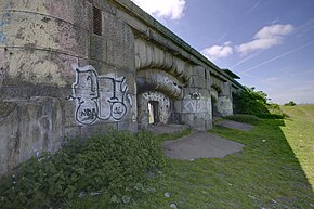
The fort is now in a mostly destroyed condition with only the front of the casemates standing above ground. Some tidying-up has been performed, but the ruins are vulnerable to vandalism. Nothing remains of the barracks and administrative buildings of the fort. The magazines still exist below ground;
475:
At some point between 1895 and 1907, Shornemead Fort was disarmed. Subsidence had made it structurally unsafe for its emplaced guns to be fired, and it was in any case strategically redundant by that point. It was used for a time by the Thames
Militia Division (Submarine Miners), Royal Engineers, as
433:
In the final design, the plan to put guns on the fort's roof were abandoned. Instead, eleven casemates were placed in an arc on one side of the D-shaped fort, pointing downriver towards Lower Hope Point. An open battery stood at the west end of the casemates, mounting three guns that pointed upriver
374:
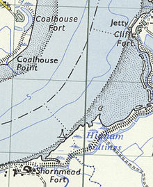
at Cliffe. The location of the forts would enable interlocking arcs of fire from their guns. It was originally intended that the forts would form part of a line of defences running all the way to
Chatham, but the rest of this chain was never built. Shornemead was regarded as being in a particularly
484:
operation. Aerial photographs from the time show the battery, fort, associated concrete pillboxes and searchlights surrounded by dense tangles of barbed wire. The fort was reduced to care and maintenance status in
November 1943, while the battery was deactivated in 1945 and demolished around 1976.
392:
capable of resisting direct artillery fire. They were over 635 mm (25.0 in) thick, with layers of steel and wood faced with granite. The original plans envisaged the roof of the fort being used to emplace fourteen guns behind shields and a masonry parapet. Two pivot guns and twenty other
237:
from seaborne attack. Constructed during a period of tension with France, it stands on the south bank of the river at a point where the Thames curves sharply north and west, giving the fort long views up and downriver in both directions. It was the third fort constructed on the site since the 18th
488:
The barrack accommodation of
Shornemead Fort was used for many years by soldiers training on the nearby Milton rifle range. A permanent staff was based at the fort, and the barracks included lecture rooms, staff accommodation and even a swimming pool built to the east of the fort. The fort was
242:. The fort was equipped for a time with a variety of large-calibre artillery guns which were intended to support two other nearby Thamesside forts. However, the extent of the subsidence meant that it became unsafe for the guns to be fired and the fort was disarmed by the early 20th century.
393:
guns would be housed at ground level within casemates. However, subsidence caused by the marshy ground was again a problem for the fort builders. The design could not be realised in its original form and it underwent substantial changes in 1867, part-way through construction.
281:
in the 16th and 17th centuries but these were inadequate against the threat of the new generation of artillery that had emerged by the end of the 18th century. An artillery battery was established farther downriver at
Shornemead in 1795–96, during the
383:
The third and final iteration of
Shornemead Fort was constructed between 1861 and 1870 at an estimated cost of £211,063. The fort and its counterparts at Coalhouse Point and Cliffe were designed, except for their ironwork, by Captain Siborne of the
388:. The iron and steel shields of their casemates were developed by Captain English and Lieutenant English of the Royal Engineers. It was substantially larger than its predecessor, replacing the vulnerable open emplacements with immensely strong
302:
to flank the fort's ditch. The marshy ground caused major problems and the fort was not completed until 1853. Subsidence badly cracked the cookhouse and barracks, and one of the caponiers split away from the rest of the structure.
447:
was filled in during the 1880s. The magazines underneath the casemates and open battery consisted of a line of storerooms for shells and cartridges, linked by a lighting passage at the rear and an ammunition passage at the front.
293:
the battery was abandoned. It was rebuilt in the mid-1840s, along with
Coalhouse Fort. The second Shornemead Fort was constructed between 1848–52 to a polygonal plan inspired by the ideas of the French military engineer
493:
and was demolished in the 1960s by the Army
Demolition School of the Royal Engineers as part of a training exercise. The staff accommodation and remains of the mining establishment were demolished in the 1970s.
257:
underneath, though the latter are now flooded and inaccessible. The surviving fragments of the fort and the area around it are part of a nature reserve and can be visited by the public.
442:. This was to enable artillery support for the older forts at those two towns, which were now relegated to the second line of defence. A single-storey defensible barracks built from
355:
331:
and the country's existing fortifications were largely obsolete. The Thames possessed several naval installations of great importance, including the victualling yards at
515:' Shorne Marshes Nature Reserve. It is linked to the Lower Higham Road by a concrete road originally built by the military to provide access, and is passed by the
347:. It was not possible for large warships to reach central London, as the river was not yet deep enough to take ships of more than 400 tons above Deptford. As the
472:
in separate emplacements to the west of the fort. Around the same time, a submarine mining establishment was constructed, also located to the west of the fort.
467:(RMLs) in casemates, with a range of 5.5 km (3.4 mi), plus another three 9-inch RMLs in the west-facing open battery. They were mounted on special
306:
By the late 1850s, Britain and France were locked in an arms race. A new generation of increasingly accurate and powerful guns had been developed (of the
245:
Shornemead Fort was in use from its completion in 1870 to its abandonment in the 1950s. Much of it was demolished by the Army
Demolition School of the
512:
145:
95:
419:
407:
806:
621:
549:
358:, which published a far-reaching report in 1860. It recommended that a triangle of forts should be established on the lower Thames, east of
295:
829:
854:
64:
375:
strategic location as it commanded river bends at which ships would have to slow down, making them more vulnerable.
849:
249:
in the 1960s. The barracks and administrative buildings have been completely destroyed and only the front of the
351:
soon showed, it was quite possible for the warships of the day to run past forts and attack up coastal rivers.
265:
511:
they are flooded and were sealed off in 2008. The site can be visited by the public, as it is now part of the
844:
708:
Wilson, J.D. (September 1963). "Later
Nineteenth Century Defences of the Thames, including Grain Fort".
640:
Wilson, J.D. (December 1963). "Later Nineteenth Century Defences of the Thames, including Grain Fort".
468:
455:
314:(RBL) types), mounted on fast-moving, manoeuvrable steam-powered ironclad warships such as the French
464:
311:
307:
254:
502:
48:
481:
348:
321:
683:
802:
617:
545:
370:
shore with a new fortification, similarly replacing the existing Shornemead Fort and building
443:
516:
477:
385:
328:
283:
246:
233:
is a now-disused artillery fort that was built in the 1860s to guard the entrance to the
824:
363:
340:
773:
838:
751:
577:
336:
130:
490:
39:
796:
611:
539:
371:
290:
239:
17:
110:
97:
435:
359:
316:
274:
327:. Britain's coastal defences had not been substantially upgraded since the
389:
344:
332:
299:
250:
202:
439:
278:
206:
238:
century, but its location on marshy ground led to major problems with
234:
736:
Saunders, Andrew; Smith, Victor (2001). "Shornemead Fort – KD 124".
501:
454:
367:
264:
480:
was constructed on the riverside below the fort to support the
541:
Discovering Fortifications: From the Tudors to the Cold War
463:
Shornemead Fort was initially equipped with eleven 11-inch
830:
Photographs of the flooded magazines under Shornemead Fort
273:
The Thames was guarded by a number of forts built around
269:
Map of the area of Cliffe, Coalhouse and Shornemead Forts
610:
Sutherland, R. J. M.; Humm, Dawn; Chrimes, Mike (2001).
53:
View of the exterior of the casemates of Shornemead Fort
544:. Princes Risborough: Shire Publications. p. 45.
356:
Royal Commission on the Defence of the United Kingdom
605:
603:
710:
Journal of the Society for Army Historical Research
642:
Journal of the Society for Army Historical Research
220:
212:
198:
190:
182:
174:
169:
161:
151:
141:
136:
126:
89:
31:
678:
676:
674:
672:
670:
668:
666:
664:
459:Interior of one of Shornemead Fort's casemates
8:
738:Kent's Defence Heritage – Gazetteer Part One
635:
633:
825:Photographs of Shornemead Fort in the 1920s
354:The government's response was to appoint a
613:Historic Concrete: Background to Appraisal
593:
591:
533:
531:
28:
513:Royal Society for the Protection of Birds
146:Royal Society for the Protection of Birds
571:
569:
567:
565:
563:
561:
527:
403:
362:. This would involve replacing the old
71:
731:
729:
727:
725:
723:
7:
801:. Aurum Press, Limited. p. 45.
425:Plan of the lower (magazines) level
413:Plan of the upper (casemates) level
774:"Pastscape – Monument No. 1547569"
616:. Thomas Telford. pp. 372–3.
25:
578:"Shornemead Fort, near Gravesend"
224:First World War, Second World War
418:
406:
70:
63:
47:
1:
795:Cowan, Bea (1 January 1996).
752:"Pastscape – Shornmead Fort"
576:Victor Smith (Autumn 1971).
339:, the shipbuilding yards at
489:abandoned after the end of
871:
582:Kent Archaeological Review
855:Forts on the River Thames
335:, the armaments works of
58:
46:
36:
519:long-distance footpath.
398:Plans of Shornemead Fort
253:survives along with the
538:Lowry, Bernard (2006).
343:, and the magazines at
740:. Kent County Council.
507:
460:
270:
111:51.446768°N 0.434059°E
505:
465:rifled muzzle loaders
458:
268:
312:Rifled Breech Loader
308:Rifled Muzzle Loader
289:After the defeat of
798:The Saxon Shore Way
451:Operational history
116:51.446768; 0.434059
107: /
776:. English Heritage
754:. English Heritage
508:
469:garrison carriages
461:
349:American Civil War
271:
142:Controlled by
808:978-1-85410-392-5
689:. Victorian Forts
623:978-0-7277-2875-3
551:978-0-7478-0651-6
372:a wholly new fort
261:Early development
228:
227:
165:Mostly demolished
16:(Redirected from
862:
850:Palmerston Forts
813:
812:
792:
786:
785:
783:
781:
770:
764:
763:
761:
759:
748:
742:
741:
733:
718:
717:
705:
699:
698:
696:
694:
688:
684:"Shornmead Fort"
680:
659:
656:
650:
649:
637:
628:
627:
607:
598:
595:
586:
585:
573:
556:
555:
535:
444:Kentish Ragstone
422:
410:
337:Woolwich Arsenal
320:and the British
137:Site information
122:
121:
119:
118:
117:
112:
108:
105:
104:
103:
100:
74:
73:
67:
51:
42:
29:
21:
870:
869:
865:
864:
863:
861:
860:
859:
835:
834:
821:
816:
809:
794:
793:
789:
779:
777:
772:
771:
767:
757:
755:
750:
749:
745:
735:
734:
721:
707:
706:
702:
692:
690:
686:
682:
681:
662:
657:
653:
639:
638:
631:
624:
609:
608:
601:
596:
589:
575:
574:
559:
552:
537:
536:
529:
525:
517:Saxon Shore Way
506:Inside the fort
500:
453:
431:
430:
429:
426:
423:
414:
411:
400:
399:
386:Royal Engineers
381:
329:Napoleonic Wars
284:Napoleonic Wars
263:
247:Royal Engineers
231:Shornemead Fort
154:the public
153:
115:
113:
109:
106:
101:
98:
96:
94:
93:
85:
84:
83:
82:
81:
80:
79:
78:Shornemead Fort
75:
54:
37:
32:Shornemead Fort
23:
22:
15:
12:
11:
5:
868:
866:
858:
857:
852:
847:
837:
836:
833:
832:
827:
820:
819:External links
817:
815:
814:
807:
787:
765:
743:
719:
700:
660:
651:
629:
622:
599:
587:
557:
550:
526:
524:
521:
499:
498:Current status
496:
452:
449:
428:
427:
424:
417:
415:
412:
405:
402:
401:
397:
396:
395:
380:
377:
364:Coalhouse Fort
341:North Woolwich
262:
259:
226:
225:
222:
218:
217:
214:
210:
209:
200:
196:
195:
192:
188:
187:
186:United Kingdom
184:
180:
179:
176:
172:
171:
167:
166:
163:
159:
158:
155:
149:
148:
143:
139:
138:
134:
133:
128:
124:
123:
91:
87:
86:
77:
76:
69:
68:
62:
61:
60:
59:
56:
55:
52:
44:
43:
34:
33:
24:
18:Shornmead Fort
14:
13:
10:
9:
6:
4:
3:
2:
867:
856:
853:
851:
848:
846:
845:Forts in Kent
843:
842:
840:
831:
828:
826:
823:
822:
818:
810:
804:
800:
799:
791:
788:
775:
769:
766:
753:
747:
744:
739:
732:
730:
728:
726:
724:
720:
715:
711:
704:
701:
685:
679:
677:
675:
673:
671:
669:
667:
665:
661:
655:
652:
647:
643:
636:
634:
630:
625:
619:
615:
614:
606:
604:
600:
594:
592:
588:
583:
579:
572:
570:
568:
566:
564:
562:
558:
553:
547:
543:
542:
534:
532:
528:
522:
520:
518:
514:
504:
497:
495:
492:
486:
483:
479:
473:
470:
466:
457:
450:
448:
445:
441:
437:
421:
416:
409:
404:
394:
391:
387:
378:
376:
373:
369:
365:
361:
357:
352:
350:
346:
342:
338:
334:
330:
326:
325:
319:
318:
313:
309:
304:
301:
297:
292:
287:
285:
280:
276:
267:
260:
258:
256:
252:
248:
243:
241:
236:
232:
223:
219:
215:
211:
208:
204:
201:
197:
193:
189:
185:
183:Built by
181:
177:
173:
168:
164:
160:
156:
150:
147:
144:
140:
135:
132:
131:Fortification
129:
125:
120:
92:
88:
66:
57:
50:
45:
41:
35:
30:
27:
19:
797:
790:
778:. Retrieved
768:
756:. Retrieved
746:
737:
713:
709:
703:
691:. Retrieved
658:Lowry, p. 88
654:
645:
641:
612:
597:Lowry, p. 60
581:
540:
509:
491:World War II
487:
474:
462:
432:
382:
379:Construction
353:
323:
315:
305:
296:Montalembert
288:
272:
244:
230:
229:
221:Battles/wars
170:Site history
152:Open to
40:Higham, Kent
26:
716:(167): 142.
648:(168): 182.
191:In use
178:ca. 1861–70
114: /
90:Coordinates
839:Categories
523:References
310:(RML) and
240:subsidence
213:Demolished
194:1870–1950s
99:51°26′48″N
436:Gravesend
390:casemates
360:Gravesend
322:HMS
317:La Gloire
300:caponiers
275:Gravesend
255:magazines
251:casemates
199:Materials
162:Condition
102:0°26′03″E
38:close to
345:Purfleet
333:Deptford
291:Napoleon
203:Concrete
440:Tilbury
434:toward
366:on the
324:Warrior
279:Tilbury
207:granite
805:
780:2 June
758:2 June
693:1 June
620:
548:
235:Thames
687:(PDF)
584:(25).
482:D-Day
368:Essex
216:1960s
175:Built
803:ISBN
782:2015
760:2015
695:2015
618:ISBN
546:ISBN
478:hard
438:and
277:and
127:Type
714:XLI
646:XLI
157:Yes
841::
722:^
712:.
663:^
644:.
632:^
602:^
590:^
580:.
560:^
530:^
205:,
811:.
784:.
762:.
697:.
626:.
554:.
20:)
Text is available under the Creative Commons Attribution-ShareAlike License. Additional terms may apply.