721:
43:
236:
283:
Si Thep is on a dry highland surrounded by waterways and floodplains bordered by mountains on both sides. To ensure sufficient water for city use, ancient Si Thep had an elaborate system of ponds, tank moats, and a hydraulic system to bring water from higher grounds to sustain the city.
762:
629:
791:
781:
59:
520:
755:
622:
42:
748:
242:, was an ancient Dvaravati-style stupa, dated back around 8th-9th century CE, at present, it is large laterite base.
653:
615:
333:) Sawang Watthana covers parts of tambon Sa Kruat. There are seven tambon administrative organizations (TAO).
688:
272:
577:
673:
638:
300:
288:
268:
253:
101:
545:
728:
642:
602:
296:
292:
220:
106:
48:
786:
698:
683:
658:
703:
693:
668:
663:
304:
164:
227:. Si Thep, is Thailand’s latest World Heritage Sites, and Thailand's largest ancient city.
329:
565:
732:
264:
775:
209:
197:
720:
235:
224:
248:
172:
355:
74:
61:
260:
155:
607:
33:
182:
91:
317:
215:
160:
323:
246:
The district was created on 13 December 1970 as a minor district (
234:
611:
256:. It was upgraded to Si Thep District on 8 August 1976.
736:
267:
found the area of the old city in 1905 when he visited
287:
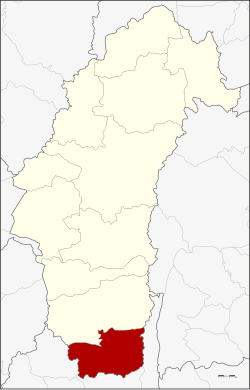
Neighboring districts are (from the north clockwise)
181:
171:
154:
146:
138:
133:
125:
120:
112:
100:
90:
21:
321:), which are further subdivided into 93 villages (
315:The district is divided into seven sub-districts (
756:
623:
514:
512:
259:The ancient city of Si Thep was built in the
8:
763:
749:
630:
616:
608:
18:
521:"Opening minds with an ancient 'mandala'"
519:Ekachai, Sanitsuda (28 September 2019).
508:
180:
170:
153:
132:
119:
89:
54:
39:
208:
145:
137:
129:810.0 km (312.7 sq mi)
124:
111:
99:
7:
717:
715:
603:Si Thep Historical Park by Finearts
14:
792:Northern Thailand geography stubs
546:"Virtual Si Thep Historical Park"
223:, Thailand, in the valley of the
782:Districts of Phetchabun province
719:
578:"Ancient Thailand, under threat"
213:) is the southernmost district (
41:
16:District in Phetchabun, Thailand
1:
735:. You can help Knowledge by
291:of Phetchabun Province, and
808:
714:
649:
201:
55:
40:
31:
150:78.1/km (202/sq mi)
25:
273:Si Thep Historical Park
731:location article is a
252:) with territory from
243:
75:15.45333°N 101.06722°E
254:Wichian Buri district
238:
47:District location in
147: • Density
729:Phetchabun Province
221:Phetchabun province
80:15.45333; 101.06722
71: /
49:Phetchabun province
269:Monthon Phetchabun
244:
210:[sǐːtʰêːp]
139: • Total
126: • Total
744:
743:
712:
711:
654:Mueang Phetchabun
500:
499:
494:
493:
327:). The township (
191:
190:
799:
765:
758:
751:
723:
716:
632:
625:
618:
609:
590:
589:
587:
585:
580:. March 7, 2019
574:
568:
563:
557:
556:
554:
552:
542:
536:
535:
533:
531:
516:
340:
339:
336:
335:
305:Lopburi province
212:
207:
203:
86:
85:
83:
82:
81:
76:
72:
69:
68:
67:
64:
45:
19:
807:
806:
802:
801:
800:
798:
797:
796:
772:
771:
770:
769:
713:
708:
645:
636:
599:
594:
593:
583:
581:
576:
575:
571:
564:
560:
550:
548:
544:
543:
539:
529:
527:
518:
517:
510:
505:
405:Khlong Krachang
330:thesaban tambon
313:
281:
240:Khao Khlang Nok
233:
205:
79:
77:
73:
70:
65:
62:
60:
58:
57:
51:
36:
27:
24:
17:
12:
11:
5:
805:
803:
795:
794:
789:
784:
774:
773:
768:
767:
760:
753:
745:
742:
741:
724:
710:
709:
707:
706:
701:
696:
691:
689:Bueng Sam Phan
686:
681:
676:
671:
666:
661:
656:
650:
647:
646:
637:
635:
634:
627:
620:
612:
606:
605:
598:
597:External links
595:
592:
591:
569:
558:
537:
507:
506:
504:
501:
498:
497:
495:
492:
491:
489:
486:
483:
480:
477:
473:
472:
470:
467:
464:
461:
460:Nong Yang Thoi
458:
454:
453:
451:
448:
445:
442:
439:
435:
434:
432:
429:
426:
423:
420:
416:
415:
412:
409:
406:
403:
399:
398:
396:
393:
390:
387:
384:
380:
379:
377:
374:
371:
368:
365:
361:
360:
358:
353:
350:
347:
344:
312:
311:Administration
309:
280:
277:
265:Prince Damrong
232:
229:
189:
188:
185:
179:
178:
175:
169:
168:
158:
152:
151:
148:
144:
143:
140:
136:
135:
131:
130:
127:
123:
122:
118:
117:
114:
110:
109:
104:
98:
97:
94:
88:
87:
53:
52:
46:
38:
37:
32:
29:
28:
22:
15:
13:
10:
9:
6:
4:
3:
2:
804:
793:
790:
788:
785:
783:
780:
779:
777:
766:
761:
759:
754:
752:
747:
746:
740:
738:
734:
730:
725:
722:
718:
705:
702:
700:
697:
695:
692:
690:
687:
685:
682:
680:
677:
675:
672:
670:
667:
665:
662:
660:
657:
655:
652:
651:
648:
644:
640:
633:
628:
626:
621:
619:
614:
613:
610:
604:
601:
600:
596:
579:
573:
570:
567:
562:
559:
547:
541:
538:
526:
522:
515:
513:
509:
502:
496:
490:
487:
484:
481:
478:
475:
474:
471:
468:
465:
462:
459:
456:
455:
452:
449:
446:
443:
440:
437:
436:
433:
430:
427:
424:
421:
418:
417:
413:
410:
407:
404:
401:
400:
397:
394:
391:
388:
385:
382:
381:
378:
375:
372:
369:
366:
363:
362:
359:
357:
354:
351:
348:
345:
342:
341:
338:
337:
334:
332:
331:
326:
325:
320:
319:
310:
308:
306:
302:
298:
294:
290:
285:
278:
276:
274:
270:
266:
262:
261:Dvaravati era
257:
255:
251:
250:
241:
237:
230:
228:
226:
222:
218:
217:
211:
199:
195:
186:
184:
176:
174:
166:
162:
159:
157:
149:
141:
128:
115:
108:
105:
103:
95:
93:
84:
56:Coordinates:
50:
44:
35:
30:
20:
737:expanding it
726:
678:
674:Wichian Buri
582:. Retrieved
572:
561:
549:. Retrieved
540:
530:28 September
528:. Retrieved
525:Bangkok Post
524:
328:
322:
316:
314:
301:Khok Charoen
289:Wichian Buri
286:
282:
271:. It is now
258:
247:
245:
239:
225:Pa Sak River
214:
193:
192:
463:หนองย่างทอย
249:king amphoe
173:Postal code
78: /
776:Categories
643:Phetchabun
566:amphoe.com
503:References
479:Pradu Ngam
441:Khok Sa-at
408:คลองกระจัง
349:Thai name
297:Chai Badan
293:Lam Sonthi
206:pronounced
134:Population
116:Khok Sa-at
107:Phetchabun
63:15°27′12″N
787:Dvaravati
699:Wang Pong
684:Nong Phai
659:Chon Daen
639:Districts
584:March 11,
551:March 11,
482:ประดู่งาม
352:Villages
279:Geography
156:Time zone
66:101°4′2″E
704:Khao Kho
444:โคกสะอาด
422:Na Sanun
386:Sa Kruat
102:Province
96:Thailand
34:District
694:Nam Nao
679:Si Thep
669:Lom Kao
664:Lom Sak
425:นาสนุ่น
414:13,554
389:สระกรวด
367:Si Thep
318:tambons
231:History
194:Si Thep
183:Geocode
92:Country
23:Si Thep
431:11,011
395:15,731
376:10,465
370:ศรีเทพ
324:mubans
299:, and
216:amphoe
202:ศรีเทพ
142:63,300
26:ศรีเทพ
727:This
488:3,024
469:9,353
450:6,748
346:Name
219:) of
177:67170
161:UTC+7
733:stub
586:2021
553:2021
532:2019
356:Pop.
343:No.
198:Thai
187:6706
121:Area
113:Seat
641:of
303:of
165:ICT
778::
523:.
511:^
476:7.
466:12
457:6.
447:13
438:5.
428:20
419:4.
411:18
402:3.
392:17
383:2.
373:15
364:1.
307:.
295:,
275:.
263:.
204:,
200::
764:e
757:t
750:v
739:.
631:e
624:t
617:v
588:.
555:.
534:.
485:8
196:(
167:)
163:(
Text is available under the Creative Commons Attribution-ShareAlike License. Additional terms may apply.