139:
144:
128:
538:. A glacier on the southeast side of Platform Spur, flowing northeast into Emmanuel Glacier. Named by US-ACAN in 1992 after Kenneth C. Jezek, geophysicist with CRREL and NOAA, 1983-89; in 12 visits to the Arctic and Antarctic, conducted geophysical surveys using remote sensing techniques on measurement and properties of terrestrial ice and sea ice with work at Dome Charlie, Ross Ice Shelf and Weddell Sea; Director, Byrd Polar Research Center, from 1989.
133:
342:. A shallow hanging valley, 1 nautical mile (1.9 km; 1.2 mi) long, running northwest parallel to Columnar Valley and terminating just west of the summit of Table Mountain. Named from the distinctive rock formations along its northwest wall, one of which is a particularly good likeness of the Egyptian Sphinx. Named by Alan Sherwood, NZGS party leader in the area, 1987-88.
759:
380:. An elongated massif 1.5 nautical miles (2.8 km; 1.7 mi) southwest of Table Mountain in the northwest part of Royal Society Range. The feature was descriptively named by Alan Sherwood, NZGS field party leader in the area, 1987-88. Its size and position in relation to an associated ridge suggest a handle to a sickle.
457:
A cluster of prominent peaks that rise to 3,091 metres (10,141 ft) high at the south end of Sickle Ridge, Royal
Society Range, Victoria Land. Named by Advisory Committee on Antarctic Names (US-ACAN) (1994) after the Murcray brothers, David G. and Frank H., and Frank J. Murcray (son of David
418:
A sickle-shaped ridge, 5 nautical miles (9.3 km; 5.8 mi) long and rising to over 2,600 metres (8,500 ft) high. The ridge extends southward from The Handle between Tedrow
Glacier and Emmanuel Glacier and terminates at Murcray Heights. Named descriptively by New Zealand Geographic
588:. Named by Advisory Committee on Antarctic Names (US-ACAN) (1995) after James G. Bockheim, Department of Soil Science, University of Wisconsin, Madison, who made soil development studies of McMurdo Dry Valleys in 12 field seasons during the 1970s and 1980s.
304:. A sandstone butte which displays large-scale cross bedding, rising from the south-central part of Table Mountain. Named by Alan Sherwood, NZGS party leader in the area, 1987-88, after the famous Navajo sandstone of Utah.
763:
220:. A flattish rock spur that separates the lower ends of Blankenship Glacier and Tedrow Glacier, to the west of Table Mountain. The name is one of a group in the area associated with surveying applied in 1993 by
500:
and Jezek
Glacier in the northwest part of Royal Society Range, Victoria Land. It was descriptively named by Alan Sherwood, NZGS party leader in the area, 1987-88.
262:. A valley trending northwest between The Handle and Table Mountain in the northwest part of Royal Society Range. Descriptively named by Alan Sherwood,
830:
809:
788:
767:
548:
429:
847:
821:
800:
779:
816:
795:
774:
390:
85:
826:
805:
784:
510:
468:
352:
314:
276:
234:
192:
36:
496:. A wedge-shaped sandstone platform which rises to 2,350 metres (7,710 ft) high and tapers to the northeast, between
263:
221:
224:(NZGB). A bubble on a surveying instrument is used to indicate its directional tilt and to facilitate its leveling.
112:
266:(NZGS) field party leader in the area, 1987-88, after the columnar-jointed dolerite that forms the valley walls.
107:
64:) is a large flat mountain rising to over 2,000 metres (6,600 ft) immediately south of the junction of the
419:
Board (NZGB) (1994) following work in the area in the 1987-88 field season by NZGS geologist Alan
Sherwood.
102:
138:
497:
143:
171:
155:
127:
72:
in
Victoria Land. Discovered and given this descriptive name by the BrNAE (1901–04) under Scott.
132:
585:
167:
65:
97:
458:
G.), University of Denver, long term specialists in infrared spectroscopy in
Antarctica.
581:
163:
159:
69:
170:
also flows north to the Ferrar
Glacier. Ridges extend south from the mountain towards
841:
166:, which runs east past the north face of the mountain. To the east of the mountain,
741:
577:
563:
550:
525:
512:
483:
470:
444:
431:
405:
392:
367:
354:
329:
316:
291:
278:
249:
236:
207:
194:
51:
38:
17:
576:
A peak, 2,749 metres (9,019 ft) high, at the northwest end of
182:
Features of the mountain, and nearby features include:
149:
Table
Mountain in the center, where the four maps meet
749:(2 ed.), United States Board on Geographic Names
687:
723:
675:
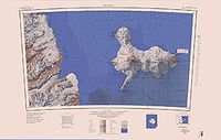
154:Table Mountain is the northwest point of the
8:
580:. The peak is bordered north and south by
831:United States Department of the Interior
810:United States Department of the Interior
789:United States Department of the Interior
768:United States Board on Geographic Names
711:
699:
663:
651:
639:
627:
615:
603:
596:
7:
822:Geographic Names Information System
801:Geographic Names Information System
780:Geographic Names Information System
766:from websites or documents of the
25:
743:Geographic Names of the Antarctic
762: This article incorporates
757:
162:, which flows north to join the
142:
137:
131:
126:
827:United States Geological Survey
806:United States Geological Survey
785:United States Geological Survey
740:Alberts, Fred G., ed. (1995),
1:
264:New Zealand Geological Survey
222:New Zealand Geographic Board
113:GPX (secondary coordinates)
864:
848:Mountains of Victoria Land
564:78.0352778°S 161.9633333°E
445:78.0833333°S 162.2166667°E
158:. It lies to the east of
108:GPX (primary coordinates)
83:Map all coordinates using
569:-78.0352778; 161.9633333
450:-78.0833333; 162.2166667
406:78.016667°S 162.166667°E
91:Download coordinates as:
764:public domain material
411:-78.016667; 162.166667
27:Mountain in Antarctica
103:GPX (all coordinates)
688:Murcray Heights USGS
498:Bindschadler Glacier
724:Mount Bockheim USGS
560: /
522: /
480: /
441: /
402: /
364: /
326: /
288: /
246: /
204: /
172:Johns Hopkins Ridge
156:Royal Society Range
48: /
526:77.983°S 162.217°E
484:77.983°S 162.167°E
368:78.000°S 161.983°E
330:77.983°S 162.017°E
292:77.967°S 162.050°E
250:77.967°S 161.950°E
208:77.983°S 161.833°E
52:77.950°S 162.000°E
796:"Murcray Heights"
676:Sickle Ridge USGS
16:(Redirected from
855:
833:
812:
791:
775:"Mount Bockheim"
761:
760:
756:
755:
754:
748:
727:
721:
715:
709:
703:
697:
691:
685:
679:
673:
667:
661:
655:
649:
643:
637:
631:
625:
619:
613:
607:
601:
586:Matataua Glacier
575:
574:
572:
571:
570:
565:
561:
558:
557:
556:
553:
537:
536:
534:
533:
532:
531:-77.983; 162.217
527:
523:
520:
519:
518:
515:
495:
494:
492:
491:
490:
489:-77.983; 162.167
485:
481:
478:
477:
476:
473:
456:
455:
453:
452:
451:
446:
442:
439:
438:
437:
434:
417:
416:
414:
413:
412:
407:
403:
400:
399:
398:
395:
379:
378:
376:
375:
374:
373:-78.000; 161.983
369:
365:
362:
361:
360:
357:
341:
340:
338:
337:
336:
335:-77.983; 162.017
331:
327:
324:
323:
322:
319:
303:
302:
300:
299:
298:
297:-77.967; 162.050
293:
289:
286:
285:
284:
281:
261:
260:
258:
257:
256:
255:-77.967; 161.950
251:
247:
244:
243:
242:
239:
219:
218:
216:
215:
214:
213:-77.983; 161.833
209:
205:
202:
201:
200:
197:
168:Emmanuel Glacier
146:
141:
135:
130:
66:Emmanuel Glacier
63:
62:
60:
59:
58:
57:-77.950; 162.000
53:
49:
46:
45:
44:
41:
21:
863:
862:
858:
857:
856:
854:
853:
852:
838:
837:
836:
815:
794:
773:
758:
752:
750:
746:
739:
735:
730:
722:
718:
710:
706:
698:
694:
686:
682:
674:
670:
662:
658:
650:
646:
638:
634:
626:
622:
614:
610:
602:
598:
594:
568:
566:
562:
559:
554:
551:
549:
547:
546:
544:
530:
528:
524:
521:
516:
513:
511:
509:
508:
506:
488:
486:
482:
479:
474:
471:
469:
467:
466:
464:
449:
447:
443:
440:
435:
432:
430:
428:
427:
425:
423:Murcray Heights
410:
408:
404:
401:
396:
393:
391:
389:
388:
386:
372:
370:
366:
363:
358:
355:
353:
351:
350:
348:
334:
332:
328:
325:
320:
317:
315:
313:
312:
310:
296:
294:
290:
287:
282:
279:
277:
275:
274:
272:
254:
252:
248:
245:
240:
237:
235:
233:
232:
230:
228:Columnar Valley
212:
210:
206:
203:
198:
195:
193:
191:
190:
188:
180:
152:
151:
150:
147:
121:
120:
119:
118:
117:
78:
56:
54:
50:
47:
42:
39:
37:
35:
34:
28:
23:
22:
15:
12:
11:
5:
861:
859:
851:
850:
840:
839:
835:
834:
817:"Sickle Ridge"
813:
792:
771:
736:
734:
731:
729:
728:
716:
714:, p. 372.
704:
702:, p. 580.
692:
680:
668:
666:, p. 309.
656:
654:, p. 701.
644:
642:, p. 518.
632:
630:, p. 146.
620:
618:, p. 100.
608:
606:, p. 731.
595:
593:
590:
582:Tedrow Glacier
543:
542:Mount Bockheim
540:
505:
502:
463:
460:
424:
421:
385:
382:
347:
344:
309:
306:
271:
268:
229:
226:
187:
184:
179:
176:
164:Ferrar Glacier
160:Tedrow Glacier
148:
124:
123:
122:
116:
115:
110:
105:
100:
94:
88:
81:
80:
79:
77:
74:
70:Ferrar Glacier
31:Table Mountain
26:
24:
14:
13:
10:
9:
6:
4:
3:
2:
860:
849:
846:
845:
843:
832:
828:
824:
823:
818:
814:
811:
807:
803:
802:
797:
793:
790:
786:
782:
781:
776:
772:
769:
765:
745:
744:
738:
737:
732:
725:
720:
717:
713:
708:
705:
701:
696:
693:
689:
684:
681:
677:
672:
669:
665:
660:
657:
653:
648:
645:
641:
636:
633:
629:
624:
621:
617:
612:
609:
605:
600:
597:
591:
589:
587:
583:
579:
573:
541:
539:
535:
504:Jezek Glacier
503:
501:
499:
493:
462:Platform Spur
461:
459:
454:
422:
420:
415:
383:
381:
377:
345:
343:
339:
308:Sphinx Valley
307:
305:
301:
269:
267:
265:
259:
227:
225:
223:
217:
185:
183:
177:
175:
173:
169:
165:
161:
157:
145:
140:
136:
134:
129:
114:
111:
109:
106:
104:
101:
99:
96:
95:
93:
92:
87:
86:OpenStreetMap
84:
75:
73:
71:
67:
61:
32:
19:
820:
799:
778:
751:, retrieved
742:
719:
712:Alberts 1995
707:
700:Alberts 1995
695:
683:
671:
664:Alberts 1995
659:
652:Alberts 1995
647:
640:Alberts 1995
635:
628:Alberts 1995
623:
616:Alberts 1995
611:
604:Alberts 1995
599:
545:
507:
465:
426:
387:
384:Sickle Ridge
349:
311:
273:
270:Navajo Butte
231:
189:
181:
153:
125:
90:
89:
82:
30:
29:
18:Sickle Ridge
578:Maine Ridge
567: /
555:161°57′48″E
529: /
487: /
448: /
436:162°13′00″E
409: /
397:162°10′00″E
371: /
333: /
295: /
253: /
211: /
186:Bubble Spur
55: /
753:2023-12-03
592:References
552:78°02′07″S
433:78°05′00″S
394:78°01′00″S
346:The Handle
842:Category
517:162°13′E
475:162°10′E
359:161°59′E
321:162°01′E
283:162°03′E
241:161°57′E
199:161°50′E
178:Features
76:Location
43:162°00′E
733:Sources
514:77°59′S
472:77°59′S
356:78°00′S
318:77°59′S
280:77°58′S
238:77°58′S
196:77°59′S
40:77°57′S
747:(PDF)
584:and
68:and
98:KML
844::
829:,
825:,
819:,
808:,
804:,
798:,
787:,
783:,
777:,
174:.
770:.
726:.
690:.
678:.
33:(
20:)
Text is available under the Creative Commons Attribution-ShareAlike License. Additional terms may apply.