265:
33:
346:. Mexico once claimed the portion of Belize north of the Sibun River but dropped the claim in a treaty with Britain in 1893. Since then, Mexico has stated that it would revive the claim only if Guatemala were successful in obtaining all or part of the nation.
283:, at approximately 800 meters above sea level, where the Sibun is known as the Caves Branch River. The river then flows through a gorge until it reaches an alluvial floodplain, where citrus and cacao plantations exist. Here the river valley is flanked by
426:
Monacci, Natalie M.; Meier-Grünhagen, Ursula; Finney, Bruce P.; Behling, Hermann; Wooller, Matthew J. (2011-09-01). "Paleoecology of mangroves along the Sibun River, Belize".
343:
334:
has claimed all
Belizean land south of the Sibun River, although the claim is not internationally recognized. The current internationally accepted southern
530:
416:, Institute for Mesoamerican Studies Occasional Publication 8. Institute for Mesoamerican Studies at the State University of New York, Albany.
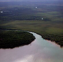
301:) are common along its banks; along the stretch of river between the coast and the village, mangroves are predominant. It empties into the
554:
184:
462:
559:
523:
335:
105:
516:
549:
351:
324:
316:
features several vegetation types, including tropical evergreen seasonal mixed needle forest, broadleaf forest,
297:
269:
264:
373:
443:
461:
Lauterpacht, Elihu; Stephen
Schwebel; Shabtai Rosenne; Francisco Orrego Vicuña (November 2001).
500:
435:
284:
288:
339:
313:
292:
280:
91:
37:
The characteristic meanders of the lower reaches of the Sibun before it flows into the
543:
469:
447:
302:
229:
166:
38:
378:
258:
439:
306:
170:
151:
327:
is a local organization focused on environmental issues within the watershed.
276:
199:
186:
120:
107:
403:. Sibun Watershed Association and The Government Printer, Belmopan, Belize.
331:
349:
The lower reaches of the river are prominent in scenes from the 1986 film
317:
32:
250:
62:
263:
254:
253:
which drains a large central portion of the country. The Sibun (
463:"Legal Opinion on Guatemala's Territorial Claim to Belize"
414:
Sacred
Landscape and Settlement in the Sibun River Valley
412:
McAnany, Patricia A., and Ben S. Thomas, editors (2002).
504:
225:
215:
176:
160:
150:
136:
97:
85:
77:
68:
58:
53:
45:
21:
499:This article related to a river in Belize is a
524:
8:
531:
517:
291:. Before the river reaches the village of
279:of the Sibun River are located within the
364:
344:Belizean–Guatemalan territorial dispute
342:. The claim is central to the ongoing
18:
372:Sharper, Willand (4 September 2011).
7:
496:
494:
503:. You can help Knowledge (XXG) by
14:
261:people who inhabited the region.
31:
401:The Sibun River Watershed Atlas
295:, river figs and spiny bamboo (
178: • coordinates
99: • coordinates
1:
69:Physical characteristics
217: • elevation
138: • elevation
468:. p. 7. Archived from
440:10.1016/j.yqres.2011.06.001
325:Sibun Watershed Association
162: • location
87: • location
576:
493:
336:Belizean–Guatemalan border
142:600 m (2,000 ft)
555:North America river stubs
169:10 km south-west of
146:
73:
30:
49:The ancient Xibun Mayans
25:Sibun River, Xibun River
268:Sibun River, view from
560:Belize geography stubs
272:
267:
221:0 m (0 ft)
475:on 12 November 2012
428:Quaternary Research
320:, and agriculture.
270:Hummingbird Highway
196: /
117: /
399:Boles, Ed (1999).
352:The Mosquito Coast
273:
512:
511:
298:Guadua longifolia
235:
234:
200:17.417°N 88.250°W
121:17.067°N 88.733°W
567:
550:Rivers of Belize
533:
526:
519:
495:
485:
484:
482:
480:
474:
467:
458:
452:
451:
423:
417:
410:
404:
397:
391:
390:
388:
386:
374:"Think About It"
369:
312:The Sibun River
285:karst topography
249:) is a river in
211:
210:
208:
207:
206:
201:
197:
194:
193:
192:
189:
139:
132:
131:
129:
128:
127:
122:
118:
115:
114:
113:
110:
100:
88:
35:
19:
575:
574:
570:
569:
568:
566:
565:
564:
540:
539:
538:
537:
491:
489:
488:
478:
476:
472:
465:
460:
459:
455:
425:
424:
420:
411:
407:
398:
394:
384:
382:
371:
370:
366:
361:
289:Maya cave sites
257:) were ancient
218:
205:17.417; -88.250
204:
202:
198:
195:
190:
187:
185:
183:
182:
179:
163:
137:
126:17.067; -88.733
125:
123:
119:
116:
111:
108:
106:
104:
103:
98:
86:
41:
26:
23:
17:
16:River in Belize
12:
11:
5:
573:
571:
563:
562:
557:
552:
542:
541:
536:
535:
528:
521:
513:
510:
509:
487:
486:
453:
434:(2): 220–228.
418:
405:
392:
363:
362:
360:
357:
340:Sarstoon River
293:Freetown Sibun
281:Maya Mountains
233:
232:
227:
223:
222:
219:
216:
213:
212:
180:
177:
174:
173:
164:
161:
158:
157:
154:
148:
147:
144:
143:
140:
134:
133:
101:
95:
94:
92:Maya Mountains
89:
83:
82:
79:
75:
74:
71:
70:
66:
65:
60:
56:
55:
51:
50:
47:
43:
42:
36:
28:
27:
24:
15:
13:
10:
9:
6:
4:
3:
2:
572:
561:
558:
556:
553:
551:
548:
547:
545:
534:
529:
527:
522:
520:
515:
514:
508:
506:
502:
497:
492:
471:
464:
457:
454:
449:
445:
441:
437:
433:
429:
422:
419:
415:
409:
406:
402:
396:
393:
381:
380:
375:
368:
365:
358:
356:
354:
353:
347:
345:
341:
337:
333:
328:
326:
321:
319:
315:
310:
308:
304:
303:Caribbean Sea
300:
299:
294:
290:
286:
282:
278:
271:
266:
262:
260:
256:
252:
248:
247:Sheboon River
244:
240:
231:
230:Caribbean Sea
228:
224:
220:
214:
209:
181:
175:
172:
168:
167:Caribbean Sea
165:
159:
155:
153:
149:
145:
141:
135:
130:
102:
96:
93:
90:
84:
80:
76:
72:
67:
64:
61:
57:
52:
48:
44:
40:
34:
29:
22:Sheboon River
20:
505:expanding it
498:
490:
477:. Retrieved
470:the original
456:
431:
427:
421:
413:
408:
400:
395:
383:. Retrieved
379:Belize Times
377:
367:
350:
348:
329:
322:
311:
296:
274:
246:
242:
238:
236:
479:10 November
385:27 February
330:Since 1999
307:Belize City
305:, south of
245:, formerly
243:Xibun River
239:Sibun River
203: /
171:Belize City
124: /
544:Categories
359:References
287:featuring
277:headwaters
226:Basin size
448:129882614
332:Guatemala
318:mangroves
314:Watershed
46:Etymology
39:Caribbean
54:Location
338:is the
191:88°15′W
188:17°25′N
112:88°44′W
109:17°04′N
59:Country
446:
251:Belize
156:
81:
78:Source
63:Belize
473:(PDF)
466:(PDF)
444:S2CID
255:Xibun
152:Mouth
501:stub
481:2012
387:2020
323:The
275:The
259:Maya
237:The
436:doi
546::
442:.
432:76
430:.
376:.
355:.
309:.
532:e
525:t
518:v
507:.
483:.
450:.
438::
389:.
241:(
Text is available under the Creative Commons Attribution-ShareAlike License. Additional terms may apply.