170:
31:
235:
A secondary summit of the hill (height 329 m) is capped by a monument to the New
Zealand Centennial of 1940, a large structure including two large bronze figures representing "History" and "The Thread of Life" designed by F. A. Shurrock and F. W. Staub. (colloquially known as 'the buddhas' in local
262:
The monument is surrounded by a scenic reserve 180 hectares in extent. This park was inaugurated as a much smaller park in 1926, and has gradually been extended to its current size. The reserve, located only five kilometres from central
Dunedin, is a popular site for both locals and visitors, and
347:
63:
35:
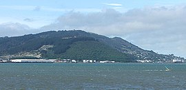
Signal Hill, viewed from the south, across Otago
Harbour. Logan Point quarry is visible to the left, and the suburb of Ravensbourne to the right
352:
266:
In
October 2006, a series of bush fires caused extensive damage to the plantations of forest which cover the western slopes of the hill.
173:
The view looking south across central
Dunedin and the head of the Otago Harbour, from the New Zealand Centennial monument on Signal Hill
342:
357:
337:
229:
56:
225:
221:
201:
332:
284:
205:
228:. The southernmost spur of Signal Hill, Logan Point, has been extensively quarried for road gravel.
240:
213:
181:
111:
212:
lie on its southern, eastern, and northwestern flanks, respectively. To the northwest is
243:, the monument was not constructed until the 1950s, owing to the enforced strictures of
326:
197:
255:
is also incorporated in the monument, symbolising the ties between
Dunedin and its
244:
256:
193:
128:
169:
78:
65:
248:
236:
slang for their similarities to the sitting posture of the buddha figure).
30:
252:
217:
189:
148:
46:
232:
skirts the foot of the hill close to the edge of the Otago
Harbour.
200:
and reaches an elevation of 393 m (1289 ft). The suburbs
209:
168:
138:
239:
Although commissioned for the centenary of the signing of the
196:. It is located close to, and due north of, the head of the
293:
climb to the top of Signal Hill and visit "the buddhas"
263:affords an excellent panoramic view over the city.
159:
154:
144:
134:
124:
119:
99:
94:
55:
45:
40:
23:
285:"Rediscovering freedom: Stadium to Signal Hill"
8:
103:
20:
315:Herd, J. & Griffiths, G. J. (1980).
188:) is a prominent landform in the city of
275:
7:
308:Bishop, G. & Hamel, A. (1993).
14:
29:
283:Fraser, Clare (24 April 2020).
348:Tourist attractions in Dunedin
1:
353:Urban forests in New Zealand
16:Hill in Dunedin, New Zealand
374:
186:Te Pahuri o te Rangipohika
105:Te Pahuri o te Rangipohika
51:393 m (1,289 ft)
28:
343:Protected areas of Otago
319:. Dunedin: John McIndoe.
312:. Dunedin: John McIndoe.
310:From Sea to Silver Peaks
358:Lookouts in New Zealand
163:Dunedin Volcano complex
247:. A large stone from
185:
174:
104:
79:45.84972°S 170.55944°E
224:, a tributary of the
172:
338:Geography of Dunedin
160:Volcanic region
84:-45.84972; 170.55944
317:Discovering Dunedin
75: /
241:Treaty of Waitangi
175:
41:Highest point
289:Otago Daily Times
214:North East Valley
167:
166:
365:
296:
295:
280:
230:State Highway 88
115:
107:
90:
89:
87:
86:
85:
80:
76:
73:
72:
71:
68:
33:
21:
373:
372:
368:
367:
366:
364:
363:
362:
323:
322:
305:
303:Further reading
300:
299:
282:
281:
277:
272:
109:
83:
81:
77:
74:
69:
66:
64:
62:
61:
36:
17:
12:
11:
5:
371:
369:
361:
360:
355:
350:
345:
340:
335:
333:Hills of Otago
325:
324:
321:
320:
313:
304:
301:
298:
297:
274:
273:
271:
268:
226:Water of Leith
165:
164:
161:
157:
156:
152:
151:
146:
142:
141:
136:
132:
131:
126:
122:
121:
117:
116:
101:
97:
96:
92:
91:
59:
53:
52:
49:
43:
42:
38:
37:
34:
26:
25:
15:
13:
10:
9:
6:
4:
3:
2:
370:
359:
356:
354:
351:
349:
346:
344:
341:
339:
336:
334:
331:
330:
328:
318:
314:
311:
307:
306:
302:
294:
290:
286:
279:
276:
269:
267:
264:
260:
258:
254:
250:
246:
242:
237:
233:
231:
227:
223:
222:Lindsay Creek
219:
215:
211:
207:
203:
199:
198:Otago Harbour
195:
191:
187:
183:
179:
171:
162:
158:
153:
150:
147:
143:
140:
137:
133:
130:
127:
123:
118:
113:
106:
102:
98:
93:
88:
60:
58:
54:
50:
48:
44:
39:
32:
27:
22:
19:
316:
309:
292:
288:
278:
265:
261:
245:World War II
238:
234:
206:St. Leonards
202:Ravensbourne
177:
176:
18:
257:sister city
194:New Zealand
178:Signal Hill
129:New Zealand
100:Native name
82: /
70:170°33′34″E
57:Coordinates
24:Signal Hill
327:Categories
270:References
67:45°50′59″S
249:Edinburgh
120:Geography
47:Elevation
253:Scotland
145:District
218:thalweg
190:Dunedin
155:Geology
149:Dunedin
125:Country
216:, the
208:, and
135:Region
108:
95:Naming
210:Opoho
182:Māori
139:Otago
112:Māori
251:in
220:of
329::
291:.
287:.
259:.
204:,
192:,
184::
180:(
114:)
110:(
Text is available under the Creative Commons Attribution-ShareAlike License. Additional terms may apply.