148:
33:
130:
289:
to symbolize the relief (a granularity of 10 metres (33 ft) for the 1:25 000 pages, and 30 metres (98 ft) for the 1:50 000 pages). In addition, three colors were used directly for printing, whereas the Dufour Map was initially monochrome. On the
Siegfried Map, the colours used were brown
281:
The area covered by the former scale was initially divided into 462 pages, and the other area into 142 pages, with the two areas overlapping in places. A format of 35 centimetres (14 in) x 24 centimetres (9.4 in) for each page was common to both scales.
330:
50:
320:
97:
307:
Until 1949, there were occasional revised editions of
Siegfried Map pages. From 1952, the Siegfried and Dufour Maps were replaced by the new
69:
76:
385:
116:
83:
350:
65:
54:
227:, and continued from 1870 to 1926. During this period the individual maps were drawn by different lithographers, including
308:
290:
for the contour lines on vegetated terrain, blue for water and contour lines on glaciers, and black for the rest.
258:. However, the Siegfried Map offered greater precision than the Dufour Map, by using a scale of 1:25,000 for the
325:
232:
90:
43:
297:
244:
228:
217:
380:
141:
254:
The
Siegfried Map was based on the original records that had already been created for the earlier
390:
236:
159:
222:
197:
175:
155:
267:
263:
163:
374:
259:
286:
137:
301:
209:
147:
32:
275:
255:
205:
321:
Siegfried Map in the map collection of the Swiss
Federal Office of Topography
17:
213:
293:
The
Siegfried Map projection was a cone equivalent, as for the Dufour Map.
129:
300:, and from 1905 a printing plate. The 1:50,000 pages were printed via a
285:
Another significant departure from the Dufour Map was the presence of
271:
326:
Images of all first editions and later editions of the
Siegfried Map
240:
26:
274:, and a scale of 1:50,000 for other mountain regions and the
296:
The print mode used for the 1:25,000 pages was initially
239:. Since it is, in today's parlance, not strictly an
57:. Unsourced material may be challenged and removed.
166:and the extent of the glaciers with current data.
162:). It is interesting to compare the size of the
351:"Background information on the Siegfried Map"
8:
117:Learn how and when to remove this message
146:
128:
342:
247:now describe it only by the expression
355:Federal Office of Topography swisstopo
7:
304:process, and from 1910 by intaglio.
212:. Its publication was begun by the
55:adding citations to reliable sources
66:"Topographic Atlas of Switzerland"
25:
331:Online access to www.geo.admin.ch
180:Topographischer Atlas der Schweiz
172:Topographic Atlas of Switzerland
31:
42:needs additional citations for
1:
158:region (1882; Lithography by
309:National Map of Switzerland
407:
214:Federal Topographic Bureau
386:Map series of Switzerland
233:Georg Christian von Hoven
167:
144:
182:), also known as the
150:
132:
51:improve this article
243:but a map series,
168:
145:
229:Walter Hauenstein
218:Hermann Siegfried
204:) is an official
127:
126:
119:
101:
16:(Redirected from
398:
365:
364:
362:
361:
347:
237:Rudolf Leuzinger
226:
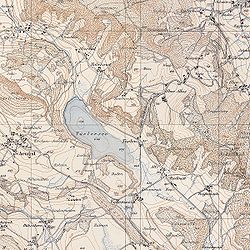
160:Rudolf Leuzinger
142:Canton of Zürich
122:
115:
111:
108:
102:
100:
59:
35:
27:
21:
406:
405:
401:
400:
399:
397:
396:
395:
371:
370:
369:
368:
359:
357:
349:
348:
344:
339:
317:
220:
202:Carte Siegfried
184:Siegfried Atlas
156:Aletsch Glacier
123:
112:
106:
103:
60:
58:
48:
36:
23:
22:
15:
12:
11:
5:
404:
402:
394:
393:
388:
383:
373:
372:
367:
366:
341:
340:
338:
335:
334:
333:
328:
323:
316:
315:External links
313:
268:Jura Mountains
264:French Prealps
245:map historians
194:Siegfriedkarte
140:region in the
125:
124:
39:
37:
30:
24:
14:
13:
10:
9:
6:
4:
3:
2:
403:
392:
389:
387:
384:
382:
379:
378:
376:
356:
352:
346:
343:
336:
332:
329:
327:
324:
322:
319:
318:
314:
312:
310:
305:
303:
299:
294:
291:
288:
283:
279:
277:
273:
270:and southern
269:
265:
261:
260:Swiss plateau
257:
252:
250:
249:Siegfried Map
246:
242:
238:
234:
230:
224:
219:
215:
211:
207:
203:
199:
195:
191:
190:
189:Siegfried Map
185:
181:
177:
173:
165:
161:
157:
153:
152:Siegfried Map
149:
143:
139:
135:
134:Siegfried Map
131:
121:
118:
110:
107:November 2023
99:
96:
92:
89:
85:
82:
78:
75:
71:
68: –
67:
63:
62:Find sources:
56:
52:
46:
45:
40:This article
38:
34:
29:
28:
19:
18:Siegfried Map
358:. Retrieved
354:
345:
306:
295:
292:
284:
280:
253:
248:
201:
193:
188:
187:
183:
179:
171:
169:
151:
133:
113:
104:
94:
87:
80:
73:
61:
49:Please help
44:verification
41:
302:lithography
221: [
210:Switzerland
164:Märjelensee
381:Map series
375:Categories
360:2020-09-08
276:Swiss Alps
256:Dufour Map
206:map series
77:newspapers
337:Citations
192:(German:
138:Türlersee
298:intaglio
287:contours
391:Atlases
154:of the
136:of the
91:scholar
272:Ticino
266:, the
262:, the
216:under
198:French
176:German
93:
86:
79:
72:
64:
241:atlas
225:]
98:JSTOR
84:books
235:and
170:The
70:news
208:of
186:or
53:by
377::
353:.
311:.
278:.
251:.
231:,
223:de
200::
196:;
178::
363:.
174:(
120:)
114:(
109:)
105:(
95:·
88:·
81:·
74:·
47:.
20:)
Text is available under the Creative Commons Attribution-ShareAlike License. Additional terms may apply.