34:
187:
227:
published a recovery plan for the species that designates a critical habitat of approximately 260.6 acres (105.5 ha) within some surrounding areas on
September 24, 2004, the. Due to the limited distribution of the species, specialized habitat uses and the many threats; the Conservation Trust of
232:
habitats and the corridors found between existing populations. The three areas comprising a total of 174 acres (70 ha) of the Sierra
Pandura National Protected Area are the first land purchases of private land that focus on the protection of the rock coqui's natural habitat.
945:
381:
922:
461:
374:
512:
682:
972:
967:
471:
398:
367:
224:
747:
443:
390:
159:
407:
497:
876:
737:
540:
507:
195:
897:
517:
502:
103:
425:
828:
762:
757:
677:
664:
593:
242:
982:
977:
818:
752:
787:
206:). This protected natural area is one of the last habitats of the rare, endemic and endangered Puerto Rican rock frog (
216:
in
Spanish. This small species of frog dwells primarily in crevices and grottos (habitats which are locally known as
153:
Sierra
Pandura rises to an elevation of 1,722 feet (525 m) above sea level at Cerro Santa Elena, located in the
927:
608:
707:
623:
618:
558:
433:
672:
603:
489:
553:
782:
633:
613:
583:
247:
147:
143:
722:
712:
578:
573:
208:
155:
588:
628:
56:
33:
598:
548:
163:
139:
135:
85:
81:
902:
563:
717:
568:
479:
343:
150:
physiological region, a composite body of volcanic origin which bifurcates the mountain ridge.
792:
767:
687:
654:
638:
415:
295:
742:
186:
175:
166:. Other peaks in the mountain range include Cerro de la Pandura, located near the sector of
39:
860:
797:
772:
692:
270:
123:
844:
823:
702:
96:
961:
777:
727:
456:
190:
The endangered rock coqui (female pictured) can only be found on this mountain range.
127:
732:
697:
451:
359:
344:"Conservation Trust of Puerto Rico » Blog Archive » Sierra Pandura ENG"
531:
131:
89:
813:
319:
63:
185:
170:
with an elevation of 1,692 feet (516 m) above sea level, and
178:
for "the little hat") with 1,463 feet (446 m) in elevation.
363:
946:
Puerto Rico
Department of Natural and Environmental Resources
194:
The western portion of Sierra
Pandura is protected by the
911:
890:
869:
853:
837:
806:
663:
647:
539:
530:
488:
470:
442:
424:
406:
397:
95:
77:
72:
62:
52:
47:
21:
923:Parque Nacional de las Cavernas del Río Camuy
912:
375:
8:
146:to the south, Sierra Pandura is part of the
228:Puerto Rico intends to permanently protect
536:
403:
382:
368:
360:
18:
122:, is a mountain range that runs from the
204:Área natural protegida de Sierra Pandura
259:
225:United States Fish and Wildlife Service
212:) also known as the rock coqui or the
200:Sierra Pandura Protected Natural Area
182:Sierra Pandura Protected Natural Area
7:
408:National Estuarine Research Reserves
265:
263:
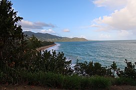
38:Eastern end of Sierra Pandura from
14:
877:La Robleda Natural Protected Area
130:in the southeast in southeastern
134:, between the municipalities of
32:
444:National Wild and Scenic Rivers
973:Protected areas of Puerto Rico
968:Mountain ranges of Puerto Rico
829:Palmas del Mar Tropical Forest
391:Protected areas of Puerto Rico
243:Protected areas of Puerto Rico
196:Puerto Rico Conservation Trust
1:
898:Mata de Plátano Field Station
819:Foreman Conservation Easement
753:Northeast Ecological Corridor
16:Mountain range in Puerto Rico
788:San Juan Ecological Corridor
27:Cuchilla de Pandura, La Pica
807:Conservation Easement Sites
999:
928:Julio Enrique Monagas Park
68:1,722 ft (525 m)
940:
913:
490:National Wildlife Refuges
220:) of the Sierra Pandura.
31:
26:
673:Aguas Buenas Cave System
126:in the northwest to the
870:Protected Natural Areas
748:Mona and Monito Islands
209:Eleutherodactylus cooki
723:Humacao Nature Reserve
713:Cuevas Las Cabachuelas
191:
248:Sierra de Guardarraya
189:
148:San Lorinzo batholith
144:Sierra de Guardarraya
983:Yabucoa, Puerto Rico
978:Maunabo, Puerto Rico
783:San Cristóbal Canyon
142:. Together with the
118:(Pandura Ridge) and
320:"Yabucoa Mountains"
296:"Cerro Santa Elena"
116:Cuchilla de Pandura
914:Parques Nacionales
838:Conservation Zones
738:La Cordillera Reef
733:Inés María Mendoza
718:Hacienda Belvedere
275:Para la Naturaleza
192:
104:Cordillera Central
48:Highest point
955:
954:
936:
935:
891:Research Reserves
793:Tortuguero Lagoon
768:Punta Guaniquilla
655:Bosque del Pueblo
594:Los Tres Picachos
526:
525:
109:
108:
57:Cerro Santa Elena
990:
916:
903:Sierra de Jájome
743:Las Bocas Canyon
683:Caño Martín Peña
537:
513:Laguna Cartagena
472:Wilderness Areas
426:National Forests
404:
384:
377:
370:
361:
354:
353:
351:
350:
340:
334:
333:
331:
330:
316:
310:
309:
307:
306:
292:
286:
285:
283:
282:
271:"Sierra Pandura"
267:
114:, also known as
99:
36:
19:
998:
997:
993:
992:
991:
989:
988:
987:
958:
957:
956:
951:
932:
907:
886:
865:
861:Isla Verde Reef
854:Marine Reserves
849:
833:
802:
798:Tourmaline Reef
773:Puerto Mosquito
758:Planadas-Yeyesa
708:Cueva del Indio
693:Cerro Las Tetas
678:Caja de Muertos
665:Nature Reserves
659:
643:
522:
484:
466:
438:
420:
393:
388:
358:
357:
348:
346:
342:
341:
337:
328:
326:
318:
317:
313:
304:
302:
294:
293:
289:
280:
278:
269:
268:
261:
256:
239:
184:
124:Sierra de Cayey
97:
43:
17:
12:
11:
5:
996:
994:
986:
985:
980:
975:
970:
960:
959:
953:
952:
950:
949:
941:
938:
937:
934:
933:
931:
930:
925:
919:
917:
909:
908:
906:
905:
900:
894:
892:
888:
887:
885:
884:
882:Sierra Pandura
879:
873:
871:
867:
866:
864:
863:
857:
855:
851:
850:
848:
847:
845:Northern Karst
841:
839:
835:
834:
832:
831:
826:
824:Montes Oscuros
821:
816:
810:
808:
804:
803:
801:
800:
795:
790:
785:
780:
775:
770:
765:
763:Punta Cucharas
760:
755:
750:
745:
740:
735:
730:
725:
720:
715:
710:
705:
703:Condado Lagoon
700:
695:
690:
688:Caño Tiburones
685:
680:
675:
669:
667:
661:
660:
658:
657:
651:
649:
645:
644:
642:
641:
636:
631:
626:
621:
616:
611:
606:
601:
596:
591:
586:
581:
576:
571:
566:
561:
556:
551:
545:
543:
534:
528:
527:
524:
523:
521:
520:
515:
510:
505:
500:
494:
492:
486:
485:
483:
482:
476:
474:
468:
467:
465:
464:
462:Río de la Mina
459:
454:
448:
446:
440:
439:
437:
436:
430:
428:
422:
421:
419:
418:
416:Bahía de Jobos
412:
410:
401:
395:
394:
389:
387:
386:
379:
372:
364:
356:
355:
335:
311:
287:
258:
257:
255:
252:
251:
250:
245:
238:
235:
183:
180:
112:Sierra Pandura
107:
106:
101:
93:
92:
79:
75:
74:
70:
69:
66:
60:
59:
54:
50:
49:
45:
44:
37:
29:
28:
24:
23:
22:Sierra Pandura
15:
13:
10:
9:
6:
4:
3:
2:
995:
984:
981:
979:
976:
974:
971:
969:
966:
965:
963:
948:
947:
943:
942:
939:
929:
926:
924:
921:
920:
918:
915:
910:
904:
901:
899:
896:
895:
893:
889:
883:
880:
878:
875:
874:
872:
868:
862:
859:
858:
856:
852:
846:
843:
842:
840:
836:
830:
827:
825:
822:
820:
817:
815:
812:
811:
809:
805:
799:
796:
794:
791:
789:
786:
784:
781:
779:
778:Punta Petrona
776:
774:
771:
769:
766:
764:
761:
759:
756:
754:
751:
749:
746:
744:
741:
739:
736:
734:
731:
729:
728:Joyuda Lagoon
726:
724:
721:
719:
716:
714:
711:
709:
706:
704:
701:
699:
696:
694:
691:
689:
686:
684:
681:
679:
676:
674:
671:
670:
668:
666:
662:
656:
653:
652:
650:
648:Other Forests
646:
640:
637:
635:
632:
630:
627:
625:
622:
620:
617:
615:
612:
610:
609:Nuevo Milenio
607:
605:
602:
600:
597:
595:
592:
590:
587:
585:
582:
580:
577:
575:
572:
570:
567:
565:
562:
560:
557:
555:
552:
550:
547:
546:
544:
542:
541:State Forests
538:
535:
533:
529:
519:
516:
514:
511:
509:
506:
504:
501:
499:
496:
495:
493:
491:
487:
481:
478:
477:
475:
473:
469:
463:
460:
458:
455:
453:
450:
449:
447:
445:
441:
435:
432:
431:
429:
427:
423:
417:
414:
413:
411:
409:
405:
402:
400:
396:
392:
385:
380:
378:
373:
371:
366:
365:
362:
345:
339:
336:
325:
321:
315:
312:
301:
297:
291:
288:
276:
272:
266:
264:
260:
253:
249:
246:
244:
241:
240:
236:
234:
231:
226:
221:
219:
215:
211:
210:
205:
201:
197:
188:
181:
179:
177:
173:
172:El Sombrerito
169:
165:
161:
158:
157:
151:
149:
145:
141:
137:
133:
129:
128:Caribbean Sea
125:
121:
117:
113:
105:
102:
100:
94:
91:
87:
83:
80:
76:
71:
67:
65:
61:
58:
55:
51:
46:
41:
35:
30:
25:
20:
944:
881:
698:Cibuco Swamp
624:San Patricio
532:Commonwealth
347:. Retrieved
338:
327:. Retrieved
323:
314:
303:. Retrieved
299:
290:
279:. Retrieved
277:. 2013-05-08
274:
229:
222:
217:
214:coquí guajón
213:
207:
203:
199:
193:
171:
167:
154:
152:
119:
115:
111:
110:
98:Parent range
604:Monte Choca
457:Río Mameyes
160:Juan Martín
132:Puerto Rico
90:Puerto Rico
962:Categories
814:El Rabanal
634:Toro Negro
559:Cambalache
452:Río Icacos
349:2022-01-25
329:2022-01-25
305:2022-01-25
281:2022-01-25
254:References
218:guajonales
202:(Spanish:
40:Punta Tuna
619:Río Abajo
579:Guajataca
574:Cerrillos
498:Cabo Rojo
434:El Yunque
324:PeakVisor
300:PeakVisor
73:Geography
64:Elevation
589:Guilarte
554:Boquerón
508:Desecheo
237:See also
78:Location
614:Piñones
599:Maricao
584:Guánica
549:Aguirre
518:Vieques
503:Culebra
480:El Toro
399:Federal
198:as the
176:Spanish
168:La Pica
164:Yabucoa
140:Yabucoa
136:Maunabo
120:La Pica
86:Yabucoa
82:Maunabo
564:Carite
230:guajón
156:barrio
629:Susúa
569:Ceiba
639:Vega
223:The
138:and
84:and
53:Peak
162:of
964::
322:.
298:.
273:.
262:^
88:,
383:e
376:t
369:v
352:.
332:.
308:.
284:.
174:(
42:.
Text is available under the Creative Commons Attribution-ShareAlike License. Additional terms may apply.