226:
359:
240:
33:
396:
420:
425:
320:
389:
218:
is included in the Sierra de Gata comarca, even though it is geographically not in the mountainous area of the Sierra de Gata itself.
201:
69:
382:
62:
415:
17:
211:
207:
282:
214:
that includes of 20 municipalities located roughly in the same area as the mountains. The municipality of
312:
230:
153:
185:
225:
189:
294:
173:
136:
109:
38:
358:
165:
124:
366:
161:
117:
239:
409:
365:
This article about a location in the autonomous community of
Extremadura, Spain is a
32:
193:
335:
322:
84:
71:
270:
215:
197:
260:
The most important mountains of Sierra de Gata are (from West to East):
141:
52:
244:
169:
307:
370:
184:
The Sierra de Gata is located in the northwest of the
313:
Most beautiful places in Sierra de Gata (in
Spanish)
135:
130:
116:
105:
100:
61:
51:
46:
25:
243:Sierra de Gata peaks in the winter looming over
390:
8:
397:
383:
200:on the west in the area of the Portuguese
22:
16:For the place in Province of Cáceres, see
229:1,456 m high La Corredera peak seen from
238:
224:
308:Official page for the area (in Spanish)
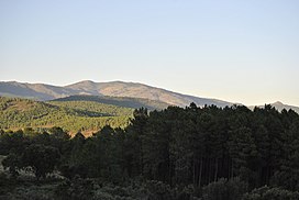
37:View of the Sierra de Gata range from
7:
355:
353:
14:
357:
202:Serra da Malcata Natural Reserve
31:
421:Mountain ranges of Extremadura
1:
369:. You can help Knowledge by
57:1,592 m (5,223 ft)
426:Extremadura geography stubs
442:
352:
222:
15:
30:
18:Sierra de Gata (comarca)
172:. The highest point is
157:
291:La Corredera (1,456 m)
248:
234:
210:is also the name of a
279:Bolla Chica (1,408 m)
267:El Espinazo (1,330 m)
242:
228:
160:) is one of the main
190:autonomous community
332: /
186:province of Cáceres
81: /
288:Arrobuey (1,412 m)
249:
235:
196:. It borders with
188:, which is in the
47:Highest point
378:
377:
253:
252:
147:
146:
110:Iberian Peninsula
433:
399:
392:
385:
361:
354:
347:
346:
344:
343:
342:
337:
336:40.233°N 6.750°W
333:
330:
329:
328:
325:
276:Jañona (1,367 m)
221:
220:
120:
96:
95:
93:
92:
91:
86:
82:
79:
78:
77:
74:
35:
23:
441:
440:
436:
435:
434:
432:
431:
430:
416:Sistema Central
406:
405:
404:
403:
350:
340:
338:
334:
331:
326:
323:
321:
319:
318:
304:
264:Mesas (1,265 m)
258:
182:
166:Sistema Central
162:mountain ranges
125:Sistema Central
118:
89:
87:
83:
80:
75:
72:
70:
68:
67:
42:
21:
12:
11:
5:
439:
437:
429:
428:
423:
418:
408:
407:
402:
401:
394:
387:
379:
376:
375:
362:
341:40.233; -6.750
316:
315:
310:
303:
302:External links
300:
299:
298:
292:
289:
286:
280:
277:
274:
268:
265:
257:
254:
251:
250:
236:
208:Sierra de Gata
181:
178:
150:Sierra de Gata
145:
144:
139:
133:
132:
128:
127:
122:
114:
113:
107:
103:
102:
98:
97:
65:
59:
58:
55:
49:
48:
44:
43:
36:
28:
27:
26:Sierra de Gata
13:
10:
9:
6:
4:
3:
2:
438:
427:
424:
422:
419:
417:
414:
413:
411:
400:
395:
393:
388:
386:
381:
380:
374:
372:
368:
363:
360:
356:
351:
348:
345:
314:
311:
309:
306:
305:
301:
296:
295:Peña Canchera
293:
290:
287:
284:
281:
278:
275:
272:
269:
266:
263:
262:
261:
255:
246:
241:
237:
232:
227:
223:
219:
217:
213:
209:
205:
203:
199:
195:
191:
187:
179:
177:
175:
174:Peña Canchera
171:
167:
163:
159:
158:Sierra e Gata
155:
151:
143:
140:
138:
134:
129:
126:
123:
121:
115:
111:
108:
104:
99:
94:
66:
64:
60:
56:
54:
50:
45:
40:
34:
29:
24:
19:
371:expanding it
364:
349:
317:
259:
206:
183:
154:Extremaduran
149:
148:
137:Type of rock
119:Parent range
85:40.2°N 6.7°W
339: /
194:Extremadura
176:(1,592 m).
88: /
63:Coordinates
410:Categories
90:40.2; -6.7
297:(1,592 m)
285:(1,519 m)
273:(1,492 m)
180:Geography
101:Geography
53:Elevation
216:Moraleja
198:Portugal
106:Location
324:40°14′N
212:comarca
164:in the
142:Granite
131:Geology
112:, Spain
73:40°12′N
327:6°45′W
271:Jálama
231:Huetre
76:6°42′W
283:Bolla
256:Peaks
245:Eljas
170:Spain
39:Acebo
367:stub
192:of
412::
204:.
168:,
156::
398:e
391:t
384:v
373:.
247:.
233:.
152:(
41:.
20:.
Text is available under the Creative Commons Attribution-ShareAlike License. Additional terms may apply.


