208:
220:. The Fuller First Mine was the first quartz location in the basin. In 1890, Archie Campbell installed a revolving Dodge mill on the Fuller First. Over fifty placer claims on the basin's level floor were owned by the Silver-Bow Basin Mining Company, of Boston, while the Eastern Alaska Mining and Milling Company's mill was at the extreme end of the basin. In 1890, the Silver Bow Basin Mining Company properties were transferred to the Nowell Gold Mining Company, which worked the placer deposits until 1902. In 1897, the
42:
26:
122:
257:
49:
224:
incorporated and it purchased over two dozen claims in the basin between the
Perseverance and Ebner mines in order to lode mine their low grade gold ore. The Lervey Basin placer claim was opened in 1899 a mile above Silver Bow Basin. In 1915, it was reported that a 2 miles (3.2 km) tunnel was
203:
is closely connected to development in the basin, as well as having grubstaked the prospectors Harris and Juneau. By the end of the decade, large scale hydraulic mining was in operation. The mines were reached by a 3.5 miles (5.6 km) wagon road that zig-zagged across the hill.
277:. The postglacial lake basin is filled with gravels from several creeks including Gold, Icy, Lurvey, Nugget, as well as Quartz Gulches. The basin ores are principally gold with small amounts of silver, zinc, or lead. Granite rocks are located in the northwestern part of the basin.
215:
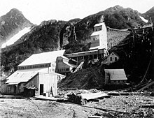
Both quartz and placer mines operated in the basin, but because of climatic conditions, it was impossible to carry on milling operations in the basin itself for more than five or six mouths during the year. The largest of the mines was the
237:
272:
forks into North Lurvey Creek and East Lurvey Creek above the basin. The basin's lake beds are auriferous. Although the creek was filled with ice, there are patches near the basin which were not subjected to
207:
408:
Appletons' guide-book to Alaska and the northwest coast: including the shores of
Washington, British Columbia, southeastern Alaska, the Aleutian and the Seal islands, the Bering and the Arctic coasts
156:. A trail from Juneau leads directly to the mountainside. The basin was the site of the earliest gold discovery in the Juneau area, leading to the establishment of the town called Juneau.
268:, excavated the depression that forms the basin. Subsequently, it was occupied by a lake that was separated from the lower portions of the creek by a solid rock divide.
742:
The
Federal reporter: Cases Argued and Determined in the Circuit Courts of Appeals and Circuit and District Courts of the United States November 1908 – January 1909
229:
and Silver Bow Basin, to connect with a crosscut from the shaft on the thirteenth level. The purpose of the tunnel was to transport mined ore to the mills on the
377:
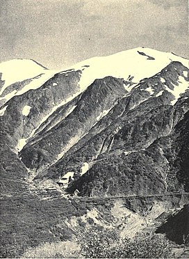
718:
Reports containing the cases determined in all the circuits from the organization of the courts: fully reported with numerous annotations ...
280:
Silver Bow Basin is approximately 3,000 feet (910 m) long and 1,000 feet (300 m) wide, at an altitude of 1,250 feet (380 m).
823:
87:
41:
447:
221:
639:
245:
689:
226:
80:
184:
165:
149:
818:
169:
188:
172:. Another theory is that it was named by a party of Montana miners in honor of their last camp in Montana.
402:
512:"Silver Bow Basin (Nowell; Silver Bow Hydraulic Mine Mine), Juneau District, Juneau Borough, Alaska, USA"
217:
355:
200:
269:
191:. This gold discovery led to the creation of the town called Juneau. Over the next nine years,
164:
There are opposing theories as to who named the basin. One version states that it was named by
764:
740:
536:
443:
230:
591:
561:
406:
325:
439:
432:
692:. Cathedral of the Nativity of the Blessed Virgin Mary. January 16, 2008. Archived from
327:
Reconnaissance of the gold fields of southern Alaska: with some notes on general geology
274:
180:
153:
145:
25:
812:
260:
Map of the Gold Creek area showing the location of the
Perseverance shaft (top right)
241:
196:
121:
125:
152:
in an area north of Icy Gulch, and approximately 1.5 miles (2.4 km) north of
789:
716:
665:
615:
482:
297:
264:
A glacier, which formerly extended to the mouth of Gold Creek and built up the
233:. Total production estimates exceed 50,000 ounces (1,400,000 g) of gold.
693:
102:
89:
256:
211:
Alaska
Perseverance Co. mine and buildings at Silverbow Basin, August 1910
690:"A Brief History of Cathedral of the Nativity of the Blessed Virgin Mary"
593:
Report on population and resources of Alaska at the eleventh census, 1890
192:
511:
265:
141:
481:
DeArmond, R. N.; Association, Gastineau
Channel Centennial (1967).
255:
206:
120:
438:. Bloomington, London: Indiana University Press. p.
745:. Vol. 164. West Publishing Co. 1909. pp. 662–
715:
United States. Courts: Circuit Court of
Appeals (1909).
248:, was created in 1885 for the growing mining community.
487:. Gastineau Channel Centennial Association. p. 40
470:. United States Government Printing Office. p. 2.
299:
Alaska: its southern coast and the Sitkan archipelago
238:
Cathedral of the
Nativity of the Blessed Virgin Mary
468:
The Juneau Gold Belt, Alaska, USGS Bulletin No. 287
195:operations recovered thousands of ounces of gold.
79:
74:
66:
18:
431:
356:"1880 gold discovery creates town called Juneau"
667:Annual report of the Department of the Interior
183:was found in the basin's Gold Creek in 1880 by
596:. Government Printing Office. pp. 48, 233
397:
395:
330:. Government Printing Office. pp. 62, 70–
664:United States. Dept. of the Interior (1915).
585:
583:
581:
378:"Mining operations, Silver Bow Basin, Alaska"
144:located 2.4 miles (3.9 km) northeast of
8:
506:
504:
502:
349:
347:
345:
319:
317:
670:. U.S. Govt. Print. Off., 1849. p. 459
566:. Harrison publishing company. pp. 32–
541:. McGraw-Hill Pub. Co. 1914. pp. 314–
15:
461:
459:
48:
288:
225:being driven through the ridge between
617:United States Congressional serial set
128:of the Silver Bow Basin (center right)
590:United States. Census Office (1893).
7:
411:. D. Appleton and Co. pp. 83–84
380:. University of Washington Libraries
302:. D. Lothrop and Company. p. 93
640:"Alaska Juneau Gold Mining Company"
14:
788:Geological Survey (U.S.) (1947).
560:Harrison, Edward Sanford (1909).
324:Becker, George Ferdinand (1898).
222:Alaska-Juneau Gold Mining Company
296:Scidmore, Eliza Ruhamah (1885).
246:Roman Catholic Diocese of Juneau
47:
40:
24:
538:Engineering and mining journal
1:
824:Landforms of Juneau, Alaska
840:
466:Arthur C. Spencer (1906).
70:1,250 ft (380 m)
148:, USA. It is situated on
35:
23:
430:Wharton, David (1973).
403:Scidmore, Eliza Ruhamah
484:The founding of Juneau
261:
212:
129:
103:58.31111°N 134.34278°W
30:Silver Bow Basin, 1908
769:. 1901. pp. 435–
766:The Colliery engineer
259:
210:
124:
434:The Alaska gold rush
108:58.31111; -134.34278
794:. G.P.O. p. 84
358:. The Juneau Empire
170:Silver Bow, Montana
136:, often written as
99: /
791:Water-supply paper
696:on October 5, 2010
262:
213:
168:after the mine in
130:
819:Valleys of Alaska
644:iath.virginia.edu
354:Chandonnet, Ann.
231:Gastineau Channel
119:
118:
831:
804:
803:
801:
799:
785:
779:
778:
776:
774:
761:
755:
754:
752:
750:
737:
731:
730:
728:
726:
712:
706:
705:
703:
701:
686:
680:
679:
677:
675:
661:
655:
654:
652:
650:
636:
630:
629:
627:
625:
612:
606:
605:
603:
601:
587:
576:
575:
573:
571:
557:
551:
550:
548:
546:
533:
527:
526:
524:
522:
508:
497:
496:
494:
492:
478:
472:
471:
463:
454:
453:
437:
427:
421:
420:
418:
416:
399:
390:
389:
387:
385:
374:
368:
367:
365:
363:
351:
340:
339:
337:
335:
321:
312:
311:
309:
307:
293:
236:A parish of the
134:Silver Bow Basin
114:
113:
111:
110:
109:
104:
100:
97:
96:
95:
92:
55:Silver Bow Basin
51:
50:
44:
28:
19:Silver Bow Basin
16:
839:
838:
834:
833:
832:
830:
829:
828:
809:
808:
807:
797:
795:
787:
786:
782:
772:
770:
763:
762:
758:
748:
746:
739:
738:
734:
724:
722:
714:
713:
709:
699:
697:
688:
687:
683:
673:
671:
663:
662:
658:
648:
646:
638:
637:
633:
623:
621:
614:
613:
609:
599:
597:
589:
588:
579:
569:
567:
559:
558:
554:
544:
542:
535:
534:
530:
520:
518:
510:
509:
500:
490:
488:
480:
479:
475:
465:
464:
457:
450:
429:
428:
424:
414:
412:
401:
400:
393:
383:
381:
376:
375:
371:
361:
359:
353:
352:
343:
333:
331:
323:
322:
315:
305:
303:
295:
294:
290:
286:
254:
178:
162:
138:Silverbow Basin
107:
105:
101:
98:
93:
90:
88:
86:
85:
67:Floor elevation
62:
61:
60:
59:
58:
57:
56:
52:
31:
12:
11:
5:
837:
835:
827:
826:
821:
811:
810:
806:
805:
780:
756:
732:
707:
681:
656:
631:
607:
577:
563:Alaska almanac
552:
528:
498:
473:
455:
448:
422:
391:
369:
341:
313:
287:
285:
282:
253:
250:
201:George E. Pilz
185:Richard Harris
177:
174:
166:Richard Harris
161:
158:
154:Gastineau Peak
146:Juneau, Alaska
117:
116:
83:
77:
76:
72:
71:
68:
64:
63:
54:
53:
46:
45:
39:
38:
37:
36:
33:
32:
29:
21:
20:
13:
10:
9:
6:
4:
3:
2:
836:
825:
822:
820:
817:
816:
814:
793:
792:
784:
781:
768:
767:
760:
757:
744:
743:
736:
733:
720:
719:
711:
708:
695:
691:
685:
682:
669:
668:
660:
657:
645:
641:
635:
632:
619:
618:
611:
608:
595:
594:
586:
584:
582:
578:
565:
564:
556:
553:
540:
539:
532:
529:
517:
513:
507:
505:
503:
499:
486:
485:
477:
474:
469:
462:
460:
456:
451:
449:0-253-10061-5
445:
441:
436:
435:
426:
423:
410:
409:
404:
398:
396:
392:
379:
373:
370:
357:
350:
348:
346:
342:
329:
328:
320:
318:
314:
301:
300:
292:
289:
283:
281:
278:
276:
271:
267:
258:
251:
249:
247:
243:
242:mother church
239:
234:
232:
228:
223:
219:
209:
205:
202:
198:
194:
190:
186:
182:
175:
173:
171:
167:
159:
157:
155:
151:
147:
143:
139:
135:
127:
123:
112:
84:
82:
78:
73:
69:
65:
43:
34:
27:
22:
17:
796:. Retrieved
790:
783:
771:. Retrieved
765:
759:
747:. Retrieved
741:
735:
723:. Retrieved
721:West Pub. Co
717:
710:
698:. Retrieved
694:the original
684:
672:. Retrieved
666:
659:
647:. Retrieved
643:
634:
622:. Retrieved
616:
610:
598:. Retrieved
592:
568:. Retrieved
562:
555:
543:. Retrieved
537:
531:
519:. Retrieved
515:
489:. Retrieved
483:
476:
467:
433:
425:
413:. Retrieved
407:
382:. Retrieved
372:
360:. Retrieved
332:. Retrieved
326:
304:. Retrieved
298:
291:
279:
270:Lurvey Creek
263:
235:
218:Perseverance
214:
179:
163:
137:
133:
131:
126:Geologic map
227:Sheep Creek
106: /
94:134°20′34″W
81:Coordinates
813:Categories
516:mindat.org
284:References
275:glaciation
189:Joe Juneau
150:Gold Creek
91:58°18′40″N
252:Geography
199:engineer
160:Etymology
75:Geography
798:12 March
773:12 March
749:13 March
725:12 March
674:12 March
649:12 March
624:12 March
600:12 March
570:12 March
545:12 March
521:12 March
491:12 March
415:12 March
405:(1893).
384:12 March
362:13 March
334:12 March
306:12 March
266:moraines
193:sluicing
700:June 4,
244:of the
176:History
140:, is a
115:
620:. 1907
446:
181:Placer
142:valley
197:Sitka
800:2011
775:2011
751:2011
727:2011
702:2010
676:2011
651:2011
626:2011
602:2011
572:2011
547:2011
523:2011
493:2011
444:ISBN
417:2011
386:2011
364:2011
336:2011
308:2011
187:and
132:The
815::
642:.
580:^
514:.
501:^
458:^
442:.
394:^
344:^
316:^
240:,
802:.
777:.
753:.
729:.
704:.
678:.
653:.
628:.
604:.
574:.
549:.
525:.
495:.
452:.
440:3
419:.
388:.
366:.
338:.
310:.
Text is available under the Creative Commons Attribution-ShareAlike License. Additional terms may apply.