1399:
809:
55:
43:
239:
702:
745:
105:
355:, Singair Upazila had 65,058 households and a population of 287,451. 62,790 (21.84%) were under 10 years of age. Singair had a literacy rate (age 7 and over) of 46.19%, compared to the national average of 51.8%, and a sex ratio of 1041 females per 1000 males. 26,885 (9.35%) lived in urban areas.
1398:
808:
362:, Singair has a population of 461628. Males constitute 50.47% of the population, and females 49.53%. This Upazila's eighteen up population is 267789. Singair has an average literacy rate of 21.1% (7+ years), and the national average of 32.4% literate.
406:
According to
Banglapedia, Dakkhin Jamsha High School founded in 1969, Basiruddin Foundation High School (Jamsha Union), Baira High School (1949), Charigram S A Khan High School (1948),
418:(1929), Nabagram Multilateral High School (1921), Shahrail High School (1964), Singair Pilot High School (1940), and Singair Pilot Girl's High School are notable secondary schools.
733:
556:
638:
711:
1440:
726:
1469:
1464:
65:
195:
42:
530:
719:
54:
484:
631:
908:
592:
567:
495:
509:
468:
1433:
1065:
661:
624:
249:
1214:
411:
1171:
989:
888:
1459:
1295:
1123:
898:
793:
184:
701:
1426:
1204:
1080:
1037:
916:
676:
437:
432:
398:
129:
117:
415:
845:
427:
407:
359:
352:
320:
33:
1378:
1257:
878:
840:
382:, Jamirta, Saista, and Talibpur. The union parishads are subdivided into 137 mauzas and 241 villages.
1242:
1148:
946:
1267:
1128:
1105:
305:
238:
375:
1275:
1237:
1186:
1075:
1057:
1024:
994:
969:
926:
855:
850:
788:
671:
647:
219:
134:
1305:
1285:
1247:
1199:
1161:
1156:
1138:
1133:
1090:
999:
979:
954:
936:
931:
883:
825:
817:
686:
534:
1410:
1373:
1368:
1363:
1358:
1353:
1348:
1343:
1315:
1229:
1118:
1047:
1009:
959:
921:
870:
860:
835:
460:
207:
1338:
1333:
1328:
1280:
1252:
1219:
1176:
1113:
1085:
1032:
984:
964:
893:
778:
681:
379:
1406:
1323:
1300:
1209:
1194:
1166:
1042:
1014:
830:
770:
750:
371:
223:
122:
1453:
1290:
1070:
1004:
798:
783:
666:
974:
744:
227:
110:
264:
251:
80:
67:
175:
485:"Bangladesh Population and Housing Census 2011 Zila Report – Manikganj"
386:
215:
97:
616:
180:
761:
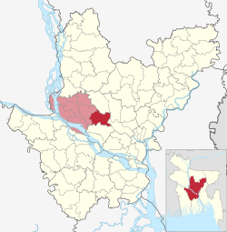
237:
715:
620:
370:
Singair
Upazila is divided into Singair Municipality and 11
378:, Charigram, Singair, Dhalla, Bayra, Chandhar, Baldahara,
277:. It has 65,058 households and total area 221.45 km.
1414:
385:
410:(1967), Jamirta SG Multilateral High School (1921),
1314:
1266:
1228:
1185:
1147:
1104:
1056:
1023:
945:
907:
869:
816:
769:
654:
191:
174:
166:
158:
153:
145:
140:
128:
116:
96:
21:
465:Banglapedia: National Encyclopedia of Bangladesh
1434:
727:
632:
463:, in Sirajul Islam and Ahmed A. Jamal (ed.),
454:
452:
8:
479:
477:
1441:
1427:
734:
720:
712:
639:
625:
617:
403:There are three colleges in the upazila.
18:
600:Secondary and Higher Education Division
448:
190:
173:
152:
139:
95:
60:
51:
39:
510:"Community Tables: Manikganj district"
149:221.45 km (85.50 sq mi)
557:"District Statistics 2011: Manikganj"
165:
157:
144:
127:
115:
7:
1395:
1393:
290:Religions in Singair upazila (2011)
1413:. You can help Knowledge (XXG) by
14:
1397:
807:
743:
700:
103:
53:
41:
564:Bangladesh Bureau of Statistics
496:Bangladesh Bureau of Statistics
242:Savar- Singair Regional Highway
1470:Dhaka Division geography stubs
1465:Upazilas of Manikganj District
1:
531:"Population Census Wing, BBS"
469:Asiatic Society of Bangladesh
47:Kaliganga River, Jamsha Union
412:Talebpur Adarsho High school
16:Upazila in Dhaka, Bangladesh
170:1,300/km (3,400/sq mi)
1486:
1392:
805:
396:
757:
698:
342:
334:
329:
319:
314:
304:
299:
294:
289:
211:
61:
52:
40:
31:
438:Divisions of Bangladesh
433:Districts of Bangladesh
399:Education in Bangladesh
196:Official Map of Singair
1409:location article is a
428:Upazilas of Bangladesh
408:Golaidanga High School
360:1991 Bangladesh census
353:2011 Bangladesh census
246:Singair is located at
243:
416:Joymontop High School
241:
81:23.81528°N 90.13417°E
1149:Narayanganj District
947:Kishoreganj District
167: • Density
1268:Shariatpur District
1106:Munshiganj District
573:on 13 November 2014
467:(Second ed.),
335:Other or not stated
265:23.8167°N 90.1500°E
261: /
222:in the Division of
77: /
1187:Narsingdi District
1058:Manikganj District
1025:Madaripur District
909:Gopalganj District
648:Manikganj District
593:"List of Colleges"
459:MA Ramzan (2012),
244:
220:Manikganj District
159: • Total
146: • Total
86:23.81528; 90.13417
1422:
1421:
1387:
1386:
818:Faridpur District
709:
708:
461:"Singair Upazila"
351:According to the
347:
346:
201:
200:
1477:
1443:
1436:
1429:
1401:
1394:
1316:Tangail District
1230:Rajbari District
871:Gazipur District
811:
749:Upazilas of the
748:
747:
736:
729:
722:
713:
704:
641:
634:
627:
618:
612:
611:
609:
607:
597:
589:
583:
582:
580:
578:
572:
566:. Archived from
561:
553:
547:
546:
544:
542:
533:. Archived from
527:
521:
520:
514:
506:
500:
499:
489:
481:
472:
471:
456:
287:
286:
276:
275:
273:
272:
271:
270:23.8167; 90.1500
266:
262:
259:
258:
257:
254:
213:
109:
107:
106:
92:
91:
89:
88:
87:
82:
78:
75:
74:
73:
70:
57:
45:
19:
1485:
1484:
1480:
1479:
1478:
1476:
1475:
1474:
1460:Singair Upazila
1450:
1449:
1448:
1447:
1390:
1388:
1383:
1310:
1262:
1224:
1181:
1143:
1100:
1052:
1019:
941:
903:
865:
812:
803:
765:
753:
742:
740:
710:
705:
696:
650:
645:
615:
605:
603:
595:
591:
590:
586:
576:
574:
570:
559:
555:
554:
550:
540:
538:
529:
528:
524:
512:
508:
507:
503:
487:
483:
482:
475:
458:
457:
450:
446:
424:
401:
395:
372:union parishads
368:
349:
348:
340:
327:
312:
283:
269:
267:
263:
260:
255:
252:
250:
248:
247:
236:
104:
102:
85:
83:
79:
76:
71:
68:
66:
64:
63:
48:
36:
27:
24:
17:
12:
11:
5:
1483:
1481:
1473:
1472:
1467:
1462:
1452:
1451:
1446:
1445:
1438:
1431:
1423:
1420:
1419:
1407:Dhaka Division
1402:
1385:
1384:
1382:
1381:
1376:
1371:
1366:
1361:
1356:
1351:
1346:
1341:
1336:
1331:
1326:
1320:
1318:
1312:
1311:
1309:
1308:
1303:
1298:
1293:
1288:
1283:
1278:
1272:
1270:
1264:
1263:
1261:
1260:
1255:
1250:
1245:
1240:
1234:
1232:
1226:
1225:
1223:
1222:
1217:
1212:
1207:
1202:
1197:
1191:
1189:
1183:
1182:
1180:
1179:
1174:
1169:
1164:
1159:
1153:
1151:
1145:
1144:
1142:
1141:
1136:
1131:
1126:
1121:
1116:
1110:
1108:
1102:
1101:
1099:
1098:
1093:
1088:
1083:
1078:
1073:
1068:
1062:
1060:
1054:
1053:
1051:
1050:
1045:
1040:
1035:
1029:
1027:
1021:
1020:
1018:
1017:
1012:
1007:
1002:
997:
992:
987:
982:
977:
972:
967:
962:
957:
951:
949:
943:
942:
940:
939:
934:
929:
924:
919:
913:
911:
905:
904:
902:
901:
896:
891:
886:
881:
875:
873:
867:
866:
864:
863:
858:
853:
848:
846:Faridpur Sadar
843:
838:
833:
828:
822:
820:
814:
813:
806:
804:
802:
801:
796:
791:
786:
781:
775:
773:
771:Dhaka District
767:
766:
759:Headquarters:
758:
755:
754:
751:Dhaka Division
741:
739:
738:
731:
724:
716:
707:
706:
699:
697:
695:
694:
689:
684:
679:
674:
669:
664:
658:
656:
655:Upazila/Thana:
652:
651:
646:
644:
643:
636:
629:
621:
614:
613:
584:
548:
522:
501:
473:
447:
445:
442:
441:
440:
435:
430:
423:
420:
394:
391:
367:
366:Administration
364:
345:
344:
341:
338:
336:
332:
331:
328:
325:
323:
317:
316:
313:
310:
308:
302:
301:
298:
296:
292:
291:
285:
284:
282:
279:
235:
232:
199:
198:
193:
189:
188:
178:
172:
171:
168:
164:
163:
160:
156:
155:
151:
150:
147:
143:
142:
138:
137:
132:
126:
125:
120:
114:
113:
100:
94:
93:
59:
58:
50:
49:
46:
38:
37:
32:
29:
28:
25:
22:
15:
13:
10:
9:
6:
4:
3:
2:
1482:
1471:
1468:
1466:
1463:
1461:
1458:
1457:
1455:
1444:
1439:
1437:
1432:
1430:
1425:
1424:
1418:
1416:
1412:
1408:
1403:
1400:
1396:
1391:
1380:
1377:
1375:
1372:
1370:
1367:
1365:
1362:
1360:
1357:
1355:
1352:
1350:
1347:
1345:
1342:
1340:
1337:
1335:
1332:
1330:
1327:
1325:
1322:
1321:
1319:
1317:
1313:
1307:
1304:
1302:
1299:
1297:
1294:
1292:
1289:
1287:
1284:
1282:
1279:
1277:
1274:
1273:
1271:
1269:
1265:
1259:
1256:
1254:
1251:
1249:
1246:
1244:
1241:
1239:
1236:
1235:
1233:
1231:
1227:
1221:
1218:
1216:
1213:
1211:
1208:
1206:
1203:
1201:
1198:
1196:
1193:
1192:
1190:
1188:
1184:
1178:
1175:
1173:
1170:
1168:
1165:
1163:
1160:
1158:
1155:
1154:
1152:
1150:
1146:
1140:
1137:
1135:
1132:
1130:
1127:
1125:
1122:
1120:
1117:
1115:
1112:
1111:
1109:
1107:
1103:
1097:
1094:
1092:
1089:
1087:
1084:
1082:
1079:
1077:
1074:
1072:
1069:
1067:
1064:
1063:
1061:
1059:
1055:
1049:
1046:
1044:
1041:
1039:
1036:
1034:
1031:
1030:
1028:
1026:
1022:
1016:
1013:
1011:
1008:
1006:
1003:
1001:
998:
996:
993:
991:
988:
986:
983:
981:
978:
976:
973:
971:
968:
966:
963:
961:
958:
956:
953:
952:
950:
948:
944:
938:
935:
933:
930:
928:
925:
923:
920:
918:
915:
914:
912:
910:
906:
900:
897:
895:
892:
890:
887:
885:
882:
880:
877:
876:
874:
872:
868:
862:
859:
857:
854:
852:
849:
847:
844:
842:
841:Charbhadrasan
839:
837:
834:
832:
829:
827:
824:
823:
821:
819:
815:
810:
800:
797:
795:
792:
790:
787:
785:
782:
780:
777:
776:
774:
772:
768:
764:
763:
756:
752:
746:
737:
732:
730:
725:
723:
718:
717:
714:
703:
693:
690:
688:
685:
683:
680:
678:
675:
673:
670:
668:
665:
663:
660:
659:
657:
653:
649:
642:
637:
635:
630:
628:
623:
622:
619:
601:
594:
588:
585:
569:
565:
558:
552:
549:
537:on 2005-03-27
536:
532:
526:
523:
518:
511:
505:
502:
497:
493:
486:
480:
478:
474:
470:
466:
462:
455:
453:
449:
443:
439:
436:
434:
431:
429:
426:
425:
421:
419:
417:
413:
409:
404:
400:
392:
390:
388:
383:
381:
377:
373:
365:
363:
361:
356:
354:
337:
333:
324:
322:
318:
309:
307:
303:
297:
293:
288:
280:
278:
274:
240:
233:
231:
229:
225:
221:
217:
209:
205:
197:
194:
186:
182:
179:
177:
169:
161:
148:
136:
133:
131:
124:
121:
119:
112:
101:
99:
90:
62:Coordinates:
56:
44:
35:
30:
20:
1415:expanding it
1404:
1389:
1243:Goalandaghat
1095:
760:
691:
604:. Retrieved
599:
587:
575:. Retrieved
568:the original
563:
551:
541:November 10,
539:. Retrieved
535:the original
525:
516:
504:
491:
464:
405:
402:
384:
369:
357:
350:
281:Demographics
245:
203:
202:
1172:Narayanganj
1129:Sirajdikhan
990:Kishoreganj
268: /
84: /
1454:Categories
1296:Shariatpur
1276:Bhedarganj
1238:Baliakandi
1124:Munshiganj
1076:Harirampur
995:Kuliarchar
970:Hossainpur
927:Kotalipara
856:Nagarkanda
851:Madhukhali
789:Keraniganj
672:Harirampur
517:bbs.gov.bd
492:bbs.gov.bd
444:References
397:See also:
358:As of the
256:90°09′00″E
253:23°49′00″N
228:Bangladesh
154:Population
111:Bangladesh
72:90°08′03″E
69:23°48′55″N
1306:Shakhipur
1286:Gosairhat
1248:Kalukhali
1205:Narsingdi
1200:Monohardi
1162:Sonargaon
1157:Araihazar
1139:Tongibari
1134:Sreenagar
1091:Shivalaya
1081:Manikganj
1066:Daulatpur
1038:Madaripur
1000:Mithamain
980:Karimganj
955:Austagram
937:Tungipara
932:Muksudpur
917:Gopalganj
884:Kaliakair
826:Alfadanga
794:Nawabganj
687:Shivalaya
677:Manikganj
662:Daulatpur
393:Education
380:Joymontop
234:Geography
176:Time zone
135:Manikganj
1374:Sakhipur
1369:Nagarpur
1364:Mirzapur
1359:Dhanbari
1354:Madhupur
1349:Kalihati
1344:Gopalpur
1119:Lohaganj
1048:Shibchar
1010:Pakundia
960:Bajitpur
922:Kashiani
889:Kaliganj
861:Sadarpur
836:Boalmari
422:See also
414:(1973),
387:mahallas
321:Hinduism
295:Religion
214:) is an
212:সিঙ্গাইর
130:District
118:Division
26:সিঙ্গাইর
1379:Tangail
1339:Ghatail
1334:Delduar
1329:Bhuapur
1281:Damudya
1258:Rajbari
1253:Pangsha
1220:Shibpur
1215:Raipura
1177:Rupganj
1114:Gazaria
1096:Singair
1086:Saturia
1033:Kalkini
985:Katiadi
965:Bhairab
899:Sreepur
894:Kapasia
879:Gazipur
779:Dhamrai
692:Singair
682:Saturia
606:25 July
577:14 July
519:. 2011.
339:
326:
311:
300:Percent
216:upazila
208:Bengali
204:Singair
192:Website
162:287,451
98:Country
34:Upazila
23:Singair
1324:Basail
1301:Zajira
1210:Palash
1195:Belabo
1167:Bandar
1043:Rajoir
1015:Tarail
831:Bhanga
602:. 2016
376:Jamsha
315:93.94%
108:
1405:This
1291:Naria
1071:Ghior
1005:Nikli
799:Savar
784:Dohar
762:Dhaka
667:Ghior
596:(XLS)
571:(PDF)
560:(PDF)
513:(PDF)
488:(PDF)
343:0.01%
330:6.05%
306:Islam
224:Dhaka
181:UTC+6
123:Dhaka
1411:stub
975:Itna
608:2017
579:2014
543:2006
141:Area
218:of
185:BST
1456::
598:.
562:.
515:.
494:.
490:.
476:^
451:^
389:.
374::
230:.
226:,
210::
1442:e
1435:t
1428:v
1417:.
735:e
728:t
721:v
640:e
633:t
626:v
610:.
581:.
545:.
498:.
206:(
187:)
183:(
Text is available under the Creative Commons Attribution-ShareAlike License. Additional terms may apply.

