22:
78:
The areas of the two former parishes were 7.8435 km (3.0284 sq mi) (Skelsmergh) 4.22 km (1.63 sq mi) (Scalthwaiterigg), giving an area for the current parish of 12.02635 km (4.64340 sq mi). The southern part of the parish includes the 317 metres
67:
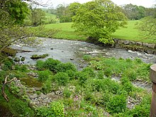
and named for the two previous parishes. Skelsmergh parish ward (north of the river) is represented by five councillors, and
Scalthwaiterigg parish ward (south of the river) by two councillors, a pattern established in 2007.
191:
143:
198:
266:
75:; the 2011 population of the former parish of Scalthwaiterigg is not available, but its 2001 population was 104. (the 2001 population of Skelsmergh was 271).
392:
441:
431:
436:
335:
302:
323:
290:
254:
72:
57:
258:
21:
327:
294:
124:
80:
96:
356:
192:"South Lakeland District (Parishes of Skelsmergh and Scalthwaiterigg) Grouping Order 2007"
131:
53:
41:
163:
425:
37:
92:
64:
49:
26:
407:
394:
223:
116:
108:
45:
120:
100:
48:, England. It was formed on 1 April 2015 by merging the parishes of
240:
Ordnance Survey 1:25,000 map showing the parish and ward boundaries
29:
which forms the boundary between the two wards, the former parishes
112:
20:
71:
The population of the former parish of
Skelsmergh was 303 in the
384:
104:
88:
84:
63:
The parish is divided into two wards, separated by the
295:"Local Area Report – Scalthwaiterigg Parish (16UG062)"
169:. Skelsmergh and Scalthwaiterigg Parish Council. 2016
259:"Local Area Report – Skelsmergh Parish (E04002648)"
144:Listed buildings in Skelsmergh and Scalthwaiterigg
328:"Local Area Report – Skelsmergh Parish (16UG065)"
285:
283:
249:
247:
199:Local Government Boundary Commission for England
229:. Skelsmergh and Scalthwaiterigg Parish Council
8:
217:
215:
186:
184:
224:"Skelsmergh and Scalthwaiterigg Parish"
155:
7:
164:"Chairman's Annual Report 2015/16"
14:
222:South Lakeland District Council.
134:in the parish, all at grade II.
16:Civil parish in Cumbria, England
442:2015 establishments in England
336:Office for National Statistics
303:Office for National Statistics
267:Office for National Statistics
34:Skelsmergh and Scalthwaiterigg
1:
127:all pass through the parish.
83:, which is classified as a
458:
73:2011 United Kingdom census
432:Civil parishes in Cumbria
437:South Lakeland District
385:Parish Council website
361:www.hill-bagging.co.uk
30:
79:(1,040 ft) hill
56:, which had shared a
24:
404: /
31:
449:
419:
418:
416:
415:
414:
409:
405:
402:
401:
400:
397:
372:
371:
369:
367:
353:
347:
346:
344:
342:
320:
314:
313:
311:
309:
287:
278:
277:
275:
273:
251:
242:
238:
236:
234:
228:
219:
210:
209:
207:
205:
196:
188:
179:
178:
176:
174:
168:
160:
132:listed buildings
130:There are eight
457:
456:
452:
451:
450:
448:
447:
446:
422:
421:
412:
410:
406:
403:
398:
395:
393:
391:
390:
381:
376:
375:
365:
363:
355:
354:
350:
340:
338:
322:
321:
317:
307:
305:
289:
288:
281:
271:
269:
253:
252:
245:
232:
230:
226:
221:
220:
213:
203:
201:
194:
190:
189:
182:
172:
170:
166:
162:
161:
157:
152:
140:
111:from Kendal to
54:Scalthwaiterigg
17:
12:
11:
5:
455:
453:
445:
444:
439:
434:
424:
423:
408:54.35°N 2.72°W
388:
387:
380:
379:External links
377:
374:
373:
357:"Benson Knott"
348:
315:
279:
243:
211:
180:
154:
153:
151:
148:
147:
146:
139:
136:
119:footpath from
58:parish council
42:South Lakeland
15:
13:
10:
9:
6:
4:
3:
2:
454:
443:
440:
438:
435:
433:
430:
429:
427:
420:
417:
386:
383:
382:
378:
362:
358:
352:
349:
337:
333:
329:
325:
319:
316:
304:
300:
296:
292:
286:
284:
280:
268:
264:
260:
256:
250:
248:
244:
241:
225:
218:
216:
212:
200:
193:
187:
185:
181:
165:
159:
156:
149:
145:
142:
141:
137:
135:
133:
128:
126:
122:
118:
114:
110:
106:
102:
98:
94:
90:
86:
82:
76:
74:
69:
66:
61:
59:
55:
51:
47:
43:
39:
35:
28:
23:
19:
413:54.35; -2.72
389:
364:. Retrieved
360:
351:
339:. Retrieved
331:
318:
306:. Retrieved
298:
270:. Retrieved
262:
239:
231:. Retrieved
202:. Retrieved
171:. Retrieved
158:
129:
81:Benson Knott
77:
70:
62:
60:since 2007.
38:civil parish
33:
32:
18:
411: /
426:Categories
366:18 October
341:18 October
308:18 October
272:18 October
233:18 October
204:18 October
173:18 October
150:References
115:, and the
65:River Mint
50:Skelsmergh
44:district,
27:River Mint
324:UK Census
291:UK Census
255:UK Census
117:Dales Way
109:A685 road
326:(2001).
293:(2001).
257:(2011).
138:See also
396:54°21′N
125:Bowness
46:Cumbria
399:2°43′W
121:Ilkley
107:, the
101:Kendal
95:. The
91:and a
332:Nomis
299:Nomis
263:Nomis
227:(PDF)
195:(PDF)
167:(PDF)
113:Tebay
99:from
36:is a
368:2021
343:2021
310:2021
274:2021
235:2021
206:2021
175:2021
105:Shap
93:Clem
89:TuMP
87:, a
85:HuMP
52:and
25:The
123:to
103:to
40:in
428::
359:.
334:.
330:.
301:.
297:.
282:^
265:.
261:.
246:^
214:^
197:.
183:^
97:A6
370:.
345:.
312:.
276:.
237:.
208:.
177:.
Text is available under the Creative Commons Attribution-ShareAlike License. Additional terms may apply.