34:
212:
295:
Nilsen, Håkon (4 September 2020). "Mandag var det ett år siden helikopterulykken: Verdig avduking av minnesmerke på Skoddevarrefjellet" [One Year
Commemoration of Helicopter Crash on Monday: Dignified Unveiling of Memorial on Skoddevarre].
322:
139:. The mountain has several peaks, the tallest of which is located in the east, reaching 435.4 metres (1,428 ft) above sea level. The
157:
runs north of the mountain between the settlements. The west wall at
Skoddevarre is 200 metres (660 ft) high and is used for
145:
states that the highest peak is 434 metres (1,424 ft) and is located in the north. Nearby settlements include the village of
66:
317:
141:
59:
189:
177:
180:
that killed six people. A memorial is located at the crash site, which was built a year after the accident.
116:
252:
170:
154:
128:
277:
311:
158:
166:
150:
81:
68:
162:
132:
124:
146:
136:
49:
33:
300:(in Norwegian Bokmål). Vol. 11, no. 33. pp. 16–17.
234:
102:
97:
58:
48:
43:
21:
176:On 31 August 2019, the mountain was the site of
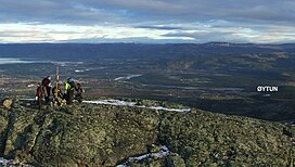
38:View from the peak of Skoddevarre towards Alta.
228:
226:
8:
207:
205:
149:northwest of the mountain and the town of
18:
276:Rostad, Ida Louise (4 September 2019).
201:
7:
280:[Helicopter Crash in Alta].
233:Askheim, Svein (26 January 2023) .
14:
32:
219:. Norwegian Mapping Authority.
169:. The "Gubben" formation is a
1:
239:Great Norwegian Encyclopedia
142:Great Norwegian Encyclopedia
54:435.4 m (1,428 ft)
323:Mountains under 1000 metres
173:in the middle of the rock.
339:
278:"Helikopterulykken i Alta"
190:2019 Alta helicopter crash
161:. The bedrock consists of
31:
26:
253:"Skoddevarre Vestveggen"
284:(in Norwegian Bokmål).
153:to the northeast. The
120:
106:Alta, Finnmark, Norway
318:Mountains of Finnmark
82:69.93583°N 23.14583°E
78: /
178:a helicopter crash
87:69.93583; 23.14583
44:Highest point
16:Mountain in Norway
155:European route E6
129:Alta Municipality
110:
109:
330:
302:
301:
292:
286:
285:
273:
267:
266:
264:
263:
257:
249:
243:
242:
230:
221:
220:
209:
93:
92:
90:
89:
88:
83:
79:
76:
75:
74:
71:
36:
19:
338:
337:
333:
332:
331:
329:
328:
327:
308:
307:
306:
305:
294:
293:
289:
275:
274:
270:
261:
259:
255:
251:
250:
246:
232:
231:
224:
211:
210:
203:
198:
186:
86:
84:
80:
77:
72:
69:
67:
65:
64:
39:
17:
12:
11:
5:
336:
334:
326:
325:
320:
310:
309:
304:
303:
298:Kronstadposten
287:
268:
258:(in Norwegian)
244:
222:
213:"Skoađđovárri"
200:
199:
197:
194:
193:
192:
185:
182:
108:
107:
104:
100:
99:
95:
94:
62:
56:
55:
52:
46:
45:
41:
40:
37:
29:
28:
24:
23:
15:
13:
10:
9:
6:
4:
3:
2:
335:
324:
321:
319:
316:
315:
313:
299:
291:
288:
283:
279:
272:
269:
254:
248:
245:
240:
236:
235:"Skoddevarre"
229:
227:
223:
218:
217:norgeskart.no
214:
208:
206:
202:
195:
191:
188:
187:
183:
181:
179:
174:
172:
168:
164:
160:
159:rock climbing
156:
152:
148:
144:
143:
138:
134:
130:
126:
122:
118:
117:Northern Sami
114:
105:
101:
96:
91:
63:
61:
57:
53:
51:
47:
42:
35:
30:
25:
20:
297:
290:
281:
271:
260:. Retrieved
247:
238:
216:
175:
140:
121:Skoađđovárri
112:
111:
27:Skoađđovárri
167:greenschist
113:Skoddevarre
85: /
60:Coordinates
22:Skoddevarre
312:Categories
262:2019-09-01
196:References
163:sandstone
98:Geography
73:23°8′45″E
70:69°56′9″N
50:Elevation
184:See also
171:pinnacle
135:county,
133:Finnmark
125:mountain
103:Location
147:Kvenvik
123:) is a
137:Norway
256:(PDF)
165:and
151:Alta
282:NRK
131:in
127:in
314::
237:.
225:^
215:.
204:^
119::
265:.
241:.
115:(
Text is available under the Creative Commons Attribution-ShareAlike License. Additional terms may apply.