205:
29:
250:
305:. Due to the city of Skopje, the Skopje Basin has always been an area with a high number of migrations, immigration, and emigration of the population. After World War I, migrations to the Skopje Basin from various parts of Macedonia, as well as from territories of the former Yugoslavia, reached their peak, and they continue to this day.
236:
of the Vardar River, known as Skopje Plain. It ranges in elevation from 225 metres (738 ft) as the lowest point to 2,540 meters (8,330 ft) as the highest point. The average elevation is 281 meters (922 ft), with the city of Skopje located at 245 meters (804 ft). The surface area
313:
The geographical position, terrain, climate, and soil in the Skopje Basin are highly favourable for agriculture and livestock farming. Crop cultivation is particularly developed in the bordering area of the alluvial plain along the course of the Vardar River. The most common cereal crops include
204:
326:. Large areas are dedicated to the cultivation of vegetables, industrial crops (animal feed), horticulture, and early vegetable production (under greenhouses and plastic tunnels), as well as fruit growing and viticulture. The most cultivated vegetables and horticultural crops include
28:
370:, and fodder oats are also cultivated. Fruit cultivation is mainly found in the hilly areas at the foot of the surrounding mountains in the southern, eastern, and northern parts of the basin. The cultivated fruits include
358:, and Dračevo), lettuce, carrots, potatoes, beans, and peas. The onions from Dračevo are particularly renowned in the markets and are humorously referred to as "Dračevska ligna" due to their size. Industrial crops such as
232:
Gorge in the south. The basin covers an area of 1,924 square kilometres (743 sq mi) and extends in a northwest–southeast direction. The central part of the basin is occupied by the spacious
237:
of the Skopje Plain is 26,100 hectares (64,000 acres). The entire river and water network within the basin belongs to the catchmen area of the Vardar River, i.e. of the
257:
The Skopje Basin represents the most populous and densely populated part of
Macedonia. It is inhabited by 571,040 residents, the majority of whom are
224:. It is surrounded by high mountains from all sides. It is part of the composite valley of the Vardar River, which enters the basin through the
473:
422:, is also located in this area. The entire Skopje Basin in the west-southwest and northeast direction is connected by highways and also by a
426:
line. Such excellent transportation connectivity and accessibility can be attributed to two main factors: the presence of the capital city,
495:
505:
281:. The largest portion of the basin is occupied by the city of Skopje. Ethnographic regions and areas within the Skopje Basin include
83:
500:
419:
76:
411:
258:
402:
The Skopje Basin is the most important and developed transportation area in North
Macedonia. The two pan-European
415:
212:
Skopje Basin is a spacious basin located in the northern part of
Macedonia. It represents a deep and sunken
221:
169:
177:
282:
213:
141:
302:
157:
133:
121:
430:, and the strategic geographical position and terrain configuration, which naturally connects the
290:
181:
161:
469:
294:
286:
165:
225:
335:
249:
145:
59:
278:
233:
489:
266:
435:
173:
379:
355:
238:
217:
192:
in the south. The administrative and population centre of the Skopje Basin is
98:
85:
262:
351:
331:
298:
274:
189:
153:
423:
407:
403:
387:
367:
359:
347:
34:
418:, intersect and connect in the basin. The largest Macedonian airport,
253:
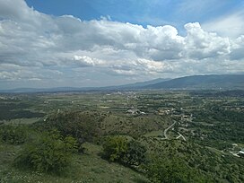
View of the Skopje Basin and the Vardar River from the village of Taor
33:
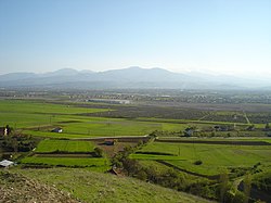
View of the Skopje Basin from the northwest, from the entrance of the
431:
427:
371:
363:
327:
319:
193:
149:
69:
391:
375:
339:
315:
270:
248:
203:
185:
148:. It represents the second largest valley along the course of the
383:
343:
323:
229:
468:(in Macedonian). Vol. 2. Скопје: МАНУ. p. 1369.
152:
river. The Skopje Valley is formed by the mountains of
220:
and is fully integrated into the composition of the
75:
65:
55:
50:
42:
21:
459:
457:
455:
453:
451:
228:Gorge in the northwest and exits through the
8:
208:View of the Skopje Basin from Ajvatovski Rid
245:Population and ethnographic characteristics
18:
330:(the famous variety "Skopski jabučar"),
447:
172:(Gjurište) in the east and northeast,
7:
261:(64.39%), with smaller numbers of
196:, the capital of North Macedonia.
14:
27:
1:
346:(in the village of Dračevo),
420:Alexander the Great Airport
522:
496:Valleys of North Macedonia
506:Skopje Statistical Region
464:Андоновски, Томе (2009).
137:
125:
26:
466:Македонска енциклопедија
140:) is one of the largest
16:Basin in North Macedonia
309:Agriculture and economy
254:
209:
252:
207:
200:Geographical features
188:, i.e. the massif of
176:in the southeast and
99:42.00000°N 21.43333°E
434:Valley to the north
350:(in the villages of
342:, young onions, and
222:Vardar Tectonic Zone
170:Gradiščanska Planina
501:Geography of Skopje
95: /
255:
210:
104:42.00000; 21.43333
66:Population centers
475:978-608-203-023-4
166:Skopska Crna Gora
115:
114:
513:
480:
479:
461:
139:
127:
110:
109:
107:
106:
105:
100:
96:
93:
92:
91:
88:
31:
19:
521:
520:
516:
515:
514:
512:
511:
510:
486:
485:
484:
483:
476:
463:
462:
449:
444:
400:
311:
283:Skopska Blatija
247:
202:
146:North Macedonia
126:Скопска Котлина
103:
101:
97:
94:
89:
86:
84:
82:
81:
60:North Macedonia
43:Floor elevation
38:
17:
12:
11:
5:
519:
517:
509:
508:
503:
498:
488:
487:
482:
481:
474:
446:
445:
443:
440:
399:
396:
310:
307:
303:Skopski Derven
246:
243:
234:alluvial plain
201:
198:
168:in the north,
113:
112:
79:
73:
72:
67:
63:
62:
57:
53:
52:
48:
47:
44:
40:
39:
32:
24:
23:
15:
13:
10:
9:
6:
4:
3:
2:
518:
507:
504:
502:
499:
497:
494:
493:
491:
477:
471:
467:
460:
458:
456:
454:
452:
448:
441:
439:
437:
433:
429:
425:
421:
417:
413:
409:
405:
397:
395:
393:
389:
385:
381:
377:
373:
369:
365:
361:
357:
353:
349:
345:
341:
337:
336:green peppers
333:
329:
325:
321:
317:
308:
306:
304:
300:
296:
292:
288:
284:
280:
276:
272:
268:
264:
260:
251:
244:
242:
240:
235:
231:
227:
223:
219:
215:
206:
199:
197:
195:
191:
190:Mokra Planina
187:
183:
179:
175:
171:
167:
164:in the west,
163:
159:
155:
151:
147:
143:
135:
131:
123:
119:
108:
80:
78:
74:
71:
68:
64:
61:
58:
54:
49:
45:
41:
36:
30:
25:
20:
465:
401:
380:strawberries
312:
256:
211:
160:(Matka) and
138:Скопско Поле
130:Skopje Plain
129:
118:Skopje Basin
117:
116:
22:Skopje Basin
410:corridors,
259:Macedonians
218:fault lines
102: /
77:Coordinates
490:Categories
442:References
356:Zlokukjani
265:(23.11%),
239:Aegean Sea
216:along the
214:depression
134:Macedonian
122:Macedonian
46:250 m
398:Transport
295:Crna Gora
291:Torbešija
263:Albanians
182:Karadžica
174:Golešnica
162:Suva Gora
90:21°26′0″E
51:Geography
438:region.
388:apricots
372:cherries
352:Bardovci
328:tomatoes
287:Karšijak
275:Bosniaks
87:42°0′0″N
56:Location
424:railway
408:railway
404:highway
392:peaches
368:alfalfa
360:tobacco
348:cabbage
332:peppers
111:
35:Lepenec
472:
436:Morava
432:Vardar
428:Skopje
390:, and
376:apples
364:clover
340:onions
322:, and
320:barley
301:, and
277:, and
226:Derven
194:Skopje
158:Ivanje
150:Vardar
142:basins
70:Skopje
384:plums
344:leeks
316:wheat
299:Žeden
279:Turks
271:Serbs
186:Vodno
178:Kitka
154:Žeden
128:) or
37:Gorge
470:ISBN
414:and
412:VIII
406:and
324:oats
267:Roma
230:Taor
184:and
338:),
144:in
492::
450:^
394:.
386:,
382:,
378:,
374:,
366:,
362:,
354:,
318:,
297:,
293:,
289:,
285:,
273:,
269:,
241:.
180:,
156:,
136::
124::
478:.
416:X
334:(
132:(
120:(
Text is available under the Creative Commons Attribution-ShareAlike License. Additional terms may apply.