356:
73:
43:
29:
80:
50:
214:
empties into Snag Lake via Grassy Creek. Water from Snag Lake continues to flow through the porous lava field that led to the lake's creation eventually making its way into
441:
397:
311:
416:
325:
421:
211:
207:
72:
127:
431:
390:
42:
261:
383:
191:
105:
426:
235:
436:
363:
109:
215:
355:
288:
Clynne, Michael A.; Champion, Duane E.; Trimble, Deborah A.; Hendley, James W., II; Stauffer, Peter H.,
305:
367:
159:
410:
257:
291:
How Old is "Cinder Cone"?–Solving a
Mystery in Lassen Volcanic Park, California
28:
195:
113:
142:
129:
289:
210:
at an elevation of 6,050 ft (1,840 m). Water from the nearby
187:
371:
173:
169:
158:
119:
101:
21:
120:
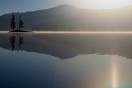
206:The large Snag Lake is located to the south of
226:Snag Lake is accessible by hiking trail only.
16:Lake in the state of California, United States
391:
326:"Snag Lake, USGS PROSPECT PEAK (CA) Topo Map"
8:
310:: CS1 maint: multiple names: authors list (
398:
384:
18:
442:Lassen County, California geography stubs
278:Lassen Volcanic National Park map, 2007.
247:
208:Cinder Cone and the Fantastic Lava Beds
417:Lakes of Lassen Volcanic National Park
303:
274:
272:
270:
190:located in the north eastern part of
7:
352:
350:
253:
251:
422:Lakes of Lassen County, California
14:
294:, United States Geological Survey
79:
49:
354:
78:
71:
48:
41:
27:
172:
1:
192:Lassen Volcanic National Park
106:Lassen Volcanic National Park
100:
92:Show map of the United States
432:Lakes of Northern California
370:. You can help Knowledge by
177:6,050 ft (1,840 m)
236:List of lakes in California
458:
349:
364:Lassen County, California
35:
26:
366:-related article is a
143:40.51389°N 121.31167°W
62:Show map of California
148:40.51389; -121.31167
427:Lakes of California
139: /
437:Lava dammed lakes
379:
378:
198:, United States.
181:
180:
174:Surface elevation
449:
400:
393:
386:
358:
351:
341:
340:
338:
337:
322:
316:
315:
309:
301:
300:
299:
285:
279:
276:
265:
255:
154:
153:
151:
150:
149:
144:
140:
137:
136:
135:
132:
122:
93:
82:
81:
75:
63:
52:
51:
45:
31:
19:
457:
456:
452:
451:
450:
448:
447:
446:
407:
406:
405:
404:
347:
345:
344:
335:
333:
332:. TopoQuest.com
324:
323:
319:
302:
297:
295:
287:
286:
282:
277:
268:
256:
249:
244:
232:
224:
204:
162: countries
147:
145:
141:
138:
133:
130:
128:
126:
125:
97:
96:
95:
94:
91:
90:
89:
88:
87:
83:
66:
65:
64:
61:
60:
59:
58:
57:
53:
17:
12:
11:
5:
455:
453:
445:
444:
439:
434:
429:
424:
419:
409:
408:
403:
402:
395:
388:
380:
377:
376:
359:
343:
342:
330:USGS Quad maps
317:
280:
266:
260:elevation for
246:
245:
243:
240:
239:
238:
231:
228:
223:
220:
212:Horseshoe Lake
203:
200:
179:
178:
175:
171:
170:
167:
166:
163:
156:
155:
123:
117:
116:
114:California, US
103:
99:
98:
85:
84:
77:
76:
70:
69:
68:
67:
55:
54:
47:
46:
40:
39:
38:
37:
36:
33:
32:
24:
23:
15:
13:
10:
9:
6:
4:
3:
2:
454:
443:
440:
438:
435:
433:
430:
428:
425:
423:
420:
418:
415:
414:
412:
401:
396:
394:
389:
387:
382:
381:
375:
373:
369:
365:
360:
357:
353:
348:
331:
327:
321:
318:
313:
307:
293:
292:
284:
281:
275:
273:
271:
267:
263:
259:
254:
252:
248:
241:
237:
234:
233:
229:
227:
221:
219:
217:
213:
209:
201:
199:
197:
193:
189:
185:
176:
168:
165:United States
164:
161:
157:
152:
124:
118:
115:
111:
110:Lassen County
107:
104:
74:
44:
34:
30:
25:
20:
372:expanding it
361:
346:
334:. Retrieved
329:
320:
296:, retrieved
290:
283:
264:coordinates.
258:Google Earth
225:
205:
183:
182:
202:Description
146: /
134:121°18′42″W
121:Coordinates
411:Categories
336:2008-07-05
298:2013-03-28
242:References
216:Butte Lake
196:California
131:40°30′50″N
184:Snag Lake
86:Snag Lake
56:Snag Lake
22:Snag Lake
306:citation
230:See also
102:Location
222:Access
362:This
186:is a
160:Basin
368:stub
312:link
262:GNIS
188:lake
194:in
413::
328:.
308:}}
304:{{
269:^
250:^
218:.
112:,
108:,
399:e
392:t
385:v
374:.
339:.
314:)
Text is available under the Creative Commons Attribution-ShareAlike License. Additional terms may apply.