277:
304:
292:
56:
40:
484:
423:
63:
404:
276:
303:
216:
is located approximately 5 miles (8.0 kilometers) east of
Perrine Bridge along the canyon. The canyon continues through Glenns Ferry and south of Boise, making it longer than 50 miles.
529:
568:
468:
291:
228:
and others founded the Magic Valley's first successful agricultural operations on the Snake River Canyon floor. The canyon's value as a farming area diminished after
553:
563:
558:
340:
251:
approximately 15,000 years ago. However, as of 2000, geologists believe that while the canyon was shaped by the flood, its basic structure predated it.
270:
On
September 16, 2016, stuntman Eddie Braun successfully jumped the canyon using technology similar to that used by Evel Knievel 42 years previously.
522:
55:
461:
548:
408:
200:
to the north. The canyon ranges up to 500 feet (150 meters) deep and 0.25 miles (0.40 kilometers) wide, and runs for just over 50 miles.
515:
131:
454:
375:
362:
267:
rocket. The dirt ramp built for that jump is still there and remains a tourist attraction (42°35'49.5"N 114°25'22.3"W).
124:
20:
232:
projects made agriculture practical in the surrounding areas in the early 20th century. Today the canyon floor is a
491:
193:
111:
430:
24:
39:
205:
499:
438:
244:
248:
326:
283:
213:
201:
542:
225:
209:
197:
264:
260:
185:
16:
Large canyon formed by the Snake River in the Magic Valley region of southern Idaho
181:
243:
In the past it was generally believed the Snake River Canyon was created by a
229:
146:
133:
483:
422:
365:, Cascades Volcano Observatory, January 22, 2003. Accessed August 18, 2008.
403:
259:
The canyon is well known as the site of an unsuccessful 1974 attempt by
233:
177:
376:"Stuntman Eddie Braun makes the jump across the Snake River Canyon"
495:
434:
189:
297:
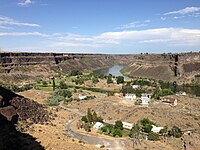
Looking west down the Snake River Canyon from the
Perrine Bridge
237:
503:
442:
204:
crosses the canyon immediately north of the city of
163:
123:
104:
96:
88:
83:
32:
309:View up the Snake River Gorge above Shoshone Falls
62:
341:"Anatomy of a Canyon: Dissecting the Panorama"
212:crosses the canyon to the east of Twin Falls.
523:
462:
329:, Magic Valley website. Retrieved June, 2014.
8:
282:View west down the Snake River Canyon from
530:
516:
469:
455:
363:"Lake Bonneville and the Bonneville Flood"
236:attraction and features several parks and
29:
19:For other canyons with similar names, see
569:Twin Falls County, Idaho geography stubs
319:
272:
192:, forming part of the boundary between
75:Location of Snake River Canyon in Idaho
554:Landforms of Twin Falls County, Idaho
7:
564:Jerome County, Idaho geography stubs
480:
478:
419:
417:
502:. You can help Knowledge (XXG) by
441:. You can help Knowledge (XXG) by
14:
559:Landforms of Jerome County, Idaho
482:
421:
402:
302:
290:
275:
61:
54:
38:
382:. Sinclair Broadcast Group, Inc
247:caused by water released from
1:
498:state location article is a
437:state location article is a
21:Snake River Canyon (Wyoming)
549:Canyons and gorges of Idaho
585:
477:
416:
409:Snake River Canyon (Idaho)
69:Snake River Canyon (Idaho)
33:Snake River Canyon (Idaho)
18:
263:to jump across it in the
224:In the late 19th century
49:
44:Snake River Canyon, Idaho
37:
411:at Wikimedia Commons
25:Hells Canyon (Idaho)
188:region of southern
143: /
174:Snake River Canyon
147:42.600°N 114.417°W
511:
510:
492:Twin Falls County
450:
449:
407:Media related to
343:. MagicValley.com
245:cataclysmic flood
196:to the south and
194:Twin Falls County
171:
170:
576:
532:
525:
518:
486:
479:
471:
464:
457:
425:
418:
406:
392:
391:
389:
387:
372:
366:
359:
353:
352:
350:
348:
339:Dunlap, Tetona.
336:
330:
327:"River of Stone"
324:
306:
294:
279:
158:
157:
155:
154:
153:
152:42.600; -114.417
148:
144:
141:
140:
139:
136:
65:
64:
58:
42:
30:
584:
583:
579:
578:
577:
575:
574:
573:
539:
538:
537:
536:
476:
475:
414:
400:
395:
385:
383:
374:
373:
369:
360:
356:
346:
344:
338:
337:
333:
325:
321:
317:
310:
307:
298:
295:
286:
280:
257:
249:Lake Bonneville
222:
151:
149:
145:
142:
137:
134:
132:
130:
129:
119:
79:
78:
77:
76:
73:
72:
71:
70:
66:
45:
28:
17:
12:
11:
5:
582:
580:
572:
571:
566:
561:
556:
551:
541:
540:
535:
534:
527:
520:
512:
509:
508:
487:
474:
473:
466:
459:
451:
448:
447:
426:
399:
398:External links
396:
394:
393:
367:
361:Topinka, Lyn.
354:
331:
318:
316:
313:
312:
311:
308:
301:
299:
296:
289:
287:
284:Shoshone Falls
281:
274:
256:
253:
221:
218:
214:Shoshone Falls
202:Perrine Bridge
180:formed by the
169:
168:
165:
161:
160:
127:
121:
120:
118:
117:
114:
108:
106:
102:
101:
98:
94:
93:
90:
86:
85:
81:
80:
74:
68:
67:
60:
59:
53:
52:
51:
50:
47:
46:
43:
35:
34:
15:
13:
10:
9:
6:
4:
3:
2:
581:
570:
567:
565:
562:
560:
557:
555:
552:
550:
547:
546:
544:
533:
528:
526:
521:
519:
514:
513:
507:
505:
501:
497:
493:
488:
485:
481:
472:
467:
465:
460:
458:
453:
452:
446:
444:
440:
436:
432:
431:Jerome County
427:
424:
420:
415:
412:
410:
405:
397:
381:
377:
371:
368:
364:
358:
355:
342:
335:
332:
328:
323:
320:
314:
305:
300:
293:
288:
285:
278:
273:
271:
268:
266:
262:
254:
252:
250:
246:
241:
239:
235:
231:
227:
226:I. B. Perrine
219:
217:
215:
211:
210:Hansen Bridge
207:
203:
199:
198:Jerome County
195:
191:
187:
183:
179:
175:
166:
162:
156:
128:
126:
122:
115:
113:
110:
109:
107:
103:
99:
95:
92:United States
91:
87:
82:
57:
48:
41:
36:
31:
26:
22:
504:expanding it
489:
443:expanding it
428:
413:
401:
386:16 September
384:. Retrieved
379:
370:
357:
345:. Retrieved
334:
322:
269:
265:Skycycle X-2
261:Evel Knievel
258:
242:
238:golf courses
223:
186:Magic Valley
173:
172:
182:Snake River
167:Snake River
150: /
125:Coordinates
543:Categories
315:References
255:Local fame
230:irrigation
206:Twin Falls
112:Twin Falls
380:kboi2.com
84:Geography
138:114°25′W
347:May 14,
234:tourist
220:History
184:in the
159:
135:42°36′N
89:Country
178:canyon
116:Jerome
105:County
496:Idaho
490:This
435:Idaho
429:This
190:Idaho
176:is a
164:River
100:Idaho
97:State
500:stub
439:stub
388:2016
349:2015
23:and
545::
494:,
433:,
378:.
240:.
208:;
531:e
524:t
517:v
506:.
470:e
463:t
456:v
445:.
390:.
351:.
27:.
Text is available under the Creative Commons Attribution-ShareAlike License. Additional terms may apply.