417:
384:. War broke out between Ngāti Pāoa and the Kawerau hapū. By the early 19th century, Kawerau-descended hapū held exclusive land rights to the Mahurangi, while fishing rights were shared between these hapū and the Marutūāhu tribes. By the early 19th Century, the Mahurangi Harbour was primarily settled by Ngāti Rongo and their related hapū Ngāti Kā and Ngāti Raupō, all of whom kept close ties to Ngāti Manuhiri, while Marutūahu tribes frequented the coast during the summertime.
33:
444:. Snell settled at the beach, where his family farmed for generations. Scottish immigrant Alexander Algie and wife Mina, née Deerness, bought the land to the south at Martins Bay, where his brother Samuel settled in 1867. The Algie family established a boarding house on the beach in the late 1890s, which operated until 1941.
552:. There were 1,380 households, comprising 1,656 males and 1,746 females, giving a sex ratio of 0.95 males per female. The median age was 47.9 years (compared with 37.4 years nationally), with 606 people (17.8%) aged under 15 years, 438 (12.9%) aged 15 to 29, 1,374 (40.4%) aged 30 to 64, and 984 (28.9%) aged 65 or older.
688:
contributing primary school catering for years 1-6. It opened in 2009. The school is intended to grow to about 500 students. The roll was 394 students in August 2024. Horizon School, formerly
Mahurangi Christian School, is a coeducational full primary (years 1-8) school with a roll of 244 students as
432:
made the first purchases of the
Mahurangi and Omaha blocks on 13 April 1841. While some iwi and hapū with customary interests had been engaged, such as Ngāti Paoa; Ngāti Rongo, Ngāti Raupō and Ngāti Manuhiri were not a part of this transaction, and it took the Crown until the 1850s to finalise a deal
584:
Of those at least 15 years old, 489 (17.5%) people had a bachelor's or higher degree, and 537 (19.2%) people had no formal qualifications. The median income was $ 28,500, compared with $ 31,800 nationally. 399 people (14.3%) earned over $ 70,000 compared to 17.2% nationally. The employment status of
594:
463:
The first block of shops in Snells Beach was constructed in 1982. The commercial and light industrial area of Snells Beach led to the community becoming the service centre for the wider
Mahurangi Peninsula, and the second largest commercial centre in the
468:
areas. During the 2010s, the area transitioned away from being primarily a holiday town to a permanently settled satellite town of
Warkworth. In 2012, the Snells Beach library was marked for closure, leaving many residents bewildered and angry.
455:
immigrants to the area. By the early 20th century, Snells Beach was becoming a popular spot for holidaymakers, and in the 1930s, the area became better connected to the
Auckland roading network, when a metal road was constructed along the
395:
and related northern tribes attacked the
Mahurangi area settlements in retaliation for past losses, leading to the Mahurangi area being depopulated. Ngāti Rongo, Ngāti Raupō and Ngāti Mahuhiri sought refuge with different tribes in
1035:
671:
The Brick Bay
Sculpture Trail – an outdoor gallery showcasing contemporary sculpture amongst native trees, palms, birdlife and green pastures – is located at the western entrance of Snells Beach. Snells Beach contains the
287:
are present on the shallow tidal ecosystem at Snells Beach. The seagrass protects Snells Beach from intense wave action and is an important source of food for protected native wildlife that lives and visits the shoreline.
1480:
1473:
1466:
404:. Ngāti Rongo, Ngāti Raupō and Ngāti Mahuhiri returned to the area by the late 1830s or early 1840s. By this period, many of the Kawerau hapū had developed associations with
361:(Kawau Bay), an important shark fishery. Archaeological middens and terraces have been discovered in the areas adjacent to the north and south headlands of Snells Beach.
923:
1919:
477:
Snells Beach covers 3.83 km (1.48 sq mi) and had an estimated population of 3,810 as of June 2023, with a population density of 995 people per km.
870:
990:
Tino
Rangatiratanga me te Kāwanatanga: The Report on Stage 2 of the Te Paparahi o Te Raki Inquiry. Waitangi Tribunal Report 2023 Wai 1040 Part I Volume 1
436:
The area was originally known as Long Beach to early
European settlers. It was bought in 1854 by Cornish miner James Snell, who had initially settled at
416:
1098:
1834:
1774:
1924:
1653:
949:
577:
Although some people chose not to answer the census's question about religious affiliation, 51.5% had no religion, 38.1% were
Christian, 0.4% had
1350:
1321:
50:
1264:
1216:
1004:
1157:
1067:
1638:
1239:
585:
those at least 15 was that 1,137 (40.6%) people were employed full-time, 444 (15.9%) were part-time, and 72 (2.6%) were unemployed.
709:
1914:
1522:
989:
927:
1829:
1183:
1839:
1633:
1281:
1814:
849:
405:
400:. Ngāti Rongo returned to the Mahurangi area in 1836, under the leadership of Te Hēmara Tauhia, focusing settlement at
1794:
1779:
1819:
1401:
644:
facilities, and overnight parking for motorhomes. The adjacent Goodalls Reserve hosts a community centre, library,
1844:
1577:
1490:
451:
at Snells Beach, extracting seven tons during low tide. Further digs took place in 1907, predominantly by recent
381:
317:
32:
244:, 8 km (5.0 mi) to the west, which is linked by 8 buses a day and also Mahu City Express twice a day.
1851:
1753:
200:
1433:
1422:
1305:
1929:
1892:
1804:
1789:
1784:
1743:
1376:
773:
755:
737:
549:
545:
541:
1326:
1612:
1602:
777:
759:
741:
429:
269:
241:
1824:
1582:
1458:
774:"Subnational population estimates (urban rural), by age and sex, at 30 June 1996-2023 (2023 boundaries)"
401:
273:
322:
1809:
1448:
614:
568:
136:
1362:
756:"Subnational population estimates (TA, SA2), by age and sex, at 30 June 1996-2023 (2023 boundaries)"
738:"Subnational population estimates (RC, SA2), by age and sex, at 30 June 1996-2023 (2023 boundaries)"
1698:
1693:
1678:
799:
685:
457:
301:
The wider Mahurangi area has been settled since at least the 13th century. One of the first known
257:
229:
1879:
1758:
1572:
1542:
601:
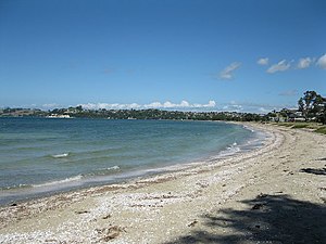
The 2.5 kilometre long tidal sandy beach, which attracts a variety of shorebirds, is popular for
425:
115:
1723:
1628:
1158:
Cultural Impact Assessment for Proposed Foster Crescent Plan Change and Residential Subdivision
896:
1728:
1673:
1260:
1235:
1190:
1000:
996:
665:
578:
261:
1874:
1042:
564:
397:
284:
159:
408:, and the Mahurangi area was contested between Kawerau, Ngāti Whātua and Marutūāhu tribes.
373:
1799:
1733:
1703:
1683:
1337:
673:
661:
452:
441:
217:
95:
560:
365:
1856:
1713:
1688:
1663:
1648:
1587:
1547:
606:
313:
141:
816:
593:
581:, 0.4% were Hindu, 0.2% were Muslim, 0.7% were Buddhist and 1.5% had other religions.
1908:
1748:
1738:
1532:
307:
1668:
1643:
1537:
653:
602:
437:
377:
369:
352:
330:
265:
237:
221:
1527:
556:
574:
The percentage of people born overseas was 25.4, compared with 27.1% nationally.
1884:
1718:
1658:
1567:
1562:
1498:
610:
571:, and 1.9% other ethnicities. People may identify with more than one ethnicity.
388:
225:
105:
85:
1068:
Foster Crescent, Snells Beach - Proposed Subdivision: Archaeological Assessment
1708:
1607:
1517:
392:
376:, sought to control the shark fishery located on the Mahurangi coast, between
338:
277:
841:
640:
The Mahurangi Shopping Centre includes cafés, retail stores, public toilets,
320:
are known to have visited the area, and descendants of captain Manaia of the
65:
52:
657:
634:
618:
448:
334:
1597:
1557:
1552:
1494:
1099:
Warkworth North Structure Plan and Plan Change: Archaeological Assessment
817:"Luxury Commuting On eCoaches. Round-Trip Bus From Auckland to Warkworth"
626:
465:
1232:
Rodney Coast to Coast: the Story of the Rodney County Council 1976-1989
1131:
630:
494:
329:
Mahurangi peoples primarily focused settlement along the shores of the
253:
1512:
1257:
It Takes a Village: a Guide to Matakana and Its Surrounding Districts
649:
622:
660:, sports fields, dog exercise area, and walking tracks. Nearby is a
1036:
Historic Heritage Assessment Report: Draft Warkworth Structure Plan
645:
641:
592:
447:
In 1904, J. Clayden and J. Parkinson discovered a large amount of
415:
348:
233:
337:
based on available seasonal resources. Snells Beach and adjacent
1462:
268:. It is located 8 kilometres (5.0 mi) east of the town of
302:
1453:
1324:. Statistics New Zealand. March 2020. Snells Beach (111700).
926:(Report). Manuhiri Kaitiaki Charitable Trust. Archived from
489:
950:
33-43 McKinney Road, Warkworth: Archaeological Assessment
732:
730:
1338:
Warkworth Information Centre – Snells Beach / Algies Bay
1396:
1394:
326:
waka are known to have intermarried with Ngāi Tāhuhu.
1867:
1767:
1621:
1505:
1134:. Snells Beach Ratepayers and Residents Association
924:
Cultural Impact Assessment for Hall Farm Orewa West
199:
191:
183:
178:
170:
165:
155:
150:
129:
121:
111:
101:
91:
81:
23:
548:, and an increase of 678 people (24.9%) since the
1377:"$ 8 million for new Snells Beach Primary School"
1151:
1149:
1092:
1090:
1088:
689:at August 2024.. The school is state integrated.
351:to the north and south, which looked out towards
1034:Brassey, Robert; Walker, Megan (November 2018).
1029:
1027:
1025:
1023:
1061:
1059:
871:"Comparing seagrass meadows across New Zealand"
800:"Warkworth Kowhai Coast Northern Bus Timetable"
676:’s regional television broadcaster: Family TV.
1316:
1314:
1259:. Massey University Press. pp. 136, 162.
629:, a waterfront café, public toilets, showers,
544:, an increase of 474 people (16.2%) since the
540:Snells Beach had a population of 3,405 at the
1474:
228:. It is situated on the eastern coast of the
8:
1322:"Statistical area 1 dataset for 2018 Census"
1306:Cost cuts threaten two libraries - NZ Herald
1163:(Report). Manuhiri Kaitiaki Charitable Trust
480:
305:to have settled in the area is Ngāi Tāhuhu.
1282:LAND USE & SUBDIVISION RESOURCE CONSENT
984:
982:
980:
978:
976:
974:
972:
970:
356:
342:
1481:
1467:
1459:
943:
941:
939:
937:
479:
20:
1379:. New Zealand Government. 6 December 2006
1125:
1123:
1121:
1119:
1097:Cameron, Ellen; Phear, Sarah (May 2019).
948:Apfel, Aaron; Farley, Glen (March 2021).
621:reserve features footpaths, playgrounds,
1835:Warkworth Radio Astronomical Observatory
1775:Cape Rodney-Okakari Point Marine Reserve
1215:sfn error: no target: CITEREFStone2001 (
1184:The Crown, Maori and Mahurangi 1840-1881
216:is a small coastal town in the north of
1920:Populated places in the Auckland Region
1654:Challenger Island / Little Kawau Island
1327:2018 Census place summary: Snells Beach
1280:Brooke, Gemma-Rose (16 November 2021).
698:
198:
177:
164:
149:
128:
80:
45:
41:
29:
1423:Education Counts: Snells Beach Primary
1234:. Times Media Group Ltd. p. 121.
704:
702:
1210:
1132:"Snells Beach History and Background"
1104:(Report). Clough & Associates Ltd
1073:(Report). Clough & Associates Ltd
955:(Report). Clough & Associates Ltd
897:"Celebrating Snells Beach's seagrass"
272:, and adjacent to the settlements of
190:
182:
169:
154:
120:
110:
100:
90:
18:Place in Auckland Region, New Zealand
7:
1361:(1). 26 January 2009. Archived from
1404:. New Zealand Ministry of Education
420:Aerial view of Snells Beach in 1957
174:3.83 km (1.48 sq mi)
1639:Beehive Island / Taungamaro Island
156: • Territorial Authority
14:
1893:Rodney District Council (defunct)
1287:(Report). The Planning Collective
1066:Judge, Charlotte (October 2017).
922:McKenzie, Fiona (November 2013).
842:"Place name detail: Snells Beach"
633:, and free overnight parking for
1434:Education Counts: Horizon School
555:Ethnicities were 90.7% European/
440:after first working at mines in
31:
1830:Warkworth & District Museum
1523:Baddeleys Beach-Campbells Beach
1402:"New Zealand Schools Directory"
1351:"New school heads to the beach"
236:faces east across Kawau Bay to
1925:Beaches of the Auckland Region
387:In the early 1820s during the
37:Snells Beach from northern end
1:
1454:Snells Beach Official Website
1355:Education Gazette New Zealand
1156:McKenzie, Fiona (July 2018).
424:Following the signing of the
347:) were protected by headland
1182:Rigby, Barry (August 1998).
850:New Zealand Geographic Board
771:(territorial authorities);
333:, moving between different
1946:
1768:Facilities and attractions
684:Snells Beach Primary is a
664:, two motels, and several
1815:Tāwharanui Marine Reserve
1449:New Zealand Tourism Guide
1255:Jacobs, Lauraine (2021).
609:, swimming, fishing, and
533:
507:—
195:990/km (2,600/sq mi)
46:
42:
30:
1852:Wenderholm Regional Park
1820:Tāwharanui Regional Park
1489:Warkworth Subdivision -
1230:Bioletti, Harry (1992).
710:"ArcGIS Web Application"
589:Features and attractions
1915:Rodney Local Board Area
1805:Scandrett Regional Park
1790:Mahurangi Regional Park
1785:Leigh Marine Laboratory
1340:Retrieved December 2011
1308:Retrieved December 2012
714:statsnz.maps.arcgis.com
597:Welcome to Snells Beach
579:Māori religious beliefs
542:2018 New Zealand census
778:Statistics New Zealand
760:Statistics New Zealand
742:Statistics New Zealand
598:
421:
382:Whangaparāoa Peninsula
357:
343:
240:. The nearest town is
66:36.42222°S 174.72750°E
1825:Te Muri Regional Park
846:New Zealand Gazetteer
753:(regional councils);
596:
481:Historical population
419:
264:and Kawau Bay of the
125:Warkworth subdivision
1810:Smelting House ruins
1744:Tāwharanui Peninsula
930:on 27 December 2023.
805:. 30 September 2018.
192: • Density
137:Kaipara ki Mahurangi
71:-36.42222; 174.72750
1840:30m Radio Telescope
1699:Moturekareka Island
1694:Motuketekete Island
1679:Mahurangi Peninsula
1622:Geographic features
901:Snells Conservation
482:
458:Mahurangi Peninsula
412:European settlement
258:Mahurangi Peninsula
252:Snells Beach is an
230:Mahurangi Peninsula
62: /
1880:Rodney Local Board
1759:Whangateau Harbour
666:bed and breakfasts
599:
426:Treaty of Waitangi
422:
364:By the mid-1700s,
323:Māhuhu-ki-te-rangi
184: • Total
171: • Total
116:Rodney Local Board
1902:
1901:
1729:Takangaroa Island
1674:Mahurangi Harbour
1266:978-0-9951431-0-4
1191:Waitangi Tribunal
1006:978-1-86956-365-3
997:Waitangi Tribunal
821:Mahu City Express
538:
537:
262:Mahurangi Harbour
232:and its namesake
211:
210:
1937:
1875:Auckland Council
1780:Holy Name Church
1506:Populated places
1483:
1476:
1469:
1460:
1436:
1431:
1425:
1420:
1414:
1413:
1411:
1409:
1398:
1389:
1388:
1386:
1384:
1373:
1367:
1366:
1347:
1341:
1335:
1329:
1325:
1318:
1309:
1303:
1297:
1296:
1294:
1292:
1286:
1277:
1271:
1270:
1252:
1246:
1245:
1227:
1221:
1220:
1208:
1202:
1201:
1199:
1197:
1188:
1179:
1173:
1172:
1170:
1168:
1162:
1153:
1144:
1143:
1141:
1139:
1127:
1114:
1113:
1111:
1109:
1103:
1094:
1083:
1082:
1080:
1078:
1072:
1063:
1054:
1053:
1051:
1049:
1043:Auckland Council
1040:
1031:
1018:
1017:
1015:
1013:
994:
986:
965:
964:
962:
960:
954:
945:
932:
931:
919:
913:
912:
910:
908:
893:
887:
886:
884:
882:
867:
861:
860:
858:
856:
838:
832:
831:
829:
827:
813:
807:
806:
804:
796:
790:
788:
786:
784:
770:
768:
766:
752:
750:
748:
734:
725:
724:
722:
720:
706:
496:
491:
483:
368:tribes from the
360:
346:
285:seagrass meadows
160:Auckland Council
77:
76:
74:
73:
72:
67:
63:
60:
59:
58:
55:
35:
21:
1945:
1944:
1940:
1939:
1938:
1936:
1935:
1934:
1905:
1904:
1903:
1898:
1863:
1845:Radio Telescope
1800:Pumphouse ruins
1763:
1734:Te Haupa Island
1724:Tāhekeroa River
1704:Motutara Island
1684:Mahurangi River
1629:Arapārera River
1617:
1501:
1487:
1445:
1440:
1439:
1432:
1428:
1421:
1417:
1407:
1405:
1400:
1399:
1392:
1382:
1380:
1375:
1374:
1370:
1349:
1348:
1344:
1336:
1332:
1320:
1319:
1312:
1304:
1300:
1290:
1288:
1284:
1279:
1278:
1274:
1267:
1254:
1253:
1249:
1242:
1229:
1228:
1224:
1214:
1213:, pp. 188.
1209:
1205:
1195:
1193:
1186:
1181:
1180:
1176:
1166:
1164:
1160:
1155:
1154:
1147:
1137:
1135:
1129:
1128:
1117:
1107:
1105:
1101:
1096:
1095:
1086:
1076:
1074:
1070:
1065:
1064:
1057:
1047:
1045:
1038:
1033:
1032:
1021:
1011:
1009:
1007:
992:
988:
987:
968:
958:
956:
952:
947:
946:
935:
921:
920:
916:
906:
904:
895:
894:
890:
880:
878:
869:
868:
864:
854:
852:
840:
839:
835:
825:
823:
815:
814:
810:
802:
798:
797:
793:
782:
780:
772:
764:
762:
754:
746:
744:
736:
735:
728:
718:
716:
708:
707:
700:
695:
682:
674:Rodney District
607:paddle boarding
591:
565:Pacific peoples
475:
442:South Australia
414:
299:
294:
256:located on the
250:
218:Auckland Region
207:
146:
96:Auckland Region
70:
68:
64:
61:
56:
53:
51:
49:
48:
38:
26:
19:
12:
11:
5:
1943:
1941:
1933:
1932:
1930:Matakana Coast
1927:
1922:
1917:
1907:
1906:
1900:
1899:
1897:
1896:
1889:
1888:
1887:
1882:
1871:
1869:
1865:
1864:
1862:
1861:
1860:
1859:
1857:Couldrey House
1849:
1848:
1847:
1842:
1832:
1827:
1822:
1817:
1812:
1807:
1802:
1797:
1792:
1787:
1782:
1777:
1771:
1769:
1765:
1764:
1762:
1761:
1756:
1751:
1746:
1741:
1736:
1731:
1726:
1721:
1716:
1711:
1706:
1701:
1696:
1691:
1689:Matakana River
1686:
1681:
1676:
1671:
1666:
1661:
1656:
1651:
1649:Casnell Island
1646:
1641:
1636:
1634:Archway Island
1631:
1625:
1623:
1619:
1618:
1616:
1615:
1610:
1605:
1600:
1595:
1590:
1588:Scotts Landing
1585:
1580:
1575:
1570:
1565:
1560:
1555:
1550:
1548:Mahurangi West
1545:
1540:
1535:
1530:
1525:
1520:
1515:
1509:
1507:
1503:
1502:
1488:
1486:
1485:
1478:
1471:
1463:
1457:
1456:
1451:
1444:
1443:External links
1441:
1438:
1437:
1426:
1415:
1390:
1368:
1365:on 4 May 2012.
1342:
1330:
1310:
1298:
1272:
1265:
1247:
1240:
1222:
1203:
1174:
1145:
1130:Waters, Judy.
1115:
1084:
1055:
1019:
1005:
966:
933:
914:
903:. 3 March 2023
888:
877:. 1 March 2007
862:
833:
808:
791:
726:
697:
696:
694:
691:
681:
678:
662:petrol station
590:
587:
536:
535:
531:
530:
527:
524:
520:
519:
516:
513:
509:
508:
505:
502:
498:
497:
492:
487:
474:
471:
433:these tribes.
413:
410:
318:migratory waka
298:
295:
293:
290:
260:, between the
249:
246:
209:
208:
205:
203:
197:
196:
193:
189:
188:
185:
181:
180:
176:
175:
172:
168:
167:
163:
162:
157:
153:
152:
148:
147:
145:
144:
142:Te Tai Tokerau
139:
133:
131:
127:
126:
123:
119:
118:
113:
109:
108:
103:
99:
98:
93:
89:
88:
83:
79:
78:
44:
43:
40:
39:
36:
28:
27:
24:
17:
13:
10:
9:
6:
4:
3:
2:
1942:
1931:
1928:
1926:
1923:
1921:
1918:
1916:
1913:
1912:
1910:
1895:
1894:
1890:
1886:
1883:
1881:
1878:
1877:
1876:
1873:
1872:
1870:
1866:
1858:
1855:
1854:
1853:
1850:
1846:
1843:
1841:
1838:
1837:
1836:
1833:
1831:
1828:
1826:
1823:
1821:
1818:
1816:
1813:
1811:
1808:
1806:
1803:
1801:
1798:
1796:
1795:Mansion House
1793:
1791:
1788:
1786:
1783:
1781:
1778:
1776:
1773:
1772:
1770:
1766:
1760:
1757:
1755:
1754:Waiwera River
1752:
1750:
1749:Mathesons Bay
1747:
1745:
1742:
1740:
1739:Te Kapa River
1737:
1735:
1732:
1730:
1727:
1725:
1722:
1720:
1717:
1715:
1712:
1710:
1707:
1705:
1702:
1700:
1697:
1695:
1692:
1690:
1687:
1685:
1682:
1680:
1677:
1675:
1672:
1670:
1667:
1665:
1662:
1660:
1657:
1655:
1652:
1650:
1647:
1645:
1642:
1640:
1637:
1635:
1632:
1630:
1627:
1626:
1624:
1620:
1614:
1611:
1609:
1606:
1604:
1601:
1599:
1596:
1594:
1591:
1589:
1586:
1584:
1581:
1579:
1576:
1574:
1571:
1569:
1566:
1564:
1561:
1559:
1556:
1554:
1551:
1549:
1546:
1544:
1541:
1539:
1536:
1534:
1533:Kaipara Flats
1531:
1529:
1526:
1524:
1521:
1519:
1516:
1514:
1511:
1510:
1508:
1504:
1500:
1496:
1492:
1484:
1479:
1477:
1472:
1470:
1465:
1464:
1461:
1455:
1452:
1450:
1447:
1446:
1442:
1435:
1430:
1427:
1424:
1419:
1416:
1403:
1397:
1395:
1391:
1378:
1372:
1369:
1364:
1360:
1356:
1352:
1346:
1343:
1339:
1334:
1331:
1328:
1323:
1317:
1315:
1311:
1307:
1302:
1299:
1283:
1276:
1273:
1268:
1262:
1258:
1251:
1248:
1243:
1241:0-473-01296-0
1237:
1233:
1226:
1223:
1218:
1212:
1207:
1204:
1192:
1185:
1178:
1175:
1159:
1152:
1150:
1146:
1133:
1126:
1124:
1122:
1120:
1116:
1100:
1093:
1091:
1089:
1085:
1069:
1062:
1060:
1056:
1044:
1037:
1030:
1028:
1026:
1024:
1020:
1008:
1002:
998:
991:
985:
983:
981:
979:
977:
975:
973:
971:
967:
951:
944:
942:
940:
938:
934:
929:
925:
918:
915:
902:
898:
892:
889:
876:
872:
866:
863:
851:
847:
843:
837:
834:
822:
818:
812:
809:
801:
795:
792:
789:(urban areas)
779:
775:
761:
757:
743:
739:
733:
731:
727:
715:
711:
705:
703:
699:
692:
690:
687:
686:coeducational
679:
677:
675:
669:
667:
663:
659:
655:
651:
647:
643:
638:
636:
632:
628:
624:
620:
616:
612:
608:
604:
595:
588:
586:
582:
580:
575:
572:
570:
566:
562:
558:
553:
551:
547:
543:
532:
528:
525:
522:
521:
517:
514:
511:
510:
506:
503:
500:
499:
493:
488:
485:
484:
478:
472:
470:
467:
461:
459:
454:
450:
445:
443:
439:
434:
431:
427:
418:
411:
409:
407:
403:
399:
394:
390:
385:
383:
379:
375:
372:, especially
371:
367:
362:
359:
354:
350:
345:
340:
336:
332:
327:
325:
324:
319:
316:
315:
310:
309:
304:
297:Māori history
296:
291:
289:
286:
281:
279:
275:
271:
267:
263:
259:
255:
247:
245:
243:
239:
235:
231:
227:
223:
219:
215:
204:
202:
194:
186:
173:
161:
158:
143:
140:
138:
135:
134:
132:
124:
117:
114:
107:
104:
97:
94:
87:
84:
75:
47:Coordinates:
34:
22:
16:
1891:
1669:Kawau Island
1644:Brazier Rock
1593:Snells Beach
1592:
1578:Rainbows End
1538:Kawau Island
1429:
1418:
1408:17 September
1406:. Retrieved
1381:. Retrieved
1371:
1363:the original
1358:
1354:
1345:
1333:
1301:
1289:. Retrieved
1275:
1256:
1250:
1231:
1225:
1206:
1194:. Retrieved
1177:
1165:. Retrieved
1136:. Retrieved
1106:. Retrieved
1075:. Retrieved
1046:. Retrieved
1010:. Retrieved
957:. Retrieved
928:the original
917:
905:. Retrieved
900:
891:
879:. Retrieved
874:
865:
853:. Retrieved
845:
836:
824:. Retrieved
820:
811:
794:
781:. Retrieved
763:. Retrieved
745:. Retrieved
717:. Retrieved
713:
683:
670:
654:kindergarten
646:bowling club
639:
623:picnic areas
603:kite surfing
600:
583:
576:
573:
554:
539:
476:
473:Demographics
462:
446:
438:Kawau Island
435:
423:
406:Ngāti Whātua
386:
378:Kawau Island
370:Hauraki Gulf
363:
353:Kawau Island
331:Hauraki Gulf
328:
321:
312:
306:
300:
282:
266:Hauraki Gulf
251:
238:Kawau Island
222:North Island
214:Snells Beach
213:
212:
25:Snells Beach
15:
1885:Rodney ward
1719:Puhoi River
1714:Ōmaha River
1664:Hōteo River
1659:Dome Forest
1568:Point Wells
1499:New Zealand
1012:19 December
650:tennis club
625:, a public
611:dog walking
550:2006 census
546:2013 census
389:Musket Wars
358:Moanauriuri
344:Horahorawai
226:New Zealand
201:Postcode(s)
130:Electorates
122:Subdivision
112:Local board
106:Rodney ward
86:New Zealand
69: /
57:174°43′39″E
1909:Categories
1868:Government
1709:Omaha Cove
1608:Whangateau
1518:Algies Bay
1383:5 February
1291:16 January
1211:Stone 2001
1189:(Report).
1167:16 January
1138:16 January
1108:15 January
1077:16 January
1048:15 January
1041:(Report).
995:(Report).
959:15 January
855:15 January
826:2 November
783:25 October
765:25 October
747:25 October
693:References
658:skate park
635:motorhomes
631:boat ramps
615:pohutukawa
464:Warkworth/
374:Ngāti Pāoa
339:Algies Bay
283:Important
278:Algies Bay
179:Population
151:Government
54:36°25′20″S
1613:Woodcocks
1603:Warkworth
1528:Big Ōmaha
680:Education
619:esplanade
453:Dalmatian
449:kauri gum
430:the Crown
428:in 1840,
398:Northland
366:Marutūāhu
270:Warkworth
248:Geography
242:Warkworth
1598:Ti Point
1583:Sandspit
1563:Pōhuehue
1553:Matakana
1495:Auckland
999:. 2023.
627:barbecue
559:, 10.7%
534:Source:
466:Matakana
380:and the
308:Te Arawa
274:Sandspit
617:-lined
567:, 3.3%
563:, 5.0%
495:±% p.a.
402:Te Muri
393:Ngāpuhi
292:History
254:isthmus
220:in the
82:Country
1513:Ahuroa
1491:Rodney
1263:
1238:
1196:4 July
1003:
907:31 May
881:31 May
719:22 May
613:. The
557:Pākehā
529:+3.04%
518:+1.04%
335:kāinga
314:Tainui
92:Region
1573:Puhoi
1558:Ōmaha
1543:Leigh
1285:(PDF)
1187:(PDF)
1161:(PDF)
1102:(PDF)
1071:(PDF)
1039:(PDF)
993:(PDF)
953:(PDF)
803:(PDF)
569:Asian
561:Māori
526:3,405
515:2,931
504:2,727
234:beach
187:3,810
1410:2024
1385:2009
1293:2024
1261:ISBN
1236:ISBN
1217:help
1198:2023
1169:2024
1140:2024
1110:2024
1079:2024
1050:2024
1014:2023
1001:ISBN
961:2024
909:2023
883:2023
875:NIWA
857:2024
828:2021
785:2023
767:2023
749:2023
721:2022
642:Wifi
523:2018
512:2013
501:2006
490:Pop.
486:Year
355:and
311:and
276:and
206:0920
166:Area
102:Ward
303:iwi
224:of
1911::
1497:,
1493:,
1393:^
1359:88
1357:.
1353:.
1313:^
1148:^
1118:^
1087:^
1058:^
1022:^
969:^
936:^
899:.
873:.
848:.
844:.
819:.
776:.
758:.
740:.
729:^
712:.
701:^
668:.
656:,
652:,
648:,
637:.
605:,
460:.
391:,
349:pā
280:.
1482:e
1475:t
1468:v
1412:.
1387:.
1295:.
1269:.
1244:.
1219:)
1200:.
1171:.
1142:.
1112:.
1081:.
1052:.
1016:.
963:.
911:.
885:.
859:.
830:.
787:.
769:.
751:.
723:.
341:(
Text is available under the Creative Commons Attribution-ShareAlike License. Additional terms may apply.