583:
42:
61:
68:
352:. It extends west into Izaak Walton Bay on the St. Marys River (upstream from Sault Ste. Marie) and east as far as the Little Rapids Channel of the river (downstream from Sault Ste. Marie). The southeastern portion of the township, about 43% of the township's total territory, comprises
363:, the township has a total area of 67.9 square miles (175.9 km), of which 50.1 square miles (129.8 km) is land and 17.8 square miles (46.1 km), or 26.20%, is water.
521:
1080:
698:
648:
92:
465:
643:
248:
514:
275:
378:
341:
41:
285:
60:
871:
620:
507:
993:
440:
1026:
693:
1085:
499:
703:
1003:
708:
638:
146:
791:
673:
663:
360:
345:
469:
1021:
801:
683:
668:
572:
553:
349:
254:
998:
821:
658:
653:
531:
329:
317:
151:
47:
973:
678:
602:
263:
124:
428:
1050:
963:
751:
718:
594:
953:
836:
771:
1057:
983:
978:
948:
841:
340:
Soo
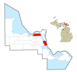
Township consists of two section in northeastern Chippewa County, connected by a stretch of the
988:
896:
891:
856:
846:
796:
761:
741:
731:
1013:
958:
933:
927:
911:
901:
881:
816:
806:
466:"Geographic Identifiers: 2010 Demographic Profile Data (G001): Soo township, Chippewa County MI"
968:
938:
906:
886:
866:
851:
826:
811:
776:
766:
756:
726:
234:
943:
876:
861:
781:
612:
917:
831:
922:
786:
630:
373:
353:
313:
32:
1074:
268:
429:
U.S. Geological Survey
Geographic Names Information System: Soo Township, Michigan
546:
321:
134:
107:
94:
229:
381:. Its hundred-odd permanent residents comprise an unincorporated community.
1041:‡This populated place also has portions in an adjacent county or counties.
325:
241:
139:
582:
564:
356:, 9 miles (14 km) downriver from the rest of the township.
503:
494:
581:
300:
407:
468:. US Census Bureau, American Factfinder. Archived from
1036:
1012:
740:
717:
629:
611:
593:
563:
295:
284:
274:
262:
240:
228:
220:
212:
207:
199:
191:
183:
175:
170:
162:
157:
145:
133:
123:
23:
390:In 2010, the township had a population of 3,141.
586:Map of Michigan highlighting Chippewa County.svg
515:
8:
377:is separated from the township by waters of
348:and is bordered to the north by the city of
522:
508:
500:
344:. The northwestern section is part of the
20:
18:Civil township in Michigan, United States
399:
294:
273:
239:
227:
206:
198:
169:
156:
122:
87:
53:
38:
1081:Townships in Chippewa County, Michigan
283:
261:
219:
211:
190:
182:
174:
161:
144:
132:
80:Location within the state of Michigan
7:
187:50.1 sq mi (129.8 km)
179:67.9 sq mi (175.9 km)
67:
195:17.8 sq mi (46.1 km)
530:Municipalities and communities of
328:. The population was 2,966 at the
14:
66:
59:
40:
1:
495:Soo Township official website
1027:Sault Ste. Marie Reservation
346:Upper Peninsula of Michigan
1102:
1022:Bay Mills Indian Community
1046:
579:
544:
533:Chippewa County, Michigan
88:
54:
39:
30:
203:581 ft (177 m)
163: • Supervisor
994:Westons Iroquois Beach
587:
25:Soo Township, Michigan
1086:Townships in Michigan
585:
441:"Explore Census Data"
408:"U.S. Census website"
224:44/sq mi (17/km)
108:46.41972°N 84.31111°W
1059:United States portal
472:on February 12, 2020
221: • Density
1014:Indian reservations
113:46.41972; -84.31111
104: /
1004:Whitehouse Landing
588:
410:. US Census Bureau
213: • Total
192: • Water
176: • Total
1068:
1067:
792:Dollar Settlement
359:According to the
307:
306:
184: • Land
1093:
1060:
1053:
802:Dorgans Crossing
613:Charter township
584:
573:Sault Ste. Marie
556:
555:Sault Ste. Marie
549:
539:
534:
524:
517:
510:
501:
482:
481:
479:
477:
462:
456:
455:
453:
451:
437:
431:
426:
420:
419:
417:
415:
404:
361:US Census Bureau
350:Sault Ste. Marie
303:
301:Official website
255:Sault Ste. Marie
119:
118:
116:
115:
114:
109:
105:
102:
101:
100:
97:
70:
69:
63:
46:Location within
44:
21:
1101:
1100:
1096:
1095:
1094:
1092:
1091:
1090:
1071:
1070:
1069:
1064:
1058:
1052:Michigan portal
1051:
1042:
1032:
1008:
999:Whitefish Point
822:Eckerman Corner
743:
736:
713:
631:Civil townships
625:
607:
589:
577:
559:
554:
547:
540:
537:
532:
528:
491:
486:
485:
475:
473:
464:
463:
459:
449:
447:
445:data.census.gov
439:
438:
434:
427:
423:
413:
411:
406:
405:
401:
396:
388:
379:St. Marys River
369:
342:St. Marys River
338:
318:Chippewa County
299:
258:
252:
112:
110:
106:
103:
98:
95:
93:
91:
90:
84:
83:
82:
81:
78:
77:
76:
75:
71:
50:
48:Chippewa County
35:
26:
19:
12:
11:
5:
1099:
1097:
1089:
1088:
1083:
1073:
1072:
1066:
1065:
1063:
1062:
1055:
1047:
1044:
1043:
1040:
1038:
1034:
1033:
1031:
1030:
1024:
1018:
1016:
1010:
1009:
1007:
1006:
1001:
996:
991:
986:
981:
976:
974:Strongs Corner
971:
966:
961:
956:
951:
946:
941:
936:
931:
925:
920:
915:
909:
904:
899:
894:
889:
884:
879:
874:
869:
864:
859:
854:
849:
844:
839:
834:
829:
824:
819:
814:
809:
804:
799:
794:
789:
784:
779:
774:
769:
764:
759:
754:
748:
746:
738:
737:
735:
734:
729:
723:
721:
715:
714:
712:
711:
706:
701:
696:
691:
686:
681:
676:
671:
666:
661:
656:
651:
646:
641:
635:
633:
627:
626:
624:
623:
617:
615:
609:
608:
606:
605:
603:DeTour Village
599:
597:
591:
590:
580:
578:
576:
575:
569:
567:
561:
560:
545:
542:
541:
529:
527:
526:
519:
512:
504:
498:
497:
490:
489:External links
487:
484:
483:
457:
432:
421:
398:
397:
395:
392:
387:
384:
383:
382:
374:Neebish Island
368:
365:
354:Neebish Island
337:
334:
314:civil township
305:
304:
297:
293:
292:
289:
282:
281:
278:
272:
271:
266:
260:
259:
246:
244:
238:
237:
232:
226:
225:
222:
218:
217:
214:
210:
209:
205:
204:
201:
197:
196:
193:
189:
188:
185:
181:
180:
177:
173:
172:
168:
167:
164:
160:
159:
155:
154:
149:
143:
142:
137:
131:
130:
127:
121:
120:
86:
85:
79:
73:
72:
65:
64:
58:
57:
56:
55:
52:
51:
45:
37:
36:
33:Civil township
31:
28:
27:
24:
17:
13:
10:
9:
6:
4:
3:
2:
1098:
1087:
1084:
1082:
1079:
1078:
1076:
1061:
1056:
1054:
1049:
1048:
1045:
1039:
1035:
1028:
1025:
1023:
1020:
1019:
1017:
1015:
1011:
1005:
1002:
1000:
997:
995:
992:
990:
987:
985:
982:
980:
977:
975:
972:
970:
967:
965:
964:Stirlingville
962:
960:
957:
955:
952:
950:
947:
945:
942:
940:
937:
935:
932:
929:
926:
924:
921:
919:
916:
913:
910:
908:
905:
903:
900:
898:
895:
893:
890:
888:
885:
883:
880:
878:
875:
873:
870:
868:
865:
863:
860:
858:
855:
853:
850:
848:
845:
843:
840:
838:
835:
833:
830:
828:
825:
823:
820:
818:
815:
813:
810:
808:
805:
803:
800:
798:
795:
793:
790:
788:
785:
783:
780:
778:
775:
773:
770:
768:
765:
763:
760:
758:
755:
753:
752:Baie de Wasai
750:
749:
747:
745:
739:
733:
730:
728:
725:
724:
722:
720:
716:
710:
707:
705:
702:
700:
697:
695:
692:
690:
687:
685:
682:
680:
677:
675:
672:
670:
667:
665:
662:
660:
657:
655:
652:
650:
647:
645:
642:
640:
637:
636:
634:
632:
628:
622:
619:
618:
616:
614:
610:
604:
601:
600:
598:
596:
592:
574:
571:
570:
568:
566:
562:
558:
557:
550:
543:
538:United States
535:
525:
520:
518:
513:
511:
506:
505:
502:
496:
493:
492:
488:
476:September 26,
471:
467:
461:
458:
446:
442:
436:
433:
430:
425:
422:
409:
403:
400:
393:
391:
385:
380:
376:
375:
371:
370:
366:
364:
362:
357:
355:
351:
347:
343:
335:
333:
331:
327:
323:
319:
315:
311:
302:
298:
290:
287:
279:
277:
270:
267:
265:
256:
250:
245:
243:
236:
233:
231:
223:
215:
202:
194:
186:
178:
165:
153:
150:
148:
141:
138:
136:
129:United States
128:
126:
117:
89:Coordinates:
62:
49:
43:
34:
29:
22:
16:
694:Sugar Island
688:
552:
474:. Retrieved
470:the original
460:
448:. Retrieved
444:
435:
424:
412:. Retrieved
402:
389:
386:Demographics
372:
358:
339:
310:Soo Township
309:
308:
166:Larry Perron
74:Soo Township
15:
954:Snug Harbor
837:Gardenville
772:Churchville
744:communities
548:County seat
414:January 31,
367:Communities
330:2020 census
242:ZIP code(s)
111: /
1075:Categories
984:Trout Lake
979:Timberlost
949:Shelldrake
842:Goetzville
704:Trout Lake
394:References
322:U.S. state
288:feature ID
208:Population
158:Government
99:84°18′40″W
96:46°25′11″N
1037:Footnotes
989:Vermilion
897:Oak Ridge
892:Munuscong
857:Johnswood
847:Homestead
797:Donaldson
762:Bay Mills
732:Kincheloe
709:Whitefish
639:Bay Mills
336:Geography
276:FIPS code
264:Area code
230:Time zone
200:Elevation
959:Stalwart
934:Rosedale
928:Rockview
912:Pickford
902:Paradise
882:McCarron
817:Eckerman
807:Drummond
699:Superior
674:Pickford
664:Drummond
649:Chippewa
326:Michigan
280:26-74620
152:Chippewa
140:Michigan
969:Strongs
939:Rudyard
907:Payment
887:Mission
872:Lincoln
867:Kinross
852:Hulbert
827:Emerson
812:Dryburg
777:Cordell
767:Brassar
757:Barbeau
727:Brimley
684:Rudyard
669:Hulbert
621:Kinross
595:Village
320:in the
296:Website
291:1627091
253:49783 (
249:Barbeau
247:49710 (
235:Eastern
125:Country
944:Seewhy
877:Maxton
862:Kelden
782:Dafter
659:DeTour
654:Dafter
450:May 2,
147:County
918:Raber
832:Fibre
742:Other
679:Raber
644:Bruce
312:is a
216:2,966
135:State
923:Raco
787:Dick
719:CDPs
565:City
478:2014
452:2024
416:2008
286:GNIS
171:Area
689:Soo
324:of
316:of
269:906
1077::
551::
536:,
443:.
332:.
1029:‡
930:‡
914:‡
523:e
516:t
509:v
480:.
454:.
418:.
257:)
251:)
Text is available under the Creative Commons Attribution-ShareAlike License. Additional terms may apply.