278:
293:
29:
221:
There is little forest except some areas of planted pines. The volcano's soil is arid, and its ecosystem is very simple. Few plants grow in
Songaksan because due to grazing on its fields. Typical plants are perennial
277:
217:
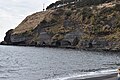
Route 10. Songaksan makes a shore cliff to the south, and the south part of crater forms a low and flat grassland in front of which lie slopes. Black and red volcanic ash still remain inside the crater.
210:. Crater 1 is about 500 m in diameter, 1.7 km in circumference. Crater 2, the mouth of the volcano in Crater 1, is about 400 m in diameter, 69 m in depth and leans vertically.
247:, there are remains of their presence including an airstrip and airship sheds. Under the shore cliff, there are still 15 trenches remaining from that era.
292:
55:
391:
334:
213:
From
Sanyisu-dong to the summit and ridge of Songaksan there are various trails along the coast and on the volcano. Songaksan is along
381:
406:
156:
48:
263:
240:
236:
170:
224:
214:
193:
207:
400:
329:
99:
33:
The mountain is visible in the distance on the left, in front of the taller mountain
283:
244:
203:
386:
299:
259:
34:
354:
70:
57:
313:
229:
28:
286:–era caves dug out by Japanese soldiers on the coast of the mountain (2018)
323:
95:
161:
146:
143:
140:
318:
255:
251:
116:
132:
175:
239:
occupied
Songaksan to use as a steppingstone toward its
258:Island appear very close. Diverse fish such as the
169:
155:
131:
115:
110:
91:
86:
47:
42:
21:
250:From the observation platform, the southernmost
206:, South Korea, which has double craters and a
8:
197:
138:
122:
18:
346:
273:
7:
382:Jeju Special Self-governing Province
335:Jeju Volcanic Island and Lava Tubes
298:View from the top of the mountain.
16:Volcano on Jeju Island, South Korea
14:
291:
276:
27:
198:
139:
123:
1:
355:"Jejuolle Trail - Route 10"
176:
162:
423:
183:
106:
26:
407:Volcanoes of South Korea
302:is to the left (2014)
157:Revised Romanization
67: /
202:) is a volcano on
71:33.199°N 126.291°E
43:Highest point
266:are caught here.
241:invasion of China
187:
186:
171:McCune–Reischauer
414:
369:
368:
366:
365:
359:www.jejuolle.org
351:
295:
280:
201:
200:
179:
165:
150:
149:
126:
125:
82:
81:
79:
78:
77:
72:
68:
65:
64:
63:
60:
31:
19:
422:
421:
417:
416:
415:
413:
412:
411:
397:
396:
392:Jeju Olle Trail
378:
373:
372:
363:
361:
353:
352:
348:
343:
310:
303:
296:
287:
281:
272:
260:saw-edged perch
215:Jeju Olle Trail
151:
127:
76:33.199; 126.291
75:
73:
69:
66:
61:
58:
56:
54:
53:
38:
17:
12:
11:
5:
420:
418:
410:
409:
399:
398:
395:
394:
389:
387:Jeju Tour Info
384:
377:
376:External links
374:
371:
370:
345:
344:
342:
339:
338:
337:
332:
327:
321:
316:
309:
306:
305:
304:
297:
290:
288:
282:
275:
271:
268:
208:parasitic cone
185:
184:
181:
180:
173:
167:
166:
159:
153:
152:
137:
135:
129:
128:
121:
119:
113:
112:
108:
107:
104:
103:
93:
89:
88:
84:
83:
51:
45:
44:
40:
39:
32:
24:
23:
15:
13:
10:
9:
6:
4:
3:
2:
419:
408:
405:
404:
402:
393:
390:
388:
385:
383:
380:
379:
375:
360:
356:
350:
347:
340:
336:
333:
331:
330:Jeju Uprising
328:
325:
322:
320:
317:
315:
312:
311:
307:
301:
294:
289:
285:
279:
274:
269:
267:
265:
261:
257:
253:
248:
246:
242:
238:
237:Japanese army
233:
231:
227:
226:
219:
216:
211:
209:
205:
195:
191:
182:
178:
174:
172:
168:
164:
160:
158:
154:
148:
145:
142:
136:
134:
130:
120:
118:
114:
109:
105:
102:, South Korea
101:
100:Jeju Province
97:
94:
90:
85:
80:
52:
50:
46:
41:
36:
30:
25:
20:
362:. Retrieved
358:
349:
284:World War II
249:
245:World War II
235:Because the
234:
223:
220:
212:
189:
188:
264:black porgy
254:Island and
204:Jeju Island
196::
111:Korean name
74: /
62:126°17′28″E
49:Coordinates
364:2024-06-15
341:References
300:Sanbangsan
59:33°11′56″N
35:Sanbangsan
314:Olle road
230:broomrape
225:Artemisia
190:Songaksan
177:Songaksan
163:Songaksan
87:Geography
22:Songaksan
401:Category
326:Mountain
324:Hallasan
308:See also
96:Seogwipo
92:Location
270:Gallery
319:Marado
256:Gapado
252:Marado
194:Korean
117:Hangul
37:(2012)
133:Hanja
262:and
228:and
243:in
199:송악산
124:송악산
403::
357:.
232:.
98:,
367:.
192:(
147:山
144:岳
141:松
Text is available under the Creative Commons Attribution-ShareAlike License. Additional terms may apply.