599:
38:
339:
29:
374:
after receiving Meadow Creek from the left. Hungry Horse
Reservoir occupies much of the lower half of the river, covering 97 square miles (250 km). The reservoir trends north then northwest, and the river then passes through the arched
370:. For some 40 miles (64 km), the river flows freely north-northwest, meandering through a forested and undeveloped valley. The river enters a narrow gorge, running north, then begins to enter the backwater of
473:; Potts, Donald F.; Running, Steven W.; Kimball, John S.; DeLuca, Thomas H.; Fagre, Daniel B.; Makepeace, Seth; Hendrix, Marc S.; Johnnie, N. Moore; Lorang, Mark S.; Ellis, Bonnie K. (30 July 2004).
169:
849:
527:
379:, just a few miles above the mouth. After it leaves the dam, the river enters a narrow gorge and, exiting the canyon for the final time, runs northwest past the town of
107:
474:
844:
839:
449:
421:
520:
286:
335:). The north-northwest trending river is about 98 miles (158 km) long, making it the second longest tributary of the Flathead River.
440:
412:
513:
668:
445:
417:
505:
643:
355:
762:
834:
485:
359:
384:
537:
76:
435:
407:
610:
578:
351:
343:
804:
781:
744:
371:
719:
653:
648:
380:
811:
678:
729:
699:
470:
754:
638:
588:
583:
559:
332:
709:
694:
663:
683:
623:
618:
376:
328:
714:
704:
673:
739:
689:
633:
628:
363:
324:
274:
268:
828:
658:
320:
56:
37:
552:
362:, at the confluence of two streams, Danaher Creek and Youngs Creek, between the
152:
773:
383:, then joins the Flathead River, just a few miles below its headwaters at the
367:
185:
171:
123:
109:
338:
28:
795:‡This populated place also has portions in an adjacent county or counties
475:"Flathead River Basin Hydrologic Observatory, Northern Rocky Mountains"
316:
66:
482:
Consortium of
Universities for the Advancement of Hydrologic Science
337:
570:
509:
42:
Map of the
Flathead River drainage basin showing the South Fork
597:
790:
772:
753:
728:
609:
569:
293:
284:
266:
261:
247:
239:
227:
219:
209:
161:
151:
99:
91:
82:
72:
62:
52:
47:
21:
521:
8:
850:Wild and Scenic Rivers of the United States
598:
323:. It is one of the three main forks of the
528:
514:
506:
36:
450:United States Department of the Interior
422:United States Department of the Interior
396:
253:3,483 cu ft/s (98.6 m/s)
402:
400:
18:
292:
283:
231:1,663 sq mi (4,310 km)
7:
441:Geographic Names Information System
413:Geographic Names Information System
845:Rivers of Flathead County, Montana
536:Municipalities and communities of
14:
840:Tributaries of the Columbia River
315:is a major river in Northwestern
484:. www.cuahsi.org. Archived from
27:
446:United States Geological Survey
418:United States Geological Survey
387:and Middle Forks' convergence.
16:River in Montana, United States
287:National Wild and Scenic River
163: • coordinates
101: • coordinates
1:
83:Physical characteristics
342:Hungry Horse Reservoir with
211: • elevation
763:Flathead Indian Reservation
436:"South Fork Flathead River"
408:"South Fork Flathead River"
866:
360:Middle Fork Flathead River
249: • average
800:
595:
550:
313:South Fork Flathead River
305:
301:
280:
257:
235:
197:South Fork Flathead River
147:
135:South Fork Flathead River
87:
35:
26:
22:South Fork Flathead River
539:Flathead County, Montana
350:The river begins in the
352:Bob Marshall Wilderness
344:Great Northern Mountain
215:3,031 feet (924 m)
669:Little Bitterroot Lake
603:
372:Hungry Horse Reservoir
347:
223:98 miles (158 km)
186:48.38944°N 114.08833°W
124:47.44556°N 113.18361°W
601:
356:Glacier National Park
341:
327:, a tributary of the
813:United States portal
191:48.38944; -114.08833
129:47.44556; -113.18361
644:Forest Hill Village
602:Flathead County map
262:Basin features
181: /
119: /
755:Indian reservation
604:
348:
333:Pend Oreille River
835:Rivers of Montana
822:
821:
471:Woessner, William
319:in the northwest
309:
308:
857:
814:
807:
600:
562:
555:
545:
540:
530:
523:
516:
507:
500:
499:
497:
496:
490:
479:
467:
461:
460:
458:
457:
432:
426:
425:
404:
377:Hungry Horse Dam
329:Clark Fork River
297:October 12, 1976
271:
250:
205:
204:
202:
201:
200:
198:
193:
192:
187:
182:
179:
178:
177:
174:
143:
142:
140:
139:
138:
136:
131:
130:
125:
120:
117:
116:
115:
112:
102:
40:
31:
19:
865:
864:
860:
859:
858:
856:
855:
854:
825:
824:
823:
818:
812:
805:
796:
786:
768:
749:
731:
724:
605:
593:
565:
560:
553:
546:
543:
538:
534:
504:
503:
494:
492:
491:on 27 June 2006
488:
477:
469:
468:
464:
455:
453:
434:
433:
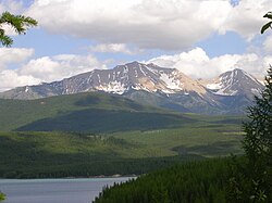
429:
406:
405:
398:
393:
289:
267:
248:
212:
196:
194:
190:
188:
184:
183:
180:
175:
172:
170:
168:
167:
164:
134:
132:
128:
126:
122:
121:
118:
113:
110:
108:
106:
105:
100:
43:
17:
12:
11:
5:
863:
861:
853:
852:
847:
842:
837:
827:
826:
820:
819:
817:
816:
809:
806:Montana portal
801:
798:
797:
794:
792:
788:
787:
785:
784:
778:
776:
770:
769:
767:
766:
759:
757:
751:
750:
748:
747:
742:
736:
734:
726:
725:
723:
722:
717:
712:
707:
702:
697:
692:
687:
681:
676:
671:
666:
661:
656:
651:
646:
641:
636:
631:
626:
621:
615:
613:
607:
606:
596:
594:
592:
591:
586:
581:
579:Columbia Falls
575:
573:
567:
566:
551:
548:
547:
535:
533:
532:
525:
518:
510:
502:
501:
462:
452:. 4 April 1980
427:
395:
394:
392:
389:
364:Flathead Range
358:, as does the
325:Flathead River
307:
306:
303:
302:
299:
298:
295:
291:
290:
285:
282:
281:
278:
277:
275:Columbia River
272:
264:
263:
259:
258:
255:
254:
251:
245:
244:
241:
237:
236:
233:
232:
229:
225:
224:
221:
217:
216:
213:
210:
207:
206:
165:
162:
159:
158:
155:
149:
148:
145:
144:
103:
97:
96:
93:
89:
88:
85:
84:
80:
79:
74:
70:
69:
64:
60:
59:
54:
50:
49:
45:
44:
41:
33:
32:
24:
23:
15:
13:
10:
9:
6:
4:
3:
2:
862:
851:
848:
846:
843:
841:
838:
836:
833:
832:
830:
815:
810:
808:
803:
802:
799:
793:
789:
783:
782:McCarthyville
780:
779:
777:
775:
771:
764:
761:
760:
758:
756:
752:
746:
745:Lake McDonald
743:
741:
738:
737:
735:
733:
727:
721:
718:
716:
713:
711:
708:
706:
703:
701:
698:
696:
693:
691:
688:
685:
682:
680:
677:
675:
672:
670:
667:
665:
662:
660:
657:
655:
652:
650:
647:
645:
642:
640:
637:
635:
632:
630:
627:
625:
622:
620:
617:
616:
614:
612:
608:
590:
587:
585:
582:
580:
577:
576:
574:
572:
568:
564:
563:
556:
549:
544:United States
541:
531:
526:
524:
519:
517:
512:
511:
508:
487:
483:
476:
472:
466:
463:
451:
447:
443:
442:
437:
431:
428:
423:
419:
415:
414:
409:
403:
401:
397:
390:
388:
386:
382:
378:
373:
369:
365:
361:
357:
353:
345:
340:
336:
334:
330:
326:
322:
321:United States
318:
314:
304:
300:
296:
288:
279:
276:
273:
270:
265:
260:
256:
252:
246:
242:
238:
234:
230:
226:
222:
218:
214:
208:
203:
166:
160:
156:
154:
150:
146:
141:
104:
98:
94:
90:
86:
81:
78:
75:
71:
68:
65:
61:
58:
57:United States
55:
51:
46:
39:
34:
30:
25:
20:
720:West Glacier
654:Hungry Horse
649:Helena Flats
558:
493:. Retrieved
486:the original
481:
465:
454:. Retrieved
439:
430:
411:
381:Hungry Horse
349:
312:
310:
269:River system
732:communities
679:Martin City
554:County seat
189: /
176:114°05′18″W
127: /
114:113°11′01″W
829:Categories
774:Ghost town
700:Polebridge
495:2009-08-29
456:2009-08-29
385:North Fork
368:Swan Range
294:Designated
228:Basin size
195: (
173:48°23′22″N
133: (
111:47°26′44″N
791:Footnotes
639:Evergreen
589:Whitefish
584:Kalispell
561:Kalispell
354:south of
240:Discharge
710:Snowslip
695:Pinnacle
664:Lakeside
366:and the
77:Flathead
48:Location
684:Niarada
624:Bigfork
619:Batavia
317:Montana
67:Montana
53:Country
715:Somers
705:Rhodes
674:Marion
571:Cities
346:beyond
243:
220:Length
157:
95:
92:Source
73:County
740:Apgar
730:Other
690:Olney
634:Essex
629:Coram
489:(PDF)
478:(PDF)
391:Notes
331:(the
153:Mouth
63:State
659:Kila
611:CDPs
311:The
831::
557::
542:,
480:.
448:,
444:.
438:.
420:,
416:.
410:.
399:^
765:‡
686:‡
529:e
522:t
515:v
498:.
459:.
424:.
199:)
137:)
Text is available under the Creative Commons Attribution-ShareAlike License. Additional terms may apply.