567:). Due to industrial usage and highway widening projects in the 1970s, much of the Middle Fork was severely ecologically degraded. Since 2000, the Middle Fork Greenway project has been working to create a 6.5-mile recreational greenway between the two cities. Additionally, work is being done to restore native plants and damaged sections of the river.
866:
847:
886:
793:
685:
881:
896:
739:
876:
840:
786:
678:
29:
891:
833:
732:
373:
871:
779:
671:
562:
809:
79:
611:
755:
725:
506:
292:
211:
193:
130:
75:
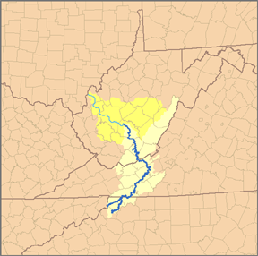
494:
112:
701:
510:
355:
83:
498:
576:
542:
522:
432:
343:
38:
600:
561:
runs between the towns of
Blowing Rock and Boone and is fed by tributaries including the Aho Branch Creek (
538:
514:
274:
581:
518:
502:
546:
534:
817:
813:
763:
759:
709:
705:
655:
487:
359:
278:
197:
116:
65:
860:
526:
55:
34:
28:
601:
U.S. Geological Survey
Geographic Names Information System: South Fork New River
338:
615:
530:
483:
388:
375:
307:
294:
226:
213:
145:
132:
628:
479:
525:. Its waters ultimately reach the Gulf of Mexico through the
513:
in northwestern North
Carolina, passing through the town of
501:
and meanders northward along the northwestern face of the
629:"Middle Fork Greenway, A Blue Ridge Conservancy Project"
821:
767:
713:
659:
654:
This article related to a river in North
Carolina is a
867:
Tributaries of the New River (Kanawha River tributary)
616:
USGS 03161000 SOUTH FORK NEW RIVER NEAR JEFFERSON, NC
563:
458:
448:
438:
426:
418:
404:
365:
349:
337:
323:
284:
268:
260:
242:
203:
187:
179:
161:
122:
106:
98:
89:
71:
61:
51:
46:
21:
493:It stretches from its headwaters at a spring near
841:
787:
733:
679:
8:
505:through the eastern and central portions of
464:2,120 cu ft/s (60 m/s)(1998)
887:Rivers of Alleghany County, North Carolina
848:
834:
794:
780:
740:
726:
686:
672:
454:227 cu ft/s (6.4 m/s)(1986)
882:Rivers of Watauga County, North Carolina
593:
897:Western North Carolina geography stubs
18:
16:River in North Carolina, United States
877:Rivers of Ashe County, North Carolina
444:552 cu ft/s (15.6 m/s)
7:
805:
803:
751:
749:
697:
695:
651:
649:
14:
808:This article about a location in
754:This article about a location in
700:This article about a location in
102:Middle Fork South Fork New River
27:
612:United States Geological Survey
367: • coordinates
286: • coordinates
205: • coordinates
183:East Fork South Fork New River
124: • coordinates
41:and its watershed highlighted.
1:
90:Physical characteristics
820:. You can help Knowledge by
766:. You can help Knowledge by
712:. You can help Knowledge by
658:. You can help Knowledge by
406: • elevation
325: • elevation
244: • elevation
167:3,543 ft (1,080 m)
163: • elevation
618:; retrieved April 19, 2008.
521:in Ashe County to form the
428: • location
351: • location
270: • location
189: • location
108: • location
913:
892:North Carolina river stubs
802:
748:
694:
648:
537:. Its tributaries include
499:Eastern Continental Divide
460: • maximum
450: • minimum
440: • average
410:2,546 ft (776 m)
329:3,104 ft (946 m)
248:3,271 ft (997 m)
468:
414:
333:
256:
252:
175:
171:
94:
26:
872:Rivers of North Carolina
389:36.54611°N 81.35306°W
308:36.20444°N 81.64972°W
227:36.18222°N 81.61028°W
146:36.12611°N 81.67222°W
582:North Fork New River
519:North Fork New River
503:Blue Ridge Mountains
476:South Fork New River
37:watershed, with the
22:South Fork New River
543:Boone (Kraut) Creek
394:36.54611; -81.35306
385: /
313:36.20444; -81.64972
304: /
232:36.18222; -81.61028
223: /
151:36.12611; -81.67222
142: /
829:
828:
775:
774:
721:
720:
667:
666:
535:Mississippi River
472:
471:
261:Source confluence
904:
850:
843:
836:
810:Alleghany County
804:
796:
789:
782:
750:
742:
735:
728:
696:
688:
681:
674:
650:
640:
639:
637:
635:
625:
619:
609:
603:
598:
461:
451:
441:
429:
400:
399:
397:
396:
395:
390:
386:
383:
382:
381:
378:
326:
319:
318:
316:
315:
314:
309:
305:
302:
301:
300:
297:
287:
271:
245:
238:
237:
235:
234:
233:
228:
224:
221:
220:
219:
216:
206:
190:
164:
157:
156:
154:
153:
152:
147:
143:
140:
139:
138:
135:
125:
109:
31:
19:
912:
911:
907:
906:
905:
903:
902:
901:
857:
856:
855:
854:
801:
800:
747:
746:
693:
692:
646:
644:
643:
633:
631:
627:
626:
622:
610:
606:
599:
595:
590:
573:
555:
539:Winkler's Creek
517:. It joins the
459:
449:
439:
427:
407:
393:
391:
387:
384:
379:
376:
374:
372:
371:
368:
352:
324:
312:
310:
306:
303:
298:
295:
293:
291:
290:
285:
269:
243:
231:
229:
225:
222:
217:
214:
212:
210:
209:
204:
188:
162:
150:
148:
144:
141:
136:
133:
131:
129:
128:
123:
107:
42:
17:
12:
11:
5:
910:
908:
900:
899:
894:
889:
884:
879:
874:
869:
859:
858:
853:
852:
845:
838:
830:
827:
826:
814:North Carolina
799:
798:
791:
784:
776:
773:
772:
760:North Carolina
756:Watauga County
745:
744:
737:
730:
722:
719:
718:
706:North Carolina
691:
690:
683:
676:
668:
665:
664:
642:
641:
620:
604:
592:
591:
589:
586:
585:
584:
579:
572:
569:
554:
551:
507:Watauga County
488:North Carolina
470:
469:
466:
465:
462:
456:
455:
452:
446:
445:
442:
436:
435:
430:
424:
423:
420:
416:
415:
412:
411:
408:
405:
402:
401:
369:
366:
363:
362:
353:
350:
347:
346:
341:
335:
334:
331:
330:
327:
321:
320:
288:
282:
281:
272:
266:
265:
262:
258:
257:
254:
253:
250:
249:
246:
240:
239:
207:
201:
200:
194:Watauga County
191:
185:
184:
181:
177:
176:
173:
172:
169:
168:
165:
159:
158:
126:
120:
119:
110:
104:
103:
100:
96:
95:
92:
91:
87:
86:
73:
69:
68:
66:North Carolina
63:
59:
58:
53:
49:
48:
44:
43:
32:
24:
23:
15:
13:
10:
9:
6:
4:
3:
2:
909:
898:
895:
893:
890:
888:
885:
883:
880:
878:
875:
873:
870:
868:
865:
864:
862:
851:
846:
844:
839:
837:
832:
831:
825:
823:
819:
815:
811:
806:
797:
792:
790:
785:
783:
778:
777:
771:
769:
765:
761:
757:
752:
743:
738:
736:
731:
729:
724:
723:
717:
715:
711:
707:
703:
698:
689:
684:
682:
677:
675:
670:
669:
663:
661:
657:
652:
647:
630:
624:
621:
617:
613:
608:
605:
602:
597:
594:
587:
583:
580:
578:
575:
574:
570:
568:
566:
565:
560:
552:
550:
548:
544:
540:
536:
532:
528:
527:Kanawha River
524:
520:
516:
512:
508:
504:
500:
496:
491:
489:
485:
481:
477:
467:
463:
457:
453:
447:
443:
437:
434:
433:Jefferson, NC
431:
425:
421:
417:
413:
409:
403:
398:
370:
364:
361:
357:
354:
348:
345:
342:
340:
336:
332:
328:
322:
317:
289:
283:
280:
276:
273:
267:
263:
259:
255:
251:
247:
241:
236:
208:
202:
199:
195:
192:
186:
182:
178:
174:
170:
166:
160:
155:
127:
121:
118:
114:
111:
105:
101:
97:
93:
88:
85:
81:
77:
74:
70:
67:
64:
60:
57:
56:United States
54:
50:
45:
40:
36:
35:Kanawha River
30:
25:
20:
822:expanding it
807:
768:expanding it
753:
714:expanding it
699:
660:expanding it
653:
645:
632:. Retrieved
623:
607:
596:
558:
556:
547:Payne Branch
495:Blowing Rock
492:
475:
473:
113:Blowing Rock
702:Ashe County
559:Middle Fork
553:Middle Fork
511:Ashe County
392: /
356:Ashe County
311: /
230: /
149: /
33:Map of the
861:Categories
588:References
533:, and the
531:Ohio River
484:U.S. state
380:81°21′11″W
377:36°32′46″N
299:81°38′59″W
296:36°12′16″N
218:81°36′37″W
215:36°10′56″N
180:2nd source
137:81°40′20″W
134:36°07′34″N
577:New River
523:New River
509:and then
419:Discharge
344:New River
80:Alleghany
39:New River
571:See also
497:and the
72:Counties
47:Location
634:June 5,
482:in the
76:Watauga
52:Country
529:, the
422:
264:
99:Source
816:is a
762:is a
708:is a
564:AY-ho
515:Boone
480:river
478:is a
339:Mouth
275:Boone
62:State
818:stub
764:stub
710:stub
656:stub
636:2022
557:The
545:and
474:The
84:Ashe
486:of
863::
812:,
758:,
704:,
614:;
549:.
541:,
490:.
360:NC
358:,
279:NC
277:,
198:NC
196:,
117:NC
115:,
82:,
78:,
849:e
842:t
835:v
824:.
795:e
788:t
781:v
770:.
741:e
734:t
727:v
716:.
687:e
680:t
673:v
662:.
638:.
Text is available under the Creative Commons Attribution-ShareAlike License. Additional terms may apply.