31:
958:
46:
230:
in 2023 found that the bight contained 14 rocky reefs with abundant life including "kelp forests, macroalgal meadows, and gardens of 39 species of sponge. Blue cod (including nurseries at four sites), scarlet wrasse, butterfly perch, leatherjackets and tarakihi dominated the fish species, also
319:
218:
in 2007 and the South
Taranaki Bight was confirmed in 2014 as the only known feeding and foraging ground for blue whales in New Zealand, hosting a unique population of its own. Blue whales also frequent an area off
186:
when sea levels were over 100 metres (330 ft) lower than present day levels, the South
Taranaki Bight was a coastal plain which connected the North and South Islands, featuring rivers which drained into the
489:
346:
328:
227:
532:
809:
342:
298:
999:
911:
438:
210:
after the large number of cow-calf pairs. However right whale numbers were greatly reduced by whaling and only a handful of cows visit regularly today.
191:(then a harbour) to the south-east. Sea levels began to rise 7,000 years ago, eventually separating the islands and connecting the Cook Strait to the
368:
73:
525:
412:
456:
1038:
906:
1018:
518:
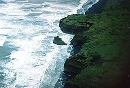
992:
273:
1028:
1023:
1033:
30:
985:
435:
927:
870:
865:
778:
541:
937:
932:
819:
399:
385:
235:
554:
436:
Blue whale ecology in the South
Taranaki Bight region of New Zealand: January-February 2016 Field Report
168:
152:
839:
247:
203:
183:
896:
582:
373:
891:
829:
717:
712:
642:
572:
788:
849:
783:
408:
199:
969:
901:
793:
612:
211:
748:
471:
442:
220:
773:
763:
753:
510:
268:
176:
172:
164:
125:
1012:
758:
105:
957:
702:
637:
306:
160:
59:
844:
834:
707:
738:
592:
545:
215:
188:
156:
144:
131:
824:
814:
722:
697:
667:
192:
118:
45:
88:
75:
743:
682:
617:
597:
587:
558:
965:
875:
672:
622:
148:
299:"Evidence for an unrecognised blue whale foraging ground in New Zealand"
692:
662:
652:
602:
687:
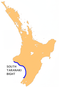
647:
632:
627:
607:
677:
657:
577:
206:
in winter and spring and early
Europeans in New Zealand called it
36:
514:
401:
Taranaki – Where We Stand: State of the
Environment Report 2009
321:
South
Taranaki Bight Factual Baseline Environmental Report
973:
163:. The name is sometimes used for a much smaller bay in
303:
New
Zealand Journal of Marine and Freshwater Research
284:– via Te Ara – the Encyclopedia of New Zealand.
231:
including snapper, trevally, kingfish, and kahawai".
347:
National
Institute of Water and Atmospheric Research
329:
National
Institute of Water and Atmospheric Research
228:
National
Institute of Water and Atmospheric Research
920:
884:
858:
802:
731:
565:
124:
114:
104:
65:
55:
23:
457:"Blue whale dine out off Taranaki in their dozens"
407:. Taranaki Regional Council. 2009. p. 177.
66:
238:has proposed to mine iron sand from the bight.
993:
526:
434:Torres, Leigh; Klinck, Holger et al. (2016).
8:
293:
291:
155:, north and west of the western entrance of
912:Western Institute of Technology at Taranaki
1000:
986:
810:Aotea Utanganui – Museum of South Taranaki
533:
519:
511:
182:Approximately 18,000 years ago during the
20:
259:
490:"Pātea seabed mining fight continues"
267:Grant-Taylor, Thomas Ludovic (1966).
223:in the nearby northern South Island.
7:
954:
952:
483:
481:
369:"Rare whales sighted at Castlecliff"
143:is a large bay on the west coast of
972:. You can help Knowledge (XXG) by
14:
455:Harper, Laird (4 February 2014).
956:
488:Craig Ashworth (17 April 2024).
234:Australian-owned mining company
50:Location of South Taranaki Bight
44:
29:
274:An Encyclopaedia of New Zealand
445:(pdf). Retrieved 3 March 2017.
202:was once a calving ground for
1:
367:Poynton, Dan (28 July 2005).
54:
271:. In McLintock, A.H. (ed.).
845:Pātea Hydro Electric Scheme
167:, between the mouth of the
1055:
951:
803:Facilities and attractions
552:
309:. Retrieved 3 March 2017.
297:Torres, Leigh G. (2013).
43:
28:
1039:Taranaki geography stubs
1019:South Taranaki District
968:geography article is a
928:1901 Patea by-elections
542:South Taranaki District
226:A seabed survey by the
938:1954 Patea by-election
933:1921 Patea by-election
820:Cape Egmont Lighthouse
386:The New Zealand Herald
269:"South Taranaki Bight"
236:Trans-Tasman Resources
1029:Landforms of Taranaki
204:southern right whales
175:and the mouth of the
907:Waverley High School
840:Patea Freezing Works
769:South Taranaki Bight
248:North Taranaki Bight
214:were discovered off
184:Last Glacial Maximum
141:South Taranaki Bight
35:Taranaki coast near
24:South Taranaki Bight
1024:Bays of New Zealand
897:Opunake High School
732:Geographic features
461:Taranaki Daily News
374:Whanganui Chronicle
331:. 2011. p. 54.
85: /
18:Bay in North Island
1034:Bights (geography)
892:Hawera High School
830:Hawera Observatory
441:2017-03-03 at the
171:directly south of
89:39.667°S 174.167°E
981:
980:
946:
945:
850:Waipipi Wind Farm
784:Waingongoro River
414:978-0-473-14731-0
343:"Estuary origins"
212:Pygmy blue whales
169:Kaupokonui Stream
159:and north of the
137:
136:
1046:
1002:
995:
988:
960:
953:
902:Waitotara School
876:Regional Council
866:District Council
794:Whenuakura River
566:Populated places
535:
528:
521:
512:
505:
504:
502:
500:
485:
476:
475:
469:
467:
452:
446:
432:
426:
425:
423:
421:
406:
396:
390:
389:
383:
381:
364:
358:
357:
355:
353:
339:
333:
332:
326:
316:
310:
295:
286:
285:
283:
281:
264:
100:
99:
97:
96:
95:
94:-39.667; 174.167
90:
86:
83:
82:
81:
78:
68:
48:
33:
21:
1054:
1053:
1049:
1048:
1047:
1045:
1044:
1043:
1009:
1008:
1007:
1006:
949:
947:
942:
916:
880:
854:
798:
789:Waitōtara River
749:Manawapou River
727:
561:
548:
539:
509:
508:
498:
496:
487:
486:
479:
465:
463:
454:
453:
449:
443:Wayback Machine
433:
429:
419:
417:
415:
404:
398:
397:
393:
379:
377:
366:
365:
361:
351:
349:
341:
340:
336:
324:
318:
317:
313:
296:
289:
279:
277:
266:
265:
261:
256:
244:
221:Kahurangi Point
128: countries
93:
91:
87:
84:
79:
76:
74:
72:
71:
51:
39:
19:
12:
11:
5:
1052:
1050:
1042:
1041:
1036:
1031:
1026:
1021:
1011:
1010:
1005:
1004:
997:
990:
982:
979:
978:
961:
944:
943:
941:
940:
935:
930:
924:
922:
918:
917:
915:
914:
909:
904:
899:
894:
888:
886:
882:
881:
879:
878:
873:
868:
862:
860:
856:
855:
853:
852:
847:
842:
837:
832:
827:
822:
817:
812:
806:
804:
800:
799:
797:
796:
791:
786:
781:
776:
774:Tangahoe River
771:
766:
764:Lake Rotorangi
761:
756:
751:
746:
741:
735:
733:
729:
728:
726:
725:
720:
715:
710:
705:
700:
695:
690:
685:
680:
675:
670:
665:
660:
655:
650:
645:
640:
635:
630:
625:
620:
615:
610:
605:
600:
595:
590:
585:
580:
575:
569:
567:
563:
562:
553:
550:
549:
540:
538:
537:
530:
523:
515:
507:
506:
477:
447:
427:
413:
391:
359:
334:
327:. Wellington:
311:
287:
258:
257:
255:
252:
251:
250:
243:
240:
173:Mount Taranaki
165:South Taranaki
151:, west of the
135:
134:
129:
122:
121:
116:
112:
111:
108:
102:
101:
69:
63:
62:
57:
53:
52:
49:
41:
40:
34:
26:
25:
17:
13:
10:
9:
6:
4:
3:
2:
1051:
1040:
1037:
1035:
1032:
1030:
1027:
1025:
1022:
1020:
1017:
1016:
1014:
1003:
998:
996:
991:
989:
984:
983:
977:
975:
971:
967:
962:
959:
955:
950:
939:
936:
934:
931:
929:
926:
925:
923:
919:
913:
910:
908:
905:
903:
900:
898:
895:
893:
890:
889:
887:
885:Organisations
883:
877:
874:
872:
869:
867:
864:
863:
861:
857:
851:
848:
846:
843:
841:
838:
836:
833:
831:
828:
826:
823:
821:
818:
816:
813:
811:
808:
807:
805:
801:
795:
792:
790:
787:
785:
782:
780:
777:
775:
772:
770:
767:
765:
762:
760:
759:Lake Rotokare
757:
755:
752:
750:
747:
745:
742:
740:
737:
736:
734:
730:
724:
721:
719:
716:
714:
711:
709:
706:
704:
701:
699:
696:
694:
691:
689:
686:
684:
681:
679:
676:
674:
671:
669:
666:
664:
661:
659:
656:
654:
651:
649:
646:
644:
641:
639:
636:
634:
631:
629:
626:
624:
621:
619:
616:
614:
611:
609:
606:
604:
601:
599:
596:
594:
591:
589:
586:
584:
581:
579:
576:
574:
571:
570:
568:
564:
560:
556:
551:
547:
543:
536:
531:
529:
524:
522:
517:
516:
513:
495:
491:
484:
482:
478:
473:
462:
458:
451:
448:
444:
440:
437:
431:
428:
416:
410:
403:
402:
395:
392:
387:
376:
375:
370:
363:
360:
348:
344:
338:
335:
330:
323:
322:
315:
312:
308:
304:
300:
294:
292:
288:
276:
275:
270:
263:
260:
253:
249:
246:
245:
241:
239:
237:
232:
229:
224:
222:
217:
213:
209:
208:Mothering Bay
205:
201:
196:
194:
190:
185:
180:
178:
174:
170:
166:
162:
158:
154:
150:
146:
142:
133:
130:
127:
123:
120:
117:
113:
109:
107:
103:
98:
70:
64:
61:
58:
47:
42:
38:
32:
27:
22:
16:
974:expanding it
963:
948:
779:Waiaua River
768:
703:Waiinu Beach
638:Ngamatapouri
497:. Retrieved
493:
470:– via
464:. Retrieved
460:
450:
430:
418:. Retrieved
400:
394:
384:– via
378:. Retrieved
372:
362:
350:. Retrieved
337:
320:
314:
307:ResearchGate
302:
278:. Retrieved
272:
262:
233:
225:
207:
197:
181:
161:South Island
140:
138:
115:Part of
60:North Island
15:
754:Pātea River
739:Cape Egmont
593:Hurleyville
546:New Zealand
216:Cape Egmont
189:Cook Strait
177:Pātea River
157:Cook Strait
147:, south of
145:New Zealand
132:New Zealand
92: /
67:Coordinates
1013:Categories
859:Government
825:Kupe field
815:Bayly Park
723:Whenuakura
698:Rawhitiroa
466:31 October
420:31 October
380:31 October
352:3 November
280:31 October
254:References
193:Tasman Sea
119:Tasman Sea
835:Pātea Dam
744:Lake Dive
708:Waitōtara
683:Pungarehu
618:Mangatoki
598:Kakaramea
494:NZ Herald
966:Taranaki
718:Waverley
673:Parihaka
643:Normanby
623:Manutahi
499:17 April
439:Archived
242:See also
153:Manawatu
149:Taranaki
80:174°10′E
56:Location
921:History
693:Ramanui
668:Ōpunake
663:Okaiawa
653:Ohangai
603:Kaponga
305:47(2).
77:39°40′S
688:Rahotu
648:Oaonui
633:Mokoia
628:Matapu
613:Manaia
608:Kapuni
588:Hāwera
583:Eltham
559:Hāwera
411:
964:This
871:Mayor
713:Warea
678:Patea
658:Ohawe
578:Auroa
573:Alton
472:Stuff
405:(PDF)
325:(PDF)
200:bight
126:Basin
37:Patea
970:stub
555:Seat
501:2024
468:2020
422:2020
409:ISBN
382:2020
354:2021
282:2020
198:The
139:The
106:Type
110:Bay
1015::
557::
544:,
492:.
480:^
459:.
371:.
345:.
301:.
290:^
195:.
179:.
1001:e
994:t
987:v
976:.
534:e
527:t
520:v
503:.
474:.
424:.
388:.
356:.
Text is available under the Creative Commons Attribution-ShareAlike License. Additional terms may apply.