1167:. Some usages may refer to the Okanagan cities south of the Shuswap as being in the Central Interior, but these are usually referred to as being in the Southern Interior or South-Central Interior. The Nicola, Fraser Canyon, Thompson and Bridge River -Lillooet Country are sometimes also referred to as being in the Southern Interior, with the Bridge River-Lillooet Country sometimes referred to, along with the Chilcotin, as the West-Central Interior, and the Lillooet Country is historically considered to be part of the Cariboo, though distinct in its own right. The Bridge River Country has also been referred to as the West Cariboo, but is not considered to be in the Cariboo by its residents. Many urban residents are under the impression that the Bridge River Country is part of the Chilcotin because of the "South Chilcotin" name for the
193:
1232:
contributed to an identifiable patchwork of regional identities, referred to as "districts" or "countries" (e.g., the
Omineca Country, the Boundary Country). Usage such as "Lillooet District" are also common but in a few cases that is also a phrase referring to the land district of the same name, which is a system of legal survey blocks rather than descriptive of the actual geocultural landscape which evolved on top of them. In most cases, the "Country" and "District" are often dropped, and these regions are referred to as, for example, "the Kootenay" or "the Omineca". In some cases, notably the Kootenay, the Chilcotin and the Cariboo, they can be are often referred to as simply Kootenay, Chilcotin and Cariboo.. Some are referred to only
218:
211:
279:
299:
1806:
1763:
1723:
1680:
1640:
200:
2442:
2454:
43:
182:
2466:
1237:
and these often turn up in names of governmental administrative districts, electoral districts and private or public organizations. All often correspond to linguistic and cultural-political divisions of the First
Nations as aboriginal history was also shaped by the landscape's isolating and defining characteristics as settler culture.
1083:(the upper reaches of the Fraser basin) to the southeast of Prince George as well as the Omineca District and the Bulkley and Nechako basins. The communities of the upper Skeena are sometimes referred to as being in the Northern Interior, though in cultural terms and usual usage they are part of the
1236:
the "Country" or "District" attached, such as "the
Tulameen" and "the Similkameen", and in other cases this is more common than the longer form though both occur ("the Stikine" is more common than "the Stikine Country". Combination forms are common, such as Cariboo-Chilcotin, and Thompson-Okanagan,
1090:
The northern reaches of the
Northern Interior beyond the Omineca and Skeena-Bulkley regions is usually just referred to as "the North", although it also is considered part of the Northern Interior . "The North" may also refer to Prince George, one of the largest cities in the Interior and also the
634:
There are many subregions within the
Interior, some regions in their own right, and although there are no precise definitions, it is often broken up informally as the Northern Interior, the Central Interior, the Southern Interior, the Northeast Interior and Southeast Interior, and these names often
1231:
The
Interior comprises over 70% of the province and well over 80% of its mainland. As it consists of a series of interlocking valleys and plateaus, geographic effects relating to isolation, physical remoteness, local indigenous culture, the background of various groups of settlers, and more, have
592:. "Interior" is usually and properly capitalized but turns up in lower-case in various books and magazines. The non-coastal areas of the province are considered to be "in the Interior", although the sparsely populated regions of its northern half are usually referred to only as "the North".
1362:– an important subarea of the Lillooet Country, often combined as Bridge River-Lillooet and at one time dubbed the West Cariboo. Now sometimes confused with the Chilcotin because of the coining of the term South Chilcotin in the 1950s for the area on its northern flank.
1625:
and adjoining areas of the
Northern Rockies, north of Lake Williston, do not belong to any of the appellations adjoining them. In usual usage, they are referred to directly or in reference to rivers within them e.g. the Finlay
1078:
may be considered to be part of the
Northern Interior, but it is usually conceived of as primarily being in the Cariboo, which is normally termed the Central Interior, or North-Central Interior. The Northern Interior includes
631:, as Pemberton is often described as being in the Interior, but from the inland perspective it is often seen as part of the Coast because of its wetter climate and close ties to the Lower Mainland.
1793:
The
British Columbia Interior's society and culture is affected by the populations of First Nations Canadians and French-Canadians people and residents living close to the US - Canada border.
2018:
1964:
1914:
2090:
607:, is often considered the "Gateway to the Interior" and bears an entrance arch to that effect, though in practical terms the Interior does not begin until somewhere between
2192:
1240:
The main historical subregions, with their own subregions an irrespective of very common overlaps between some areas, and in their most common forms, are as follows:
2042:
2011:
1099:
The
Northern Interior Plain is a continuation of the interior plain that takes in nearly all of Alberta and southern Saskatchewan and Manitoba. It extends from
635:
appear in non-governmental organizations and company names as well as in government administrative districts and ministerial regions, and in weather reports.
2047:
553:
192:
2130:
544:
Home to just under 1 million people, the British Columbia Interior's 14 regional districts contain many cities, towns, airports, and associated regional,
2110:
2105:
2100:
2095:
2080:
2052:
60:
2004:
949:
545:
1607:
538:
1091:
only major city in the Northern Interior (although that term can also apply to Prince George), which bears the sobriquet "Queen City of the North".
2125:
2072:
841:
1356:– considered part of both the Fraser Canyon and the Cariboo, although distinct within both, and also historically including areas not in either.
1952:
1941:
2469:
922:
868:
2491:
760:
733:
257:
1968:
1918:
2120:
679:
529:. Other boundaries may exclude parts of or even entire regional districts, or expand the definition to include the regional districts of
895:
534:
107:
2085:
1104:
814:
787:
79:
1458:– sometimes considered a separate area, often included in others; the Southern Monashees are tied to or part of the Boundary Country.
2284:
2224:
2115:
1840:(TCH) is the major roadway through the region. The TCH enters the region from the south after 186 km (116 mi) through the
1028:
126:
460:
86:
2279:
2264:
1852:. As a mostly high mobility highway with only occasional mandatory stops, it heads east for 79 km (49 mi) through to
1071:
861:
726:
530:
358:
337:
245:
1865:
1112:
996:
64:
217:
93:
1849:
1502:
1258:
1116:
976:
942:
468:
513:. While the exact boundaries are variously defined, the British Columbia Interior is generally defined to include the 14
2148:
2062:
1861:
1857:
1527:
915:
807:
699:
612:
1580:
1179:
The Southern Interior roughly falls south of the Thompson River and Shuswap Country (corresponding mostly to the post-
969:
834:
628:
561:
363:
75:
1408:– sometimes considered part of the Thompson, and comprising much of the Thompson Plateau, where it is drained by the
1128:
1391:
1347:
1339:
1323:
1223:
are in the Interior, but are not usually included in mentions of either the Central Interior or Southern Interior.
1168:
1160:
1048:
624:
241:
233:
2445:
2202:
2152:
1250:
1075:
780:
706:
556:
and railway network. The region is known for the complexity of its landforms, the result of millions of years of
162:
31:
1211:, although the West Kootenay has usually been referred to in the past, and is today, as the Southeast Interior.
2057:
1869:
1519:
1485:
1343:
1271:– sometimes considered the northern end of "Thompson Country" as these areas share climatic and regional links.
1262:
753:
549:
343:
253:
1115:
in the north. The term is used to mean the whole of the Northeastern Interior east of the Rockies, including
1387:
1379:
1100:
888:
53:
2211:
1889:
1084:
608:
596:
1598:, which is part of the regional district system, though not a regional district itself, and includes the
623:. The boundary between "the Coast" and "the Interior" along the Highway 99 corridor is nominally between
1622:
1220:
448:
1446:
drainage east of the Okanagan, which is usually considered part of the North Okanagan or the Monashees.
1087:, which is associated in regional terms usually with the South and Central Coast and Vancouver Island.
100:
580:
as well as various mountain ranges and the valleys between them, comprises everything inland from the
2317:
1837:
1359:
1319:
1144:
437:
2402:
2387:
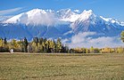
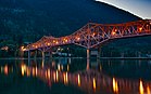
2269:
1555:
1461:
1188:
506:
291:
249:
210:
2453:
1873:
1455:
1287:
1192:
1140:
1124:
2337:
2239:
2177:
1565:
1200:
1187:). When used directly, it generally means the Okanagan and adjoining areas, particularly the
1184:
644:
589:
514:
427:
1400:(usually considered part of the Cariboo but shares more links geographically to the Thompson)
2422:
2362:
2342:
2312:
2289:
2187:
2028:
1559:
1550:
1533:
1511:
1449:
1374:
1369:
1353:
1196:
1156:
1148:
577:
510:
304:
166:
1856:
where it becomes a short freeway. Then it continues 496 km (308 mi) east through
2417:
2397:
2382:
2367:
2332:
2234:
2167:
1894:
1603:
1591:
1586:
1545:
1515:
1435:
1397:
1268:
1164:
616:
585:
581:
557:
149:
199:
2407:
2372:
2322:
2307:
2274:
2259:
2219:
2182:
1877:
1845:
1599:
1595:
1467:
1405:
1335:
1254:
1152:
1108:
1003:
526:
1805:
1762:
1722:
1679:
1639:
444:
423:
2485:
2457:
2412:
2392:
2357:
2347:
2244:
1841:
1611:
1572:
1540:
1497:
1480:
1443:
1331:
1204:
1180:
1080:
604:
600:
565:
518:
485:
481:
477:
473:
237:
1988:
2249:
2229:
1996:
1576:
1439:
1409:
1308:
620:
353:
17:
2254:
1615:
1523:
1490:
1304:
1297:
1293:
1120:
42:
2157:
1312:
522:
181:
2352:
1474:
1334:– a.k.a. "The Canyon". This term is often used to include the canyon of the
1208:
418:
348:
1074:, which lies just south of the big bend in the upper Fraser. The city of
2377:
2162:
1853:
1415:
1383:
330:
2327:
2172:
1424:
1244:
1067:
323:
229:
588:
and, in the northeast, British Columbia's sector of the Prairies, the
284:
1606:, and only a part of the Stikine Country, most of which is in the
1350:
is usually referred to as both the Canyon and the Fraser Canyon.
2000:
1199:. Due to a new federal political riding of the same name (see
1800:
1757:
1717:
1674:
1634:
1452:– often included with the West Kootenay, or with the Okanagan.
36:
647:
of British Columbia defined as being in the Interior region:
1282:
West Cariboo – was once used for the Bridge River Country.
1127:
included the upper Peace River through its canyon between
1876:(the highest point on the highway, at 1,627 metres), to
1965:"2016 British Columbia Census Total Population Results"
1915:"2016 British Columbia Census Total Population Results"
1817:
1774:
1734:
1691:
1651:
1203:) the usage has now come to apply to the cities of the
1183:
remainder of the old, original, Hudson's Bay Company
560:
movements. The ecology of the region is dominated by
615:, in the Fraser Canyon, or until the summits of the
2298:
2210:
2201:
2139:
2071:
2035:
1953:
Population Estimates - Province of British Columbia
1942:
Population Estimates - Province of British Columbia
1261:, sometimes including the Thompson as far south as
1066:The Northern Interior begins somewhere between the
467:
455:
434:
417:
409:
401:
393:
385:
377:
372:
310:
290:
272:
144:
67:. Unsourced material may be challenged and removed.
30:"The Interior" redirects here. For other uses, see
1614:, which refers to areas immediately adjoining the
1522:is often included in the East Kootenay, while the
1464:– frequently included with the southern Okanagan.
1139:The Central Interior is composed, roughly, of the
1318:South Chilcotin – sometimes used for part of the
1530:is usually considered part the West Kootenay.
2012:
8:
1937:
1935:
27:Interior region of British Columbia, Canada
2207:
2019:
2005:
1997:
1602:(also known as the Atlin Country) and the
1579:as Skeena-Bulkley, along the route of the
649:
141:
568:found atop its numerous mountain ranges.
381:669,648 km (258,553 sq mi)
127:Learn how and when to remove this message
1906:
1430:North Okanagan (also Northern Okanagan)
454:
416:
400:
392:
384:
371:
320:
309:
271:
263:
172:
1710:As of 2016 the population is 961,155.
1575:– often combined with the sub-coastal
1219:The Big Bend of the Columbia and the
517:that do not have coastline along the
466:
433:
408:
376:
289:
7:
1608:Regional District of Kitimat–Stikine
154:Intérieur de la Colombie-Britannique
139:Region of British Columbia in Canada
65:adding citations to reliable sources
2465:
1423:Central Okanagan – the area around
1103:and Tumbler Ridge in the south, to
1111:in the west, to Fort St. John and
552:parks connected by the province's
25:
1057:Major subregions and nomenclature
2464:
2452:
2441:
2440:
1804:
1761:
1721:
1678:
1638:
505:, is a geographic region of the
297:
277:
216:
209:
198:
191:
180:
41:
576:The region, which includes the
497:, popularly referred to as the
52:needs additional citations for
2106:Mountain resort municipalities
1989:BC Names entry "Robson Valley"
1442:, but not including the upper
1:
1227:Historical geographic regions
1207:, along with the rest of the
389:4,671 m (15,325 ft)
2492:Interior of British Columbia
2470:WikiProject:British Columbia
1516:valley of the Upper Columbia
1175:Southern Interior Cordillera
1062:Northern Interior Cordillera
599:, at the eastern end of the
2096:Indian government districts
1135:Central Interior Cordillera
562:temperate coniferous forest
76:"British Columbia Interior"
2508:
1324:Spruce Lake Protected Area
1169:Spruce Lake Protected Area
525:, and are not part of the
29:
2446:Category:British Columbia
2435:
1610:and includes some of the
1171:, but this is incorrect.
584:and reaching east to the
495:British Columbia Interior
413:7.41/km (19.2/sq mi)
378: • 14 Districts
264:
228:From top, left to right:
173:
160:
146:British Columbia Interior
397:127 m (417 ft)
2091:District municipalities
2063:Counties (court system)
1119:and other parts of the
1101:Monkman Provincial Park
1095:Northern Interior Plain
603:and at the foot of the
1890:British Columbia Coast
1477:a.k.a. "the Kootenay"
386:Highest elevation
153:
2193:Census agglomerations
2111:Resort municipalities
2101:Island municipalities
1623:Rocky Mountain Trench
1346:, partly because the
1221:Rocky Mountain Trench
436: • Summer (
394:Lowest elevation
2318:Bridge River Country
1838:Trans-Canada Highway
1360:Bridge River Country
1320:Bridge River Country
950:Okanagan-Similkameen
456:Postal code prefixes
410: • Density
61:improve this article
2403:Similkameen Country
2388:Peace River Country
2270:Sea-to-Sky Corridor
1754:Society and culture
1556:Peace River Country
1462:Similkameen Country
1131:and Hudson's Hope.
653:Regional Districts
250:Hudson Bay Mountain
2043:Regional districts
1874:Kicking Horse Pass
1816:. You can help by
1773:. You can help by
1733:. You can help by
1690:. You can help by
1650:. You can help by
1581:Yellowhead Highway
1438:– the area around
1382:– the area around
1303:North Chilcotin –
1193:southern Monashees
1125:W.A.C. Bennett Dam
842:Fraser-Fort George
645:regional districts
639:Regional Districts
515:regional districts
2479:
2478:
2431:
2430:
2338:Chilcotin Country
2240:Discovery Islands
2178:Greater Vancouver
1834:
1833:
1791:
1790:
1751:
1750:
1708:
1707:
1668:
1667:
1594:(not the same as
1566:Peace River Block
1398:Bonaparte Country
1292:West Chilcotin –
1269:Bonaparte Country
1249:South Cariboo – (
1201:Southern Interior
1185:Columbia District
1165:Shuswap Countries
1151:, Fraser Canyon,
1054:
1053:
869:Kootenay Boundary
643:Below are the 14
590:Peace River Block
535:Squamish–Lillooet
507:Canadian province
491:
490:
236:train traversing
137:
136:
129:
111:
18:Southern Interior
16:(Redirected from
2499:
2468:
2467:
2456:
2444:
2443:
2423:Thompson Country
2363:Lillooet Country
2343:Columbia Country
2313:Boundary Country
2290:Vancouver Island
2208:
2188:Greater Victoria
2048:School districts
2029:British Columbia
2027:Subdivisions of
2021:
2014:
2007:
1998:
1991:
1986:
1980:
1979:
1977:
1976:
1967:. Archived from
1961:
1955:
1950:
1944:
1939:
1930:
1929:
1927:
1926:
1917:. Archived from
1911:
1829:
1826:
1808:
1801:
1786:
1783:
1765:
1758:
1746:
1743:
1725:
1718:
1703:
1700:
1682:
1675:
1663:
1660:
1642:
1635:
1560:northern Alberta
1551:Cassiar District
1534:Big Bend Country
1526:region south of
1450:Boundary Country
1375:Thompson Plateau
1370:Thompson Country
1354:Lillooet Country
1197:Boundary Country
1070:and the city of
1045:
1040:
1035:
1020:
1015:
1010:
993:
988:
983:
966:
961:
956:
939:
934:
929:
923:Northern Rockies
912:
907:
902:
885:
880:
875:
858:
853:
848:
831:
826:
821:
804:
799:
794:
788:Columbia-Shuswap
777:
772:
767:
761:Central Okanagan
750:
745:
740:
734:Central Kootenay
723:
718:
713:
696:
691:
686:
650:
578:Interior Plateau
564:with patches of
511:British Columbia
441:
311:Principal cities
305:British Columbia
303:
301:
300:
283:
281:
280:
258:Central Kootenay
220:
213:
202:
195:
184:
167:British Columbia
142:
132:
125:
121:
118:
112:
110:
69:
45:
37:
21:
2507:
2506:
2502:
2501:
2500:
2498:
2497:
2496:
2482:
2481:
2480:
2475:
2427:
2418:Stikine Country
2398:Shuswap Country
2383:Omineca Country
2368:Nechako Country
2333:Cassiar Country
2294:
2235:Cowichan Valley
2197:
2168:Greater Kelowna
2141:
2140:Metro areas and
2135:
2131:Indian reserves
2067:
2031:
2025:
1995:
1994:
1987:
1983:
1974:
1972:
1963:
1962:
1958:
1951:
1947:
1940:
1933:
1924:
1922:
1913:
1912:
1908:
1903:
1895:Interior Health
1886:
1830:
1824:
1821:
1814:needs expansion
1799:
1787:
1781:
1778:
1771:needs expansion
1756:
1747:
1741:
1738:
1731:needs expansion
1716:
1704:
1698:
1695:
1688:needs expansion
1673:
1664:
1658:
1655:
1648:needs expansion
1633:
1604:Cassiar Country
1592:Stikine Country
1558:– extends into
1546:Omineca Country
1436:Shuswap Country
1279:Central Cariboo
1229:
1217:
1177:
1137:
1097:
1064:
1059:
1043:
1038:
1033:
1029:Thompson-Nicola
1018:
1013:
1008:
991:
986:
981:
964:
959:
954:
937:
932:
927:
910:
905:
900:
883:
878:
873:
856:
851:
846:
829:
824:
819:
802:
797:
792:
775:
770:
765:
748:
743:
738:
721:
716:
711:
694:
689:
684:
680:Bulkley-Nechako
673:
669:
667:
662:
657:
641:
586:Rocky Mountains
582:Coast Mountains
574:
539:Kitimat–Stikine
463:
435:
368:
319:
318:
298:
296:
278:
276:
268:
265:Nickname:
260:
226:
225:
224:
223:
222:
221:
214:
205:
204:
203:
196:
187:
186:
185:
169:
156:
147:
140:
133:
122:
116:
113:
70:
68:
58:
46:
35:
28:
23:
22:
15:
12:
11:
5:
2505:
2503:
2495:
2494:
2484:
2483:
2477:
2476:
2474:
2473:
2461:
2449:
2436:
2433:
2432:
2429:
2428:
2426:
2425:
2420:
2415:
2410:
2408:Skeena Country
2405:
2400:
2395:
2390:
2385:
2380:
2375:
2373:Nicola Country
2370:
2365:
2360:
2355:
2350:
2345:
2340:
2335:
2330:
2325:
2323:Bulkley Valley
2320:
2315:
2310:
2308:Atlin District
2304:
2302:
2296:
2295:
2293:
2292:
2287:
2285:Sunshine Coast
2282:
2277:
2275:Skeena Country
2272:
2267:
2262:
2260:Lower Mainland
2257:
2252:
2247:
2242:
2237:
2232:
2227:
2222:
2220:Alberni Valley
2216:
2214:
2205:
2199:
2198:
2196:
2195:
2190:
2185:
2183:Greater Vernon
2180:
2175:
2170:
2165:
2160:
2155:
2145:
2143:
2142:agglomerations
2137:
2136:
2134:
2133:
2128:
2123:
2118:
2113:
2108:
2103:
2098:
2093:
2088:
2083:
2081:Municipalities
2077:
2075:
2069:
2068:
2066:
2065:
2060:
2058:Health regions
2055:
2053:Land districts
2050:
2045:
2039:
2037:
2033:
2032:
2026:
2024:
2023:
2016:
2009:
2001:
1993:
1992:
1981:
1956:
1945:
1931:
1905:
1904:
1902:
1899:
1898:
1897:
1892:
1885:
1882:
1846:Lower Mainland
1832:
1831:
1811:
1809:
1798:
1797:Transportation
1795:
1789:
1788:
1768:
1766:
1755:
1752:
1749:
1748:
1728:
1726:
1715:
1712:
1706:
1705:
1685:
1683:
1672:
1669:
1666:
1665:
1645:
1643:
1632:
1629:
1628:
1627:
1619:
1600:Atlin District
1596:Stikine Region
1589:
1584:
1577:Skeena Country
1570:
1569:
1568:
1553:
1548:
1543:
1538:
1537:
1536:
1509:
1508:
1507:
1506:
1505:
1495:
1494:
1493:
1488:
1472:
1471:
1470:
1459:
1453:
1447:
1433:
1432:
1431:
1428:
1421:
1420:South Okanagan
1413:
1406:Nicola Country
1403:
1402:
1401:
1395:
1380:South Thompson
1377:
1367:
1366:
1365:
1364:
1363:
1336:Thompson River
1329:
1328:
1327:
1316:
1301:
1285:
1284:
1283:
1280:
1277:
1274:
1273:
1272:
1255:100 Mile House
1228:
1225:
1216:
1213:
1176:
1173:
1136:
1133:
1121:Liard drainage
1109:Williston Lake
1096:
1093:
1063:
1060:
1058:
1055:
1052:
1051:
1046:
1041:
1036:
1031:
1025:
1024:
1021:
1016:
1011:
1006:
1004:Stikine Region
1000:
999:
994:
989:
984:
979:
973:
972:
967:
962:
957:
952:
946:
945:
940:
935:
930:
925:
919:
918:
913:
908:
903:
898:
896:North Okanagan
892:
891:
886:
881:
876:
871:
865:
864:
859:
854:
849:
844:
838:
837:
832:
827:
822:
817:
811:
810:
805:
800:
795:
790:
784:
783:
778:
773:
768:
763:
757:
756:
751:
746:
741:
736:
730:
729:
724:
719:
714:
709:
703:
702:
697:
692:
687:
682:
676:
675:
670:
664:
659:
654:
640:
637:
621:Allison Passes
573:
570:
558:tectonic plate
527:Lower Mainland
501:or simply the
489:
488:
471:
465:
464:
459:
457:
453:
452:
442:
432:
431:
421:
415:
414:
411:
407:
406:
403:
399:
398:
395:
391:
390:
387:
383:
382:
379:
375:
374:
370:
369:
367:
366:
361:
356:
351:
346:
341:
334:
327:
316:
315:
314:
312:
308:
307:
294:
288:
287:
274:
270:
269:
267:"The Interior"
266:
262:
261:
227:
215:
208:
207:
206:
197:
190:
189:
188:
179:
178:
177:
176:
175:
174:
171:
170:
161:
158:
157:
148:
145:
138:
135:
134:
117:September 2013
49:
47:
40:
26:
24:
14:
13:
10:
9:
6:
4:
3:
2:
2504:
2493:
2490:
2489:
2487:
2472:
2471:
2462:
2460:
2459:
2458:Portal:Canada
2455:
2450:
2448:
2447:
2438:
2437:
2434:
2424:
2421:
2419:
2416:
2414:
2413:Slocan Valley
2411:
2409:
2406:
2404:
2401:
2399:
2396:
2394:
2393:Robson Valley
2391:
2389:
2386:
2384:
2381:
2379:
2376:
2374:
2371:
2369:
2366:
2364:
2361:
2359:
2358:Liard Country
2356:
2354:
2351:
2349:
2348:Fraser Canyon
2346:
2344:
2341:
2339:
2336:
2334:
2331:
2329:
2326:
2324:
2321:
2319:
2316:
2314:
2311:
2309:
2306:
2305:
2303:
2301:
2297:
2291:
2288:
2286:
2283:
2281:
2278:
2276:
2273:
2271:
2268:
2266:
2263:
2261:
2258:
2256:
2253:
2251:
2248:
2246:
2245:Fraser Valley
2243:
2241:
2238:
2236:
2233:
2231:
2228:
2226:
2225:Central Coast
2223:
2221:
2218:
2217:
2215:
2213:
2209:
2206:
2204:
2200:
2194:
2191:
2189:
2186:
2184:
2181:
2179:
2176:
2174:
2171:
2169:
2166:
2164:
2161:
2159:
2156:
2154:
2150:
2147:
2146:
2144:
2138:
2132:
2129:
2127:
2124:
2122:
2119:
2117:
2114:
2112:
2109:
2107:
2104:
2102:
2099:
2097:
2094:
2092:
2089:
2087:
2084:
2082:
2079:
2078:
2076:
2074:
2070:
2064:
2061:
2059:
2056:
2054:
2051:
2049:
2046:
2044:
2041:
2040:
2038:
2034:
2030:
2022:
2017:
2015:
2010:
2008:
2003:
2002:
1999:
1990:
1985:
1982:
1971:on 2019-07-24
1970:
1966:
1960:
1957:
1954:
1949:
1946:
1943:
1938:
1936:
1932:
1921:on 2019-07-24
1920:
1916:
1910:
1907:
1900:
1896:
1893:
1891:
1888:
1887:
1883:
1881:
1879:
1875:
1871:
1867:
1863:
1859:
1855:
1851:
1847:
1843:
1842:Fraser Canyon
1839:
1828:
1819:
1815:
1812:This section
1810:
1807:
1803:
1802:
1796:
1794:
1785:
1776:
1772:
1769:This section
1767:
1764:
1760:
1759:
1753:
1745:
1736:
1732:
1729:This section
1727:
1724:
1720:
1719:
1713:
1711:
1702:
1693:
1689:
1686:This section
1684:
1681:
1677:
1676:
1670:
1662:
1653:
1649:
1646:This section
1644:
1641:
1637:
1636:
1630:
1624:
1621:the northern
1620:
1617:
1613:
1612:Liard Country
1609:
1605:
1601:
1597:
1593:
1590:
1588:
1585:
1582:
1578:
1574:
1571:
1567:
1564:
1563:
1561:
1557:
1554:
1552:
1549:
1547:
1544:
1542:
1541:Robson Valley
1539:
1535:
1532:
1531:
1529:
1525:
1521:
1517:
1513:
1510:
1504:
1501:
1500:
1499:
1498:East Kootenay
1496:
1492:
1489:
1487:
1484:
1483:
1482:
1481:West Kootenay
1479:
1478:
1476:
1475:The Kootenays
1473:
1469:
1466:
1465:
1463:
1460:
1457:
1456:The Monashees
1454:
1451:
1448:
1445:
1444:Shuswap River
1441:
1437:
1434:
1429:
1426:
1422:
1419:
1418:
1417:
1414:
1411:
1407:
1404:
1399:
1396:
1393:
1389:
1385:
1381:
1378:
1376:
1373:
1372:
1371:
1368:
1361:
1358:
1357:
1355:
1352:
1351:
1349:
1348:highway route
1345:
1341:
1337:
1333:
1332:Fraser Canyon
1330:
1325:
1321:
1317:
1314:
1310:
1306:
1302:
1299:
1295:
1291:
1290:
1289:
1288:The Chilcotin
1286:
1281:
1278:
1276:North Cariboo
1275:
1270:
1267:
1266:
1264:
1260:
1256:
1252:
1248:
1247:
1246:
1243:
1242:
1241:
1238:
1235:
1226:
1224:
1222:
1214:
1212:
1210:
1206:
1205:West Kootenay
1202:
1198:
1194:
1190:
1186:
1182:
1181:Oregon Treaty
1174:
1172:
1170:
1166:
1162:
1158:
1154:
1150:
1146:
1142:
1134:
1132:
1130:
1126:
1123:, and before
1122:
1118:
1114:
1110:
1106:
1105:Hudson's Hope
1102:
1094:
1092:
1088:
1086:
1082:
1081:Robson Valley
1077:
1073:
1072:Prince George
1069:
1061:
1056:
1050:
1047:
1042:
1037:
1032:
1030:
1027:
1026:
1022:
1017:
1012:
1007:
1005:
1002:
1001:
998:
995:
990:
985:
980:
978:
975:
974:
971:
968:
963:
958:
953:
951:
948:
947:
944:
941:
936:
931:
926:
924:
921:
920:
917:
914:
909:
904:
899:
897:
894:
893:
890:
887:
882:
877:
872:
870:
867:
866:
863:
862:Prince George
860:
855:
850:
845:
843:
840:
839:
836:
833:
828:
823:
818:
816:
815:East Kootenay
813:
812:
809:
806:
801:
796:
791:
789:
786:
785:
782:
779:
774:
769:
764:
762:
759:
758:
755:
752:
747:
742:
737:
735:
732:
731:
728:
727:Williams Lake
725:
720:
715:
710:
708:
705:
704:
701:
698:
693:
688:
683:
681:
678:
677:
671:
665:
660:
655:
652:
651:
648:
646:
638:
636:
632:
630:
626:
622:
618:
614:
610:
606:
605:Fraser Canyon
602:
601:Fraser Valley
598:
593:
591:
587:
583:
579:
571:
569:
567:
566:alpine tundra
563:
559:
555:
551:
547:
542:
540:
536:
532:
531:Fraser Valley
528:
524:
520:
519:Pacific Ocean
516:
512:
508:
504:
500:
496:
487:
483:
479:
475:
472:
470:
462:
458:
450:
446:
443:
439:
429:
425:
422:
420:
412:
404:
396:
388:
380:
365:
362:
360:
359:Fort St. John
357:
355:
352:
350:
347:
345:
342:
340:
339:
338:Prince George
335:
333:
332:
328:
326:
325:
321:
313:
306:
295:
293:
286:
275:
259:
255:
254:Nelson Bridge
251:
247:
246:Prince George
243:
239:
238:Fraser Canyon
235:
231:
219:
212:
201:
194:
183:
168:
164:
159:
155:
151:
143:
131:
128:
120:
109:
106:
102:
99:
95:
92:
88:
85:
81:
78: –
77:
73:
72:Find sources:
66:
62:
56:
55:
50:This article
48:
44:
39:
38:
33:
19:
2463:
2451:
2439:
2299:
2250:Gulf Islands
2230:Comox Valley
2036:Subdivisions
1984:
1973:. Retrieved
1969:the original
1959:
1948:
1923:. Retrieved
1919:the original
1909:
1835:
1822:
1818:adding to it
1813:
1792:
1779:
1775:adding to it
1770:
1739:
1735:adding to it
1730:
1709:
1696:
1692:adding to it
1687:
1671:Demographics
1656:
1652:adding to it
1647:
1512:The Columbia
1468:The Tulameen
1440:Shuswap Lake
1416:The Okanagan
1410:Nicola River
1309:Alexis Creek
1239:
1233:
1230:
1218:
1178:
1145:Bridge River
1138:
1129:Finlay Forks
1113:Charlie Lake
1098:
1089:
1065:
997:Dawson Creek
642:
633:
595:The town of
594:
575:
543:
502:
498:
494:
492:
354:West Kelowna
336:
329:
322:
123:
114:
104:
97:
90:
83:
71:
59:Please help
54:verification
51:
2280:South Coast
2265:North Coast
2255:Haida Gwaii
2126:Ghost towns
2073:Communities
1880:, Alberta.
1866:Rogers Pass
1850:Cache Creek
1616:Liard River
1587:The Nechako
1573:The Bulkley
1524:Arrow Lakes
1491:Arrow Lakes
1305:Anahim Lake
1300:Lakes area.
1259:Bridge Lake
1245:The Cariboo
1189:Similkameen
1143:, Cariboo,
1117:Fort Nelson
1085:North Coast
977:Peace River
943:Fort Nelson
672:Head office
572:Definitions
499:BC Interior
2158:Chilliwack
2149:Abbotsford
1975:2019-10-23
1925:2019-10-23
1901:References
1862:Revelstoke
1858:Salmon Arm
1528:Revelstoke
1503:Elk Valley
1313:Nimpo Lake
1215:Exceptions
916:Coldstream
808:Salmon Arm
700:Burns Lake
656:Population
617:Coquihalla
613:Boston Bar
546:provincial
523:Salish Sea
469:Area codes
402:Population
87:newspapers
2353:Kootenays
1825:June 2008
1782:June 2008
1742:June 2008
1699:June 2008
1659:June 2008
1518:south of
1209:Kootenays
1141:Chilcotin
970:Penticton
835:Cranbrook
674:location
629:Pemberton
445:UTC−07:00
424:UTC−08:00
419:Time zone
364:Cranbrook
349:Penticton
2486:Category
2378:Okanagan
2300:Interior
2163:Kamloops
2121:Villages
1884:See also
1854:Kamloops
1626:Country.
1392:Ashcroft
1384:Kamloops
1340:Ashcroft
1338:between
1161:Kamloops
1157:Thompson
1149:Lillooet
1107:and the
1049:Kamloops
625:Whistler
550:national
503:Interior
331:Kamloops
292:Province
242:Ashcroft
32:Interior
2328:Cariboo
2203:Regions
2173:Nanaimo
2153:Mission
1848:toward
1844:in the
1714:Economy
1631:History
1425:Kelowna
1386:, from
1251:Clinton
1234:without
1076:Quesnel
1068:Cariboo
1034:132,663
1023:(n/a)*
1014:118,663
987:117,391
781:Kelowna
766:194,882
707:Cariboo
666:Density
658:(2016)
554:highway
405:961,155
324:Kelowna
273:Country
230:Kelowna
101:scholar
2086:Cities
1872:, and
1870:Golden
1520:Golden
1514:– the
1486:Slocan
1344:Lytton
1298:Taseko
1294:Chilko
1263:Lytton
1153:Nicola
1039:44,448
982:62,942
960:10,414
955:83,022
933:85,111
901:84,354
874:31,447
852:50,676
847:94,506
825:27,543
820:60,439
798:28,929
793:51,366
754:Nelson
744:22,095
739:59,517
717:80,609
712:61,988
690:73,361
685:37,896
548:, and
537:, and
344:Vernon
302:
285:Canada
282:
163:Region
150:French
103:
96:
89:
82:
74:
2212:Coast
2116:Towns
1878:Banff
1388:Chase
1322:(see
928:5,393
906:7,503
889:Trail
879:8,082
771:2,905
668:(/km)
663:(km)
240:near
108:JSTOR
94:books
1836:The
1342:and
1296:and
1195:and
1159:and
1019:0.01
992:0.54
938:0.06
911:11.2
776:67.1
722:0.77
695:0.52
661:Area
627:and
619:and
611:and
609:Yale
597:Hope
493:The
373:Area
317:List
80:news
1820:.
1777:.
1737:.
1694:.
1654:.
1390:to
1044:3.0
1009:740
965:8.0
884:3.9
857:1.9
830:2.2
803:1.8
749:2.7
521:or
509:of
486:778
482:672
478:250
474:236
449:PDT
438:DST
428:PST
256:in
165:of
63:by
2488::
1934:^
1868:,
1864:,
1860:,
1562:.
1326:).
1311:,
1307:,
1265:.
1191:,
1155:,
541:.
533:,
484:,
480:,
476:,
252:,
248:,
244:,
234:CN
232:,
152::
2151:–
2020:e
2013:t
2006:v
1978:.
1928:.
1827:)
1823:(
1784:)
1780:(
1744:)
1740:(
1701:)
1697:(
1661:)
1657:(
1618:.
1583:.
1427:.
1412:.
1394:.
1315:.
1257:-
1253:-
1163:-
1147:-
461:V
451:)
447:(
440:)
430:)
426:(
130:)
124:(
119:)
115:(
105:·
98:·
91:·
84:·
57:.
34:.
20:)
Text is available under the Creative Commons Attribution-ShareAlike License. Additional terms may apply.