433:
142:
22:
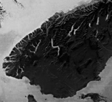
NASA satellite image of the
Southern Lakes, looking north-northwest. The prominent central zigzag is Lake Wakatipu; to the north are the twin lakes of Wānaka and Hāwea, beyond which lie the Mackenzie Basin's Ōhau, Pukaki, and Tekapo. To the left of Wakatipu is the branched form of Lake Te Anau; south
35:
of New
Zealand. Despite being an unofficial designation, the term Southern Lakes is sometimes used by organisations such as the New Zealand Meteorological Service and Automobile Association. Though exact definitions vary, the area encompasses parts of western
19:
149:
Lakes with a surface area of more than 20 square kilometres (7.7 sq mi). Those listed as being in
Canterbury are often excluded from definitions of the Southern Lakes.
63:
during the last ice age, and as such contains many broad U-shaped valleys, several of which are filled with large lakes. These include the country's deepest lake,
439:
67:, and three of the country's four largest lakes. If the Mackenzie Basin is included, seven of the country's ten largest lakes form part of the Southern Lakes.
432:
496:
501:
59:
The region is generally lightly populated, with much of its southwestern part being uninhabited national park. Much of the scenery was heavily
491:
122:
53:
111:
37:
472:
56:, a total of roughly 28,000 to 35,000 square kilometres (11,000 to 14,000 sq mi).
423:
343:
49:
23:
of this is the smaller
Manapouri and – close to the south coast – Hauroko and Poteriteri.
252:
216:
107:
79:
485:
379:
270:
198:
115:
95:
83:
75:
45:
460:
415:
397:
361:
306:
187:
175:
103:
99:
87:
71:
64:
32:
325:
288:
234:
419:
141:
60:
91:
41:
126:
70:
Many of the region's lakes feed the country's second-longest river, the
18:
130:
140:
17:
114:. The northern group of Mackenzie Basin lakes form part of the
31:
is an unofficial name given to an area of the southern
48:, and is occasionally extended to include the
8:
74:, and its tributaries — these include Lakes
151:
426:, part of the Canterbury-Otago boundary.
121:The areas main centres of population are
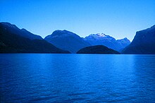
442:Panorama of Queenstown and Lake Wakatipu
453:
7:
102:at Roxburgh). Other lakes, such as
86:, as well as the artificial lakes
14:
203:291 km (112 sq mi)
180:344 km (133 sq mi)
431:
414:Other notable lakes include the
275:141 km (54 sq mi)
257:142 km (55 sq mi)
239:179 km (69 sq mi)
221:192 km (74 sq mi)
190:, Second largest in New Zealand
402:26 km (10 sq mi)
384:28 km (11 sq mi)
366:31 km (12 sq mi)
348:43 km (17 sq mi)
330:63 km (24 sq mi)
311:63 km (24 sq mi)
293:83 km (32 sq mi)
497:Lakes of the Canterbury Region
1:
502:Lakes of the Southland Region
422:in Otago, and the artificial
317:New Zealand's deepest lake
518:
92:hydroelectric dam at Clyde
90:(formed on the river by a
110:, feed the system of the
100:similar but smaller dam
146:
24:
144:
21:
186:Largest lake in the
147:
25:
412:
411:
98:(formed behind a
509:
476:
470:
464:
463:, NZ Metservice.
458:
435:
152:
517:
516:
512:
511:
510:
508:
507:
506:
482:
481:
480:
479:
475:, AA Traveller.
471:
467:
459:
455:
450:
445:
444:
443:
441:
436:
424:Lake Ruataniwha
344:Lake Poteriteri
139:
50:Mackenzie Basin
12:
11:
5:
515:
513:
505:
504:
499:
494:
492:Lakes of Otago
484:
483:
478:
477:
473:Southern Lakes
465:
461:Southern Lakes
452:
451:
449:
446:
438:
437:
430:
429:
428:
418:of Southland,
410:
409:
406:
403:
400:
395:
391:
390:
388:
385:
382:
377:
373:
372:
370:
367:
364:
359:
355:
354:
352:
349:
346:
341:
337:
336:
334:
331:
328:
323:
319:
318:
315:
312:
309:
304:
300:
299:
297:
294:
291:
286:
282:
281:
279:
276:
273:
268:
264:
263:
261:
258:
255:
253:Lake Manapouri
250:
246:
245:
243:
240:
237:
232:
228:
227:
225:
222:
219:
214:
210:
209:
207:
204:
201:
196:
192:
191:
184:
181:
178:
173:
169:
168:
165:
162:
159:
156:
138:
135:
133:in Southland.
129:in Otago, and
29:Southern Lakes
13:
10:
9:
6:
4:
3:
2:
514:
503:
500:
498:
495:
493:
490:
489:
487:
474:
469:
466:
462:
457:
454:
447:
440:
434:
427:
425:
421:
417:
407:
404:
401:
399:
396:
393:
392:
389:
386:
383:
381:
380:Lake McKerrow
378:
375:
374:
371:
368:
365:
363:
360:
357:
356:
353:
350:
347:
345:
342:
339:
338:
335:
332:
329:
327:
324:
321:
320:
316:
313:
310:
308:
305:
302:
301:
298:
295:
292:
290:
287:
284:
283:
280:
277:
274:
272:
269:
266:
265:
262:
259:
256:
254:
251:
248:
247:
244:
241:
238:
236:
233:
230:
229:
226:
223:
220:
218:
215:
212:
211:
208:
205:
202:
200:
199:Lake Wakatipu
197:
194:
193:
189:
185:
182:
179:
177:
174:
171:
170:
166:
163:
160:
157:
154:
153:
150:
143:
137:List of lakes
136:
134:
132:
128:
124:
119:
117:
116:Waitaki River
113:
109:
105:
101:
97:
93:
89:
85:
81:
77:
73:
68:
66:
62:
57:
55:
51:
47:
46:Central Otago
43:
39:
34:
30:
20:
16:
468:
456:
416:Mavora Lakes
413:
398:Lake Dunstan
362:Lake Monowai
307:Lake Hauroko
188:South Island
176:Lake Te Anau
161:Surface area
148:
145:Lake Te Anau
120:
72:Clutha River
69:
65:Lake Hauroko
58:
33:South Island
28:
26:
15:
408:Artificial
289:Lake Tekapo
235:Lake Pukaki
217:Lake Wānaka
112:Waiau River
40:(including
486:Categories
448:References
420:Lake Hayes
333:Canterbury
296:Canterbury
271:Lake Hāwea
242:Canterbury
123:Queenstown
54:Canterbury
52:of inland
387:Southland
369:Southland
351:Southland
326:Lake Ōhau
314:Southland
260:Southland
183:Southland
108:Manapouri
61:glaciated
42:Fiordland
38:Southland
118:system.
96:Roxburgh
76:Wakatipu
131:Te Anau
104:Te Anau
88:Dunstan
167:Notes
164:Region
127:Wānaka
94:) and
82:, and
80:Wānaka
44:) and
405:Otago
278:Otago
224:Otago
206:Otago
84:Hāwea
158:Name
155:Rank
125:and
106:and
27:The
488::
394:13
376:12
358:11
340:10
78:,
322:9
303:8
285:7
267:6
249:5
231:4
213:3
195:2
172:1
Text is available under the Creative Commons Attribution-ShareAlike License. Additional terms may apply.