294:
272:
250:
234:
212:
190:
171:
115:
257:
197:
25:
341:
35:
846:
336:
in 1892; the appropriation was not passed until 1895. Two identical octagonal towers were constructed, each equipped with a red reflector light. Originally painted white, they were repainted with a red band in the midsection in 1904. At the same time the two towers were relocated 15 feet (4.6 m)
352:
had been built on the island, immediately adjacent to the older lights. The two sets of lights were often confused, and when it was proposed to discontinue the
Spectacle Island range because the channel had shifted, the discontinuance was objected to because it was thought the other range was going
461:
379:
454:
484:
324:
in Boston Harbor. They were established in 1897 and discontinued in 1913 after changes in the entrance channels to the harbor made them obsolete.
865:
535:
349:
447:
344:
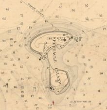
Spectacle Island in 1909, showing the
Spectacle Island range with five pointed stars and the Broad Sound Channel range with six pointed stars
730:
474:
740:
353:
to be eliminated. The confusion was cleared up and the objections withdrawn, and the
Spectacle Island range was discontinued in 1913.
685:
650:
400:
321:
52:
71:
655:
870:
615:
333:
715:
710:
64:
680:
545:
570:
795:
505:
735:
660:
815:
515:
845:
875:
810:
805:
695:
670:
620:
610:
550:
495:
293:
271:
233:
211:
830:
800:
665:
625:
590:
284:
224:
755:
700:
605:
500:
340:
170:
114:
790:
780:
765:
750:
595:
565:
540:
520:
825:
640:
585:
580:
530:
510:
775:
770:
705:
690:
675:
635:
820:
725:
600:
575:
555:
256:
196:
835:
760:
645:
630:
404:
317:
34:
24:
859:
560:
249:
189:
745:
720:
525:
429:
439:
470:
86:
73:
371:
403:. United States Coast Guard Historian's Office. 2009-08-08. Archived from
56:
332:
A range to mark the channel into Boston harbor was requested by the
401:"Historic Light Station Information and Photography: Massachusetts"
339:
443:
39:
A 1907 postcard showing the range lights (the two white towers)
372:"Lighthouses of the United States: Northern Massachusetts"
283:
264:
223:
204:
163:
158:
146:
138:
130:
122:
107:
102:
63:
48:
455:
8:
19:
424:
422:
420:
418:
416:
414:
380:University of North Carolina at Chapel Hill
462:
448:
440:
430:"New England Lighthouses: A Virtual Guide"
292:
270:
248:
232:
210:
188:
169:
113:
33:
18:
150:White, later white with red center stripe
485:List of lighthouses in the United States
395:
393:
391:
389:
187:Spectacle Island Range Front Light
362:
289:
247:Spectacle Island Range Rear Light
229:
350:Broad Sound Channel Inner Range Lights
7:
348:The year before the relocation, the
14:
432:. Jeremy D'Entremont. 2009-10-24.
844:
255:
195:
23:
731:Newburyport Harbor Front Range
626:Fort Pickering (Winter Island)
1:
866:Lighthouses completed in 1897
741:Newburyport Harbor Rear Range
314:Spectacle Island Range Lights
208:29 ft (8.8 m)
20:Spectacle Island Range Lights
370:Rowlett, Russ (2009-10-24).
268:54 ft (16 m)
892:
651:Hospital Point Range Front
842:
656:Hospital Point Range Rear
491:
481:
306:
302:
279:
246:
242:
219:
186:
182:
178:
154:
44:
32:
376:The Lighthouse Directory
816:Three Sisters of Nauset
786:Spectacle Island Range
716:Nantucket Harbor Range
345:
871:Lighthouses in Boston
711:Nantucket Cliff Range
546:Buzzards Bay Entrance
343:
811:Thacher Island North
681:Lovells Island Range
571:Cleveland East Ledge
796:Straitsmouth Island
536:Broad Sound Channel
506:Billingsgate Island
83: /
29:
736:Newburyport Harbor
661:Hyannis Rear Range
346:
853:
852:
516:Bishop and Clerks
310:
309:
883:
848:
806:Ten Pound Island
706:Nantucket Beacon
671:Long Island Head
621:Fairhaven Bridge
611:Edgartown Harbor
496:Annisquam Harbor
464:
457:
450:
441:
434:
433:
426:
409:
408:
397:
384:
383:
367:
334:Lighthouse Board
322:Spectacle Island
298:
297:
296:
275:
274:
260:
259:
252:
238:
237:
236:
215:
214:
200:
199:
192:
174:
173:
118:
117:
98:
97:
95:
94:
93:
88:
84:
81:
80:
79:
76:
53:Spectacle Island
37:
30:
28:
27:
891:
890:
886:
885:
884:
882:
881:
880:
856:
855:
854:
849:
840:
487:
477:
468:
438:
437:
428:
427:
412:
399:
398:
387:
369:
368:
364:
359:
330:
316:were a pair of
291:
269:
253:
231:
209:
193:
168:
112:
91:
89:
87:42.33°N 70.98°W
85:
82:
77:
74:
72:
70:
69:
40:
21:
17:
12:
11:
5:
889:
887:
879:
878:
873:
868:
858:
857:
851:
850:
843:
841:
839:
838:
833:
828:
823:
818:
813:
808:
803:
801:Tarpaulin Cove
798:
793:
788:
783:
778:
773:
768:
763:
758:
753:
748:
743:
738:
733:
728:
723:
718:
713:
708:
703:
698:
693:
688:
683:
678:
673:
668:
663:
658:
653:
648:
643:
638:
633:
628:
623:
618:
613:
608:
603:
598:
593:
591:Dumpling Rocks
588:
583:
578:
573:
568:
563:
558:
553:
548:
543:
538:
533:
528:
523:
518:
513:
508:
503:
498:
492:
489:
488:
482:
479:
478:
469:
467:
466:
459:
452:
444:
436:
435:
410:
407:on 2017-05-01.
385:
361:
360:
358:
355:
329:
326:
308:
307:
304:
303:
300:
299:
287:
285:Characteristic
281:
280:
277:
276:
266:
262:
261:
244:
243:
240:
239:
227:
225:Characteristic
221:
220:
217:
216:
206:
202:
201:
184:
183:
180:
179:
176:
175:
165:
161:
160:
156:
155:
152:
151:
148:
144:
143:
140:
136:
135:
132:
128:
127:
124:
120:
119:
109:
105:
104:
100:
99:
67:
61:
60:
50:
46:
45:
42:
41:
38:
15:
13:
10:
9:
6:
4:
3:
2:
888:
877:
876:Boston Harbor
874:
872:
869:
867:
864:
863:
861:
847:
837:
834:
832:
829:
827:
824:
822:
819:
817:
814:
812:
809:
807:
804:
802:
799:
797:
794:
792:
789:
787:
784:
782:
779:
777:
774:
772:
769:
767:
764:
762:
759:
757:
756:Palmer Island
754:
752:
749:
747:
744:
742:
739:
737:
734:
732:
729:
727:
724:
722:
719:
717:
714:
712:
709:
707:
704:
702:
701:Monomoy Point
699:
697:
696:Minot's Ledge
694:
692:
689:
687:
684:
682:
679:
677:
674:
672:
669:
667:
666:Ipswich Range
664:
662:
659:
657:
654:
652:
649:
647:
644:
642:
639:
637:
634:
632:
629:
627:
624:
622:
619:
617:
614:
612:
609:
607:
606:Eastern Point
604:
602:
599:
597:
594:
592:
589:
587:
584:
582:
579:
577:
574:
572:
569:
567:
564:
562:
559:
557:
554:
552:
549:
547:
544:
542:
539:
537:
534:
532:
529:
527:
524:
522:
519:
517:
514:
512:
509:
507:
504:
502:
501:Bakers Island
499:
497:
494:
493:
490:
486:
480:
476:
475:Massachusetts
472:
465:
460:
458:
453:
451:
446:
445:
442:
431:
425:
423:
421:
419:
417:
415:
411:
406:
402:
396:
394:
392:
390:
386:
381:
377:
373:
366:
363:
356:
354:
351:
342:
338:
335:
327:
325:
323:
319:
315:
305:
301:
295:
288:
286:
282:
278:
273:
267:
263:
258:
251:
245:
241:
235:
228:
226:
222:
218:
213:
207:
203:
198:
191:
185:
181:
177:
172:
166:
162:
157:
153:
149:
145:
141:
137:
133:
129:
125:
121:
116:
110:
106:
101:
96:
92:42.33; -70.98
68:
66:
62:
58:
54:
51:
47:
43:
36:
31:
26:
791:Stage Harbor
785:
781:Sankaty Head
766:Point Gammon
751:Old Scituate
596:Duxbury Pier
566:Clarks Point
541:Butler Flats
521:Borden Flats
405:the original
375:
365:
347:
331:
318:range lights
313:
311:
131:Construction
831:Wing's Neck
826:West Dennis
641:Great Point
586:Derby Wharf
581:Deer Island
531:Brant Point
511:Bird Island
471:Lighthouses
164:Deactivated
108:Constructed
90: /
65:Coordinates
860:Categories
776:Sandy Neck
771:Race Point
691:Mayo Beach
686:Marblehead
676:Long Point
636:The Graves
357:References
167:1913
123:Foundation
111:1897
16:Lighthouse
821:West Chop
726:Ned Point
601:East Chop
576:Cuttyhunk
556:Cape Poge
290:F R
230:F R
142:octagonal
836:Wood End
761:Plymouth
646:Highland
631:Gay Head
616:Egg Rock
551:Cape Ann
147:Markings
49:Location
561:Chatham
337:south.
328:History
126:masonry
78:70°59′W
75:42°20′N
746:Nobska
721:Nauset
526:Boston
483:Main:
265:Height
205:Height
57:Boston
254:
194:
159:Light
139:Shape
103:Tower
22:
312:The
134:wood
59:, US
473:of
320:on
862::
413:^
388:^
378:.
374:.
55:,
463:e
456:t
449:v
382:.
Text is available under the Creative Commons Attribution-ShareAlike License. Additional terms may apply.